
Main-Spessart district
| coat of arms | Germany map |
|---|---|

|

Coordinates: 49 ° 59 ' N , 9 ° 40' E |
| Basic data | |
| State : | Bavaria |
| Administrative region : | Lower Franconia |
| Administrative headquarters : | Karlstadt |
| Area : | 1,321.42 km 2 |
| Residents: | 126,158 (Dec. 31, 2019) |
| Population density : | 95 inhabitants per km 2 |
| License plate : | MSP |
| Circle key : | 09 6 77 |
| NUTS : | DE26A |
| Circle structure: | 40 parishes |
| Address of the district administration: |
Marktplatz 8 97753 Karlstadt |
| Website : | |
| District Administrator : | Sabine Sitter ( CSU ) |
| Location of the Main-Spessart district in Bavaria | |
  |
|

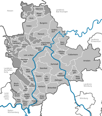
The district of Main-Spessart is located in the western center of the Bavarian administrative district of Lower Franconia . The district town is Karlstadt . The district is a member of the Regiopole region Mainfranken .
geography
The district is characterized by the Main and Spessart and lies between the three larger cities of Würzburg in the south, Schweinfurt in the east and Aschaffenburg in the west. Coming from Würzburg, the Main reaches the district in the southeast. It initially flows in a north-westerly direction, past Karlstadt to Gemünden , the so-called three-river city. There it takes on the Franconian Saale and Sinn rivers coming from the northeast and north , which have merged shortly before the mouth. After a few kilometers, the Main turns to the southwest and, on its further course, reaches the cities of Lohr am Main and from there to the south, Marktheidenfeld . A few kilometers south of Marktheidenfeld, the Main forms the state border with Baden-Württemberg . The last district municipality on the Main is the Kreuzwertheim market . There the Main flows westwards towards Miltenberg. Other rivers in the district in addition to the Main, the Franconian Saale and the Sinn are the Wern , which flows into the Main shortly before Gemünden, the Lohr, which flows into the Main near Lohr, and the Hafenlohr , which flows into the Main at the municipality of the same name, Hafenlohr .
To the west of the Main, the heights of the Spessart stretch up to over 500 m. The highest point in the Spessart is the 586 m high Geiersberg with the Breitsol transmitter near Rohrbrunn , it has been part of the district of Bischbrunn since 2009 . The Hermannskoppe with 567 m in the north of the district area, forms the border between Bavaria and Hesse.
Neighboring areas
The district borders clockwise in the northwest, starting with the Main-Kinzig district (in Hesse ), the districts Bad Kissingen , Schweinfurt and Würzburg (all in Bavaria), and the Main-Tauber district (in Baden-Württemberg ) as well the districts of Miltenberg and Aschaffenburg (both in Bavaria).
Nature reserves
The district has 15 nature reserves , two landscape protection areas , 20 FFH areas and 32 geotopes designated by the Bavarian State Office for the Environment (as of August 2016).
See also:
- List of nature reserves in the Main-Spessart district
- List of landscape protection areas in the Main-Spessart district
- List of FFH areas in the Main-Spessart district
- List of geotopes in the Main-Spessart district
history
Regional courts
Before 1800, the area of today's Main-Spessart district belonged mainly to the Würzburg monastery , partly to the Mainz ore monastery . The Electoral Mainz part was part of the Principality of Aschaffenburg from 1803 and came to the Kingdom of Bavaria in 1814 .
The district court of Homburg (seat in Marktheidenfeld ) was established as early as 1804 and was renamed in 1840 after its seat in the district court of Marktheidenfeld . In 1804 the regional courts of Gemünden , Karlstadt and Arnstein were established . In 1814 the district courts of Lohr and Orb were established. In 1852 the district court of Rothenfels emerged from the Fürstlich von Löwenstein rulership court of Rothenfels and one year later the district court Stadtprozelten from the Fürstlich von Löwenstein rulership court of Kreuzwertheim . All regional courts belonged to the Lower Main District , which was renamed Lower Franconia from 1838 .
District Offices
On January 1, 1862, the district office of Lohr was formed from the regional courts of Lohr and Rothenfels, the district office of Marktheidenfeld from the regional courts of Marktheidenfeld and Stadtprozelten, the district office of Karlstadt from the regional courts of Karlstadt and Arnstein, and the district office of Gemünden from the regional courts of Gemünden and Orb. As a result of the military defeat in 1866, Bavaria had to surrender the Orb area to Prussia . The now reduced Gemünden district was dissolved in 1872 and its communities incorporated into the Lohr district office. For this, the Lohr district office gave the area around Rothenfels to the Marktheidenfeld district office. In 1902 Gemünden again became the seat of a district office.
Counties
On January 1, 1939, the designation district was introduced as everywhere else in the German Reich . The district offices became the districts of Gemünden am Main, Karlstadt, Lohr am Main and Marktheidenfeld.
Main-Spessart district
As part of the regional reform in Bavaria , on July 1, 1972, a new district was initially named "Landkreis Mittelmain" from the former districts of Gemünden am Main , Lohr am Main (excluding the community of Rothenbuch , which came to the district of Aschaffenburg ) and Karlstadt (some Peripheral communities also came to the neighboring districts of Schweinfurt , Würzburg and Bad Kissingen ) and most of the Marktheidenfeld district (the area around Stadtprozelten , however, came to the Miltenberg district , some communities in the southeast to the Würzburg district). Lohr am Main was initially determined as the district town . In October 1972, however, the decision was made to use Karlstadt as the new district seat and the district office was moved from Lohr to Karlstadt. On May 1, 1973, the new district was given its current name “District Main-Spessart”. On July 1, 1976, the Main-Spessart district ceded the municipality of Wiesen to the Aschaffenburg district.
The 40th anniversary of the district in 2012 was the occasion to look back on four decades of Main-Spessart with contributions on history and stories and to look at the many facets of the district up to its sponsorship with the marine tanker "Spessart".
Population development
From 1988 to 2008, the Main-Spessart district gained almost 7,000 inhabitants or grew by around 5%. However, the population development has been declining since 2003. In the period from 1988 to 2018, the number of inhabitants in the district rose from 122,714 to 126,365 by 3,651 inhabitants or remained an increase of 3%. Figures from May 25, 1987.
| Population development | ||||||||||||||
|---|---|---|---|---|---|---|---|---|---|---|---|---|---|---|
| year | 1840 | 1900 | 1939 | 1950 | 1961 | 1970 | 1987 | 1991 | 1995 | 2000 | 2005 | 2010 | 2015 | |
| Residents | 71,960 | 75,421 | 85.056 | 115,881 | 114.025 | 121,028 | 122,047 | 128,277 | 131,445 | 132.012 | 131,218 | 127,761 | 126.123 | |
politics
District Administrator
Sabine Sitter ( CSU ) has been the district administrator since May 1, 2020 . On March 15, 2020, she received 44.64% of the votes out of five applicants and won the runoff election on March 29, 2020 with 60.30% of the votes.
District council
The local elections in 2002, 2008 , 2014 and 2020 led to the following allocation of seats in the district council :
| Party / list | 2002 | 2008 | 2014 | 2020 |
|---|---|---|---|---|
| CSU | 25th | 22nd | 21st | 19th |
| Green | 5 | 6th | 8th | 10 |
| FW | 14th | 15th | 14th | 11 |
| AfD | n / A | n / A | n / A | 2 |
| SPD | 12 | 11 | 10 | 8th |
| FDP | n / A | 1 | 1 | 1 |
| FDP / Free Citizens | 3 | n / A | n / A | n / A |
| ÖDP | 1 | 1 | n / A | 1 |
| Free citizens | n / A | 4th | 5 | 3 |
| UGM | n / A | n / A | n / A | 4th |
| The left | 1 | |||
| Others | n / A | n / A | 1 | |
| total | 60 | 60 | 60 | 60 |
coat of arms
The description of the district coat of arms introduced in 1974 reads: “In red, a narrow silver wave pole; in front above a six-spoke silver wheel a golden oak leaf with two golden acorns; behind three silver tips a golden bunch of grapes ”. The others were an applicant list from the ÖDP , pirates and the left in the 2014 local elections .
Economy and Infrastructure
The most important employers in Lohr are the industrial company Bosch Rexroth , a subsidiary of the Bosch Group, and one of the world's leading manufacturers of high-quality specialty glass products, Gerresheimer Lohr GmbH (the Gerresheimer Group). Lohr is the most important commercial location in the district. In second place is Marktheidenfeld, where u. a. the companies Braun GmbH , Warema and Schneider Electric Automation GmbH have their headquarters.
Agriculture in the district consists mainly of viticulture and fruit growing . Brewing barley is also grown for local breweries. With around 70 dairy farmers and 1500 cows, Main-Spessart is the poorest district in Bavaria.
The Main-Spessart district is one of the economically strongest districts in the Main- Franconian region . The unemployment rate in August 2014 was 2.5% and thus well below the national average of 6.7%. The district also has the highest GDP (approx. 3.5 billion EUR) of all districts (excluding the independent cities of Würzburg and Schweinfurt). This is achieved through the high number of jobs subject to social security contributions in the Main-Spessart district. Many employees also come from neighboring districts such as Würzburg or Bad Kissingen . In the Future Atlas 2016, the district was ranked 141st out of 402 districts, municipal associations and independent cities in Germany, making it one of the regions with “future opportunities”.
In 2016, the Main-Spessart district had around 3,319 businesses with around 45,274 employees subject to social insurance.
traffic
shipping
The Main, as the most important traffic route, has been developed from its mouth to Bischberg near Bamberg and can be used almost all year round thanks to numerous barrages . Up into the 20th century , rafts in particular drove on the Main, bringing wood from the Spessart to the sawmills near Frankfurt .
railroad
The Bavarian State Railways opened their line from Würzburg via Karlstadt-Gemünden along the Main to Lohr and via the Spessart to Aschaffenburg in 1854 . The town of Gemünden , where the Saale and Sinn flow into the Main, became an important junction when the north-south route branched off there in 1872 via Rieneck to Fulda.
In 1879 the cross connection from Gemünden via Arnstein to Schweinfurt / Bamberg was established , which runs parallel to the main line to Wernfeld and in 1884 the Franconian Saale Valley Railway to Hammelburg, which was extended to Bad Kissingen in 1924. Erfurt Railway railcars are currently operating there .
In the Main Valley, a railway connection from Lohr Bahnhof to Marktheidenfeld-Wertheim was established in 1881 , which was extended in 1912 via Hasloch to Miltenberg. Passenger traffic on this route was stopped in 1976/77. This also applies to the Schweinfurt – Gemünden connection via Waigolshausen – Arnstein– Wernfeld , which, however, has been electrified because of the heavy freight traffic. With the new lines, the network for passenger traffic still has a length of 148 kilometers.
The new line (Hanover–) Fulda – Würzburg of Deutsche Bahn , which has two depots in the district, was put into operation in 1988. It crosses the Main Valley near Gemünden. In 1994, the Nantenbacher curve was added, which shortens the route for long-distance trains Frankfurt – Würzburg and relieves the heavily used Gemünden – Würzburg line.
Street
An important development axis is the federal motorway 3 from Frankfurt am Main via Würzburg to Nuremberg, which crosses the district near Marktheidenfeld. The Würzburg traffic junction provides a connection to the federal highway 81 (in the direction of Heilbronn, Stuttgart) and the federal highway 7 (in the direction of Ulm or Fulda, Kassel). In addition, the district is accessed through the federal highways 8 , 26 , 26a , 27 and 276 .
Planning
There were plans for the further construction of the A 81 between the triangle Würzburg West and Gramschatz. You have been dropped. Instead, a four-lane federal road ( B 26 new ) is planned between Helmstadt and the Werneck junction. A citizens' initiative against the construction of the road has been founded. It is feared that nature will be severely impaired and the landscape will be distorted. In the meantime, however, an initiative for the construction of the road is said to have been founded.
There are many cycle paths, the longest along the Main.
Communities
(Residents on December 31, 2019)
Unregulated areas (167.33 km²)
|
Other communities
|
|
  |
License Plate
On August 5, 1974, the district was assigned the KAR , which has been valid for the Karlstadt district since July 1, 1956 . On February 12, 1979 it was replaced by the distinctive sign MSP, which is still valid today .
With both the distinctive sign KAR and the distinctive sign MSP until the 2000s, vehicles from the old districts were given special identification numbers. Those with the identifier MSP are listed here:
| area | Letters | numbers |
|---|---|---|
| Karlstadt district | A to Z | 1 to 999 |
| AA to EZ | ||
| Marktheidenfeld district | HA to RZ | |
| District Lohr am Main | SC to ZZ |
Web links
- Official website of the Main-Spessart district
- Website about the Main-Spessart district with tourism information
- Main-Spessart district . In: Bayern-Infos.de
- Main-Spessart district . In: Bayern-im-Web.de
- Link catalog on Main-Spessart at curlie.org (formerly DMOZ )
- Literature from and about the Main-Spessart district in the catalog of the German National Library
- Entry on the coat of arms of the Main-Spessart district in the database of the House of Bavarian History
Individual evidence
- ↑ "Data 2" sheet, Statistical Report A1200C 202041 Population of the municipalities, districts and administrative districts 1st quarter 2020 (population based on the 2011 census) ( help ).
- ^ Wilhelm Volkert (ed.): Handbook of Bavarian offices, communities and courts 1799–1980 . CH Beck, Munich 1983, ISBN 3-406-09669-7 , p. 97 .
- ↑ THE LANDKREIS MAIN-SPESSART History and stories. VidP for conception, layout and publisher: Main-Spessart District Office, Press and Public Relations, Marktplatz 8, 97753 Karlstadt, Iris Osta, Oliver Wieser, Holger Steiger. Würzburg 2012
- ↑ Election results of the district election 2014 ( Memento of the original from March 21, 2014 in the Internet Archive ) Info: The archive link was inserted automatically and has not yet been checked. Please check the original and archive link according to the instructions and then remove this notice.
- ^ Election results for the District Assembly 2020 , accessed on June 29, 2020
- ^ Schneider Electric Automation GmbH Marktheidenfeld
- ↑ Main Post of December 27, 2008
- ↑ Zukunftsatlas 2016. Archived from the original ; accessed on March 23, 2018 .
- ↑ "Data 2" sheet, Statistical Report A1200C 202041 Population of the municipalities, districts and administrative districts 1st quarter 2020 (population based on the 2011 census) ( help ).
Districts:
Aichach-Friedberg |
Altötting |
Amberg-Sulzbach |
Ansbach |
Aschaffenburg |
Augsburg |
Bad Kissingen |
Bad Toelz-Wolfratshausen |
Bamberg |
Bayreuth |
Berchtesgadener Land |
Cham |
Coburg |
Dachau |
Deggendorf |
Dillingen on the Danube |
Dingolfing-Landau |
Danube Ries |
Ebersberg |
Eichstätt |
Erding |
Erlangen-Höchstadt |
Forchheim |
Freising |
Freyung-Grafenau |
Fürstenfeldbruck |
Fürth |
Garmisch-Partenkirchen |
Gunzburg |
Hatred Mountains |
Yard |
Kelheim |
Kitzingen |
Kronach |
Kulmbach |
Landsberg am Lech |
Landshut |
Lichtenfels |
Lindau (Lake Constance) |
Main-Spessart |
Miesbach |
Miltenberg |
Mühldorf am Inn |
Munich |
Neuburg-Schrobenhausen |
Neumarkt in the Upper Palatinate |
Neustadt an der Aisch-Bad Windsheim |
Neustadt an der Waldnaab |
Neu-Ulm |
Nuremberg Country |
Oberallgäu |
Ostallgäu |
Passau |
Pfaffenhofen an der Ilm |
Rain |
Regensburg |
Rhön-Grabfeld |
Rosenheim |
Roth |
Rottal-Inn |
Schwandorf |
Schweinfurt |
Starnberg |
Straubing Arch |
Tirschenreuth |
Traunstein |
Unterallgäu |
Weilheim-Schongau |
Weißenburg-Gunzenhausen |
Wunsiedel in the Fichtel Mountains |
Wurzburg
Independent cities:
Amberg |
Ansbach |
Aschaffenburg |
Augsburg |
Bamberg |
Bayreuth |
Coburg |
Erlangen |
Fürth |
Hof (Saale) |
Ingolstadt |
Kaufbeuren |
Kempten (Allgäu) |
Landshut |
Memmingen |
Munich |
Nuremberg |
Passau |
Regensburg |
Rosenheim |
Schwabach |
Schweinfurt |
Straubing |
Willows in the Upper Palatinate |
Wurzburg