
Salzachtal Street
| State road B159 in Austria | |||||||||||||||||||||||||||||||||||||||||||||||||||||||||||||||||||||||||
| 159 | |||||||||||||||||||||||||||||||||||||||||||||||||||||||||||||||||||||||||
| Basic data | |||||||||||||||||||||||||||||||||||||||||||||||||||||||||||||||||||||||||
| Overall length: | 46.8 km | ||||||||||||||||||||||||||||||||||||||||||||||||||||||||||||||||||||||||
|
State : |
|||||||||||||||||||||||||||||||||||||||||||||||||||||||||||||||||||||||||
|
Course of the road
|
|||||||||||||||||||||||||||||||||||||||||||||||||||||||||||||||||||||||||
The Salzachtal road ( B 159 ) is a country road in the province of Salzburg , Austria . It has a length of 46.8 km and leads from Anif , a suburb of Salzburg , through the Salzach Valley and the Lueg Pass to Bischofshofen .
The road runs parallel to the Tauern Autobahn (A 10) . It flows into the extension of the Bischofshofen bypass of the B311 Pinzgauer Straße in the desert between Bischofshofen and St. Johann im Pongau .
history
The entire route between Salzburg and Carinthia was designated as the Carinthian Reichsstraße in 1893 . Nine toll stations in Salzburg, Hallein, Golling, Werfen, Hüttau, Radstadt, St. Michael, Tweng and Untertauern financed the maintenance of this road.
The Kärntnerstraße (Salzburg) is one of the former imperial roads that were taken in 1921 as federal highways. Until 1938 this federal road was designated as the B 62, after the connection of Austria it was run as part of the Reichsstraße 331 until 1945 .
The Federal Road Act of 1948 designated the entire 137 km long road from Salzburg to Pass Thurn in Oberpinzgau as Salzachtal Straße (B 159). According to the Federal Roads Act of 1971, the Pinzgauer Straße (B 311) was supposed to replace the Salzachtal Straße on the middle section between Bischofshofen and Bruckberg. The westernmost section between Bruckberg and Mittersill has been called Mittersiller Straße ( B 168 ) since 1971 .
photos
The following pictures show the B 159 running from north to south.

As a through-road from Kaltenhausen (Hallein)

As a through-road from Golling
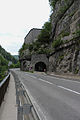
At the fortifications on Pass Lueg
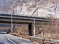
Junction with the Tauern Autobahn (A10)


Web links
Individual evidence
- ^ Federal law of July 8, 1921, regarding federal highways. Federal Law Gazette No. 387/1921.
| B159 | Like the other former federal highways, Salzachtal Straße was part of the federal administration. Since April 1, 2002, it has been under state administration and continues to have the B in the number, but not the name Bundesstraße. |