Bermering
| Bermering | ||
|---|---|---|

|
|
|
| region | Grand Est | |
| Department | Moselle | |
| Arrondissement | Sarrebourg-Château-Salins | |
| Canton | Le Saulnois | |
| Community association | Saulnois | |
| Coordinates | 48 ° 56 ' N , 6 ° 43' E | |
| height | 229-282 m | |
| surface | 5.73 km 2 | |
| Residents | 225 (January 1, 2017) | |
| Population density | 39 inhabitants / km 2 | |
| Post Code | 57340 | |
| INSEE code | 57065 | |
 St. Martin Church |
||
Bermering (German Bermeringen ) is a French commune with 225 inhabitants (as of January 1, 2017) in the Moselle department in the Grand Est region (until 2015 Lorraine ). It belongs to the arrondissement of Sarrebourg-Château-Salins , to the canton of Le Saulnois and to the communal association Communauté de communes du Saulnois .
geography
Bermering is located in Saulnois , 10 kilometers west of Albestroff at an altitude between 229 and 282 meters above sea level, the mean height is 260 meters. The municipal area covers 5.73 square kilometers.
history
Bermering was first mentioned in 927 as Vermeringa in pago Salminsi in the copial book of the Abbey of Sankt Arnulf in Metz . In 1034 it was mentioned there as a Bermeringe . The Abbeys of Saint Arnulf and Saint-Martin de la Glandière in Longeville-lès-Saint-Avold owned land in Bermering. The village was divided between the castellany of Haboudange and the Bailliage of Morhange . From 1751 it was partly part of the Dieuze Bailliage .
In 1793 Bermering received the status of a municipality in the course of the French Revolution and in 1801 the right to local self-government. From 1801 to 1871 it belonged to the former Meurthe department , which was renamed the Meurthe-et-Moselle department in 1871 . In 1871 the community was incorporated into the newly created realm of Alsace-Lorraine of the German Empire due to changes in territory due to the course of the Franco-German War (1870–1871) . The realm of Alsace-Lorraine existed until the end of the First World War (1914–1918) and was then annexed to France. Bermering was in the Moselle department at that time, this change was retained in 1918 when Moselle was finally re-assigned to France.
Population development
| 1962 | 1968 | 1975 | 1982 | 1990 | 1999 | 2007 |
|---|---|---|---|---|---|---|
| 289 | 305 | 288 | 285 | 233 | 223 | 238 |
coat of arms
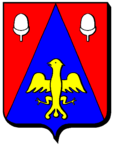
The municipality's coat of arms reminds of the two abbeys that owned lands in Bermering. It is blue with a golden eagle that represents the Abbey of Saint Arnulf. The eagle's wings are spread. Around the eagle is a red chape (two triangles that surround a point like a cloak ) on which there are two silver acorns , which stand for the Abbey of Saint-Martin de la Glandière. Gland is the French word for "acorn".
Web links
- Bermering on annuaire-mairie.fr in French
Individual evidence
- ↑ a b http://genealogie-lorraine.fr/info/blasons_57.php?blason=BERMERING ( Memento of November 13, 2008 in the Internet Archive ) (French) Retrieved March 6, 2010
- ↑ Bermering on quid.fr ( Memento of the original from September 20, 2009 in the Internet Archive ) Info: The archive link was inserted automatically and has not yet been checked. Please check the original and archive link according to the instructions and then remove this notice.
- ^ Henri Lepage: Dictionnaire topographique du département de la Meurthe . In: Société d'archéologie lorraine et du Musée historique lorrain (ed.): Dictionnaire topographique de la France . 18th edition. tape 18 , no. 14 + 63 . Imprimerie impériale, Paris 1862, p. 15 + 42 + 95 ( in Google Books [accessed March 6, 2010]). (French)
- ↑ Bermering on cassini.ehess.fr (French). Retrieved March 6, 2010
