
Poel
| coat of arms | Germany map | |
|---|---|---|

|
Coordinates: 54 ° 0 ' N , 11 ° 26' E |
|
| Basic data | ||
| State : | Mecklenburg-Western Pomerania | |
| County : | Northwest Mecklenburg | |
| Height : | 8 m above sea level NHN | |
| Area : | 36.24 km 2 | |
| Residents: | 2463 (Dec. 31, 2019) | |
| Population density : | 68 inhabitants per km 2 | |
| Postal code : | 23999 | |
| Area code : | 038425 | |
| License plate : | NWM, GDB, GVM, WIS | |
| Community key : | 13 0 74 035 | |
| Community structure: | 15 districts | |
| Address of the municipal administration: |
Community center 13 23999 Insel Poel |
|
| Website : | ||
| Mayoress : | Gabriele Richter (independent) | |
| Location of the municipality of Insel Poel in the district of Northwest Mecklenburg | ||
  |
||

The island of Poel [ pøːl ] is located near Wismar in the Wismar Bay in the Baltic Sea . It has been part of the Hamburg metropolitan region since 2012 .
The non-governmental municipality of Insel Poel includes the island and the island of Langenwerder in the northeast . It belongs to the district of Northwest Mecklenburg in Mecklenburg-Western Pomerania. In 1997 the island of Poel became a state-approved resort, since 2004 the municipality has been known as the Ostseebad.

geography
Geographical location
The main town of the municipality is Kirchdorf at the end of the Kirchsee Bay, which cuts deep from the south . In addition to the Wismar Bay in the south, the island is separated from the mainland in the east by the Zaufe and Breitling and in the northeast by the keel . With an area of 34.3 km², the island is the seventh largest German island.
Poel is connected to the mainland (community Blowatz , district Groß Strömkendorf) via a navigable dam .
Community structure
The municipality of Insel Poel consists of 15 districts (population: as of 2016 :):
|
|
|
history

Surname
The name Poel is probably derived from the old Norse Phol , which in Germanic mythology represents the god of light. The name Poel could also be derived from the Slavic term for “flat field”.
12th century to the Thirty Years War
In 1163, Poel was first mentioned in a document from Archbishop Hartwig of Bremen by confirming the donation of the tithe of the entire island and the town of Fährdorf . The donation was confirmed by Emperor Barbarossa in 1173. Already in 1210 the tithe was divided between the Mecklenburg dukes and the Lübeckers . Around 1210 Heinrich Borwin I of Mecklenburg brought German settlers to the island. During this time, construction began on the Kirchdorfer village church , which was built in four stages and completed around 1350. According to Bernhard Latomus , the Knights of Pfuel (Poele) settled on Poel around 1170. In 1229 a Berent, in 1247 an abbot from Pfuͤle Johann I of Mecklenburg "gloriously introduced". Around 1316 the Holstein monastery of Cismar acquired land on the island of Poel in addition to free float around Wismar. In Westergollwitz there were fourteen hooves from 1321 to 1328, seven hooves in Ostergollwitz from 1316 to 1328, nine hooves in Vorwerk from 1321 to 1329 and seven hooves in Malchow from 1321 to 1329. In 1318 the duke sold the entire island and seven villages on the mainland to the knights of Plessen , Preen and Stralendorff . In 1344 the Lübeck Holy Spirit Hospital acquired the villages of Seedorf, Brandenhusen, Weitendorf and Wangern. In 1614, construction work began on the Poel fortress and castle. The client was Duke Adolf Friedrich I , who in 1598, after a long-term dispute with the Lübeck cathedral chapter, acquired its land on the island and then in 1615 also the goods of the von Stralendorff family. Under the guidance of the general builder and engineer Gerhart Evert Pilooth , an imposing structure was created.
Thirty Years War and Sweden Time

By 1618 the construction work was largely completed. In June 1620, King Gustav II Adolf of Sweden met with Duke Adolf Friedrich I at Poeler Castle. Two months later, the king's bride, Princess Maria Eleonora of Brandenburg , was welcomed by the Mecklenburg duke with a festive service in the church and with festivities in the castle on her way to the wedding in Stockholm on the island of Poel. In 1627, Danish troops retreating from Mecklenburg occupied the Poeler fortress for a short time. In 1628 imperial troops marched into the country under Wallenstein . When the Mecklenburg dukes took possession of the Poeler Castle again in 1631, they found it devastated. It was repaired again, but it was occupied by the Swedes as early as 1635 after Mecklenburg had made peace with the emperor . In 1638 imperial troops occupied the fortress again. When Mecklenburg signed the Peace of Westphalia in 1648 , the island of Poel (with the exception of the hospital villages Wangern and Golwitz) became a Swedish imperial fief for the next few centuries, albeit repeatedly from Brandenburgers (1675), Danes (1711), Prussians and Hanoverians (1716) occupied. During the Seven Years' War (1756–1763) the Prussians passed by several times and plundered. Since the Swedes expanded the neighboring city of Wismar into a fortress from 1648 onwards , they were not interested in the Poeler fortress and let the castle fall into disrepair. In December 1703 a hurricane caused the castle tower to collapse. A few decades later, the castle was only a ruin. In the 19th century the Poeler were allowed to use the ruins as a quarry.
19th century until today
In 1803 Duke Friedrich Franz I paid a loan of 1.25 million Reichstalers to Sweden and got the rights to Poel back for 99 years on the basis of the Malmö pledge agreement . In the Reichsdeputationshauptschluss of 1803 he also received the Lübeck hospital villages.
In 1903 the Swedish crown waived the redemption of the pledge, and Poel returned to Mecklenburg. There has been a fixed road connection to the mainland since 1927. Administratively, Poel belonged to the Wismar-Poel-Mecklenburg-Redentin office in the Duchy of Mecklenburg-Schwerin .


The Vorwerk manor was built around 1880, the two-story Wangern manor around 1911 in Art Nouveau style (today the Steinhagen holiday residence).
On May 3, 1945, Soviet troops replaced the British units from Poel. On the same day, British fighter pilots sank the Cap Arcona and three other ships carrying over 7,000 concentration camp prisoners . 28 of them were washed up dead on Poel beaches. After the end of the war Poel belonged to the Soviet occupied zone of Germany, from 1949 to the German Democratic Republic .
After the fall of the inner-German border, the community round table was set up on December 19, 1989 in Kirchdorf . In May 1990, the first democratic elections for community council took place.
From 1952 to 1994 the community belonged to the Wismar-Land district (until 1990 in the GDR - Rostock district , then in the state of Mecklenburg-Western Pomerania). Due to the district reform in 1994 , the community was incorporated into the district of Northwest Mecklenburg.
Population development
In 1946 the population of Poel reached its high point with over 5100 inhabitants due to refugees from the former German eastern areas after 1905 inhabitants in 1939. Since 1990 the number of inhabitants has been declining.
|
|
Status: December 31 of the respective year
politics
Community representation
The election for the municipal council on May 26, 2019 led to the following result with a turnout of 61.6% (2014: 52.4%):
| Party / list | Share of votes | Seats | +/- |
|---|---|---|---|
| Poeler for Poel | 43.2% | 6th | + 2 |
| CDU | 22.1% | 3 | ± 0 |
| SPD | 15.2% | 2 | ± 0 |
| Individual applicant Sandra Mirow | 7.0% | 1 | + 1 |
| The left | 5.9% | 1 | ± 0 |
| 3 individual applicants together | 6.6% | - | - 3 |
| total | 100% | 13 | ± 0 |
The chairman of the municipal council is Bodo Köpnick.
mayor
- 1991-2004: Dieter Wahls (CDU)
- 2005–2012: Brigitte Schönfeldt (SPD)
- since 2012: Gabriele Richter (independent)
Richter was elected in the mayoral election on November 4, 2018 with 62.2% of the valid votes for a further seven-year term.
coat of arms
|
|
Blazon : “Divided by a golden thread; above in blue a fully sailed silver Zeesenboot; below in green a golden rapeseed blossom. "
The coat of arms and the flag were designed by Joachim Saegebarth from Kirchdorf . It was approved on September 16, 1993 by the Ministry of the Interior and registered under the number 175 of the coat of arms of the state of Mecklenburg-Western Pomerania. |
| Reasons for the coat of arms: In the coat of arms the thread is supposed to symbolize the Baltic Sea beach. While the Zeesenboot refers to the traditional fishing that was practiced with this type of boat until the 1960s, the rape blossom stands for agriculture, especially for rape breeding founded in 1897. |
flag

The flag was approved by the Ministry of the Interior on September 29, 1993.
The flag is evenly striped lengthways with blue, yellow and green. In the middle of the yellow stripe, one fifth of the height of the blue and green stripes, is the municipal coat of arms. The length of the flag is related to the height as 5: 3.
Official seal
The official seal shows the municipal coat of arms with the inscription "GEMEINDE OSTSEEBAD INSEL POEL".
Parish partnership
Poel's partner municipality has been Hammarö in Sweden since 2003 .
Sights and culture

Kirchdorf village church
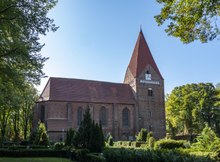
The church in Kirchdorf was probably built in four or five stages between 1210 and around 1350. There are several indications that the tower, built in Romanesque style , is the oldest part of the church and, in addition to its function as a space for church services, also served as a refuge, store, observation tower and bell tower. The first nave in the Romanesque style was added to the tower, probably around 1230/40, and the choir about fifty years later. With its 47 meters height, the tower is a point on the island that can be seen from afar. There are two winged altars from the 15th century in the church. The church organ was acquired from Neukloster in 1704 . Your prospectus dates from the 17th century, the work was renewed by Friedrich Albert Mehmel in 1875 and completely overhauled in 1968. In 1936 Richard Schwarz built a model of a Zeesen boat that has been standing on the north wall of the church ever since. In addition to the church services in summer, concerts are also held in the church.
Castle wall
The castle wall is the remnant of the ramparts. In 1614, construction work began on the Poel fortress and castle. Under the guidance of the general builder and engineer Gerhart Evert Pilooth , an imposing structure was created, consisting of two parts: the castle complex in the form of a five-pointed star and the so-called "Hornewerck" in the form of a star tail, where the church, soldiers' quarters, the captain's apartment and stables are located, surrounded by a system of moats and eleven meter high earth walls.
The castle fell into disrepair after the Thirty Years War . In the 19th century the last remains were removed, only the foundations of the buildings remained. A model of the castle is in the local history museum.
Local museum
In the local history museum of the island of Poel near the community center in the center of Kirchdorf, the life and development of the island are presented on 250 m². Both the geological and the historical development are presented. There are also changing special exhibitions.
Memorial to the dead of the Cap Arcona
Between 1946 and 1950 a memorial for the dead of the Cap Arcona was laid out in the Schwarzer Busch part of the municipality in the north of the island , which commemorates the 28 dead prisoners from the Neuengamme concentration camp (according to other information: from the Stutthof concentration camp ) that washed up after the ship's sinking . In 1979 the memorial was redesigned. The local history museum provides information about the circumstances of this ship tragedy in an exhibition.
Lighthouses

There are two lighthouses on Poel in Timmendorf and Gollwitz. There is also a beacon in Gollwitz . All beacons are used for navigation when entering Wismar .
An iron lattice tower stood near Gollwitz from 1929. In 1953 it was replaced by a 7.6 meter high reinforced concrete tower about one kilometer west of the town on the north coast of Poel. 1956 was there leading lights of the Great Plain installed that was replaced in 1996 by a made as a precision sector leading light fire. It is a common mode fire ( Iso / Glt. 4 seconds) with narrow white, red and green sectors and a range of 8.1 to 6.5 nautical miles .
The beacon, which was originally located in the same tower, has been shining on a 23-meter-high steel lattice mast since 1996, which is located a little west of the building on the beach. It reaches ranges of 7.7 to 6.1 nautical miles for the white, red and green sectors and shows a fire that is interrupted every five seconds ( Oc / Ubr. 5 sec).
beaches


- Sandy beaches with parking facilities, sanitary facilities and snack bars are located in Timmendorf Strand, on the Schwarzen Busch and in Gollwitz.
- Other natural beaches can be found on the stretch of coast between Timmendorf and Am Schwarzen Busch. The beaches have no parking spaces, toilets or snacks.
- There is a nudist beach in Wangern. Parking spaces are available, but sanitary facilities and snack bars are not available.
Events
In addition to natural history events, numerous concerts, exhibitions, readings, slide shows, festivals and children's events take place, especially in summer. A special highlight is the historic Sweden Festival in summer, which is celebrated around the church in Kirchdorf.
Since 2017, the Mudder Island cross -country obstacle course has been held every year in late summer . In 2019 around 1,200 people took part.
Economy and Infrastructure


Agriculture
In 1897 the farmer's son Hans Lembke from Poel founded a seed breeding company in Malchow. In 1953 the first agricultural production cooperative (LPG) was established. In 1968 a trout breeding station in Niendorf delivered 500 tons of annual production. From 1972 the nationally owned Gut Insel Poel (VEG) managed the entire arable land on the island. The cultivation of plants mainly served to propagate seeds. The rapeseed varieties bred on Poel covered around 75% of the GDR's seed needs.
In 1992 the grandchildren of the seed breeding founder Hans Lembke bought back the parent company.
In 2002 Peter Lüth received the German Environment Prize for the development of biological pesticides with his Malchow company Prophyta .
traffic

Poel is connected to the mainland by a dam over which the state road 121 runs. The Mecklenburg transport company (mvb) uses this road to connect the island with Wismar several times a day with bus routes 230 and 430 . Stops are in Fährdorf, Malchow, Gollwitz, Kirchdorf, Weitendorf, Wangen and Timmendorf. In summer, the bus also serves stops in Schwarzer Busch.
Poel has three harbors: Kirchdorf, Niendorf and Timmendorf-Strand. While the port of Kirchdorf is connected to Wismar about three times a day from May to September by a small passenger ship (travel time one hour), the port of Timmendorf-Strand is mainly used for fishing. All ports also have berths for pleasure craft.
The sea rescue boat Wolfgang Wiese of the DGzRS , which has a crew of around 20 volunteer rescue men , is located at the pilot bridge in the port of Timmendorf-Strand .
health
In 1994, the Baltic Sea Clinic for mother-child cures was established on the Schwarzen Busch.
freetime and sports
On the beaches, volleyball can be played on public facilities. The following sports are also offered:
- Archery and tennis in Gollwitz
- Sailing Club Insel Poel
- Football in Kirchdorf at Poeler SV 1923
- Riding and shooting in the shooting range Am Kickelberg
- Golf, bowling, mini golf at the Schwarzen Busch and Timmendorf beach
- Kitesurfing , windsurfing and catamaran sailing on Timmendorfer Strand
Personalities
Sons and daughters of the church
- Ernst Susemihl (1807–1863), translator, born in Kirchdorf
- Georg Calsow (1857–1931), Lord Mayor of Göttingen , born in Timmendorf
- Hans Lembke (1877–1966), plant breeder, born in Malchow
- Gertrud Schröder-Lembke (1908–2006), agricultural historian, born in Malchow
- Martin Kelm (* 1930), designer, born in Neuhof
Personalities associated with the island of Poel
- Hermann Klendenst († 1338), merchant, landowner on the island of Poel
- Karl Christian Klasen (1911–1945), painter, lived in Kirchdorf
- Barbara Kühl (* 1939), writer, grew up on the island of Poel
- Eberhard Klunker (* 1952), guitarist, fled the GDR from the island of Poel in 1975 in a rubber dinghy
literature
- Fritz Meyer-Scharffenberg : Wismar, the island of Poel and the Klützer angle. Hinstorff, Rostock 1965 (3rd, modified edition, ibid 1990, ISBN 3-356-00340-2 ).
- Friedrich Wigger : The Pöl Fortress. In: Yearbooks of the Association for Meklenburg History and Antiquity. Vol. 48, 1883, ISSN 0259-7772 , pp. 1-53, ( digitized ).
- Thorsten Müller: Poel - island and sea. Edition Insight, Berlin 2010, ISBN 978-3-00-030398-2 (photo book).
- Joachim Saegebarth, Heinrich Baudis, Gertrud Schröder-Lembke: Poel island - contributions on landscape and history . Verlag Koch & Raum Wismar OHG, Wismar 2007, no ISBN
Web links
Individual evidence
- ↑ Statistisches Amt MV - population status of the districts, offices and municipalities 2019 (XLS file) (official population figures in the update of the 2011 census) ( help ).
- ↑ Main statutes of the municipality of Insel Poel, § 2 (PDF)
- ↑ Districts & population
- ^ Paul Kühnel: The Slavic place names in Meklenburg. In: Yearbooks of the Association for Mecklenburg History and Archeology. Vol. 46, 1881, ISSN 0259-7772 , pp. 3-168, here p. 108.
- ↑ Latomus, Bernhardus, 1560–1613: Jump in the clock and beginning of the knighthood, which was honored in the past, and hence the compturia that emerged. Item Kurtze Description and regular StamRegiester of all and every deceased and still living old and new nobility and knighthoods established in the land of Stargardt / with great staff / diligence and work from their and other written monuments, also from oral reports; Waiter, Stettin, 1619, page 154 . Retrieved May 25, 2019.
- ^ Anna-Therese Grabowsky: The Cismar Monastery. Neumünster 1982 ISBN 3-529-02180-6 pp. 34-35.
- ↑ Michael Rademacher: German administrative history from the unification of the empire in 1871 to the reunification in 1990. City and district of Wismar. (Online material for the dissertation, Osnabrück 2006).
- ↑ Population development of the districts and municipalities in Mecklenburg-Western Pomerania (Statistical Report AI of the Statistical Office Mecklenburg-Western Pomerania)
- ↑ Result of the election for community council on May 26, 2019 , accessed on January 20, 2020
- ↑ Mayor of the island of Poel on www.poel-ahnen.de
- ↑ Main statute of the municipality of Insel Poel, § 9 (PDF)
- ^ Result of the mayoral election on November 4, 2018
- ↑ Gabriele Richter remains mayor. In: Ostsee-Zeitung , November 4, 2018.
- ↑ Hans-Heinz Schütt: On shield and flag - the coats of arms and flags of the state of Mecklenburg-Western Pomerania and its municipalities . Ed .: production office TINUS; Schwerin. 2011, ISBN 978-3-9814380-0-0 , pp. 166/167 .
- ↑ a b main statute § 1 (PDF).
- ^ Website of the Lübeck Waterways and Shipping Office (accessed June 30, 2013)
- ↑ Kerstin Schröder: Extreme run on Poel: 1200 people fight their way through mud and mega obstacles. In: Ostsee-Zeitung. September 8, 2019, accessed September 8, 2019 .

Ahrendsberg | Balmer Werder | Barther Oie | Baumwerder | Beuchel | Buck | Bull reef | Böhmke | Brinkenberg | Dänholm (near Kröslin) | Dänholm (near Stralsund) | Ferry Island | Fehmarn | Gänsewerder | Görmitz | Greifswalder Oie | Big Werder | Big Wotig | Grot Deil | Hay meadow | Hiddensee | Kastenwerder | Kiel place | Kirr | Small pipe plan | Little Werder | Little Wotig | Little Werder | Kohlhof Island | Koos | Langenwerder | Dear | Liebitz | Moravia | Oe | Poel | Prosnitzer Werder | Riems | Riether Werder | Reefbrink | Ruden | Rügen | Tedingsinsel | Tollow | Ummanz | Urkevitz | Usedom | Vilm | Bird Island | Whale | Warder | Willow tail | Werder | Wührens

Alt Meteln | Bad little ones | Barnekov | Benz | Bernstorf | Bibow | Blowatz | Bobitz | Boiensdorf | Boltenhagen | Brüsewitz | Carlow | Cramonshagen | Dalberg-Wendelstorf | Damshagen | Dassow | Dechow | Mecklenburg village | Dragun | Gadebusch | Gägelow | Glasin | God's gift | Grambov | Grevesmühlen | Greaves | Large Molzahn | Big Stieten | Hohenkirchen | Tall beasts | Holdorf | Hornstorf | Poel Island | Jesendorf | Kalkhorst | Klein Trebbow | Klütz | Kneese | Koenigsfeld | Krembz | Krusenhagen | Lübberstorf | Luebow | Lübstorf | Lüdersdorf | Lützow | Menzendorf | Metelsdorf | Mills Eichsen | Neuburg | Neukloster | Passee | Perlin | Pingelshagen | Pokrent | Rehna | Rieps | Roduchelstorf | Roggendorf | Rye peat | Rögnitz | Rüting | Schildenal | Schlagsdorf | Schoenberg | Seehof | Selmsdorf | Siemz-Niendorf | Stepenitztal | Testorf-Steinfort | Thandorf | Upahl | Utecht | Veelböken | Ventschow | Warin | Warnow | Wedendorfersee | Wismar | Zickhusen | Zierow | Zurow | Züsow