
Lafrimbolle
| Lafrimbolle | ||
|---|---|---|

|
|
|
| region | Grand Est | |
| Department | Moselle | |
| Arrondissement | Sarrebourg-Château-Salins | |
| Canton | Phalsbourg | |
| Community association | Sarrebourg Moselle Sud | |
| Coordinates | 48 ° 36 ' N , 7 ° 1' E | |
| height | 285-440 m | |
| surface | 10.72 km 2 | |
| Residents | 202 (January 1, 2017) | |
| Population density | 19 inhabitants / km 2 | |
| Post Code | 57560 | |
| INSEE code | 57374 | |

Lafrimbolle is a French commune with 202 inhabitants (as of January 1, 2017) in the Moselle department in the Grand Est region (until 2015 Lorraine ).
geography
The municipality of Lafrimbolle is located in the foothills of the Vosges on the border with the Meurthe-et-Moselle department , about 18 kilometers south of Sarrebourg . The White Saar flows through the municipality , the core town is in a side valley of the river.
The majority of the municipality consists of forest, the northern half is covered by the Bois de la Neuve Grange ( Neuscheuer Forest ), and in the south is the Forêt des Marches dite Forêt de la Comtesse . The hamlet of Les Harcholins ( Harschlingen ) , located south of the core town, belongs to Lafrimbolle .
history
In 1361 the place was mentioned as Lauffenborn . After the Franco-Prussian War he found himself on the German side of the new border, a border crossing was built and the place was renamed Lascemborn ; In 1915 this was changed in Lassenborn , in November 1918 the village was returned to France.
Population development
| year | 1962 | 1968 | 1975 | 1982 | 1990 | 1999 | 2007 | 2015 |
| Residents | 214 | 176 | 159 | 147 | 184 | 198 | 221 | 207 |
Culture and sights
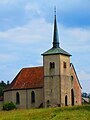
Saint-Michel church
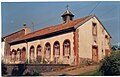
Protestant Church

