
Řikonín
| Řikonín | |||||
|---|---|---|---|---|---|
|
|||||
| Basic data | |||||
| State : |
|
||||
| Region : | Jihomoravský kraj | ||||
| District : | Brno-venkov | ||||
| Area : | 261 ha | ||||
| Geographic location : | 49 ° 22 ′ N , 16 ° 18 ′ E | ||||
| Height: | 355 m nm | ||||
| Residents : | 46 (Jan 1, 2019) | ||||
| Postal code : | 594 51 | ||||
| License plate : | B. | ||||
| traffic | |||||
| Street: | Dolní Loučky - Žďárec | ||||
| Railway connection: | Brno -Havlíčkův Brod | ||||
| structure | |||||
| Status: | local community | ||||
| Districts: | 1 | ||||
| administration | |||||
| Mayor : | Petr Bytešník (as of 2018) | ||||
| Address: | Řikonín 16 594 51 Křižanov |
||||
| Municipality number: | 596698 | ||||
| Website : | www.rikonin.cz | ||||


Řikonín (German Rikonin , formerly Rzikonin ) is a municipality in the Czech Republic . It is located nine kilometers west of Tišnov and belongs to the Okres Brno-venkov .
geography
Řikonín is located in the Bohemian-Moravian Highlands on the left side of the Libochovka in a small side valley. The Chochol (512 m) rises to the southwest. The Brno-Havlíčkův Brod railway line runs north of the village.
Neighboring towns are Tišnovská Nová Ves , Skryje , Boudy and Vrbka in the north, Kaly in the north-east, Újezd u Tišnova in the east, Chytálky and Falcov in the south-west, Kuřimské Jestřabí and Kuřimská Nová Ves in the south, Kutiny and Lubnéín in the south-west and Rojetín in the south-west in the north-west.
history
The village was first mentioned in writing in 1230.
After the abolition of patrimonial Řikonín formed from 1850 a municipality in the Brno district and judicial district Tischnowitz . Since 1896 the community belonged to the newly formed district of Tischnowitz. Between 1939 and 1953 the double-track railway line from Brno to Havlíčkův Brod was built above the village . At the end of the Second World War, a prisoner-of-war camp was set up in Kutiny, whose inmates had to work in the subterranean aircraft manufacturing facilities under the code name Diana . The barracks of the Kutiny camp were converted into recreational facilities after the end of the war. After the dissolution of the Okres Tišnov, the village came to the Okres Žďár nad Sázavou at the beginning of 1961 . Since the beginning of 2005 the municipality Řikonín belongs to the Okres Brno-venkov . The parish is the village to the church in Dolní Loučky .
Community structure
No districts are shown for the municipality of Řikonín.
Attractions
- Chapel of St. Aegidius, on the village square
- The pilgrimage chapel of the Virgin Mary, west of the village on a hill, the Madonna of Řikonín inside was created in the 17th century
- Kutiny Railway Viaduct, southwest of Řikonín on Libochovka
photos
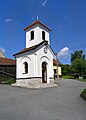
Chapel on the village square
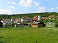
The village


Individual evidence
- ↑ Český statistický úřad - The population of the Czech municipalities as of January 1, 2019 (PDF; 7.4 MiB)
- ↑ http://www.tisnov.cz/deutsch/index.php?page=loucky_zdarec_de ( page no longer available , search in web archives ) Info: The link was automatically marked as defective. Please check the link according to the instructions and then remove this notice.
Web links