
Yverdon-les-Bains
| Yverdon-les-Bains | |
|---|---|
 |
|
| State : |
|
| Canton : |
|
| District : | Jura north vaudois |
| BFS no. : | 5938 |
| Postal code : | 1400 Yverdon-les-Bains 1432 Gressy |
| UN / LOCODE : | CH YLB |
| Coordinates : | 539 009 / 181 170 |
| Height : | 435 m above sea level M. |
| Height range : | 429-572 m above sea level M. |
| Area : | 13.54 km² |
| Residents: | 30,157 (December 31, 2018) |
| Population density : | 2227 inhabitants per km² |
| Unemployment rate : | 5.8% (May 31, 2,015) |
| Website: | www.yverdon.ch |
 Yverdon-les-Bains |
|
| Location of the municipality | |
  |
|

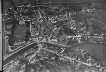
Yverdon-les-Bains is a municipality and capital in the Jura-Nord vaudois district of the canton of Vaud in Switzerland . The city lies on an alluvial plain at the southwestern end of Lake Neuchâtel .
It was not until 1982 that Yverdon was officially renamed Yverdon-les-Bains , which is why the place is often still called Yverdon . The station has the official name, stops within the city bus network are listed in the timetable under Yverdon . During the Roman era the place was called Eburodunum . The former German name Iferten or Ifferten is rarely used today.
Yverdon is an economic, administrative and cultural center in the northern part of the canton of Vaud with numerous cultural events. The Yverdon Castle , a castle of the Dukes of Savoy (13th and 19th century), was from 1805 to 1825 one of Johann Heinrich Pestalozzi led educational institution, now it is a museum. The sulphurous thermal baths of Yverdon have been known since Roman times.
geography
Yverdon is 435 m above sea level. M. , 30 km north of the canton capital Lausanne (linear distance). The city extends on the alluvial plain at the south-western end of Lake Neuchâtel , at the mouth of the Zihl (French: La Thielle ), at the southern foot of the Jura , in the northern Midlands of Vaud .
The area of the 11.3 km² municipal area covers a section of the Vaud Central Plateau. The main part of the municipality is occupied by the flat alluvial plain of the Thielle (northeasternmost part of the Orbe plain ). In the urban area, five canalized rivers flow into Lake Neuchâtel. From south to north these are the Buron , the Canal Oriental , the Thielle, the Mujon and the Bey , which also form the northern border. Yverdon is not located directly on the lake, but behind the edge of the bank, which is partly used for sports and leisure facilities (exhibition area of Expo.02 ), and partly as a nature reserve with reeds and forest. To the south-west, the communal soil extends into the intensely agriculturally used plain on both sides of the Thielle. In the south and south-east, Yverdon is part of the western slope of the Montéla , which is 570 m above sea level. M. the highest point of the urban area is reached. In 1997, 53% of the municipal area was in settlements, 8% in forests and woodlands, 35% in agriculture and a little more than 4% was unproductive land.
Yverdon-les-Bains includes extensive residential areas on the western slope of Montéla, several commercial and industrial zones as well as a few individual courtyards on the plain southwest of the city. Since July 1, 2011, the town of Gressy , also in the south, has also been part of Yverdon-les-Bains. Yverdon's neighboring communities are Cheseaux-Noréaz , Cuarny , Pomy , Belmont-sur-Yverdon , Ependes , Treycovagnes and Montagny-près-Yverdon .
population
| Population development | |
|---|---|
| year | Residents |
| 1803 | 2500 |
| 1850 | 3619 |
| 1900 | 7985 |
| 1910 | 8634 |
| 1930 | 9715 |
| 1950 | 12,266 |
| 1960 | 16,338 |
| 1970 | 20,538 |
| 1980 | 20,802 |
| 1990 | 22,758 |
| 2000 | 24,376 |
With 30,157 inhabitants (as of December 31, 2018), Yverdon is the second largest municipality in the canton of Vaud after Lausanne. 82.6% of the residents speak French, 3.9% speak Serbo-Croatian and 3.5% speak Portuguese (as of 2000). The population of Yverdon has increased steadily over the past two centuries. The greatest increase in population with over 60% was registered between 1950 and 1970. Around 32% of the population are foreigners.
politics
Municipal Parliament
The legislative authority is the communal council ( conseil communal ) elected every four years by the voters of the commune of Yverdons-les-Bains . The 100 MPs are elected by proportional representation. The tasks of the municipal parliament include budget and invoice approval, the establishment of municipal regulations and control of the executive. The distribution of seats in the 2016 elections was as follows:
- FDP.The Liberals : 40 seats
- SP : 30 seats
- GPS : 15 seats
- SVP : 15 seats
National Council elections
In the Swiss parliamentary elections 2019, the share of the vote in Montreux was: Greens 25.1%, SP 25.0%, FDP 17.0%, SVP 16.3%, glp 5.5%, POP / Sol 3.9%, EPP 2.1%.
economy
Yverdon is an important regional economic and administrative center. Around 1% of the workforce is still employed in the primary sector, 34% in the secondary sector and 65% in the service sector.
The Agriculture focuses on the fertile flood plain on both sides of Thielle southwest of the city. Grain, sugar beet and rapeseed are grown on the arable land. In addition, thanks to the mild and sunny climate, there are extensive vegetable crops.
The development into an industrial location took place with the connection of Yverdon to the Swiss railway network in the middle of the 19th century. The city has been the location of the central workshops of the SBB since 1853. The workshops of Paillard-Bolex were founded in 1814, the successor of which was Hermes Precisa International (1974–1989). Leclanché SA , founded in 1909, achieved international fame and produced the first usable galvanic dry elements (batteries) in series.
Today the regionally important metal, machine and cigar industry has its headquarters in Yverdon. In addition, companies in electrical engineering, precision mechanics, information technology, construction and the food industry as well as many other smaller companies (more than 500 in total) have settled. The commercial and industrial zones of Yverdon are located near the train station and on the western and southern outskirts. The Chamard commercial zone on the north-western outskirts with shopping centers and numerous leisure and sports shops already belongs to the municipality of Montagny-près-Yverdon .
Yverdon is the location of the city and district administration, many banks and insurance companies as well as a publishing house. In 1986 the Y-Parc was founded, a science and technology park that advises and supports companies in the start-up phase and promotes innovative projects in research and marketing.
tourism

Thanks to the thermal baths, which were already used by the Romans, Yverdon-les-Bains is a major attraction for spas and bathers. The first heyday of modern spa tourism occurred in the 18th century with the building of the Hôtel des Bains. Another boom came at the end of the 19th century when hydrotherapy became fashionable. During this time, the construction of a new thermal building (1887) and the Rotonde in the typical sophisticated architectural style took place.
After the importance of Yverdon as a bathing resort had declined somewhat in the first half of the 20th century, a new phase of development followed with the construction of the modern thermal center in 1977 and the inauguration of the large open-air thermal bath in 1983. With the renaming of Yverdon to Yverdon-les-Bains in 1981 Beach tourism was also marketed internationally.
The sights of the old town, the museums and the location on the lake also attract numerous tourists. In 2002 Yverdon-les-Bains was the location of one of the five Arteplages of the Swiss national exhibition Expo.02 , which helped the city to a further tourist boom. One of the main attractions and landmarks of Yverdon was Le Nuage (The Cloud), a steel frame standing in Lake Neuchâtel, which, with over 30,000 tiny nozzles, produced a cloud that visitors could enter. In the meantime, the construction (along with the other exhibits) has been canceled again.
traffic

Yverdon-les-Bains is a major traffic junction at the southwest end of Lake Neuchâtel. It is on the main road 5 from Lausanne to Neuchâtel and is the starting point for other important roads to Estavayer-le-Lac , Moudon , Orbe and Sainte-Croix . The city is also on the A1 motorway , the main Swiss axis through the Central Plateau from Geneva to St. Gallen . The Lausanne – Yverdon section with the Yverdon-Sud connection was opened in 1981, and the continuation towards Bern was opened to traffic in 2001. The A5 has been branching off from the A1 since 1984 and crosses the Yverdon plain with a 3 km long bridge.
Yverdon was connected to the railway network on May 7, 1855 with the opening of the railway line to Bussigny-près-Lausanne . On November 7, 1859, the line to Neuchâtel and on February 1, 1877 the line to Payerne went into operation. The narrow-gauge railway Yverdon – Ste-Croix (YSteC) was finally inaugurated on November 27, 1893.

The city bus network of Yverdon and numerous post bus lines, which connect the city with the surrounding area, ensure the fine distribution of public transport. Yverdon also has a connection to the shipping network on Lake Neuchâtel. There is an airfield in the Orbe plain.
education
As an important educational center in the northern part of the canton of Vaud, Yverdon has all school levels up to grammar school. The CESSNOV (Center d'enseignement secondaire supérieur du Nord vaudois), a large school center designed for around 1000 pupils, is located just outside the city limits in the municipality of Cheseaux-Noréaz . There are also numerous cantonal schools in Yverdon, including the Vaudois engineering school (eivd), the vocational school for the northern part of the canton, an industrial foreman school and a technical center.
Culture, museums

- The city has a city library, four museums and two theaters: the Théâtre Benno Besson, which opened in 1898, with 460 seats and the Théâtre de l'Echandole in the castle basement.
- The local history museum (Musée d'Yverdon) is located in the castle . It was founded in 1761 as one of the oldest museums in the canton. In its local history and ethnographic collection it shows important finds from 6000 years up to the Celtic and Roman epoch. The vaults of the castle house an exhibition on the topic of "Shipping in ancient times". The core consists of two ships from the Roman period found in 1971 and 1984, which are remarkably well preserved.
- The Maison d'Ailleurs (House of Elsewhere) is the only museum for science fiction, utopia and extraordinary journeys in the world. It was launched in 1976 by the writer Pierre Versins . The Maison d'Ailleurs collections consist of tens of thousands of books, comics, toys and works of art.
- There is also the Musée de la Mode and a school and education museum.
Events
In 2005 and 2015 the international robot competition Eurobot took place in Yverdon . In 2005 it was held outside France for the first time since it was founded in 1998.
history
Early history
Around 4000 BC Chr erected. Neolithische settlers chasséen culture in the field of today's Yverdon the Alignement of Clendy at the former mouth of the river Orbe .
In the Iron Age , around 800 BC. BC, Celtic tribes lived in the area of Yverdon and its surroundings , of which the Helvetians are probably the best known. Under the Helvetians, Eburodunos became a trading center thanks to its location: on the one hand it was on the Roman road from Lausanne to Avenches (which connected the Rhone with the Rhine ), on the other hand it was on the main connecting axis from Gaul to Italy .
Roman epoch

It is said of the Romans that the Helvetii destroyed the old Eburodunos and gave it to the flames when they emigrated to Gaul . After the old Helvetia in 58 BC BC was conquered by the Romans , they built a vicus in Yverdon , a military base with soldiers, craftsmen, boatmen and shipbuilders, but also officials and magistrates. The Roman camp was located where the city cemetery is today. The Romans took over the Celtic name of the place and called it from now on Vicus eburodunensis or simply Eburodunum . The Romans were already familiar with the healing properties of the sulphurous thermal springs in front of the city and conducted their water into their city using pipes.
The Roman city itself was not fortified. It was therefore attacked and destroyed by the Alemanni around the year 260 . Yverdon was only rebuilt in 370 - this time as a heavily fortified castrum . It was abandoned by the Romans at the beginning of the 5th century when they ceded the province of Helvetia to the Burgundians.
Burgundy period
From the year 443 Yverdon was under the protection of the Burgundians , who also Christianized it. After that, the city disappeared from the history books for several centuries.
The first documented mention of the place in the Middle Ages took place in 971 under the name in pago everdunense and in 998 Lake Neuchâtel was also called lacus Everdunensis . Later the names Everdun (1228) and Yverdunum (1340) appeared.
In the 9th and 10th centuries, Yverdon was part of the Holy Roman Empire of the German Nation . However, due to the constant feuds and wars between the local feudal lords, there was practically anarchy throughout the region at that time.
Savoy

In 1251 Peter of Savoy inherited the lands and estates of Yverdon from his father-in-law, Aymon de Faucigny . The Petit Charlemagne (“Little Charlemagne”) knew nothing better than to move the people and the city to their current location between the lake and the two rivers. Peter of Savoy fortified the new city and had a city wall and Yverdon Castle built between 1260 and 1272 .
Under Peter of Savoy, Yverdon was granted market rights in 1260 and was given the right to hold a weekly market (every Thursday) and a three-day fair in autumn in 1264 . Yverdon was on the important trade route on the axis between the Lake Geneva basin and Neuchâtel and the plateaus of the Jura . Shipping on the Thielle and Lake Neuchâtel was also important for the city at that time and it had two ports: Gleyre and La Pleine. As a result, Yverdon experienced a significant economic boom at the end of the 13th century.
At the end of the 14th and beginning of the 15th centuries, the first houses were built outside the fortification walls: the Faubourg de la Pleine, the Faubourg de l'Hôpital and the Faubourg des Moulins were built.
Bern period
The peace and prosperity that Yverdon experienced in the Kingdom of Savoy for several centuries came to an end when a new political force emerged: the Swiss. In 1475 the city of Yverdon had to surrender to the federal troops and was then under their occupation. The peace after the battles of Grandson and Murten lasted only a short time until the Bernese armed forces conquered the Vaud. In February 1536, when all other important Vaudois cities had already been conquered, Yverdon still offered resistance, but had to surrender on the night of February 24th to 25th.
Under Bernese rule, the Savoy castle became the residence of the governors. The Bailiwick of Yverdon was much larger than today's district of Yverdon. It reached in the west as far as the French border at Sainte-Croix and Les Clées , in the south almost to Echallens and in the east into the Molasse hill country in the Mentue area.
The Bernese gentlemen brought Protestantism to the previously Catholic city , among other changes . They destroyed the old church that Peter of Savoy had built on the site of the old Roman castrum .
Law and order prevailed in Yverdon under the strict Bernese rule. The old city walls were rebuilt and provided with defensive towers. The Bernese also repaired the bell tower and actively promoted the economy and trade by building commercial buildings and market halls. From the end of the 16th century, the city experienced a further boom with the arrival of Huguenot refugees.
The Bernese occupation had some positive aspects: In addition to economic development, the school system was expanded, new roads were built and old ones improved, and a post office and a stagecoach service were set up. In addition, the Entreroches Canal was built , which was supposed to connect the city with Lake Geneva . Yverdon became the second most important city in Vaud.
enlightenment
Even before the 18th century, Yverdon was known to be open to scientists, philosophers, writers and travelers and to receive them warmly. People from all over Europe traveled to Yverdon to bathe away their various ailments in the sulphurous water of the thermal springs that were expanded in the 1730s.
Yverdon had no fewer than seven printing works in the 18th century. Between 1770 and 1780 a. a. the well-known Encyclopédie d'Yverdon printed. Jean-Jacques Rousseau fled France to Yverdon, to his friend Rougin. From 1730 Yverdon even had a direct shipping line from the port of Gleyre to London .
After the collapse of the Ancien Régime , Yverdon was assigned to the canton of Léman, newly created under the Helvetic Constitution, on January 25, 1798 - as the last city in the Vaud region . This went on in 1803 with the enactment of the mediation constitution in the canton of Vaud. Yverdon has been the capital of the district of the same name since 1798.
19th century
In the 19th century, Yverdon was finally overtaken by the industrial revolution and its aftermath. The city walls were opened and partially torn down. The city administration bought the castle and set up a school in it, in which the well-known Swiss pedagogue Johann Heinrich Pestalozzi taught. His revolutionary methods made Yverdon known far beyond the country's borders. In 1890 a statue was erected in his honor.
In the 1830s, shipping on the Entreroches Canal was discontinued and replaced by a railway line between Yverdon and Lausanne, which opened on May 7, 1855. In the 1860s, city lighting was switched from oil to petrol and then to gas. In addition, new industries shot up and new quarters were built.
Attractions

Yverdon-les-Bains has a picturesque historical townscape. The medieval old town is located between the Thielle and the Canal Oriental. The approximately oval city plan with an extension of about 300 m in length and 200 m in width has a main street as a longitudinal axis, south of it two further longitudinal streets and several cross streets.
At the eastern end of the old town on Pestalozzi Square is Yverdon Castle , a characteristic example of the Carré Savoyard in the form of a four-wing complex, flanked by three smaller round towers and a massive round donjon at the southeast corner. It was built in the 13th century within a few years and since then has undergone numerous redesigns and restorations, especially in the residential wings. The town museum, founded in 1763, is located in the castle. Here are Celtic artefacts , Roman boats and a sarcophagus with the Ptolemaic mummy of Nesshou issued. In the Musée Suisse de la Mode , which is also located in the castle, textile treasures from the period from 1850 to 1960 are on display.
Also on Pestalozzi Square is the Reformed Church of Notre-Dame , which was built between 1753 and 1757 on the site of a previous Gothic building. Facing the square, it was equipped with a striking five-axis Baroque facade with a curved gable. The late Gothic bell tower (1608–1610) and the richly carved choir stalls were taken over from 1499 to 1502 from the previous building.

On the south side of the square, the Hôtel de ville (town hall) was built on the site of the former granary from 1767 to 1773. It has a show facade with a pilaster risalit and triangular gable. Exhibitions on various topics are held here all year round. The Préfecture, the former Hôtel de l'Aigle, from 1776 also dates from the so-called Belle Epoque . The Pestalozzid Monument from 1889 stands on Pestalozzi Square.
Numerous town and patrician houses from the 17th and 18th centuries have been preserved in the old town. There are also other remarkable buildings outside the old town: the casino, built in 1898 in the neo-baroque style, and the neo-renaissance schoolhouse (1897) on the other side of the Place d'Armes. The Villa d'Entremonts is a typical country estate from 1779 in the middle of a park. The Classicist Catholic Church of Saint-Pierre , built between 1837 and 1841, is located on Rue de la Maison-Rouge .
The Alignement von Clendy , a prehistoric stone avenue , is located in a forest clearing on the eastern edge of the city near the main road towards Estavayer-le-Lac . It consists of 45 menhirs and statue menhirs and is the most impressive megalithic complex in Switzerland. The stones were discovered in 1878 as a result of the Jura water correction with lowering of the lake water level, erected in 1975 and the system was restored in 1986.
photos

Room: La Marive
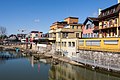
La Thièle

Pestalozzi monument (partial view)


Town twinning
Town partnerships exist between Yverdon-les-Bains and the following cities :
-
 Nogent-sur-Marne in the Île-de-France region (France)
 -
 Winterthur in the Canton of Zurich (Switzerland)
 -
 Prokuplje (Serbia)
 -
 Kagamino (Japan)
 -
Pontarlier in the Bourgogne-Franche-Comté region (France)
-
 Collesano in Sicily (Italy)
Personalities

- Nicolas Doxat (1682–1738), general and fortress builder
- Frederick Haldimand (1718–1791), military officer and governor of Québec
- Johann Heinrich Pestalozzi (1746–1827), teacher, worked in Yverdon from 1804 to 1825
- François Rodolphe de Weiss (1751–1818), politician, writer and officer
- Claude Verdan (1909-2006), surgeon
- Benno Besson (1922–2006), actor, director and theater director
- Rodolphe Kasser (1927–2013), coptologist
- Claire Krähenbühl (* 1942), writer and artist
- Richard Aeschlimann (* 1944), artist
- Ivor Malherbe (* 1962), jazz musician and presenter
- Steve Zacchia (* 1982), racing car driver
- Whitney Toyloy (* 1990), Miss Switzerland 2008
- Mika Domingues (* 1991), Portuguese football player
literature
- Oswald, Franz et al .: Helvéti-Cité: The “Netzstadt Drei-Seen-Land” project. Case study on the urban design of the territory, Zurich 2004 (urban planning, joint project of the cities of Biel, Murten, Neuchâtel and Yverdon-les-Bains to follow up on Expo.02)
- Paul Bissegger: Swiss Art Guide GSK, Volume 540: L'église Saint-Pierre à Yverdon , Bern 1993, ISBN 3-85782-540-5
Web links
|
Further content in the sister projects of Wikipedia:
|
||
|
|
Commons | - multimedia content |
|
|
Wikisource | - Sources and full texts |
- Official website of the city of Yverdon-les-Bains (French)
- Official website of the Yverdon-les-Bains Tourist Office
- Denis Weidmann, Patrick Auderset: Yverdon-les-Bains. In: Historical Lexicon of Switzerland .
- Aerial photos of the city and its surroundings
Individual evidence
- ↑ Permanent and non-permanent resident population by year, canton, district, municipality, population type and gender (permanent resident population). In: bfs. admin.ch . Federal Statistical Office (FSO), August 31, 2019, accessed on December 22, 2019 .
- ↑ Demandeurs d'emploi, chômeurs et taux de chômage par commune. ( XLS , 115 kB) Statistique Vaud, Département des finances et des relations extérieures (Statistics Vaud, Department of Finance and Foreign Affairs), accessed on June 14, 2015 (French).
- ↑ http://www.yverdon-les-bains.ch/fileadmin/documents/Votations_et_elections/2016_Repartition_des_sieges_et_liste_des_elus.pdf
- ^ Federal Statistical Office : NR - Results parties (municipalities) (INT1). In: Federal Elections 2019 | opendata.swiss. August 8, 2019, accessed August 20, 2020 .
- ^ François Marin: Théâtre Benno Besson, Yverdon-les-Bains VD . In: Andreas Kotte (Ed.): Theater Lexikon der Schweiz - Dictionnaire du théâtre en Suisse. Volume 3, Chronos, Zurich 2005, ISBN 3-0340-0715-9 , p. 1901. (French)
L'Abbaye | L'Abergement | Agiez | Arnex-sur-Orbe | Ballaigues | Baulmes | Bavois | Belmont-sur-Yverdon | Bioley-Magnoux | Bofflens | Bonvillars | Bretonnières | Bullet | Chamblon | Champagne | Champvent | Chavannes-le-Chêne | Chavornay | Chêne-Pâquier | Le Chenit | Cheseaux-Noréaz | Les Clées | Concise | Corcelles-près-Concise | Cronay | Croy | Cuarny | Démoret | Donneloye | Ependes | Fiez | Fontaines-sur-Grandson | Giez | Grand event | Grandson | Juriens | Le Lieu | Lignette roll | Mathod | Mauborget | Molondine | Montagny-près-Yverdon | Montcherand | Mutrux | Novalles | Onnens | Orbe | Orges | Orzens | Pomy | La Praz | Premier | Provence | Rances | Romainmôtier-Envy | Rovray | Sainte-Croix | Sergey | Suchy | Suscévaz | Tévenon | Treycovagnes | Ursins | Valeyres-sous-Montagny | Valeyres-sous-Rances | Valeyres-sous-Ursins | Vallorbe | Vaulion | Villars-Epeney | Vugelles-La Mothe | Vuiteboeuf | Yverdon-les-Bains | Yvonand
Former municipalities: Arrissoules | Chanéaz | Corcelles-sur-Chavornay | Envy | Essert-Pittet | Essert-sous-Champvent | Fontanezier | Gossens | Gressy | Mézery-près-Donneloye | Prahins | Romainmôtier | Romairon | Vaugondry | Villars-Burquin | Villars-sous-Champvent
Canton of Vaud | Districts of the canton of Vaud | Municipalities of the canton of Vaud

Four parishes: Bolligen | Vechigen | Stettlen | Muri
Regional courts: Seftigen | Sternenberg | Konolfingen | Zollikofen
Offices: Thun | Zofingen | Aarau | Lenzburg | Brugg | Burgdorf | Büren | Unterseen | Wiedlisbach | Obersimmental | Lower Simmental | Frutigen | Oberhofen | Aigle | Hasli | Trachselwald | Bipp | Aarwangen | Cheeks | Landshut | Lenzburg (Office) | Schenkenberg | Aarberg | Nidau | Erlach | Laupen | Oltigen | Signau | Biberstein | Aarburg | Saanen | Brandis | Interlaken | Königsfelden | Thorberg | Fraubrunnen | Zofingen (pen) | Frienisberg | St. Johannsen | Gottstatt | Buchsee | Sumiswald | Roche (Saline) | Köniz | Kasteln | Hettiswil
Offices in Vaud: Avenches | Moudon | Yverdon | Lausanne | Morges | Nyon | Vevey | Romainmôtier | Oron | Payerne | Bonmont | Aubonne
Common lords with Freiburg: Schwarzenburg | Murten | Grandson | Echallens
Common federal dominions: Baden | Thurgau | Free offices | Rhine Valley | Sargans | Locarno | Lugano | Mendrisio | Valle Maggia
Offices and services in the city of Bern: Bauamt | Salt Directorate | Mushafen | Pen | Corn Office | Big hospital | Inselspital