
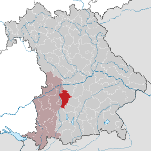
Aichach-Friedberg district
| coat of arms | Germany map |
|---|---|

|

Coordinates: 48 ° 26 ' N , 11 ° 3' E |
| Basic data | |
| State : | Bavaria |
| Administrative region : | Swabia |
| Administrative headquarters : | Aichach |
| Area : | 780.33 km 2 |
| Residents: | 134,655 (Dec. 31, 2019) |
| Population density : | 173 inhabitants per km 2 |
| License plate : | AIC, FDB |
| Circle key : | 09 7 71 |
| NUTS : | DEB3B |
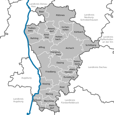
| Circle structure: | 24 municipalities |
| Address of the district administration: |
Münchener Strasse 9 86551 Aichach |
| Website : | |
| District Administrator : | Klaus Metzger ( CSU ) |
| Location of the district of Aichach-Friedberg in Bavaria | |
  |
|


The district of Aichach-Friedberg is the easternmost district in the Bavarian administrative district of Swabia .
geography
location
The district is east of Augsburg ; the border between the two areas is usually formed by the Lech . The most important inner river is the Paar , which crosses the district from southwest to northeast and on which some Friedberg districts and Aichach lie.
The district of Aichach-Friedberg is largely rural, larger cities and communities are Friedberg , Aichach and Dasing and in the south Mering and Kissing .
The district is also known as the Wittelsbacher Land , as the ancestral seat of the Bavarian ruling family of the Wittelsbachers was once here. In Oberwittelsbach , a district of Aichach, the remains of the family castle and a castle church built on the same site can still be viewed today .
Neighboring areas
Starting in a clockwise direction in the northwest, the district borders on the districts of Donau-Ries , Neuburg-Schrobenhausen , Pfaffenhofen an der Ilm , Dachau , Fürstenfeldbruck , Landsberg am Lech and Augsburg as well as the independent city of Augsburg .
history
Until 1800
Archaeological finds show that the district area has been inhabited for at least ten thousand years. Numerous weapons finds indicate that there have often been armed conflicts here.
In Roman times , the district was primarily the “forecourt” for Augusta Vindelicorum , the capital of the province of Raetia . Most of the farms that supplied the capital are likely to have been there, alongside some suburban villas belonging to the wealthy city dwellers.
With the end of Roman rule in Raetia (end of the 5th / beginning of the 6th century), the Alemanni and Bavarians settled in what is now the district. The first written record of a district municipality is Adelzhausen , which is attested in 782 as Adalhemelshusir .
In 1124, Count Otto V. von Scheyern moved his family's ancestral castle from Scheyern near Dachau to Wittelsbach near Aichach. The noble family, henceforth known as Wittelsbacher , gained the ducal dignity of Bavaria in 1180 and ruled the country until 1918. However, the castle itself was razed in 1209, and only a memorial stone reminds of the original building.
Friedberg Castle was built in 1264 to charge a fee for transport across the Lech. Nothing reminds of this castle today either, as the original building burned down in the 16th century.
Due to its border location on the Lech and its proximity to the imperial city of Augsburg, today's district was often the scene of bitter battles. B. 1420, in the Thirty Years' War or in the 18th century under the two Wars of Succession and later the French Revolutionary Wars .
Regional courts
The district area was originally divided into the district courts Aichach , Friedberg and Mering. After the unification of Friedberg and Mering (1799) and the administrative reforms of the early 19th century, Friedberg belonged to the Isarkkreis (capital Munich) from 1817 , Aichach with the neighboring Rain to the Oberdonaukreis (capital Augsburg). In 1837 Friedberg, Aichach and Rain came to Upper Bavaria .
District Offices
Aichach and Rain were combined to form the Aichach district office in 1862, and the Friedberg district office was created from the Friedberg district court.
On the occasion of the reform of the layout of the Bavarian district offices, the district office of Aichach ceded the district court district (also the district) of Rain to the district office of Neuburg an der Donau on January 1, 1880 .
On July 1, 1910, the Friedberg district office ceded the Meringerau (now Siebenbrunn ) community to the city of Augsburg. On January 1, 1913, other parishes came to Augsburg.
On January 1, 1914, the Landsberg am Lech district office handed over the Unterbergen community to the Friedberg district office. Schmiechen followed on January 1, 1915 .
Counties
On January 1, 1939, as everywhere in the German Reich, the designation district was introduced. Thus the district offices became the districts of Aichach and Friedberg .
The Friedberg district was assigned to the Swabian administrative district in 1944 .
Aichach-Friedberg district
On July 1, 1972, as part of the regional reform in Bavaria in the administrative district of Swabia, the new district of Augsburg-Ost with its headquarters in Aichach was formed from the following components :
- All communities in the Upper Bavarian district of Aichach with the exception of the communities Altomünster , Hilgertshausen , Hohenzell , Kiemertshofen , Kleinberghofen , Oberzeitlbach , Randelsried , Stumpfenbach , Tandern , Thalhausen and Wollomoos , which came to the district of Dachau
- All communities in the Friedberg district with the exception of the communities Höfa , Pfaffenhofen an der Glonn , Sittenbach , Unterumbach and Weitenried , which came to the Dachau district
- The communities Baierberg , Eresried , Hausen bei Hofhegnenberg, Hofhegnenberg and Steindorf from the Upper Bavarian district of Fürstenfeldbruck
- The communities Echsheim , Kühnhausen , Reicherstein , Schorn and Wiesenbach from the dissolved Upper Bavarian district of Neuburg an der Donau
- The community of Grimolzhausen from the dissolved Upper Bavarian district of Schrobenhausen
The district council of the new district decided to change its name, so that on May 1, 1973 the district was given its current name, Aichach-Friedberg District .
On January 1, 1994, Baar (Swabia) was spun off from the Thierhaupten municipality in the Augsburg district and raised to a municipality in the Aichach-Friedberg district.
politics
District council
The local elections on March 15, 2020 in the Aichach-Friedberg district led to the following result for the district council:
Election results of the district council elections 2020, 2014 and 2008: in the district of Aichach-Friedberg:
| Parties and constituencies | % 2020 |
Seats 2020 |
% 2014 |
Seats 2014 |
% 2008 |
Seats 2008 |
||
|---|---|---|---|---|---|---|---|---|
| CSU | Christian-Social Union in Bavaria | 41.3 | 25th | 46.9 | 28 | 48.0 | 29 | |
| Green | Alliance 90 / The Greens | 15.4 | 9 | 8.7 | 5 | 7.3 | 4th | |
| FW | Free voters Bavaria | 11.5 | 7th | 8.7 | 5 | 5.8 | 3 | |
| SPD | Social Democratic Party of Germany | 10.9 | 7th | 17.7 | 11 | 21.4 | 14th | |
| AfD | AfD Bavaria | 8.2 | 5 | - | - | - | - | |
| PFUW | Party-free and independent voter community | 5.2 | 3 | 10.2 | 6th | 7.4 | 5 | |
| ÖDP | Ecological Democratic Party | 5.1 | 3 | 2.9 | 2 | 2.3 | 1 | |
| FDP | Free Democratic Party | 2.4 | 1 | 2.3 | 1 | 4.4 | 2 | |
| REP | The Republicans | - | - | 2.6 | 2 | 3.2 | 2 | |
| total | 100 | 60 | 100 | 60 | 100 | 60 | ||
| voter turnout | 64.0% | 59.8% | 64.4% | |||||
District administrators
| Period | Surname | Political party |
|---|---|---|
| July 1, 1972 - June 30, 1989 | Josef Bestler | CSU |
| July 1, 1989 - April 30, 2002 | Theodor Körner | CSU |
| May 1, 2002 - April 30, 2014 | Christian Knauer | CSU |
| since May 1, 2014 | Klaus Metzger | CSU |
coat of arms
|
|
Blazon : “Under the shield head with the Bavarian diamonds split by silver and red; in front a green oak leaf, behind a gold Ulrich cross. " |
|
Reasons for the coat of arms: The oak leaf is a so-called "talking" symbol and comes from the old district coat of arms of Aichach. The Ulrich cross was already visible in the Friedberg coat of arms. The Bavarian diamonds symbolize the old rule of the Wittelsbachers in today's district.
The coat of arms was donated on December 10, 1975. |
Language and dialect
A prominent feature of the region is its unique dialect, which mixes the Bavarian dialect with Swabian influences. The generally Bavarian pronunciation of the words is typical here. In most verbs, however, the second person singular is followed by the typical Swabian “-sch”, so “kann” is pronounced “kannsch”, which for people from other language areas often gives the impression that you have it with you To do “real” Swabians . The long-established residents of the Wittelsbacher Land , however, attach great importance to their belonging to old Bavaria . This can also be recognized by the place names: Only places west of the Lech usually end in the Alemannic -ingen , while many places east of the Lech, where the entire district is located, end with the Bavarian -ing . The Altlandkreis Aichach has only been part of the administrative district of Swabia since the regional reform in 1972, whereas the Altlandkreis Friedberg became Swabian earlier. The residents of the Altlandkreis Aichach in particular, which stretched around Aichach to Kühbach , Inchenhofen and Adelzhausen , live and cultivate their cultural affiliation with old Bavaria, and the local youth also continue these traditions, especially in the countryside.
City and community partnerships
-
 Affing: Lobez (Poland)
 - Aichach: Brixlegg (Austria), Gödöllö (Hungary), Schifferstadt (Germany)

- Aindling: Avord (France), Fürstenfeld (Austria)

- Dasing: Chambers in Liesingtal (Austria), Siedlce (Poland)
- Friedberg: Bressuire (France), Chippenham (England), Friedberg (Austria), La Crosse (USA), Völs am Schlern (Italy)


-
Hollenbach: Contest (France)
-
 Kühbach: planned with Balatonföldvár (in the small area of Balatonföldvár , Hungary)
 -
Mering: Ambérieu-en-Bugey (France)
-
Pöttmes: La Haye-Pesnel (France)
-
Schiltberg: Schwertberg (Austria)
-
Sielenbach: Saint-Fraimbault-de-Prières (France)
-
Obergriesbach-Zahling: Zahling (municipality of Eltendorf) (Austria)
District partnership with Riesa-Großenhain district (since 1990)
Population development
Between 1988 and 2018 the district grew from 103,260 to 133,596 by 30,336 inhabitants or by 29.4% (in the period mentioned the highest population growth of a district in the administrative district of Swabia).
Population figures according to the respective area.

| was standing | population |
|---|---|
| December 01, 1840 | 35,584 |
| December 01, 1871 | 38,272 |
| December 01, 1900 | 40,588 |
| 06/16/1925 | 46,599 |
| 05/17/1939 | 49,579 |
| 09/13/1950 | 73.995 |
| 06/06/1961 | 72,884 |
| 05/27/1970 | 82,677 |
| 05/25/1987 | 102,793 |
| December 31, 1991 | 110.121 |
| December 31, 1995 | 117,921 |
| December 31, 2002 | 125,534 |
| 06/30/2005 | 127.246 |
| December 31, 2010 | 127.955 |
| December 31, 2015 | 130.916 |
| December 31, 2017 | 132,596 |
Attractions
Churches

Maria Birnbaum Monastery

Pilgrimage church Herrgottsruh


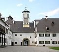
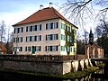
Castles
- Blumenthal Castle (Aichach) (City of Aichach - Blumenthal)
- Friedberg Castle (City of Friedberg)
- Hofhegnenberg Castle (municipality of Steindorf )
- Obergriesbach Castle (municipality of Obergriesbach )
- Pichl Castle ( Aindling Market )
- Scherneck Castle (municipality of Rehling )
- Affing Castle ( Affing municipality )
- Unterwittelsbach Castle - Sisi Castle (City of Aichach - Unterwittelsbach )

Blumenthal Castle

Friedberg Castle
Scherneck Castle

Affing Castle
Unterwittelsbach Castle

Hofhegnenberg Castle


Recreation areas, lakes and bodies of water

- Aindlinger Baggersee
- Auensee (near Kissing)
- Derchinger Baggersee
- Friedberger Baggersee
- Mandichosee (Lech barrage 23 near Merching)
- Mandlachsee (near Pöttmes)
- Radersdorfer Baggersee
- Weitmannsee (near Kissing)
- (The Augsburg autobahn lake , the Kaisersee and the Kuhsee are right on the western border of the district.)
economy
The economy in the rural district is essentially based on a number of innovative medium-sized companies and many craft businesses. The central location in the middle of the economic region Munich-Augsburg-Ingolstadt is a major advantage of the location.
In the Future Atlas 2016 , the district was ranked 135th out of 402 districts, municipal associations and independent cities in Germany, making it one of the regions with “future opportunities”.
In October 2018, the unemployment rate in the Aichach-Friedberg district was 1.8%.
media
The daily newspaper Aichacher Zeitung appears in the district .
traffic
The Munich-Augsburg railway company ran its route through the southern district as early as 1840. In Mering, the Bavarian State Railroad had a railway branched off southwards towards Weilheim in 1898.
The northern part with the district towns of Aichach and Friedberg was opened up in 1875 by the Ingolstadt – Augsburg route. The rail network had now reached its present size. The federal highway 8 and the federal highway 300 are of decisive importance for automobile traffic. For air traffic there is the Augsburg airfield .
Communities
(Residents on December 31, 2019)
Other communities
|
|
Protected areas
There are three nature reserves , seven landscape protection areas , seven FFH areas and at least twelve designated geotopes in the district (as of August 2016).
See also
- List of nature reserves in the Aichach-Friedberg district
- List of landscape protection areas in the Aichach-Friedberg district
- List of FFH areas in the Aichach-Friedberg district
- List of geotopes in the Aichach-Friedberg district
- List of communities in the Aichach-Friedberg district
- List of places in the district of Aichach-Friedberg
License Plate
On July 1, 1975, the district was assigned the AIC , which has been valid since July 1, 1956 for the Aichach district. It is still issued today.
Until the 1990s, vehicles from the old district of Friedberg received license plates with the letters U to Z and the letter pairs from UA to ZZ, each with the numbers from 1 to 999.
Since July 11, 2013, the license plate liberalization has also made the distinguishing mark FDB ( Friedberg ) available.
literature
- Martin Kluger : Wittelsbacher Land. Aims in the Aichach-Friedberg district , context, Augsburg 2013, ISBN 978-3-939645-64-1 .
- District Office Aichach-Friedberg (Hrsg.): The district of Aichach-Friedberg introduces itself. WEKA-Verlag, Mering 2003.
- Erich Hoffmann: Aerial photos from the Wittelsbacher Land , Mayer & Söhne GmbH publishing house, Aichach 2002, ISBN 3-923778-05-8 .
- Landschaftspflegeverband Aichach-Friedberg e. V .: Natural treasures in the Wittelsbacher Land - A journey of discovery to the treasures on our doorstep , Aichach 2014.
Web links
- Entry on the coat of arms of the Aichach-Friedberg district in the database of the House of Bavarian History
- Literature from and about Aichach-Friedberg district in the catalog of the German National Library
- Aichach-Friedberg district: Official statistics of the LfStat
- Natural treasures book (full version)
Individual evidence
- ↑ "Data 2" sheet, Statistical Report A1200C 202041 Population of the municipalities, districts and administrative districts 1st quarter 2020 (population based on the 2011 census) ( help ).
- ^ Wilhelm Volkert (ed.): Handbook of Bavarian offices, communities and courts 1799–1980 . CH Beck, Munich 1983, ISBN 3-406-09669-7 , p. 97 .
- ^ Ordinance on the reorganization of Bavaria into rural districts and independent cities of December 27, 1971
- ↑ StBA: Changes in the municipalities in Germany, see 1994
- ↑ Entry on the coat of arms of the Aichach-Friedberg district in the database of the House of Bavarian History , accessed on September 4, 2017 .
- ↑ The district coat of arms . Aichach-Friedberg district, accessed on September 4, 2017 .
- ↑ Future Atlas 2016. (No longer available online.) Archived from the original on October 2, 2017 ; accessed on March 23, 2018 . Info: The archive link was inserted automatically and has not yet been checked. Please check the original and archive link according to the instructions and then remove this notice.
- ↑ "Data 2" sheet, Statistical Report A1200C 202041 Population of the municipalities, districts and administrative districts 1st quarter 2020 (population based on the 2011 census) ( help ).
Districts:
Aichach-Friedberg |
Altötting |
Amberg-Sulzbach |
Ansbach |
Aschaffenburg |
Augsburg |
Bad Kissingen |
Bad Toelz-Wolfratshausen |
Bamberg |
Bayreuth |
Berchtesgadener Land |
Cham |
Coburg |
Dachau |
Deggendorf |
Dillingen on the Danube |
Dingolfing-Landau |
Danube Ries |
Ebersberg |
Eichstätt |
Erding |
Erlangen-Höchstadt |
Forchheim |
Freising |
Freyung-Grafenau |
Fürstenfeldbruck |
Fürth |
Garmisch-Partenkirchen |
Gunzburg |
Hatred Mountains |
Yard |
Kelheim |
Kitzingen |
Kronach |
Kulmbach |
Landsberg am Lech |
Landshut |
Lichtenfels |
Lindau (Lake Constance) |
Main-Spessart |
Miesbach |
Miltenberg |
Mühldorf am Inn |
Munich |
Neuburg-Schrobenhausen |
Neumarkt in the Upper Palatinate |
Neustadt an der Aisch-Bad Windsheim |
Neustadt an der Waldnaab |
Neu-Ulm |
Nuremberg Country |
Oberallgäu |
Ostallgäu |
Passau |
Pfaffenhofen an der Ilm |
Rain |
Regensburg |
Rhön-Grabfeld |
Rosenheim |
Roth |
Rottal-Inn |
Schwandorf |
Schweinfurt |
Starnberg |
Straubing Arch |
Tirschenreuth |
Traunstein |
Unterallgäu |
Weilheim-Schongau |
Weißenburg-Gunzenhausen |
Wunsiedel in the Fichtel Mountains |
Wurzburg
Independent cities:
Amberg |
Ansbach |
Aschaffenburg |
Augsburg |
Bamberg |
Bayreuth |
Coburg |
Erlangen |
Fürth |
Hof (Saale) |
Ingolstadt |
Kaufbeuren |
Kempten (Allgäu) |
Landshut |
Memmingen |
Munich |
Nuremberg |
Passau |
Regensburg |
Rosenheim |
Schwabach |
Schweinfurt |
Straubing |
Willows in the Upper Palatinate |
Wurzburg