
Rastatt district
| coat of arms | Germany map |
|---|---|

|

Coordinates: 48 ° 52 ' N , 8 ° 13' E |
| Basic data | |
| State : | Baden-Württemberg |
| Administrative region : | Karlsruhe |
| Region : | Middle Upper Rhine |
| Administrative headquarters : | Rastatt |
| Area : | 738.75 km 2 |
| Residents: | 231,018 (Dec. 31, 2018) |
| Population density : | 313 inhabitants per km 2 |
| License plate : | RA, bra |
| Circle key : | 08 2 16 |
| NUTS : | DE124 |
| Circle structure: | 23 municipalities |
| Address of the district administration: |
Am Schlossplatz 5 76437 Rastatt |
| Website : | |
| District Administrator : | Toni Huber ( CDU ) |
| Location of the Rastatt district in Baden-Württemberg | |
  |
|
The district of Rastatt is a district in Baden-Württemberg . It belongs to the Middle Upper Rhine region in the Karlsruhe administrative district . The administrative headquarters are in Rastatt .
geography
location

The district of Rastatt has a share in the Upper Rhine Plain in the west, in the northern Black Forest in the east and in the foothills at its transition. The heavily forested low mountain range of the middle and lower Murg valley forms the eastern part of the district. The highest elevation in the Rastatt district is the Hohe Ochsenkopf , the summit of which rises 1054 m above sea level. The highest point in the northern Black Forest, the Hornisgrinde , is only a few kilometers south of the district boundary. At Au am Rhein , the Rhine leaves the district at an altitude of around 105 m above sea level.
Neighboring areas
The district of Rastatt borders, starting clockwise in the north, on the districts of Germersheim (in Rhineland-Palatinate ), Karlsruhe , Calw , Freudenstadt and the Ortenau district as well as on France with the local arrondissements of Haguenau and Wissembourg within the Département Bas-Rhin , with the Rhine forms the natural border with France and Rhineland-Palatinate in the west. With an area of 140.2 km², the urban district of Baden-Baden forms one large and three small enclaves , all of which lie within the district area. On the other hand, the district has three small exclaves in the urban district of Baden-Baden. The largest of these houses the Waldenecksee , the smallest the former Fremersberg monastery .
Division of space

According to data from the State Statistical Office , as of 2015.
Protected areas
The Black Forest National Park, established in 2014, is one fifth of its area in the highlands of the districts of Forbach and Bühl. The Rastatt district has 29 nature reserves . According to the protected area statistics of the State Institute for the Environment, Measurements and Nature Conservation Baden-Württemberg (LUBW), 4026.61 hectares of the district are under nature protection, that is 5.45 percent. The 26 protected landscape areas in the district have a total area of 22,600 hectares and thus take up over 30 percent of the district area.
history
The district of Rastatt goes back to the old upper office or district office of Rastatt, which initially existed as a city office and first country office, later as city and first country office and second country office, but was merged into the Oberamt Rastatt in 1815. In the course of history, the later district office of Rastatt was changed several times. In 1872, for example, the municipalities of the dissolved Gernsbach district office and in 1924 some municipalities of the dissolved Baden district office were included. In 1939 the Rastatt district office was renamed the Rastatt district. However, since the 19th century, the communities in what is now the district have been part of the district offices of Baden and Gernsbach, as well as the Achern and Bühl district offices . After 1939 there were only the two districts of Rastatt and Bühl in today's district . At the same time, the urban district of Baden-Baden was established.
During the district reform , the (old) district of Rastatt was merged with most of the communities in the Bühl district, three communities in the Kehl district and the former Württemberg community of Loffenau in the Calw district to form the new Rastatt district. The urban district of Baden-Baden was retained after attempts had previously been unsuccessful to integrate it into the district in the 1950s. Baden-Baden is thus the smallest urban district in Baden-Württemberg today.
As early as January 1, 1972, Ebersteinburg was incorporated into the Baden-Baden district. On April 1, 1972, Waldprechtsweier was reclassified to the Karlsruhe district and the portion of Moosbronn that had previously belonged to the municipality of Bernbach in the Calw district was reclassified to the city of Gaggenau and thus to the Rastatt district.
On January 1, 1974, Haueneberstein and on January 1, 1975 Sandweier were incorporated into the city of Baden-Baden. On January 1, 1977, the village of Tauchert was reclassified from Forbach to Baiersbronn ( Freudenstadt district ).
After the municipal reform has been completed, the Rastatt district will still comprise 23 municipalities, including six towns and of these three major district towns (Bühl, Gaggenau and Rastatt). The largest city is Rastatt, the smallest municipality is Weisenbach.
Population development
The population figures are census results (¹) or official updates from the Baden-Württemberg State Statistical Office ( main residences only ).
|
|
politics
The district is administered by the district council and the district administrator.
District council
The district council is elected for five years by those entitled to vote in the district. The local elections on May 26, 2019 led to the result shown in the diagrams.

| Parties and constituencies | % 2019 |
Seats 2019 |
% 2014 |
Seats 2014 |
% 2009 |
Seats 2009 |
% 2004 |
Seats 2004 |
% 1999 |
Seats 1999 |
% 1994 |
Seats 1994 |
% 1989 |
Seats 1989 |
||
|---|---|---|---|---|---|---|---|---|---|---|---|---|---|---|---|---|
| CDU | Christian Democratic Union of Germany | 29.8 | 18th | 37.8 | 24 | 40.1 | 28 | 46.6 | 32 | 48.0 | 32 | 41.5 | 29 | 41.6 | 29 | |
| GREEN | Alliance 90 / The Greens | 16.4 | 10 | 10.5 | 7th | 9.8 | 6th | 7.8 | 5 | 4.7 | 3 | 7.9 | 5 | 7.8 | 5 | |
| SPD | Social Democratic Party of Germany | 16.1 | 10 | 18.9 | 12 | 19.8 | 14th | 20.9 | 14th | 26.3 | 16 | 27.5 | 18th | 25.9 | 16 | |
| AfD | Alternative for Germany | 8.3 | 5 | 4.3 | 3 | - | - | - | - | - | - | - | - | - | - | |
| FDP | Free Democratic Party | 4.6 | 3 | 3.6 | 2 | 7.2 | 4th | 4.9 | 3 | 4.1 | 2 | 4.6 | 2 | 4.2 | 2 | |
| LEFT | The left | 1.0 | 1 | - | - | - | - | - | - | - | - | - | - | - | - | |
| Pirates | Pirate Party Germany | - | - | 0.4 | 0 | - | - | - | - | - | - | - | - | - | - | |
| REP | The Republicans | - | - | - | - | - | - | - | - | 1.3 | 0 | 2.5 | 1 | 3.9 | 2 | |
| FWG | Free community of voters | 22.0 | 13 | 22.5 | 15th | 19.8 | 14th | - | - | - | - | - | - | - | - | |
| Flat share | Electoral associations | - | - | - | - | - | - | 19.3 | 13 | 15.6 | 10 | 16.0 | 11 | 16.6 | 10 | |
| For | For our Rastatt | 1.9 | 1 | 2.0 | 1 | 1.9 | 1 | - | - | - | - | - | - | - | - | |
| Otherwise. | Others | - | - | - | - | - | - | 0.6 | 0 | - | - | - | - | - | - | |
| total | 100 | 61 | 100 | 64 | 100 | 67 | 100 | 67 | 100 | 63 | 100 | 66 | 100 | 64 | ||
| voter turnout | 56.4% | 47.1% | 48.7% | 49.4% | 53.1% | 66.6% | 63.9% | |||||||||
- WG: Voter associations, as the results from 1989 to 2004 cannot be broken down into individual groups of voters.
District Administrator
The district council elects the district administrator for a term of eight years. This is the legal representative and representative of the district as well as chairman of the district council and its committees. He heads the district office and is an official of the district. His area of responsibility includes the preparation of the district council meetings and its committees. He calls meetings, chairs them and implements the resolutions passed there. He has no voting rights in the committees . His deputy is the first state official.
The district administrators of the Bühl district since 1945:
- 1946–1951: Edwin Grüninger
- 1951–1971: Erwin Trippel
- 1971–1972: Josef Großmann
The senior officials or district administrators of the regional office or district office or district of Rastatt since 1803:
- 1803–1815: Josef Bendikt Spinner (1810–1815 at the City and First Land Office)
- 1810–1815: Johann Baptist Schafheitlin (at the Second Landamt)
- 1815–1816: Josef Odenwald
- 1816–1819: Emmerich Wilhelm Kirn
- 1819–1832: Karl Müller
- 1832–1844: Friedrich Theodor Schaaff (1848 member of the preliminary parliament )
- 1844–1850: Gottlieb Friedrich Lang
- 1850: Adolf Schütt
- 1850–1855: Rudolf Graf von Hennin
- 1856–1871: Ludwig Schaible
- 1872–1874: Eduard Engelhorn
- 1874–1886: Karl Richard
- 1886–1889: Max Föhrenbach
- 1889-1891: Otto Beck
- 1891–1899: Albert Muth
- 1899–1908: Oskar Frech
- 1908–1919: Karl Hoerst
- 1919–1924: Julius Guth-Bender
- 1924–1934: Alfred Tritscheler
- 1935–1938: Karl Müller
- 1938-1945: Paul Baer
- 1945–1947: Pius Uhrig
- 1947-1956: Wilderich Cuno
- 1956–1972: Erwin Burkard , CDU
- 1973–1989: Erich Würfel
- 1989–2005: Werner Hudelmaier , CDU
- 2005–2019: Jürgen Bäuerle , CDU
- from May 1, 2019: Toni Huber , CDU
coat of arms

The coat of arms of the district of Rastatt shows in a square shield: 1 in gold a red wine ladder, 2 in blue a golden grape, 3 in blue a blue inseminated, filled golden rose with green sepals, 4 in gold a red sloping bar. The coat of arms was awarded on May 24, 1974 by the Ministry of the Interior of Baden-Württemberg .
On the one hand, the coats of arms symbolize the former rulers in the district, the Counts of Eberstein ("Ebersteinische Rose") and the Margraves of Baden (red sloping bar), and on the other hand, they are economic symbols (grapes and wine ladder) that represent the fruit and viticulture in the district. The wine ladder is also included in the coat of arms of the district town of Rastatt.
The old district of Rastatt had a different coat of arms before 1973. This showed a red sloping bar in gold, accompanied at the top by a red wine ladder and at the bottom by a red heraldic rose with blue clusters and green sepals. This coat of arms, which was awarded by the Ministry of the Interior of Baden-Württemberg on March 23, 1964, already bore the majority of the symbols of today's coat of arms, only the grape was added to the new coat of arms.
See also: List of coats of arms in the Rastatt district
District partnerships
The Rastatt district has had a partnership with the city of Vantaa in Finland since 1968 and with the province of Pesaro and Urbino in Italy since 1996 .
Economy and Infrastructure


Of the 79,653 employees subject to social security contributions in the district, 40,754 were employed in the manufacturing industry in 2007. The largest employer is Daimler AG with large plants in Rastatt and Gaggenau, which together have around 13,000 employees. The Rastatt district is a member of the Karlsruhe Technology Region Association .
In the Future Atlas 2019, the district of Rastatt ranks 134th out of 401 districts, municipal associations and independent cities in Germany (after 106th place in 2016) and is therefore one of the regions with "easy opportunities".
traffic
The federal autobahn 5 Basel - Karlsruhe , several federal highways, including the B 3 Basel – Karlsruhe, the B 36 , the B 500 (starting at the Iffezheim Rhine barrage , from the Bühlerhöhe to the Kurhaus Sand as a Black Forest High Road ) and the B 462 run through the district area ( Black Forest Valley Road ). Numerous state and district roads also open up the district.
An important railway junction is in Rastatt ( Rheinbahn , Rheintalbahn and Murgtalbahn ). There is also the Karlsruhe Stadtbahn . The S 7 and S 71 lines lead from Karlsruhe on various routes via Baden-Baden and Bühl to Achern , and the S 8 and S 81 into the Murgtal. The upgraded and new Karlsruhe – Basel line is on the Rhine plain. At Rastatt, the 4,270-meter-long Rastatt tunnel will in future accommodate through traffic on the route. The start of the construction of the two tubes took place in 2016.
Furthermore, the regional airport Karlsruhe / Baden-Baden ( Baden-Airpark ) is located in the district area (municipality Rheinmünster, district Söllingen), which is the second largest airport in Baden-Württemberg and one of the largest regional airports in Germany with around one million passengers per year.
District facilities
The district of Rastatt is the sponsor of the Wilhelm-Hausenstein-Gymnasium Durmersheim, the following vocational schools : Bühl trade school, Gaggenau trade school - Carl Benz school -, Rastatt trade school - Josef Durler school -, Gernsbach trade school - papermaking school - with a papermaking center, commercial college ( Commercial school) Bühl, commercial college (commercial school) Gernsbach, commercial college (commercial school) Rastatt, Elly-Heuss-Knapp-Schule (home economics-socio-educational school) Bühl and Anne-Frank-Schule (home economics-socio-educational school) Rastatt also the following special needs education - and advice centers : Rheintalschule Bühl, Hildaschule Durmersheim, Erich-Kästner-Schule Gaggenau, Augusta-Sibylla-Schule Rastatt (all support focus on learning), Pestalozzi-School Rastatt (support focus on intellectual development) and Astrid-Lindgren-School Iffezheim with school kindergarten (support focus on language ). In addition, the district of Rastatt maintains a district media center, the Mittelbaden media center, which provides services for the schools in the Baden-Baden district and the Rastatt district on behalf of the law.
Together with the city of Baden-Baden, the district of Rastatt is a partner in the Mittelbaden gGmbH clinic based in Baden-Baden. This runs the Baden-Baden City Clinic as well as the clinics and care facilities in the Rastatt district, namely the Bühl, Forbach and Rastatt district hospitals, the Gernsbach Geriatric Rehabilitation Clinic, the Kuppenheim retirement and nursing home, the Bühl Erich Burger home and the Hub district nursing home and the two care homes Schafberg in Lichtental and Theresienheim Baden-Baden.
PFC scandal
In the mid-2000s, perfluorinated and polyfluorinated chemicals (PFC) were released into the environment in the Rastatt district, mainly on a strip between Rastatt and Bühl . These organic compounds could be detected in several soil samples and in the groundwater. Paper sludge from the local paper industry, which was composted and spread on agricultural fields, is believed to be the origin of the PFCs. Two waterworks belonging to the Rastatt municipal utility had to be temporarily disconnected from the supply network.
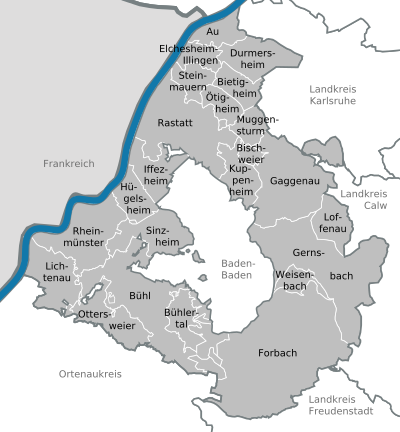
Communities
(Residents on December 31, 2018)

Municipalities before the district reform
Before the district reform on January 1, 1973 and the community reform , the (old) Rastatt district had a total of 45 communities since 1938 , including the four cities of Gaggenau, Gernsbach, Kuppenheim and the district town of Rastatt, which has been a major district town since 1956 .
On March 7, 1968, the state parliament of Baden-Württemberg set the course for a community reform . With the law to strengthen the administrative power of smaller municipalities , it was possible for smaller municipalities to voluntarily unite to form larger municipalities. The community of Rotenfels, which merged with the city of Gaggenau on January 1, 1970, started in the old district of Rastatt . In the period that followed, the number of communities steadily decreased. On January 1, 1972, Ebersteinburg was incorporated into the Baden-Baden district and on April 1, 1972 Waldprechtsweier was incorporated into the Malsch community ( Karlsruhe district ). Both communities thus left the Rastatt district. The remaining communities in the old Rastatt district merged into the new, enlarged Rastatt district on January 1, 1973, but on January 1, 1974 it gave the Haueneberstein community and on January 1, 1975 the Sandweier community, both of which belonged to the old Rastatt district , to the city of Baden-Baden.
The largest municipality in the old Rastatt district was the large district town of Rastatt . The smallest community was Freiolsheim.
The old district of Rastatt last covered an area of 545 km² and had a total of 143,150 inhabitants at the 1970 census .
The table shows the population development of the old Rastatt district up to 1970. All population figures are census results.
|
|
In the table, the municipalities of the old Rastatt district are before the municipal reform. With the exception of Waldprechtsweier, which came to the district of Karlsruhe as a result of the incorporation to Malsch , and the three municipalities incorporated into the urban district of Baden-Baden¹, all communities still belong to the district of Rastatt.

License Plate
On July 1, 1956, the district was assigned the distinguishing sign RA when the vehicle registration number that is still valid today was introduced .
Until the 1990s, vehicles from the old district of Bühl received license plates with the letter pairs LA to ZZ and the numbers from 100 to 999.
As part of the license plate liberalization , the distinguishing mark BH of the former district of Bühl has been available as a desired license plate since December 9, 2013 .
literature
- State archives office Baden-Württemberg, district Rastatt and state media center Baden-Württemberg (ed.): District descriptions of the state of Baden-Württemberg - The district of Rastatt . Jan Thorbecke Verlag, Stuttgart 2002. 2 volumes, 1192 pages, ISBN 3-7995-1364-7
- Art and cultural monuments in the Rastatt district and in Baden-Baden , published by the Rastatt district and the city of Baden-Baden, published by Konrad-Theiss Verlag GmbH, Stuttgart 2002, ISBN 3-8062-1599-5
- Ulrich Coenen: The architecture of the northern Ortenau. Monuments in Bühl, Bühlertal, Ottersweier, Lichtenau, Rheinmünster and Sinzheim , Karlsruhe 1993, ISBN 3-927725-14-5
Web links
- Official website of the district
- District publications
- Literature from and about the Rastatt district in the catalog of the German National Library
Individual evidence
- ↑ State Statistical Office Baden-Württemberg - Population by nationality and gender on December 31, 2018 (CSV file) ( help on this ).
- ↑ Survey of land according to type of actual use in 2015
- ↑ LUBW protected area statistics ( Memento from January 20, 2015 in the Internet Archive ) Status: October 29, 2015
- ↑ a b Federal Statistical Office (ed.): Historical municipality register for the Federal Republic of Germany. Name, border and key number changes in municipalities, counties and administrative districts from May 27, 1970 to December 31, 1982 . W. Kohlhammer, Stuttgart / Mainz 1983, ISBN 3-17-003263-1 , p. 483, 500 f .
- ↑ Result of the district council election 2019
- ^ Result of the district election 2014
- ^ Result of the district election 2009
- ↑ [1] ( Page no longer available , search in web archives ) Info: The link was automatically marked as defective. Please check the link according to the instructions and then remove this notice. Distribution of votes in the district elections 1989–2009
- ↑ [2] ( Page no longer available , search in web archives ) Info: The link was automatically marked as defective. Please check the link according to the instructions and then remove this notice. Distribution of seats in district elections 1989–2009
- ↑ Future Atlas 2016. Archived from the original on October 2, 2017 ; accessed on March 23, 2018 .
- ↑ Prognos Zukunftsatlas 2019. Retrieved on August 5, 2019 .
- ↑ PFC - An overview of the scandal. In: Baden's latest news. Retrieved August 5, 2019 .
- ↑ Patricia Klatt, Andreas Frey: Where did that stuff come from? In: Faz.net. September 4, 2016, accessed August 5, 2019 .
- ↑ State Statistical Office Baden-Württemberg - Population by nationality and gender on December 31, 2018 (CSV file) ( help on this ).
Alb-Danube District | Baden-Baden | Biberach | Lake Constance district | Boeblingen | Breisgau-Upper Black Forest | Calw | Emmendingen | Enzkreis | Esslingen | Freiburg im Breisgau | Freudenstadt | Göppingen | Heidelberg | Heidenheim | Heilbronn (Land) | Heilbronn (city) | Hohenlohekreis | Karlsruhe (State) | Karlsruhe (city) | Constance | Loerrach | Ludwigsburg | Main-Tauber district | Mannheim | Neckar-Odenwald district | Ortenaukreis | Ostalbkreis | Pforzheim | Rastatt | Ravensburg | Rems-Murr-Kreis | Reutlingen | Rhein-Neckar District | Rottweil | Schwäbisch Hall | Schwarzwald-Baar district | Sigmaringen | Stuttgart | Tübingen | Tuttlingen | Ulm | Waldshut | Zollernalb district
.svg)
Basking | Backnang | Baden-Baden | Balingen | Biberach | Boeblingen | Bruchsal | Book | Bühl | Calw | Crailsheim | Donaueschingen | Ehingen | Emmendingen | Esslingen | Freiburg (city) | Freiburg (State) | Freudenstadt | Friedrichshafen | Göppingen | Hechingen | Heidelberg (city) | Heidelberg (Country) | Heidenheim | Heilbronn (city) | Heilbronn (Land) | Black Forest | Horb | Karlsruhe (city) | Karlsruhe (State) | Throat | Constance (city) | Constance (Country) | Künzelsau | Lahr | Leonberg | Loerrach | Ludwigsburg | Mannheim (city) | Mannheim (State) | Mergentheim | Mosbach | Muellheim | Münsingen | Neustadt | Nürtingen | Offenburg | Öhringen | Pforzheim (city) | Pforzheim (Country) | Rastatt | Ravensburg | Reutlingen | Rottweil | Säckingen | Saulgau | Schwäbisch Gmünd | Schwäbisch Hall | Sigmaringen | Sinsheim | Stockach | Stuttgart | Tauberbischofsheim | Tettnang | Tübingen | Tuttlingen | Überlingen | Ulm (city) | Ulm (State) | Vaihingen | Villingen | Villingen-Schwenningen | Waiblingen | Waldshut | Cheeks | Wolfach