
Catfish catch
| coat of arms | Germany map | |
|---|---|---|

|
Coordinates: 49 ° 20 ' N , 6 ° 43' E |
|
| Basic data | ||
| State : | Saarland | |
| County : | Saarlouis | |
| Height : | 182 m above sea level NHN | |
| Area : | 42.17 km 2 | |
| Residents: | 9183 (Dec. 31, 2019) | |
| Population density : | 218 inhabitants per km 2 | |
| Postcodes : | 66794-66798 | |
| Primaries : | 06831, 06837 | |
| License plate : | SLS | |
| Community key : | 10 0 44 121 | |
| LOCODE : | DE WFG | |
| Address of the municipal administration: |
Factory site 66798 Wallerfangen |
|
| Website : | ||
| Mayor : | Horst Trenz ( SPD ) | |
| Location of the municipality of Wallerfangen in the Saarlouis district | ||
  |
||

.jpg)
.JPG)
.jpg)
Wallerfangen ( French: Vaudrevange ) is a municipality in the Saarlouis district around 25 km northwest of Saarbrücken, right on the border with France .
geography
.jpg)
Geographical location
.jpg)
.jpg)
.jpg)
.jpg)
Wallerfangen is located in the central Saar valley opposite the confluence of the Prims in the Saar. The Lumpenbach rises in the Wallerfanger Sonnental, the Wallerfanger Bach in the Wallerfanger Blaulochtal. Both streams unite in the park of the St. Nikolaus Hospital. The Wallerfanger Mühlenbach, which rises in the south of the district, joins the Wallerfanger Bach in Park Villeroy, before the water flows into what is now the Saar Altarm.
The Wallerfangens district is part of the 17 km long and nine km expanded Saarlouis-Dillinger Saar Valley. The Saar takes on the Prims coming from the northeast, whose lower reaches form a valley cross with the Saar. The area of the Prim's estuary forms a scree-rich and moor-like depression on which the villages of Pachten and Dillingen lie. The area is dominated by the dominant Limberg by 180 m. With the sharp step of the Ittersdorfer Gau, the mountain frames the so-called "sand", a clay-covered, sandy, agriculturally used plain. It is cut off in the south by the Bisttal widening and falls with a gorged slope to the low of the Saar. On the opposite side, the cut terrace stairs of the so-called "Gries" rise much flatter. The eastern boundary of these terrace stairs is formed by the Schwarzenholzer Heights, which can be seen as the edge of the Prims-Blies hill country. On the right bank of the Saar, the Prims heaped a huge staircase made of gravel and sand. While the main town Wallerfangen lies on a river terrace to the left of the Saar and thus belongs to the Prims-Blies-Hügelland as part of the Saar-Nahe-Bergland, the other districts are all on the Gau , which is characterized by shell limestone ( Saargau ) or Saar- Nied -Gau, which is to be assigned to the Saarland-Palatinate Gäuhochflächen as part of the Lorraine-Palatinate stepland. In the west, the municipality borders politically on France . The district of Leidingen is politically divided into two parts; The German-French border runs right through the village.
The district Wallerfangens was probably already crossed in the Bronze Age (around 2200 to 800 BC) by an important traffic route that led from the Moselle to the Rhine . The path connected most of the Celtic settlement centers of today's Saarland with their fortifications and their princely graves. Within today's Saarland, it led from Merten via Wallerfangen and Lachten through the Nalbach Valley. From the confluence of the Theel into the Prims , he followed the right bank of the Theel to Theley . Here the path forked to the so-called Hunnenring from Otzenhausen , to Rheinheim , as well as to Freisen and Schwarzerden .
Physical-geographical classification
.jpg)
.jpg)
.jpg)
Wallerfangen in the central Saar Valley is assigned to the Hunsrück foreland and thus to the Saar-Nahe mountainous region and the Lorraine stepland , the easternmost section of the Paris basin . Within the eastern French step landscape, the first step of which is the Eocene limestone step surrounding the center of the Paris basin , step 9 of the Paris basin runs with the Limberg massif, the "shell limestone step west of Saarbrücken and Trier" near Wallerfangen.
Characteristic for the Saar-Nahe-Bergland is a structure of areas at different altitudes, which are cut up by larger valleys with associated side valleys. The areas are partially separated from each other by distinct steps. At the beginning of the Tertiary about 65 million years ago, today's area formed a slightly undulating plain that hardly differed from the Variskan hull of the Rhenish Slate Mountains . At that time the room was only a little above sea level. It was then highlighted today in several phases.
The Prims , which flows into the Saar near Wallerfangen in the Pachten district, is the largest tributary of the Saar from the Devonian Hunsrück region . In its lower reaches, the Prims has created a wide valley from Körprich down in the softer upper Kuseler strata and the coarse-grained Vosges sandstone . It left behind mighty gravel and clay terraces in the extensive confluence of the Saar. The wide valley floors, which extend from an imaginary line between Litermont and Steinberg on both valley flanks to the southwest, are inclined towards both the Prims and the Saar. The valley flanks were only created in the outermost estuary by the erosion of the Saar. The mighty erosion masses of rubble, sand and clay were moved by the Ur-Prims with their parallel brooks (Lochbach, Rodener Bach, Kondeler Bach, Beckinger Bach or their predecessors) to the southwest towards the Saar and thus helped to determine the course of the Saar.
In the Saarlouis valley widening, the Saar valley is filled with large masses of gravel over a length of around 15 km and an average width of 2 km. During foundation measures in connection with bridge construction in the first third of the 20th century in Wallerfangen (1927), Fraulautern (1929), Dillingen (1933), as well as railway construction and river regulations near Dillingen, the solid red sandstone was only reached at a depth of 6 m. These erosion masses cannot be ascribed to the Saar, as it only has a gradient of 0.36 ‰ here. Likewise, the left tributaries of the Saar are not possible causes.
The cause of this strong gravel in the Saar valley by the primordial prims is presumably a stronger uplift of the clod of the east wing on the central Saar towards the end of the Tertiary . The Saar slid to the west on the right, more steeply inclined floe and created steep impact slopes on the left, less inclined Triassic plate , such as B. the Wallerfanger Saarengt. The Ur-Prims must therefore be thought of as a river with a steeper gradient than is the case today. In the Diluvium, the water-rich primordial prims exerted strong pressure on the course of the Saar river from the east and forced it to move partly to the west due to the deposition of erosion material. On the Limberg (358.9 m) and the Hoesberg (325.7 m) left of the Saar, traces of old river beds can still be seen. At that time the Saar flowed in the Altdiluvium south of Itzbach, turned around the Itzbacher Königsberg (344.7) to the north and flowed via Eimersdorf into today's Saar valley . It took the Nied to the west of Büren.
The pebbles of the Prims consist mainly of vein and fissured quartz , quartzites , quartzite slates, pebble slate, Permian pebbles , sandstones, conglomerates from the Rotliegend , porphyries and melaphyres . The characteristic Prims gravel can also be found on the Saar terraces. In diluvial and alluvial times, the huge masses of debris built up the river bed more often and shifted the mouth into the Saar several times.
The Wallerfanger Limberg is a largely forested, optically distinctive mountain formation that is pushed forward from the Saar-Nied-Gau to the east and descends steeply in several broad, sharp-edged mountain spurs around 180 m to the Saarlouis-Dillinger Saar Valley. The Limberg is connected to the Ittersdorfer Gau via a threshold . The almost flat plateau of the mountain consists of marly shell sandstone and rises to 359 m. The Limberg is divided by box valleys cut into the main red sandstone like gorges. The star-shaped furrowed, steep valley ends of the Kastentäler lie in the Voltziensandstein. The 326 m high Hoesberg is almost separated from the Limberg and closes the Siersburger Niedtal from the Saar Valley. From the west, the 345 m high Königsberg juts out like a spur. It is surmounted by the trochitic limestone step of the Ittersdorfer Gau by 30 m. Towards the south, the spurs shorten and connect to the Gau at the same height.
The largest part of the mountain unit consists of closed deciduous, mixed and coniferous forest. Beech and oak predominate . In a subordinate manner, birch , aspens and robinia are added to the southern slopes . Maples , ash trees and linden trees grow on the northern slopes . Spruce , Douglas fir and larch trees settle here on coniferous trees . The humid valley is the basis for fern-rich forests of maples, linden, ash and beech trees. The soil here consists of mesotrophic , humus brown earth on block-rich, moving rubble. This rubble is particularly enriched in the numerous parallel erosion channels. Species -rich pearl grass beech forest is widespread on the poorly developed brown earth above the former farmland of the shell sandstone slab. A small part of the Limberg plate is covered by mediocre arable land with an arable value of 40 to 55 and plantation-like orchards. On the southern mountain spur of the Hansenberg in St. Barbara, strawberry cultures are cultivated on the smallest, fertilized and irrigated plots. Located in the immediate vicinity of the industrial sites of the central Saar Valley, the Limberg forests are used for local recreation and air improvement.
Geological-geomorphological situation
.jpg)
.jpg)
.jpg)
The geological subsoil of the main town Wallerfangen is the Middle Buntsandstein , in which the valleys of the Saar and the Prims (on the opposite side of the Saar from Wallerfangen) are buried. The left valley flank of the Saar near Wallerfangen and Dillingen, the Limberg, is formed by a steep Voltzien sandstone step , while a right valley flank is completely missing. The red sandstone is the oldest rock of the Triassic and the outermost edge of the Paris basin. The petrographic nature of the Wallerfanger Buntsandstein is medium to sandy, which guarantees a free circulation of the groundwater. The red sandstone is therefore an important groundwater carrier, which like a giant sponge has high storage capacities for water. It is reddish in color and free of fossils. This suggests that it was formed under continental conditions as a deposit in shallow river valleys or embankment in shallow inland lakes. The climatic conditions when it was created approx. 220 million years ago are comparable to today's dry, subtropical climate.
The predominantly crumbly, easily erodible red sandstone weathered to form nutrient-poor, light sandy soils that are not very favorable for agricultural use and have remained largely forested in history. In contrast to the forest stands on the alkaline soils of the shell limestone in the Saargau, the soils of the red sandstone are more acidic . A mixed oak forest with beeches is characteristic of the lower forest areas , with the beech gaining the upper hand as the altitude increases. The closedness of the forest was broken up by people where younger, tertiary sediments such as alluvial loam were deposited on the red sandstone . This happened up to the geological present on both sides of the lower valley section of the Prims and in the confluence area of the Prims into the Saar.
Above the middle red sandstone lies the upper red sandstone ( red formation ), which is made up of firmer sandstones that are partly clay or carbonate . In earlier times these were extracted as building material in numerous stone quarries. Above this there are layers of shell limestone : The lowest shell limestone layer is formed by sandy-clayey-calcareous rocks. The middle shell limestone layer contains marl with gypsum and anhydrite . The upper shell limestone layer is made up of massive limestone and platy limestone with layers of marl.
Extensive sedimentary terraces of the Saar and Prims rivers are deposited over these solid underground rocks . The different altitudes of these terraces bear witness to the various stages in the deepening of the two rivers and the deposition of carried gravel . The most recent deposits form the floodplain of the two river valleys.
The Saargau is a shell limestone plateau, which does not represent a layer surface . The plateau in the Saargau reaches a maximum height of 400 to 420 m. The Muschelkalk plateau is presumably a leveling surface from the Oligocene (beginning about 33.9 million years ago; end about 23.03 million years ago) to the Pliocene (beginning about 5.333 million years ago; end about 2.588 million years ago), which was caused by river erosion in an alternating humid tropical climate was created. The inconsistent elevation of the area in the Pliocene and Quaternary (beginning around 2.6 million years ago and lasting until today) led to the area being divided up and individual layers of layers being prepared: quartzite in the east and shell limestone, red sandstone to Keuper in the west. The plateau is gently undulating. The full forms are broad and reach heights of 350 to 370 m. In between there are only gently cut valleys. The forest only appears as an island on the plateau. Typical vegetation is the real semi-arid grass in the apron of the forest and on slopes. The plant communities there have sub-Mediterranean elements. The limestone forms heavy, loamy soils through weathering. They are difficult to work in both dry and wet conditions. The soil is so permeable to precipitation that only a few superficial drainage channels form. Since the land value number reaches values of 60 to 70, humans have already been populating the plateau with a field-grass alternation since the Neolithic and expanding the agricultural area to the detriment of the forest. At the end of postglacial dry periods, the shell limestone area was populated with plants from the Pontic flora and interspersed with forest. In terms of human settlement, the Saargau, together with the Bliesgau, is the oldest inhabited area in the Saarland. Since the Gallo-Roman times it has been developed through the important transport connection from Metz to Trier . During the time of the Franconian conquest , several places were founded here, which the village names point to -ingen and -dorf, funeral rites and the Franconian patronage . The -ingen places, which are presumably named after the name of a group leader or a clan elder, could have been founded earlier than the -dorf places.
While viticulture , especially red wine , was still limited to the valleys around 1820, it spread to the plateau around 1835. As a result of the migration of cheap labor into industry in the Saar Valley, a downward trend began around 1850. Accelerated by the phylloxera crisis around 1880 (in the Saar-Moselle area only increased at the beginning of the 20th century), viticulture in the Saar valley and on the Gau plateaus was given up. Towards the end of the 19th century, the Wingerte in the Wallerfang district of St. Barbara were converted into Bungerten and from 1911 onwards, these were replaced by strawberry cultures . Here the steep cultivation slope facing south receives a lot of sunlight.
climate
Wallerfangen is located in the climatically favored and sparsely forested valley area of the central Saar. The middle Saar valley lies deeper than all neighboring areas and is particularly favored by the wind protection of the surrounding land step in the west. Vegetable growing benefits from the humidity in the valley. Late frosts can pose a threat to vegetation. The growing season is relatively long with 171 to 174 days. The mean beginning of the apple blossom is between April 25th and May 5th. The winter rye can be harvested before St. John's Day on June 24th. Up until the phylloxera crisis of the early 20th century, wine was widely grown on the sun-drenched slopes . The natural vegetation on the slopes would be a colline oak-beech mixed forest. In the river floodplains of the Saar and the Prims, a humid alluvial forest would spread without human intervention. The climate in Wallerfangen is temperate oceanic , but warm. There is significant rainfall throughout the year. Even the driest month still shows high rainfall. The annual average temperature is 9.7 ° C. The precipitation falls on average within a year 724 mm. The lowest precipitation with 48 mm falls in April. In contrast, August is the wettest month of the year with 71 mm of precipitation. There is a difference of 23 mm between the driest month and the wettest month.
In terms of temperature, July is the warmest month with an average temperature of 18.3 ° C. With an average of 0.9 ° C, January is the coldest month of the whole year. With regard to the temperature, the average values fluctuate by 17.4 ° C over the course of the year. The precipitation values come from the Saarlouis station in 2016.
|
Climate table Wallerfangen
Source: Climate: Wallerfangen , climate-data.org, accessed on January 31, 2017
|
|||||||||||||||||||||||||||||||||||||||||||||||||||||||||||||||||||||||||||||||||||||||||||||||||||||||||||||||||||||||||||||||||||||||||||||||||||||||||||||||||||||
Neighboring municipalities
The municipality has the following German neighboring municipalities: clockwise these are the municipality of Rehlingen-Siersburg , the city of Dillingen / Saar , the city of Saarlouis and the municipality of Überherrn . On the French side, there are the municipalities: Villing , Vœlfling-lès-Bouzonville , Heining-lès-Bouzonville and Guerstling .
Community structure
The community is made up of the following individual locations (in alphabetical order): Bedersdorf , Düren , Gisingen , Ihn , Ittersdorf , Kerlingen , Leidingen , Oberlimberg , Rammelfangen , St. Barbara , Wallerfangen.
history
Selection of further articles on the history of Wallerfang:
- Overview of the overall history of Wallerfang:
- Overview of the prehistory and early history of Wallerfang:
- Roman history of the Wallerfangen-Dillingen area:
- Middle Ages and Early Modern Times:
- Industrial history:
- Nazi history:
politics
Municipal council
The council with 27 seats is made after the local elections on May 26, 2019 as follows:
| Party / list | Share of votes | Seats | ||
| SPD : | 38.2% | (- 2.7) | 11 seats | (- 1) |
| CDU : | 32.4% | (- 3.6) | 9 seats | (- 1) |
| Greens : | 10.7% | (+ 5.2) | 3 seats | (+ 2) |
| The left : | 6.3% | (- 1.1) | 1 seat | (- 1) |
| FW Catfish catch : | 12.3% | (+ 5.3) | 3 seats | (+ 1) |
mayor
|
|
town hall


From 1816 to 1851, the municipal administration was housed in a building from 1739 at the confluence of Hospitalstrasse and Villeroystrasse and Wallerfanger Hauptstrasse. The two-storey, three-axle building with a mansard hipped roof was located in the immediate vicinity of the Golden Swan Inn, which was demolished in 2011. After Nicolas Adolphe de Galhau had relocated the administration to a building in Hauptstrasse (today Hauptstrasse 13) in 1851, the previous town hall served as a sales point for the Wallerfanger Konsumverein. The association organized the cheap procurement of food and household necessities and also operated a mill. In 1874 the management of the consumer association was taken over by the Wallerfanger stoneware factory. After the stoneware factory was demolished, the baroque building was also laid down in 1937. In the Middle Ages, the square in front of the building was known as the "Plan" and served as the market square of the small town.
On the initiative of Nicolas Adolphe de Galhau, construction began on a new town hall building on today's Adolphshöhe in 1872. The town hall forms a listed square ensemble with three school buildings and has old trees. The completion of the administration building could be celebrated in 1874. By 1876 three school buildings were built on the sides of the square. The town hall building on Hauptstrasse, which was used from 1851 to 1874, was then run as a hotel-restaurant.
The town hall on Adolphshöhe was originally intended to house the district court of the Saarlouis district, which Adolph de Galhau had tried to move to Wallerfangen. However, that did not happen. But the peace court for Wallerfangen and the surrounding communities found space here . The Peace Court, which was previously located on Sonnenstrasse (today Sonnenstrasse 18), met on Adolphshöhe from 1874 to 1879 before it opened up after an administrative reorganization of the courts in the Saarlouis District Court . The courtroom was then used as a school hall. Since the primary school Wallerfangen was housed in the renovated former town hall building in 2005, the old courtroom has served as a school auditorium. The ceramic pictures that the Lorraine artist Aimé Morot created for the courtroom in 1874 are now in the possession of the Wallerfanger Heimatmuseum. The three ceramic pictures depict animal scenes (wild boars, deer and hinds) in the forest in cobalt blue . The municipal administration was housed in the other rooms of the town hall until 1961. With the construction of the new town hall on the former site of the Wallerfanger stoneware factory, the administration moved there. The late classical building ensemble of four building parts was largely unused for a long time. Since the school building erected in 1958 was no longer sufficient for the pupils of the elementary school and the secondary school, it was decided to move the elementary school to the former town hall. The town hall on Adolphshöhe was extensively restored and modernized so that the Wallerfangen primary school was able to move in at the beginning of the 2005/2006 school year.
In the main building of the building complex there are now eight classrooms, a teacher's room and an auditorium. The care rooms for the voluntary all-day school and a gymnasium are located in the adjoining building. Since 2011 the school has had a bistro in a second adjoining building for afternoon care students. The third outbuilding houses the Wallerfanger Heimatmuseum. The community library was previously housed here. After extensive redesign, the museum reopened on September 18, 2015.
The single-storey former town hall building with side wings is adorned with corner blocks and ceramic friezes. The friezes encircle the building and wrap around the upper sandstone frames of the high rectangular cross -frame windows like stirrups . The portal with the Wallerfanger coat of arms and the Latin inscription "MDCCCLXXIV" (1874) is centrally positioned and is flanked by three windows. The two dwelling houses on the sides open in the basement with three windows, with a central twin window being surrounded by two simple windows, on the upper floor with a large twin window and in the gable with a small twin window hatch. Under the eaves of the central part, six small, rectangular twin knee-high windows are arranged above the six cross-floor windows . A small, pointed roof turret with a clock level rises above the slated roof in the middle above the portal axis. In the time of the Third Reich, a swastika was placed over the eaves of the portal.
At the rear of the building, the mid-sized buildings stand out much more than at the front. In addition, further gable gables slide out of the mid-houses on the outside, with the mid-height buildings on the back protruding further from the line of the side facade.
The architecture of the school buildings is similar to that of the town hall. They each consist of a large school hall and an attached teacher's apartment. The design of the school with three separate school buildings in the style of a pavilion school was a remarkable experiment in its time.
For the current town hall see section: "Art in public space"
coat of arms
- Blazon
- “ In blue a silver mill iron , accompanied at the top by a golden double cross with a shortened upper crossbar, at the bottom by a six-pointed golden star. "
The local colors of Wallerfang are blue and white.
history
The coat of arms symbols are already contained in an imprint from 1614 called the “town seal” and probably refer to the earlier four mills in the village (Mühleisen), the seat of the German bellistum of the Duchy of Lorraine in the village ( Lorraine cross ) and an earlier court seat (star). The blue base color of the coat of arms can also be interpreted as a reference to the Wallerfanger blue that was mined in Wallerfangen .
Due to the destruction of Wallerfangens after the establishment of Saarlouis and the ban on coat of arms during the French administration (1793-1815), the coat of arms is likely to have perished. Since 1954 it has been run again with the permission of the Saarland Minister of the Interior .
Parish partnership
A parish partnership was concluded in 1992 with the commune of Saint-Vallier in the Saône-et-Loire department in France. The partnership community lies in the region of Bourgogne Franche-Comté . Saint-Vallier belongs to the arrondissement of Chalon-sur-Saône . The care of the partnership lies in the care of the Wallerfanger Verein for the promotion of the Wallerfangen-Saint-Vallier partnership. The chairman of the association is the current local mayor. The association strives for the exchange of clubs and groups, sporting encounters, the organization of concerts, language courses, excursions and the mutual visit of school classes.
Culture and sights
Museums and cultural buildings

Historical Museum Wallerfangen
The museum on the Adolphshöhe was founded on March 9, 1983 as a local museum, which had already been planned by Wallerfang local researcher Theodor Liebertz at the end of the 19th century. In 1892 Liebertz had already started buying up products from the Wallerfanger ceramics factory in order to exhibit them in a local museum. At the end of 1955, due to his advanced age, he handed over his entire scientific estate to the Wallerfanger Verkehrsverein. In 1976, on the initiative of Hans Neis, a group of regional historical people came together, which on November 8, 1976 established the "Verein für Heimatforschung Wallerfangen e.V." founded. In a former school building on Adolphshöhe, they finally found a place to stay for the exhibits that had been collected so far. In 2011 the facade of the building was renovated and adapted to the architectural form of the Adolphshöhe plaza ensemble. After a two-year renovation period from 2013 to 2015, the local history museum was reopened as the Wallerfangen Historical Museum. It presents 3000 years of history of the place and the region. Housed in a former school building, the museum is part of the listed “Adolphshöhe” forum ensemble, which was built in the second half of the 19th century. On the first Sunday in July, the association has been organizing the Wallerfang ceramic market every year since 1990 on Adolphshöhe.
Farmhouse Museum "Haus Saargau"
In the district of Gisingen, the Saarlouis district has restored a Lorraine farmhouse typical of the former Lorraine part of the Saarland and set up a farmhouse museum. The oldest part of the house, which was built between 1735 and 1750, shows historical furniture from the 18th century. The furniture comes from the collection of the Lorraine local historian and priest Louis Pinck . A collection of take plates from the 19th century is integrated in the rural museum. They are evidence of iron casting as it was practiced in numerous iron foundries in Saarland and Lorraine.
Behind the farmhouse there is a farm garden laid out according to historical templates with individual trees, hedges and flowering shrubs. Herbal and aromatic plants can be found in the individual beds. Orchards with beehives and a display case adjoin the garden. The garden is part of the international project "Gardens without Borders".
Former synagogue

One of the historically important buildings is the former Wallerfangen synagogue at Gartenstrasse 2, at the corner of Saarstrasse. It is the only synagogue building in Saarland that has survived after the war and has not been profaned, and is now used as the church of the New Apostolic Church. The building is a listed building and is used for cultural events in an adapted setting for concerts, lectures and, in particular, the Saarlouis Christian-Jewish dialogue. The small rectangular building with a gable roof, four arched windows and a round window on the narrow side was built in 1893.
Emilianus tunnel:
The historic tunnel is one of the few remaining evidence of Roman mining north of the Alps. In the Middle Ages, azure mining was carried out in Wallerfangen for the purpose of obtaining the paint "azure blue" ( Wallerfanger blue ), which the Nuremberg painter Albrecht Dürer also worked with.
Festhalle Walderfingia The "Walderfingia" festival hall in Bungertstrasse is available for cultural or political events.
.jpg)
Art in public space
Town Hall Square
After the earthenware factory in the center of Wallerfangen was closed in May 1931, the factory buildings stood empty for a few years because it was not yet clear whether and how the buildings could be used from then on. As there was no alternative use in the period that followed and the maintenance of the area was causing ever greater costs for Villeroy & Boch as the owner, it was finally decided to demolish it. In December 1935, the demolition of the first building on today's Rathausstrasse and Maschinenstrasse began and the deep cellars of the building wings were filled with the demolition material. First, however, the historic Warsberg Castle on the company premises and the other buildings on Hauptstrasse and Hospitalstrasse were to be preserved. Since no other use could be found, the Warsberg Castle was demolished. The Wallerfangen municipality then bought the leveled area. After planning by horticultural inspector Lenzen, a park was created on the former factory site. The result was a simple, undemanding facility with lawns that were cut through by straight paths, loose groups of shrubs and some tree plantings. The raised part of the area facing the Katharinenkirche was leveled and connected to the lower part of the park by stairs.
In the middle of the 1950s, the community leadership thought about building a new school building or a sports facility in a central location. In order to find a solution, the municipality put out an urban planning ideas competition for the redevelopment of the park area in 1959. The program included a building for the local administration and the police with associated service apartments, a cultural center with a hall and a restaurant, a hotel-restaurant and two commercial buildings with associated apartments. The Saarlouis architect Karl Hanus was able to win the competition. In a first construction phase, the town hall, the police building and the associated service housing should be built. The cultural center, the hotel and the two residential and commercial buildings were planned for the second construction phase. However, this second section was no longer implemented.
As a result, the new town hall and a pavilion-like building complex for the post office, police and apartments were built by 1961. The town hall, which is now a listed building, is designed as a strictly axially structured, two-storey structure. On the upper floor, a slightly raised block protrudes like a risk, which accentuates the center of the building. It houses the boardroom and the wedding room. The building entrance is located under its overhang. The middle section, completely glazed on the lower and upper floors, is flanked by wall surfaces that are clad with glazed ceramic tiles. They are reminiscent of the ceramic factory that was once located here. The side views of the building are simply designed with two rows of windows one above the other. The slope support opens up with large-format planters protruding from the wall and an outside staircase.
The new, associated terraced garden with a fountain goes back to the Saarbrücken garden architect Wolfgang Walter from Wiesbaden. A long, narrow concrete water basin is embedded in the floor , which bends at right angles and widens in a square shape both at this angle and at each end. A second concrete basin rises in it, which takes on the shape of the lower basin somewhat narrower and seems to float above it. In the extensions of the upper basin, the water sprays from numerous, fine nozzles, each arranged as a square field. In these areas, the edges of the upper basin are partially lowered and allow the water to flow into the lower basin as a curtain. All pools are painted turquoise blue inside to give the flowing water a fresh and clear effect. Together with the outdoor facilities, the town hall was placed under monument protection in July 2008.
Not far from the fountain by Wolfgang Walter, an abstract, colored sculpture (2.30 × 2.95 × 1.90 m) has stood in the green area of the factory square since 1991. The design and execution come from the ceramist Andreas-Josef Kutsche, who was trained in Meißen and Dresden . Blocks, cubes, quarter, half and full cylinders interlock and interlock, piling up to form a massive, multi-parted shape, the shape of which is based on a clay kiln. The glaze in muted black, brown, green, blue and yellow is created in such a way that the impression is created that the plastic is covered with colored tiles. On the 200th anniversary of the founding of the Wallerfanger Faiencerie, the sculpture was initiated by the community and the Wallerfangen Local History Association to keep the memory of the stoneware factory founded by Nikolaus Villeroy alive, which was in operation from 1791 to 1931. Support was provided by Villeroy & Boch, Mettlach.
Nicholas Hospital
In the foyer of the St. Nikolaus Hospital there is a wall mosaic with the figure of the namesake. The saint is depicted as a bishop with a miter and staff. He wears a blue coat over the alb. Next to him is a tub in which three boys are squatting. According to legend, Nicholas brought three young men to life who had been dismembered by an evil host. The mosaic consists mainly of narrow rectangles in the colors beige, blue and red. Golden mosaic stones in the miter and staff as well as in the border and clasp of the mantle enliven the restrained colors. The inscription to the right of the mural reads: "IN 1883 ADOLPHE VON GALHAU FOUNDED THIS HOUSE IN MEMORY OF HIS MOTHER / SOPHIE VILLEROY AND HER FATHER NICOLAS". The wall mosaic (2.45 × 1.35 m) is based on a design by the sculptor Albert Johannes Zapp, who died in 1963.
Regular events
- Every year on the first Sunday in July, the ceramic flea market of the Verein für Heimatforschung Wallerfangen e. V. collectors and exhibitors from Germany, France and Switzerland together.
- Every year on the 2nd weekend in Advent, the Christmas market takes place on Adolphshöhe at the old town hall (current primary school)
- The Left Party directs its political Ash Wednesday every year. a. in Catfish from.
education

Wallerfangen, school on Limberg
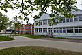
Wallerfangen, school on Limberg
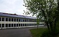
Wallerfangen, school on Limberg

Wallerfangen, elementary school in the former town hall on Adolphshöhe
.jpg)
.jpg)
.jpg)

At the beginning of the 20th century, the Wallerfanger pupils were still being taught in different school buildings: in school buildings on Adolphshöhe, in buildings in the center of the village and in the previous building of the current parish hall at the Katharinenkirche. In 1953, only ten classrooms were available for 13 school classes. So the community decided to build a new sixteen-class school building with a gym on Bungertstrasse. The school, which was inaugurated on April 28, 1958, now housed elementary and secondary schools.
Through numerous school reforms, e.g. For example, the creation of what was then the “extended secondary school” by the Saarland state government, the school experienced an increasing number of pupils. The building from the 1950s could no longer meet the growing requirements, so that the call for a separate school building for the primary school increased. As a result, the late classicist building ensemble from the former town hall with school pavilions on Adolphshöhe from the 1870s was restored, so that the Wallerfangen primary school could move in at the beginning of the 2005/06 school year. The main building now houses eight classrooms, a staff room and an auditorium. The outbuildings house the volunteer all-day school, the gym and a school canteen.
Kindergartens:
There are the following day care centers in the municipality:
- Ittersdorf daycare center
- Kindergarten Gisingen
- Catholic kindergarten St. Katharina, Wallerfangen
Primary schools:
The municipality of Wallerfangen operates two primary schools:
- Wallerfangen primary school
- Gisingen primary school
Secondary school:
There is a community school in Wallerfangen for further educational opportunities:
- Community school "Schule am Limberg", Wallerfangen
High school:
The Wallerfangen community does not have a grammar school itself. The next high schools are in the neighboring towns of Dillingen and Saarlouis
- Albert Schweitzer High School, Dillingen
- Max Planck High School, Saarlouis
- Robert-Schuhmann-Gymnasium, Saarlouis
- Gymnasium am Stadtgarten, Saarlouis
Special school:
- State special school for social development Wallerfangen (founded in 1964, since 2011 the Johann-Hinrich-Wichern-Schule has moved to Saarlouis)
- Anne Frank School, Learning Specialized School, Saarlouis
Community College:
The community offers numerous courses for extracurricular training at an adult education center.
Music school:
The Saarlouis District Music School operates a branch in Wallerfangen.
Conference venues:

Wallerfangen, Sonnental house with the St. Michael chapel
Chapel of the Bildungshaus in the Sonnental

Chapel of the Bildungshaus in Sonnental, figure of Mary

Chapel of the Bildungshaus in Sonnental, tabernacle

Bildungshaus im Sonnental, sgraffito with a depiction of the Archangel Michael fighting the dragon from 1955 by Nikolaus Schmitt-Nennig on the facade
.jpg)
.jpg)
.jpg)
.jpg)
.jpg)
In 1949 representatives of the Catholic Youth Association of the Saarland expressed the wish to build a central educational center on the Saar for the Catholic youth of the Saarland. In 1950 the Diocese of Trier acquired the site of a former farm in the Wallerfanger Sonnental and built a first small youth center with a conference room and a bed for 30 young people. On May 2, 1952, the groundbreaking ceremony for the construction of a new educational center took place, which was completed in 1954. The architect was Toni Laub from Saarwellingen. The first small chapel dedicated to Archangel Michael was set up in 1955 on the ground floor. The Orscholz sculptor N. Herzberger made a Madonna and Child out of linden wood (90 cm). The Saarbrücken master goldsmith Karl Mittermüller created a tabernacle for the house chapel (drifting made of brass with silver plating, 45 × 45 cm). The tabernacle door shows 8 smaller fish in indicated wavy lines. Above it, the letters ΙΧΘΥΣ (ICHTHYS) can be seen in a slight arc . A larger fish stands up and appears to snap at the cross-shaped letter Y with its mouth.
In this context, the artist Nikolaus Schmitt-Nennig, who comes from Nennig , produced a large-format sgraffito on the facade of the house , depicting St. Michael fighting the Satan's dragon. The artist created a similar composition in 1960 for the bell tower hall of the Odile Chapel in Mettlach - Bethingen, which was built between 1955 and 1960 .
On May 1, 1956, the Trier bishop Matthias Wehr inaugurated the new educational center in Wallerfanger Sonnental in the presence of the Saarland Prime Minister Hubert Ney and the Federal President of the BDKJ Willy Bokler . On September 12, 1965, Auxiliary Bishop Carl Schmidt consecrated the youth church of St. Michael. Due to the great popularity of conference groups, a third floor had to be added to the house in 1966/1967. A second large conference room was set up on the new floor in 1975. The first extension to the old building took place in 1972. In 1973 a guest house in the park was completed. In 1983 an extension with various conference rooms was added to the facade of the building. In connection with this redesign, new parking spaces were created in 1984/1985 and the outdoor facilities were redesigned. The Sonnental house has been owned by the supporting company of the Diocese of Trier (TBTmbH) since April 1st, 1998.
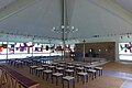
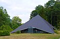
As a leisure and conference center, Haus Sonnental in Wallerfangen currently offers 48 rooms with 110 beds, several conference rooms, a church and sports and leisure opportunities. The St. Michael youth church, located within the extensive facility of the Bildungshaus in Wallerfanger Sonnental, which was built according to plans by the Wadgasser architect Karl Rösinger in 1965, is designed as a slated pyramid roof on a square floor plan. A copper cross rises at the top of the pyramid. While the corners of the slate pyramid stretch down to the floor, the four sides spread out to let light into the interior of a glass room, the walls of which the Saarbrücken artist Gero Koellmann designed in colorful antique and opal glass. Rectangles and pointed triangles form abstract patterns that are framed by colorless glass surfaces. Sculptor Günther Oellers from Linz am Rhein made the altar of the sacred building out of basalt : a halved egg shape seems to be balanced as a cafeteria over a lying, egg-shaped stone as an altar strip . The tent-like, wooden ceiling of the interior is painted white and has few brightly colored accents. A large chandelier with white ball lamps hangs down from the central intersection of the roof trusses. In front of a rustic brick wall that hides the access to the sacristy, the sediles made of black basalt are arranged centrally. The back of the priest's seat is parabolic. To the left of it is a gold-colored, rectangular tabernacle, the doors of which are decorated with flame-like ornaments and whose dark frame is set with 20 rock crystals. To the right of the sediles, a fragment of a late medieval figure of Mary appears to be floating in front of the wall. Other items of equipment include a stand cross made of stainless steel and wood, which is set with four rock crystals, and large candlesticks made of wrought iron. The simple ambo is decorated with colorful enamel surfaces on the shaft. The visitors take a seat on backless stools. The architecture of the sacred building in the Sonnental bears a certain resemblance to the Protestant church in Mettlach-Keuchingen, which was built in the years 1961-1962 by the Saarbrücken architects Günther Mönke and Hubert Wandel, although it was designed in the shape of a tetrahedron .

Wallerfangen, Sonnental

Wallerfangen, Sonnental

Wallerfangen, Sonnental

Wallerfangen, former forester's house in the sun valley


.jpg)
In the immediate vicinity of what is now the Sonnental Educational Center, there was an estate that Isidor-Charles Pillar de Requin had built in 1869 until it was demolished in the early 1960s. The foundation walls of the property survived the demolition. In a small side valley of the Sun Valley, in the so-called Mookenloch, is the former forester's house of the Wallerfangen community in the form of a south-west German cross-house .
Library:
The Catholic parish of St. Katharina operates a public library in the Wallerfang parish and youth home.
religion
Archaeological finds show that as early as the 3rd or 4th century AD, people of Christian faith lived in the immediate vicinity. For historical reasons, Catholicism is predominant in Wallerfangen. For the history of the churches and monasteries in Wallerfangen see:
Churches

Wallerfangen, St. Katharina and St. Barbara
Wallerfangen, St. Michael, built in 1965 by Karl Rösinger

Wallerfangen, St. Nikolaus Hospital Church
Him, St. Hubertus

Gisingen, St. Andreas
Ittersdorf, St. Martin of Tours

Leidingen, St. Remigius

St. Barbara, St. Salvator

Kerlingen, St. Jakobus the Elder and St. Wendelin

Bedersdorf, St. Margaretha
Düren, Our Lady of Lourdes

Hof Limberg, pilgrimage chapel Christ Crucified

.JPG)


.JPG)

.JPG)
.JPG)
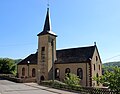
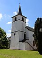
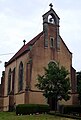
Catholic churches exist in the following districts:
- St. Katharina , Wallerfangen, 1862
- St. Michael, Wallerfangen, 1965
- Wallerfangen, St. Nikolaus Hospital Church, 1883–85
- St. Hubertus , Him, oldest parts from the 12th century / around 1500/1616/1726/1836/1846
- St. Andreas, Gisingen, 1959-60
- St. Martinus , Ittersdorf, 1703/1828 / 1927–28
- St. Remigius , Leidingen, 1530/1742
- St. Salvator, Sankt Barbara, 1949–54
- St. Jakobus the Elder and St. Wendelin, Kerlingen, 1928–30
- St. Margaretha , Bedersdorf, 1732
- Our Lady of Lourdes, Düren, 1884–86
- Maria Queen, Rammelfangen, 1960
- Chapel of the Dear Lady, Oberlimberg, 1960
- Pilgrimage chapel Christ Crucified, Hof Limberg, 1827
Other Christian denominations:
- New Apostolic Church Wallerfangen in the building of the former synagogue
synagogue
The emergence of a Jewish community goes back to the 17th century. In 1685 a Jewish family from Wallerfangen is mentioned who settled in the newly founded fortress town of Saarlouis. As early as 1783 there were twelve Jewish families in Wallerfangen and the neighboring Beaumarais. The Jews living in Beaumarais visited a small prayer room in Wallerfangen. In 1817 a synagogue is mentioned for the first time, which at that time had already been there for a long time and was also visited by the Jewish people living in Beaumarais, Felsberg and Niederlimberg. In the following decades, Wallerfangen remained the capital of the communities in the immediate vicinity. In 1838 a new synagogue was built here in the garden of Herz Kahn. The Jewish families lived mainly from the cattle trade and the butcher shop. The community remained small in the 19th century. The highest number was reached in 1895 with 39 people. The Jewish inhabitants living in Beaumarais, Felsberg and Niederlimberg belonged to the Wallerfanger community. The dead of the Jewish community were buried in Dillingen, and after 1905 also in Saarlouis.
After 1890 the old synagogue stood in the way of an expansion of the Wallerfanger operation of the Villeroy & Boch company. The company took over the costs for a new synagogue, which was built in 1892 in today's Gartenstrasse and on the Sabbath , the 24./25. February 1893 was inaugurated as part of a ceremony for the whole place. Chief Rabbi Dr. Bass friend from Trier gave the inauguration sermon, the synagogue choir from Merzig and a regimental band from Saarlouis provided the musical accompaniment. The symbolic opening of the new sacred building was carried out by the mayor of Wallerfang, René von Boch-Galhau , after the key had been presented to him in a solemn manner. On the occasion of the celebration, numerous catfish catchers had decorated their houses with flags, a pageant with gunshots passed through the town and fireworks were set off. Several Christian associations held a torchlight procession to celebrate the occasion. The synagogue is a simple, approx. 10 m long and 7 m wide hall building with a low gable roof. The Torah shrine was located in a small niche on the east side. On the long side are two window axes with arched windows. The original entrance was on the front side under a round window. It has since been relocated by the later owner, the Neuapolstolissche Gemeinde, the oculus window has been preserved. The plastered building is decorated with corner blocks.
The community maintained a synagogue, a religious school and a mikveh in Kirchhofstrasse. A religion teacher also acted as a prayer leader and animal slaughterer . At the beginning of the 20th century, the position was no longer filled, as church services were rarely held due to the declining number of parishioners. Due to the declining number of Jewish community members, the obligatory number of ten Jewish men in worship was no longer achievable by 1913. When in the 1920s only eleven people belonged to the Wallerfanger community, they visited the synagogue in Beaumarais.
In the 1930s there were only a few Jews left in Wallerfangen: Moses Kahn with his wife Rosa and their adopted daughter Anneliese in Sonnenstrasse, Gertrud Hanau and her sister Rosalie Feiner (née Hanau) with daughter Clementine, who had a white man in Villeroystrasse and haberdashery, Selma Schömann, who ran a haberdashery, white and wool store on Hauptstrasse, Raphael Kahn and Josef Deutsch, who worked as a butcher and lived on the corner of Hauptstrasse and Schlachthausstrasse.
The Wallerfangen synagogue was given up before 1935 and was initially used as a warehouse.
Of the Jewish people born in Wallerfangen or those who lived there for a long time, the following died during the Nazi era: Clementine Feiner (* 1902, deported to the Warsaw Ghetto , lost there), Gertrud Hanau (* 1863, died in the Theresienstadt Ghetto ), Ruth Hirsch (* 1928, deported to Auschwitz ), Rosa Kahn (* 1892, murdered in Auschwitz), Anneliese Kahn (* 1922, murdered in Auschwitz), Moses Kahn (* 1877, on the run in France from his relatives Rosa and Anneliese Kahn separated), Simon Kahn (* 1871, perished in Ghetto Theresienstadt), Selma Schömann (* 1881, deported to Ghetto Piaski , murdered in Trawniki ), Simon Stiefelzieher (* 1896, deported to Majdanek concentration camp , lost there)
After the end of the Nazi persecution of Jews in 1945, the family of Leo Michel (1893–1967) from Niedaltdorf settled in Wallerfangen, which had survived the Nazi era in France. The family lived on Entengasse.
The former synagogue building was confiscated in 1945 and initially returned to the Saar synagogue community . In 1950, the synagogue building was leased by the New Apostolic Church and acquired six years later in 1956. Since then, the former synagogue has been the center of the New Apostolic parish of Wallerfangen. The building has been a listed building since 1990. The building has been renovated several times, most recently in 2004. On February 25, 2015, a memorial plaque was placed on the building in memory of the last Jewish community members.
Cemeteries in Wallerfangen
Medieval churchyard
.jpg)
.JPG)
.JPG)
When in 1987 the house at Hauptstraße 28 (located next to the Gasthaus zum Goldenen Schwan, which was also demolished in 2011) was demolished and its courtyard was expanded to create a parking lot, large numbers of human bones came to light when the sloping terrain was cut. After the original Wallerfanger parish church had been razed with the other buildings of the fortress Walderfingen from 1687, the cemetery was abandoned. In the baroque period, the "Gasthof zum golden Schwanen" was built over the grave places.
The two-storey, seven-axle building had a slate-hipped roof. Since the inn was very popular, the building had become too small for the numerous guests at the end of the 19th century. In 1897 it was replaced by a much larger, three-storey inn in the neo-renaissance style, although the baroque vaulted cellars were retained. The facade was laid out with six axes both in the main street and in the wing of Villeroystraße. The main floor was designed with regard to the ceiling height and the façade richest. The corner of the building was accentuated with a wrought-iron balcony and a small dwelling with flanking volutes and a gable roof with a central obelisk . The historic building had a ballroom with a stage, where family celebrations, dignitaries' meetings, carnival events and the town's annual fair celebrations were held. On July 20, 2011, the demolition of the previously listed building began in order to build a new savings bank here and to widen the main street slightly. The Wallerfangen Local Research Association was able to recover the house number of the building and the year "1897" from the rubble.
Immediately after the traditional inn was demolished in favor of a purist new building by the Kreissparkasse Saarlouis , archaeological excavations by the State Monuments Office of Saarland suspected both the remains of the foundations of the south-eastern section of the medieval Wallerfang parish church of St. Peter and Paul and well over fifty burial places in the former churchyard Period of 1000 years as well as numerous other objects discovered. The inner area of the former Wallerfanger church building was not subjected to a city archaeological investigation. A burial place from 1629 had already been discovered in the area in 1937.
The area of the former churchyard was only systematically examined in a small area in 2011. The burial places showed numerous overlays, so that one can assume that older burials were disrupted when new graves were excavated. The arms of the dead were often bent in a prayer position. Numerous burial objects contained grave goods such as skulls (grave goods for children and unmarried women who died young), remains of the dead costume, jewelry, rosaries and medals . A clasp could be assigned to the Carolingian period . Ceramic shards date from the late Bronze Age through the Roman Empire and the Middle Ages to modern times. A model of a stove tile with a battle scene dates from the Renaissance . Of the 100 or so coin finds from the Roman period to the first half of the 17th century, a particularly well-preserved silver coin from the Archbishop of Trier, Baldwin of Luxembourg, from the first half of the 14th century stands out. Also found was a head part of a Late Bronze Age garment needle and part of a clay vessel, both from around 1000 BC. Chr.
In the course of the resettlement of Wallerfangen from 1705, the place belonged to the parish of St. Peter and Paul of the village Beaumarais, which was established with the fortress town of Saarlouis . The deceased in Wallerfangen, Niederlimberg and St. Barbara had to be buried since the Wallerfang cemetery in Beaumarais was closed. Since the transport of the dead to Beaumarais was difficult, the Wallerfangers laid a new cemetery around 1786 in front of the western entrance of the Augustinian monastery church, which was spared from the razing in 1687 and is now the parish church of St. Catherine.
Plague cemetery

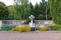
Catfish catch, plague cemetery

Catfish catch, plague cemetery, wayside shrine in the foreground, war memorials in the background

Wallerfangen, plague cemetery, remains of the Wallerfang war memorial in memory of those who died in the First World War

Wallerfangen, memorial to the fallen from 1956


.jpg)
For the epidemic deaths of the 17th century, a provisional cemetery was created outside the city walls from 1635. It was on the corner lot between Hauptstrasse and Estherstrasse. A plague cross still reminds of the catfish caught by the epidemics and buried here. Today's cross was erected by Nicolas Adolphe de Galhau. He had the originally narrow high cross supplemented with a niche and a base. He placed a Pietà in the niche . When the war memorial was erected in 1932, the cross was included in the complex. At that time, the years 1635-1638 were also chiseled into. After the Pietá picture was destroyed by vandalism in the post-war period, a Schöntatt picture ( Mater Ter Admirabilis ) was placed in the niche. Currently, a Pietà can be seen again in the barred niche.
In 1956, near the war memorial for the dead soldiers of the First World War , the Wallerfangen Cenotaph was erected in 1956 with financial support from the Saarland government under Prime Minister Hubert Ney . Seven steps lead to a platform on which the monument stands. A high pillar made of red granite (central stele: 5.20 × 1.10 × 0.50 m) names the years and the inscription "THE FALLEN / FOR EHR / THE LIVING / FOR WARNING" on its front on a protruding and raised projection . A bronze palm frond and an " iron cross " are applied as a sign of honor . Two smaller steles (each side: 1.00 × 0.32 × 0.32 m) with engraved Latin crosses flank the tall stele next to the stepped plinth. The execution was carried out by a stonemason from Fürstenhausen . The author of the monument is unknown.
Capuchin monastery cemetery
.JPG)
Another historical burial site was discovered during the construction of the Villeroysche Rentamt on the corner plot between Hauptstrasse and Sonnenstrasse (Zillkens Eck). On the ascent to Limberg, near the Saarengt at today's Villeroy Castle, several older farmhouses had to be demolished around 1900. Large numbers of human bones were found during the excavation. Presumably it was the cemetery of the Capuchin monastery, which stood on the site of today's Villeroy Castle from 1628 to 1692. During excavation work in 2008 on a new building behind the Villeroy Rent Office, construction workers again came across human remains. Archaeologists excavated numerous skeletons as part of a safety excavation. The finds could not be dated.
The way of the cross to the Limberg plateau begins at the area of the former rent office.
Niederlimberg municipal cemetery
BlickzurKirchevomFriedhofL1040302.JPG)
Today's Wallerfangens cemetery was established in 1853 between the Lumpenbach and Kirchhofstrasse at the foot of the Limberg in the district of Niederlimberg, which has now grown together with Wallerfangen. Since the terrain towards the Lumpenbach is sloping, the difference in height had to be absorbed in terraces. After two expansions in the direction of the Sun Valley in 1958 (approx. 47 × 53 m) and 1986, the cemetery now consists of three parts and has an overall plan of an elongated rectangle. The small former cemetery chapel from the 1920s is located on the southern edge of the oldest part of the burial complex. It has been used as an economic area since 1961.
A new morgue was built with the cemetery expansion in 1958 and expanded in 1996, with a basement and a new concrete pile foundation.
In 2013, the Wallerfangen community erected a new memorial for the Wallerfang soldiers and civilians killed in the world wars of the 20th century on the site of a weathered former "hero memorial" with 27 graves. The cost was € 31,000.
The modern memorial was created by the Saarlouis sculptor workshop Uwe Hassdenteufel & Willi Kasakow. The inscription on the stone reads: "In memory of our sons who died in the war of 1914-1918." Below are the names of 18 catfish catchers who fell as soldiers in the First World War. The list begins with Willi Witzmann (died November 26, 1914) and ends with Gustav Östreicher (died December 10, 1918). The historicizing hero memorial stele (light sandstone from Luxembourg; weight: 2.6 tons) seems to be demolished by a saw or sword blade made of rust-red oxidized Corten steel . The sculptors have positioned pieces of the "Heroes Memorial" on the floor of the green area. Each of the debris bears the names of Wallerfanger soldiers from the Second World War. To express the individuality of each person killed, the sculptors carved each of the nine names in a different script. The area of the facility, delimited with a steel frame, is 8.2 by 4.9 meters in size and is planted. Wallerfang pastor Herbert Gräff blessed the new memorial for the Wallerfang victims of the two world wars in a celebration in April 2014. The modern memorial is intended to question the pathos of the war memorials of the 1920s and encourage reflection on death, destruction and misery.

War victims memorial in the community cemetery

War victims memorial in the community cemetery, sculptors Uwe Hassdenteufel & Willi Kasakow, 2013

Memorial to war victims at the Wallerfanger community cemetery

Community cemetery chapel

Interior of the morgue in the community cemetery
Grave site of the Wallerfanger Borromäerinnen in the community cemetery
.jpg)


.jpg)
.jpg)
.jpg)
Religious customs
Limberg procession
.JPG)
.JPG)
.jpg)
.jpg)

.jpg)
.jpg)
.jpg)
The Limberg procession of the newly married couples from the parishes of St. Ludwig and St. Peter and Paul in Beaumarais , documented for the first time in 1687, took place every year on the first Sunday of Lent. The procession was led by the Saarlouis Maire, the aldermen, and the former Maires. The newlyweds and a large crowd of spectators followed. The young couples, who were obliged to take part in the procession under threat of a fine of two francs, carried bundles of straw, which they set up in the shape of the Lorraine cross at the summit of the 343 m high Limberg . The couple who were the last to marry were allowed to light the straw cross in the evening. The first stop of the pilgrimage was the place of the former Wallerfanger Capuchin monastery in Wallerfanger Engt, today the location of the Villeroy Castle. Then the procession continued up the mountain. The newlyweds paid a monetary fee to the city administration of Saarlouis, a jug of wine, white bread and a herring to the forester on the Siersburg and paid a small tax to the Duke of Lorraine. The pilgrimage of the newlyweds was abolished in this form in 1741. The custom may have been an older Wallerfang folk custom, which was then transferred to Saarlouis.
The Saarlouis fortress governor Thomas de Choisy had a chapel built on the Limberg for construction workers and soldiers of the fortress town to be built in 1680, in which holy masses were held by a Carmelite priest, but a small church cared for by monks had stood here since the Middle Ages . The Limberg was used by Choisy as a quarry for the Saarlouis fortress. The construction workers were housed in barracks on the mountain. On August 31, 1682, the archbishop's authority in Trier gave permission for the benediction of a new chapel on the Limberg, which was looked after by Franciscan hermits. With the end of the fortification work, the construction workers' settlement on the Limberg, including the makeshift chapel, was demolished. However, on the initiative of a hermit and various Saarlouis citizens, a stone chapel was built on the Limberg, which was looked after by the parish of Itzbach (renamed Siersburg in 1937 ) and Rehlingen .
In the years 1722 to 1727, the Metz stone sculptor Pierrar de Corail and his journeymen made a Calvary system with initially seven, then eight footfall stations on behalf of the hermit Claude Virion , which began at the foot of the Limberg with a mount of olives scene and at the summit of the Berges ended with a Holy Sepulcher Chapel . The stone groups of figures were almost life-size.
The hermitage on the Limberg joined the rule and way of life of the German congregation of the Hermit Brothers of St. John the Baptist. Every three years the Trier archbishop's authority carried out a visit to the Limberg Hermitage . The Holy Sepulcher Chapel was expanded to include a Chapel of Our Lady with a garden between 1738 and 1741. The sacred building had three altars (Mother of God high altar, side altars for St. Joseph and St. Anthony), confessionals, a bell, sufficient vasa sacra and paraments. The Holy Sepulcher was located in a crypt under the high altar of the chapel. However, the chapel, which increasingly developed into a pilgrimage chapel, never seems to have been consecrated. The chapel's patronage festival was April 16. In addition, some distance from the chapel was a station dedicated to St. Mary Magdalene . An allegedly miraculous spring was contained in this station, which girls and widows sought to solicit a husband. Small wooden crosses were left at the source as offerings. Since the path from Itzbach to Oberlimberg had turned out to be too long for the priest in charge, the Augustinian canons of Wallerfang increasingly carried out the services of worship.
According to the visitation protocol of 1741, the patron saint of the chapel was the Duke of Lorraine and former King of Poland, Stanislaus I. Leszczyński , who on June 30, 1751 summoned the barefoot Carmelites of the Lorraine Order Province to pastoral care on the Limberg. With the approval of the episcopal authority in Trier, a small hospice was established in the Hermitage on August 29, 1759, which was looked after by two priests and a lay brother. The Archbishop of Trier, Franz Georg von Schönborn , gave the complex the title "Maria vom Berge Karmel". The patronage day of this chapel was July 16, the feast of Our Lady on Mount Carmel , the so-called scapular feast .
The monastery on the Limberg was attached to the north side of the church. It had a basement and rose over two floors. Remains of the chapel have been preserved to this day in the barn of the former manor near the chapel from 1827. When the barn roof was re-roofed in the 1970s, the crypt under the barn was largely filled in with brick rubble by the construction workers, so that today it can only be accessed when bent over.
For the year 1783 the Itzbacher pastor Motte reports that there was more debauchery in the pilgrimages on St. Joseph's Day (March 19), the Annunciation (March 25) and the Birth of the Virgin (September 8) following the pilgrimages Corruption of the youth of both sexes and to the trouble of the good "had come. In 1784 the Carmelites gave up the settlement on the Limberg due to a lack of suitable offspring and the complex went into effect on December 18, 1788 by royal decree of Louis XVI. into the care of the Franciscan monastery in Sierck , which was founded in 1627 and belonged to the Cologne Order Province. But the Sierck monks had been pastoral care of the Limberg chapel since 1785.
In the course of the French Revolution, the facility on the Limberg with an area of about 10 acres was expropriated and leased in 1791 and the monks were driven out, with the leaseholder Poligny from Niederlimberg leaving the chapel open to pilgrims. On the other hand, the revolutionary district administration intervened and sold the area on March 16, 1792 for 3500 livres to the brothers Antonius and Matthias Capitaine from Felsberg , who let the buildings deteriorate and resold the land. During the anti-church struggle of the French Revolution , the eight sculpture groups of Pierrar de Corail and his students were smashed by revolutionary activists. The ruins are still on the Limberg after being secured in 1930. Sculptures of the sleeping disciples are kept in the Villeroyschen Gutshof on the Limberg, the other disciples and a Pietà in the barn on the Limberg plateau. The inscription "Corail fecit 1722" can still be seen on the torso of Our Lady. The destroyed group of the sleeping disciples of Jesus was made by Corail's pupils in the years 1726/1727. The name given to the Wallerfangers "Beim Kloster" and "Kapellenberg" reminds of the religious history of the place.
The Order Province did not give up the claim to the complex during the revolution and continued to appoint superiors: until 1794 this was Father Ananias Helbron from Hilringen and in 1797 Father Chrysostomus Jansen from Oberleuken was appointed. In 1802 the order province itself was dissolved.
It was not until 1827 that Louis Villeroy had the chapel that still exists today built for his estate on the Limberg. In 1840, the Louis Villeroy family also built a new Way of the Cross. Between the ninth and tenth stations of the cross there is a neo-Gothic crucifixion group. In the war winter of 1944/1945, the group of sculptures was badly damaged in the heavy fighting between the German Wehrmacht and the US Army. A white marble plaque is attached to the base of the crucifix in a neo-Gothic frame. Its French inscription, which is based on Mt 11.28 EU , reads: "Venez à moi vous qui êtes affligés MDCCCXXXX" (German translation: Come to me who are saddened, 1840.) The crucifixion scene thematizes a passage from the Passion story according to the Gospel of John ( Joh 19,25-27 EU ):
“At the cross of Jesus stood his mother and his mother's sister, Mary, wife of Clopas, and Mary of Magdala. When Jesus saw his mother and with her the disciple whom he loved, he said to his mother, "Woman, see, your son!" Then he said to the disciple: See your mother! And from that hour on the disciple took her to him. "
While the mother of Jesus gazes at the floor with interlocking fingers at waist height, sunk in pain, the crucified Jesus turns to her. The young disciple standing next to the cross, who in the Christian tradition is identified with the favorite disciple John , looks up to Jesus with a sad look and has his hands folded in front of his chest.
Another stone cross, the so-called "Great Lord God", stands on the Limberg plateau on the forest path from Oberlimberg to the Limberg chapel. The wayside cross, built in the style of the late Baroque in 1810, was traditionally erected by a forest official. He is said to have laid a wolf fishing iron in the forest on the Limberg , which unfortunately became fatal for a family member here. The base of the wayside cross shows a relief of the Holy Family during the so-called Holy Walk . The depiction of the Holy Family could refer to the forest official's ruined family happiness. Above the base canteen holds a cherub a volutenflankierte band with the inscription "O crux ave spes unica" (German translation:. Hail, oh Cross, you only hope). The "Großer Herrgott" wayside cross was restored in 1979.
To this day, many people traditionally move to the Limberg on Good Friday . The almost two kilometer long Herrgottsweg up to the chapel is lined with stations of the cross. The believers make small crosses out of twigs and place them at the foot of the stations after they have performed silent prayers. The pilgrims then fortify themselves at the top of the mountain with quark bread ("Kässchmieren") or potato pancakes ("Grumbeerkeïchelcha"). In consideration of the day of Jesus Christ's death, no music may be played when eating Good Friday food.
- Remnants of the footfalls of Pierrar de Corail, desecrated by revolutionary activists

Catfish catch, remains of the footfalls desecrated by revolutionary activists by Pierrar de Corail, representation of a Pietà

Catfish catch, remains of the footfalls of Pierrar de Corail, kneeling disciple, desecrated by revolutionary activists

Catfish catch, remains of the footfalls of Pierrar de Corail, desecrated by revolutionary activists, seated disciple

Wallerfangen, barn in the former monastery area on the Limberg, where the violated footfalls of Pierrar de Corail are partially kept
.jpg)
.jpg)
.jpg)
.jpg)
Infrastructure and economy
traffic
Antiquity
In antiquity , the Gallo-Roman settlement Contiomagus , today leasing on the opposite side of the Saar from Wallerfangen, formed the intersection of the highways Metz - Mainz and Trier - Strasbourg . Immediately downstream of the Contiomagus fort there was a saar ford until the beginning of the 20th century. At this point, the US troops made the crossing over the Saar during the war winter of 1944/45. The US 90th Infantry Division was able to cross the flooding Saar between the Wallerfanger Bridge and Rehlingen in four places with assault boats and form a bridgehead on St. Nicholas Night (December 5th / 6th) 1944 . In the course of the day, the Americans also managed to create a temporary footbridge over the Saar.
The route of the Roman road from Metz to Mainz ran through the Niedtal and crossed the Saar at Contiomagus, in order to continue along the banks of the Prims and Theel via Lebach and Tholey to the Rhine . In 244 AD, the Saar crossing was improved by building a wooden bridge at Contiomagus. The road from Trier to Strasbourg split at Zerf . The southern route met the Saar Valley near Beckingen and went via Contiomagus and Saarbrücken to Strasbourg, while the northern route ran via Tholey and Schwarzenacker , and then reunited with the Saar Valley route. Both routes were connected to one another via the cross-connections Contiomagus-Tholey and Saarbrücken-Schwarzenacker.
Middle Ages and early modern times
In the Middle Ages, probably around 1100, the Siersburg was built to control the intersection of the trunk roads . In the early modern period, a long-distance trade route from Italy to Flanders led along the Limberg. The route led from Milan via Strasbourg to Saarbrücken , left the Saar valley at the foot of the Siersburg, crossed the Niedbrücke near Siersdorf, ran via Sierck on the Moselle to Luxembourg and from there via Brussels to the Lower Scheldt .
On the right side of the Saar, the medieval road ran through Dillingen, which connected Saarbrücken to Trier via Fraulautern .
In addition, a road led from the valley of the Lorraine Seille via Wallerfangen to Dillingen. Wood from the Upper and Middle Saar, salt from Château-Salins and Dieuze and coal from the Saarbrücken area were transported on this road .
Road traffic
Wallerfangen is connected to the national and international trunk road network via several motorway junctions. This is done via the A 8 and the A 620 . There is a direct connection to France from Ittersdorf via the B 405.
railroad
The nearest train stations are:
- The Dillingen (Saar) train station opened in 1858 . It is a railway junction on the Saar line of the Deutsche Bahn (Saarbrücken-Trier-Koblenz) with the branch of the Niedtalbahn to Thionville in France and the Primstalbahn .
- The Saarlouis Hauptbahnhof (first in 1858 in Fraulautern , 1912 in Roden )
Saarlouis main train station and Dillingen / Saar train station can be reached by public transport from Wallerfangen.

Wallerfangen, train station

Wallerfangen, train station with railway wagons around 1897, Limberg in the background (archive of the Wallerfangen Local Research Association)
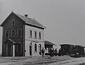
Wallerfangen, station building around 1897 (Archive of the Wallerfangen Local Research Association)

.jpg)
.jpg)
Until 1955, Wallerfangen still had its own rail connection. In 1894 the Saarlouis city council decided to build a standard-gauge , steam-powered small train from Wallerfangen via Saarlouis to Ensdorf . The Wallerfanger stoneware factory was to be connected to the Saar line between Trier and Saarbrücken via Saarlouis. The contract to establish the rail link was signed on April 7, 1894. The approval of the royal Prussian government authority in Trier was issued on December 10, 1895. The construction work for the 10.17 km long route from Ensdorf to Wallerfangen began on September 1, 1896. The first train ran on July 28, 1897, the general commissioning took place on August 1, 1897.
At the time of the start of operations, the small railroad had two locomotives of the Prussian type T 2 . In addition, the Kleinbahn had three two-axle passenger cars, a mail car, four freight cars and two special cars. A third locomotive since 1910 made it possible to separate freight traffic from passenger traffic. In 1921 the line was electrified. Only the stretch from Wallerfangen station to the stoneware factory remained steam-powered. In 1930, goods traffic from the small train station to the factory was stopped. The entire railway operation was given up in 1955.
The line was initially managed by the Berlin-based railway construction and operating company Vering & Waechter . On February 16, 1899, the line was taken over by the Deutsche Eisenbahnbetriebsgesellschaft, which handed over operations to the Saarlouis district in 1918 .
The station building, which has been preserved in Wallerfanger Hauptstrasse to this day, is a two-story brick building with three window axes. In the basement the windows are arched with sandstone walls, in the upper floor they are rectangular. The building is covered by a gable roof, the original verge ornamentation of which is no longer preserved. The front arched portals are no longer accessible. The side entrance shows a small, saddle-covered porch. The small freight yard in exposed framework was removed.
Before the construction of the railroad in Wallerfangen, people had to rely on horse-drawn vehicles for transportation . A changing station for 20 horses was located in a house from 1843 on Hauptstrasse (today Hauptstrasse 34) that still exists today. An inn was also operated in the building.
Saar Bridge
Delayed by the First World War , the first Saar Bridge between Wallerfangen and Dillingen could only be opened to traffic in 1929 by Sir Ernest Wilton , the British President of the Saar Government Commission.
Transportation
The municipal area is networked by several lines of the roundabout companies and connected to the surrounding area.
Airports in the vicinity

There are several airports within a radius of 100 km, of which are particularly worth mentioning:
- Saarbrücken-Ensheim
- Luxembourg-Findel
- Lautzenhausen-Hahn in the Hunsrück
- Saarlouis-Düren as a traffic landing pad for private planes in the Wallerfang district of Düren
- Glider airfield and airfield for powered flight in Diefflen
Shipping
The closest, economically usable shipping route is the Saar. The neighboring Saarhafen Saarlouis / Dillingen has a cargo turnover of more than three million tons per year. It opened in 1988.
The historic Wallerfanger Saarhafen was located in the Wallerfanger Saarengt (today Saaraltarm). Until 1929 there was no bridge crossing over the Saar to Dillingen and Lachten in Wallerfangen . The next Saar Bridge was in Saarlouis . Until the Wallerfanger Saar Bridge was built in 1929, people had to cross the Saar by ferry. With the construction of the Saar Bridge, the infrastructure of Wallerfang was significantly improved. Now there was a cheaper connection to the Dillinger train station and to the production facilities of the Dillinger Hütte .
Water supply
.jpg)


.jpg)
The "Niederlimberg" high-level drinking water tank was put into operation in 1928 for Wallerfangen, Niederlimberg and Beaumarais . The sandstone facade of the building is designed in a mixture of neo-Gothic and crystalline expressionism . Niederlimberg, which was created in 1706, was incorporated into Wallerfangen on April 1, 1936. Beaumarais, which was created when Wallerfangen was destroyed and the city of Saarlouis was founded at the end of the 17th century, was supplied with Niederlimberger drinking water until 1974. Then it was connected to the local drinking water supply as a district of the city of Saarlouis, to which Beaumarais had belonged since 1936. The Niederlimberg elevated drinking water reservoir has three water chambers. In total, it has a capacity of 350 cubic meters. 100 cubic meters of water were earmarked for extinguishing fires. The Saarlouiser Donnerbrauerei was also supplied with drinking water from Niederlimberg. When the population of Niederlimberg, Wallerfangen and Beaumarais increased drinking water consumption (as of April 1, 1936: Wallerfangen, 3,673 inhabitants / Niederlimberg, 240 inhabitants), the storage capacity had to be increased. In 1978 the new high-level drinking water tank "Lothringer Straße" was put into operation above the high-level drinking water tank "Niederlimberg" with a capacity of 2000 cubic meters and the "Niederlimberg" drinking water tank was switched off.
The water supply for the community of Wallerfangen is currently provided by the "Felsberger Straße" waterworks. The districts of Wallerfangen and the Niedaltdorf district of Rehlingen-Siersburg are supplied with water by the "Schäferbruch" waterworks in the Blauloch.
economy
The most important employers in the immediate vicinity of Wallerfang are in the steel industry as well as metalworking companies and the skilled trades. Examples are the Dillinger Hütte , the Bartz works, the Dillinger factory with perforated sheet metal and the NEMAK aluminum foundry. The automotive industry is represented by the Ford works on the Saarlouiser Röderberg. In the luxury food industry, the Trumpf Chocolate factories in Fraulautern and Saarwellingen should be mentioned. Various retail companies also offer numerous jobs. The unemployment rate in the Saarlouis district was 6.1% in July 2020.
fire Department
The voluntary fire brigade of the Wallerfangen community with around 160 members consists of four extinguishing districts:
- Fire fighting district 1: Catfish catching
- Extinguishing zone 2: center
- Fire fighting district 3: Ittersdorf
- Fire fighting district 4: West
The fire brigade has had a marching band since 1951. From 1972 on, female members were also accepted.
In the 17th century, a fire fighting force was organized for the first time in Wallerfangen. Today's volunteer fire brigade was founded on a municipal council resolution of March 14, 1822 on June 3, 1822. The first uniform took place in May 1851. After two large fires in the municipality in 1878 and 1879, it was decided on May 29, 1879 that the to merge municipal fire brigade with the stoneware factory's fire brigade . So you could set up three fire engines after unification. The syringe house was now opposite the entrance to the stoneware factory. On the initiative of Nicolas Adolphe de Galhau, a water pipe with hydrants was laid to provide extinguishing water . In 1981 a new fire station was built on Sportplatzstrasse.
Medical supplies
Hospitals, retirement homes, social service providers
- St. Nikolaus Hospital (specialist clinic for geriatrics and psychiatry)
- Sophienstiftung Wallerfangen (St. Nikolaus Hospital, children's home, old people's home)
- Wallerfanger Haus Christophorus of the Caritas supporting company Saarbrücken (child and youth welfare institution)
In addition, there are two clinics in the neighboring town of Saarlouis:
- Marienhausklinikum St. Elisabeth
- DRK hospital
Red Cross
The Wallerfangen medical column, founded in 1901, became the local Red Cross association after the First World War . In 1937 the "Patriotic Women's Association", founded in 1925, joined under its local chairman Martha von Papen . With the beginning of the Second World War, the club was moved to Schlangenbad and Bad Schwalbach . From there, the male members of the association were deployed on several front lines, the female members in field and home hospitals. In 1960 a youth group was founded.
Pharmacies
There has been a pharmacy in Wallerfangen since 1912 (today Park Pharmacy, Hauptstrasse 39). The facility has been in the same building since it was founded, which has, however, been expanded several times and structurally changed significantly over the years. Another pharmacy (Limberg pharmacy) opened in 1978 on Saarstrasse in the building of the former casino of the stoneware factory.
sport and freetime
.jpg)

.jpg)
.jpg)
The municipality maintains several sports and leisure activities:
swimming pool
Wallerfangen has a heated outdoor pool near the forest. The pool includes four different pools (diving, sports, non-swimmers and paddling pools) and has 300 parking spaces. In addition, other sports are available: soccer field, volleyball, basketball, children's play equipment, matschbach. The bathroom offers a steam sauna and a dining area. Seniors and handicapped accessible access to the pools are available. There is a shower and toilet room for wheelchair users.
hike
Two premium hiking trails ("Hirn-Gallenberg-Tour" in Rammelfangen and the "Gisinger" in Gisingen) lead through the Saargau. Another premium hiking trail is currently being built, which will run from the Leidingen district under the title "Grenzblickweg" along the German-French border.
tennis
In Wallerfanger Blaulochstraße there is a tennis facility with two outdoor and six indoor courts.
golf
The 18-hole championship course was designed in 1961 by the golf course architect Donald Leslie Harradine and revised on the first 9 holes in 2001. Moderately difficult playing conditions exist on the hilly terrain of around 50 hectares.
Powered flight
The airfield in Düren is set up for motor planes and motor gliders. Skydiving is also offered.
Model flight
The Rammelfanger model airfield is approved for motor models, sailors, electric models and turbine jets. The airfield has a length of 170 m and a width of 75 m.
campsite
The Wallerfangen Camping Park in the vicinity of the Wallerfanger outdoor pool offers 300 parking spaces.
societies
In Wallerfangen, over 100 registered associations are dedicated to the areas of culture and sport.
One of the traditional Wallerfang associations is the men's choir "Gesellschaft der Liedertafel zu Wallerfangen", founded in 1839. The association was banned twice for a long time by the authorities in the context of the 1848 revolution , as revolutionary activities of the members were suspected. The association originally consisted of administrators from the stoneware factory, who co-opted new members after voting with black and white balls . On the occasion of the 100th anniversary, the association was awarded the Zelter plaque in gold in 1939 . After the Second World War, the men's choir "Men's Quartet Wallerfangen" founded in 1922 was incorporated into the Liedertafel. Josef Sibille headed the association between 1921 and 1975. In 2014 the Wallerfanger Liedertafel celebrated its 175th anniversary.
Another traditional cultural association is the "Concordia Wallerfangen Music Association", founded in 1851. It was founded as the works chapel of the stoneware factory on the initiative of Charles Villeroy (grandson of the company's founder Nicolas Villeroy) and was named "Concordia" in 1919. The 100th anniversary was celebrated in 1951.
The Wallerfanger local chapter of in 1907 at the nearby Litermont called in life Saar Forest Association was founded in the 1912th In 2012, the Wallerfang local group celebrated its 100th anniversary.
The Wallerfangen sports club has existed since 1920. In 1967, the club founded under the name "FC Blau-Weiß Wallerfangen" merged with the Wallerfang local branch of the Catholic sports association Deutsche Jugendkraft, founded in 1958 . From then on, the association was called "SV Wallerfangen 1920 eV" A sports complex with a lawn, clubhouse and changing rooms was inaugurated on August 15, 1978. A first women's soccer team was formed in 1981.
Personalities
Daughters and sons of the church
(in chronological order)
- Friedrich von Wallerfangen (*…; † before 1346), Dean of St. Arnual
- Laudwein Flörchinger (* around 1600; † between 1639 and 1646), lawyer and lieutenant general, 1633 appointment as lieutenant general of the Bellistum German-Lorraine
- Ferdinand Heill (* probably in Wallerfangen; † January 21, 1710 in Saarlouis), Mayor of Saarlouis
- Philipp Müller (born February 13, 1811 - † November 27, 1893 there), engraver , illustrator and caricaturist
- Nicolas Adolphe de Galhau (born February 6, 1814 - November 23, 1889), landowner, entrepreneur and politician, made honorary citizen of the community in 1850
- Ernest Villeroy (born April 2, 1843 in Wallerfangen; † November 6, 1908 in Wallerfangen) factory owner
- Elisabeth Zillken (* July 8, 1888; † November 28, 1980), politician ( Center Party ), MdR , MdL
- Nora Scheitgen (born January 19, 1890; † unknown), school director and author
- Julius Reimsbach (born August 30, 1895 in Niederlimberg; † July 12, 1970 in Wallerfangen), organ builder
- Anna Zillken (born July 17, 1898 - † February 12, 1966), school director and author
- Carl Zenner (born June 11, 1899 - June 16, 1969), politician ( NSDAP ) and SS brigad leader, MdR
- Johann Klein (born January 9, 1902 - † May 25, 1976), trade unionist and politician ( CVP , CDU ), Member of the Bundestag
- Hermann Mathias Görgen (* December 23, 1908 - May 3, 1994), politician ( CVP , CSU ), Member of the Bundestag
- Hilde Hetzler-Wendler, b. Wendler (* 1918; † 1969 in Wallerfangen), painter and ceramicist
- Franz-Josef Reichert (born May 21, 1934 † 15 April 2012), art historian , journalist and program director radio of the Saarland Radio
Personalities connected with catfish
(in chronological order)
- Giselbert , Count of the County of Wallerfangen , son of Count Siegfried I of Luxembourg , older brother of Kunigunde of Luxembourg and brother-in-law of Emperor Heinrich II.
- Phillip Jakob von Helmstatt, Lord of Felsberg (* May 21, 1461 - December 17, 1558), buried in the Augustinian Church in Wallerfangen
- Johann von Bockenheim (* approx. 1530 - † February 1584), mountain judge and ducal Lorraine rent master in Wallerfangen
- Christoph von Kriechingen (* around 1540 in Kriechingen; † 1622), Baron von Kriechingen, 1604-1622 bailiff for the Ballei Deutsch-Lorraine in Wallerfangen,
- Laudwein von Bockenheim (* around 1560; † before February 19, 1628), mountain judge and ducal-Lorraine rent master in Wallerfangen
- Peter Ernst von Kriechingen (* around 1570 at Kriechingen Castle, † 1633 in Kriechingen), Count of Kriechingen
- Sébastien le Prestre de Vauban (~ May 15, 1633 in St. Léger-de-Foucheret (today: St-Léger-Vauban); † March 30, 1707 in Paris), fortress builder, Commissaire Général des Fortification de France, January to February 1680 stay in Wallerfangen and there preparation of the building instructions for the fortress town Saarlouis
- Jean-Nicolas Dussart de Vigneulles (* before 1643 presumably in Thionville; † January 19, 1713 in Saarlouis), bailiff and master builder, organization of the resignation of Wallerfangen and work as "Ingénieur du roy" (fortress builder and entrepreneur) in the fortress construction in Saarlouis
- Guy Creuzet de Richerand (born July 15, 1652 in Chaulgnes, † October 29, 1704 in Saarlouis), officer and engineer, preparation of the appraisal report for the houses and properties in Wallerfangen before resignation (together with François de Voigny)
- Johann Huart (*…; † before March 6, 1636), lawyer and lieutenant general of the Ballei Deutsch-Lorraine in Wallerfangen
- Jacques Pierrard de Coraille (* around 1670 in Metz; † 1724/25 in Saarbrücken), sculptor of the baroque Stations of the Cross on Limberg
- Nicolas Villeroy (born May 14, 1759 in Metz; † December 28, 1843 in Wallerfangen), factory owner, founder of the Wallerfang ceramic factory
- Nicolas Theodore Antoine Adolphe de Lasalle (born November 11, 1762 in Saarlouis; † March 3, 1803 in Niederlimberg), landowner, judge, politician, owner of the castle in Niederlimberg-Wallerfangen with lands, 1789 member of the 3rd class in the assembly of the Estates General in Paris, 1790-1791 President of the Saarlouis district, May 1793 election to Maire by the active citizens of Wallerfangen
- Johann Leonhard Wenzeslaus Schily (born September 28, 1808 in Prüm; † November 15, 1869 in Trier), 1839 notary in Wallerfangen, co-founder of the poor association in Wallerfangen, 1848 organizer of popular assemblies, 1849 member of the Prussian House of Representatives
- Peter Cornelius (* December 24, 1824 - October 26, 1874), poet-composer of the Romantic era, nephew of the painter Peter von Cornelius , spent eight months in Wallerfangen with his brother-in-law Johann Schily in 1853, where he composed six songs (Opus 1 )
- Charles-Nicolas Peaucellier (born June 16, 1832; † 1913), the inventor of the inverse , was reburied in 1929 from the Dillinger Defrance crypt in Wallerfangen
- Franz Georg Himpler (born May 14, 1833 in Ottweiler; † September 13, 1916 in Hoboken, USA), architect of the Wallerfanger Katharinenkirche and the former Wallerfanger Josephskapelle (now in Mettlach)
- Theodor Liebertz (born November 20, 1869 in Düren, † February 7, 1959 in Wallerfangen), Wallerfang Deputy Director and local researcher
- Franz von Papen (born October 29, 1879; † May 2, 1969), politician (Center Party), Reich Chancellor , landowner, appointed honorary citizen of the community in 1933, buried in the Wallerfanger cemetery
- Andreas Mailänder (born October 26, 1888 in Gresaubach; † October 1981 in Saarlouis), teacher and local historian, researcher of the town history of Wallerfang
- Karl Hanus (July 18, 1927 in Saarlouis; † January 19, 2013 in Saarlouis), architect of the Wallerfang town hall in the years 1959-1961
- Jo Enzweiler (born April 16, 1934 in Merzig -Büdingen), visual artist and art pedagogue , founder of the Saarlouis Institute for Contemporary Art in Saarland at the Saar College of Fine Arts , lives and works in Wallerfangen
- Oswald Hiery (born May 21, 1937 in Ensdorf; † July 6, 2016), artist, buried on July 13, 2016 in the Wallerfangen cemetery
- Josef Hoff († 1972), 1941–1966 pastor of the parish of St. Katharina , honorary citizen of the parish, his grave is in the Salvatorkirche in the Wallerfang district of St. Barbara
- Oskar Lafontaine (born September 16, 1943), politician ( SPD ), Prime Minister of the Saarland, Member of the State Parliament, Federal Minister of Finance , Member of the Bundestag, lived in Wallerfangen-Oberlimberg until March 30, 2012
- Alfred Gulden (born January 25, 1944), writer, lives in Wallerfangen and Munich
- François Villeroy de Galhau (born February 24, 1959), bank manager and since November 2015 Governor of the Banque de France , son of Claude Villeroy de Galhau (1931-2017) and Odile de la Lande de Calan
literature
- Beatrix Adler: Wallerfanger earthenware - history and products of the Villeroy Vaudrevange manufactory (1791–1836) and the earthenware factory Villeroy & Boch Wallerfangen (1836–1931), 2 volumes, Saarbrücken 1995.
- Wolfgang Adler, Gerd Weisgerber : Catfish catch. In: Reallexikon der Germanischen Altertumskunde (RGA). 2nd Edition. Volume 33, Walter de Gruyter, Berlin / New York 2006, ISBN 3-11-018388-9 , pp. 143-149.
- Wolfgang Adler : Excavations in the center of the medieval town of Wallerfangen, Preservation of Monuments in Saarland, Annual Report 2011 (2012), pp. 78–80.
- Wolfgang Adler: King lets the city tear down, Archeology Germany 2012, issue 2, p. 53f.
- Wolfgang Adler: On the roots of the medieval town of Wallerfangen, emergency excavation at the corner of Hauptstrasse and Villeroystrasse, preservation of monuments in Saarland, annual report 2012 (2013), pp. 72–74.
- Wolfgang Adler: Old explored - new built, The excavations during the construction of the Wallerfangen branch of the Kreissparkasse Saarlouis 2011 and 2012, with contributions by B. Fecht, S. Klapdohr, J. Naumann and R. Schreiber (exhibition catalog), Saarlouis 2013.
- Wolfgang Adler: A sacrifice for Saarlouis. During excavations in Wallerfangen, remnants of the parish church and the old cemetery were found, in: Saargeschichten 4/2013, pp. 25–29.
- Wolfgang Adler: Insights into the center of the medieval town of Walderfingen, excavations on the occasion of the new building of the Wallerfangen Sparkasse branch in 2001 and 2012, in: Archäologietage Otzenhausen, Volume 1, Archeology in the Greater Region, International Symposium on Archeology in the Greater Region at the European Academy Otzenhausen, 7 . – 9. March 2014, ed. Michael Koch, Nonnweiler 2015, pp. 275-278.
- Markus Battard: Wallerfangen - A journey through time in pictures, 2nd revised edition, Dillingen / Saar 2012.
- Rudolf Echt : Landfilling of the late Urnfield period, heights fortifications and magnificent grave of the Hallstatt period in Wallerfangen, Saarlouis district, in: R. Echt (Ed.): Contributions to the Iron Age and the Gallo-Roman period in the Saar-Moselle region, Saarbrücken studies and materials for Altertumskunde 9, Bonn 2003, pp. 29–73.
- Rudolf Echt: The grave decorations of the Celtic princess von Wallerfangen - from the pond into the treasury, booklet accompanying the exhibition from April 27 to July 8, 2001 in the Wallerfangen Museum of Local History, Wallerfangen 2001.
- Rudolf Echt: From Wallerfangen to Waldalgesheim, a contribution to late Hallstatt and early La Tène goldsmith work, Saarbrücker Studies and Materials for Antiquity 3 (Bonn 1994) (with W.-R. Thiele).
- Rainer Glatigny: In memory of the dead - the living as a warning: The fallen from Catfish in the Second World War 1939–1945 , 2010.
- Henri Hiegel: Le Baillage d´Allemagne de 1600 à 1636, 2 volumes, Saargemünd 1961/1968.
- Gernot Karge: Adolf von Galhau'schen Sophienstiftung, on the occasion of the 150th anniversary of the sisters of St. Karl Borromeo, a report on the poor and nursing in Wallerfangen, St. Nikolaus-Hospital Wallerfangen, 150 years of Borromean women in Wallerfangen, ed. from the Adolf von Galhau'schen Sophienstiftung, Dillingen o. J. (1998).
- Gernot Karge: Catfish catching in old views, Zaltbommel 1982.
- Hans Peter Klauck: The inhabitants of the old town Wallerfangen before 1687, ed. by Gernot Karge on behalf of the Association for Local Studies in the District of Saarlouis eV, Saarlouis 2004.
- Hans-Peter Klauck: The residents of Wallerfangen, Niederlimberg and St. Barbara, 1800–1900, Saarlouis 2008.
- Theodor Liebertz: Wallerfangen and its history , Wallerfangen 1953.
- Hermann Maisant: The Saarlouis district in prehistoric times, Saarlouis 1971.
- Katharina Milkovic: Wallerfangen, Canal Construction and Urban Archeology, in: Preservation of Monuments in Saarland, Annual Report 2014, ed. from the State Monuments Office in the Ministry of Education and Culture, Saarbrücken 2015, pp. 80–82.
- Guido Müller: The Villeroy and de Galhau families in Saarland, reports from the Association for Local Studies in the Saarlouis District. V., 6th special volume, Saarlouis 1991.
- Hilarion Rieck: The Oberlimberg near Wallerfangen and its pilgrimage, Saarlouis 1935.
- Saarforschungsgemeinschaft (ed.): The art monuments of the Ottweiler and Saarlouis districts, edited by Walter Zimmermann, 2nd, unchanged edition from 1934, Saarbrücken 1976, pp. 294–297.
- Eckard Sander: Villeroy de Galhau Castle, in: The most beautiful palaces and castles in Saarland, Gudensberg-Gleichen 1999, pp. 80–81.
- Edith Thissen: Wallerfangen, Niederhoffen Castle, Villeroy de Galhau Castle, The "Black Castle", Hofgut von Papen, in: Castles and Palaces on the Saar, ed. v. Joachim Conrad and Stefan Flesch, 3rd edition, Saarbrücken 1993, p. 261ff.
- Alfred Weyhmann: Mining on copper glaze (azure) at Wallerfangen ad Saar under the Lorraine dukes (1492 to 1669), Wirtschaftsgeschichtliche Studien, No. 1, Saarbrücken 1911.
- Peter Winter: New plan of the city Wallerfangen (Vaudrevange) from the year 1679 surfaced, in: Our home - bulletin of the district Saarlouis for culture u. Landschaft, 38, 2013, issue 2, pp. 45–50.
Web links
- Website of the municipality of Wallerfangen
- Literature on catfish catching in the Saarland bibliography
- Wallerfangen Local Research Association and Local History Museum
- Working group “Alemannia Judaica”: On the history of the Jewish community of Wallerfangen
- Link catalog on catfish catching at curlie.org (formerly DMOZ )
supporting documents
- ↑ Saarland.de - Official population figures as of December 31, 2019 (PDF; 20 kB) ( help ).
- ^ Helga Schneider: The natural space units on sheet 159, Saarbrücken, Geographische Landesaufnahme, 1: 200,000, Bonn-Bad Godesberg 1972, p. 105.
- ↑ Herbert Liedtke, Karl-Heinz-Hepp, Christoph Jentsch: The Saarland in map and aerial photo, A contribution to regional studies, ed. from the Land Surveying Office of Saarland, Neumünster 1974, p. 13.
- ^ Helga Schneider: The natural space units on sheet 159: Saarbrücken, Geographische Landesaufnahme 1: 200000, in: Handbuch der Naturräumlichen Gliederung Deutschlands, Bonn-Bad Godesberg 1972.
- ↑ Robert Schuler: Dasl Land der Kelten around the Hunnenring of Otzenhausen, with contributions by Thomas Fritsch, Andrei Miron, Walter Reinhard and Mathias Wiegert, Hochwälder Hefte zur Heimatgeschichte, ed. from the association for local history Nonnweiler e. V., 20th year, issue 40, May 2000, anniversary edition, Nonnweiler, 2nd edition 2003, pp. 196–197.
- ↑ Martin Born: Geographical regional studies of the Saarland, Saarbrücken 1980, p. 14.
- ^ Heinrich Schmitthenner: The surface forms of the step landscape between Maas and Mosel, Stuttgart 1923.
- ^ Herbert Wilhelmy: Geomorphology in key words, Volume II, Exogenous Morphodynamics, Weathering - Ablation - Valley and surface formation, Contributions to general geography, 3rd, revised edition, Zug 1977, pp. 187-189.
- ^ Martin Born: Geographische Landeskunde des Saarlands, Saarbrücken 1980, pp. 24–30, 38–39.
- ↑ Friedrich Fischer: Contributions to the morphology of the river system of the Saar, dissertation to obtain the doctorate of the Philosophical Faculty of the University of Saarland (work from the Geographical Institute of the University of Saarland), Saarbrücken 1957, pp. 56-57.
- ^ Helga Schneider: The natural space units on sheet 159: Saarbrücken, Geographische Landesaufnahme 1: 200000, in: Handbuch der Naturräumlichen Gliederung Deutschlands, Bonn-Bad Godesberg 1972, pp. 37-38.
- ↑ Heinz Quasten: Naturräumlicher Abriß (sic), in: Fred Oberhauser: Das Saarland, art, culture and history in the triangle between Blies, Saar and Mosel (Dumont art travel guide), Cologne 1992, pp. 340–353, here p. 346 .
- ↑ Heinz Quasten: Naturräumlicher Abriß (sic), in: Fred Oberhauser: Das Saarland, art, culture and history in the triangle between Blies, Saar and Mosel (Dumont art travel guide), Cologne 1992, pp. 340–353, here p. 345 .
- ↑ Heinz Quasten: Naturräumlicher Abriß (sic), in: Fred Oberhauser: Das Saarland, art, culture and history in the triangle between Blies, Saar and Mosel (Dumont art travel guide), Cologne 1992, pp. 340–353, here p. 346 -347.
- ↑ Martin Born: Geographische Landeskunde des Saarland, Saarbrücken 1980, pp. 79–89.
- ↑ Herbert Liedtke, Karl-Heinz-Hepp, Christoph Jentsch: The Saarland in map and aerial photo, A contribution to regional studies, ed. from the Landesvermessungsamt des Saarlandes, Neumünster 1974, pp. 70–71
- ^ Helga Schneider: The natural space units on sheet 159, Saarbrücken, Geographische Landesaufnahme, 1: 200.000, Bonn-Bad Godesberg 1972, pp. 104-106, p. 113.
- ↑ https://de.climate-data.org/location/117787/ , accessed on January 31, 2017.
- ↑ accessed on January 31, 2017. ( Page no longer available , search in web archives ) Info: The link was automatically marked as defective. Please check the link according to the instructions and then remove this notice.
- ↑ wahlresult.saarland.de - final result of the 2019 municipal council elections , accessed on August 4, 2019
- ^ Markus Battard: Wallerfangen - A journey through time in pictures, 2nd revised edition, Dillingen / Saar 2012, p. 130.
- ↑ Markus Battard: Wallerfangen - A journey through time in pictures, 2nd revised edition, Dillingen / Saar 2012, pp. 10-13, p. 142.
- ↑ Markus Battard: Wallerfangen - A journey through time in pictures, 2nd revised edition, Dillingen / Saar 2012, pp. 88–92.
- ↑ http://typo3.lpm.uni-sb.de/gs-wallerfangen/unsere-schule/willkommen/geschichte-chronik/ , accessed on January 7, 2016.
- ↑ Hermann Lehne; Horst Kohler: Coat of Arms of the Saarland (Saarbrücken 1981; ISBN 3-922807-06-2 ), p. 166.
- ↑ Theodor Liebertz: Wallerfangen and his story, Wallerfangen 1953, pp. 14-15.
- ↑ Markus Battard: Wallerfangen - A journey through time in pictures, 2nd revised edition, Dillingen / Saar 2012, pp. 163–164.
- ↑ Markus Battard: Wallerfangen - A journey through time in pictures, 2nd revised edition, Dillingen / Saar 2012, pp. 108–113.
- ↑ http://wallerfangen.slc-technik.de/tourismus-kultur-sport/historisches-museum/ , accessed on December 29, 2016.
- ↑ Archived copy ( memento of the original dated December 29, 2016 in the Internet Archive ) Info: The archive link was inserted automatically and has not yet been checked. Please check the original and archive link according to the instructions and then remove this notice. , accessed December 29, 2016.
- ↑ Marlen Dittmann: The building culture in Saarland, series Saarland booklets No. 4, ed. from the Institute for Regional Studies in Saarland, Saarbrücken 2011.
- ↑ Rainer Darimont: An Inconvenient Architectural Monument? New town hall Wallerfangen, in: Our home, bulletin of the Saarlouis district for culture and landscape, No. 2, 2013.
- ↑ Oranna Dimmig: Art in Public Space, Saarland, Volume 3, Saarlouis district, 1945-2006, ed. by Jo Enzweiler, Saarbrücken 2009, p. 381.
- ^ Marlen Dittmann: Karl Hanus, Buildings and Projects 1957-1993 (edited by Hanus and Giebel), Dillingen 1994, pp. 20, 109.
- ↑ Beatrix Adler: Wallerfanger earthenware - history and products of the Villeroy Vaudrevange manufactory (1791–1836) and the earthenware factory Villeroy & Boch Wallerfangen (1836–1931), 2 volumes, Saarbrücken 1995, volume 1, text, pp. 104–106.
- ↑ Oranna Dimmig: Art in Public Space, Saarland, Volume 3, Saarlouis district, 1945-2006, ed. by Jo Enzweiler, Saarbrücken 2009, p. 380.
- ↑ Oranna Dimmig: Art in Public Space, Saarland, Volume 3, Saarlouis district, 1945-2006, ed. by Jo Enzweiler, Saarbrücken 2009, p. 381.
- ↑ http://typo3.lpm.uni-sb.de/gs-wallerfangen/unsere-schule/willkommen/geschichte-chronik/ , accessed on January 7, 2017.
- ↑ http://wallerfangen.slc-technik.de/bildung/kugtagesstaetten/ , accessed on December 29, 2016.
- ↑ http://wallerfangen.slc-technik.de/bildung/schulen/grundschulen/ , accessed on December 29, 2016.
- ↑ http://wallerfangen.slc-technik.de/bildung/allgemeinbildende-schulen/gemeinschaftsschule/ , accessed on December 29, 2016.
- ↑ http://typo3.lpm.uni-sb.de/jhw-saarlouis/index.php?id=91 , accessed on May 27, 2016.
- ↑ http://wallerfangen.slc-technik.de/bildung/volkshochschule/ , accessed on December 29, 2016.
- ↑ http://wallerfangen.slc-technik.de/bildung/musikschule/ , accessed on December 29, 2016.
- ↑ Hans Peter Buchleitner: Cultural Reconstruction in Saarland, Text and Image, Volume II, additions to the church structure in Saarbrücken and in the parishes of both Christian denominations of the Saarlouis and Merzig-Wadern districts, Saarbrücken 1959, p. 26.
- ^ Archive of the Sonnental House
- ^ Wolfgang Götz: Neuer Kirchenbau im Saarland (II), in: Saarheimat, 10th year, issue 1, 1966, pp. 10-17.
- ↑ Bastian Müller: Architecture of the Post-War Period in Saarland, Saarbrücken 2011 (Preservation of Monuments in Saarland 4), p. 137.
- ↑ Wolfgang Götz: New Church Building in Saarland (II), Saarheimat, magazine for culture, landscape, folkism, 10th year 1966, pp. 10-17.
- ^ Institute for Contemporary Art in Saarland, archive, Wallerfangen holdings, St. Michael Youth Church (Dossier K 830)
- ↑ http://wallerfangen.slc-technik.de/bildung/tagungs-und-bildungsstaette/ , accessed on December 29, 2016.
- ^ Markus Battard: Wallerfangen - A journey through time in pictures, 2nd revised edition, Dillingen / Saar 2012, pp. 114–115.
- ↑ http://wallerfangen.slc-technik.de/bildung/bibliothek/ , accessed on December 29, 2016.
- ↑ Manfred Kostka: History of the parish Dillingen from its beginnings to the division in 1935, in: Katholisches Bildungswerk Dillingen-Nalbach e. V. (Ed.): 100 years of Saardom, Holy Sacrament Dillingen, 1000 years of the Dillingen parish, commemorative publication for the anniversary of the church consecration on April 25, 2013, Dillingen 2012. pp. 17–65, here p. 21.
- ↑ WALLERFANGEN (ST. BARBARA, BEDERSDORF, DÜREN, GISINGEN, IHN, ITTERSDORF, KERLINGEN, LEIDINGEN, OBERLIMBERG, RAMMELFANGEN), CATHOLIC CHURCHES , accessed on May 27, 2016.
- ↑ http://www.wallerfangen-typo3.de/startseite/kirche/
- ↑ http://www.alemannia-judaica.de/wallerfangen_synagoge.htm#Zur%20Geschichte%20der%20j%C3%BCdischen%20Gemeinde , accessed on January 9, 2017.
- ↑ Wolfgang Adler: Old explored - new built, The excavations during the construction of the Wallerfangen branch of the Kreissparkasse Saarlouis 2011 and 2012, with contributions by B. Fecht, S. Klapdohr, J. Naumann and R. Schreiber (exhibition catalog), Saarlouis 2013.
- ↑ Wolfgang Adler: Excavations in the center of the medieval town of Wallerfangen, Preservation of monuments in Saarland, annual report 2011 (2012), pp. 78–80.
- ↑ Wolfgang Adler: King lets the city tear down, Archeology Germany 2012, issue 2, p. 53f.
- ↑ Wolfgang Adler: On the roots of the medieval town of Wallerfangen, emergency excavation on the corner of Hauptstrasse and Villeroystrasse, preservation of monuments in Saarland, annual report 2012 (2013), pp. 72–74.
- ↑ Wolfgang Adler: A sacrifice for Saarlouis. During excavations in Wallerfangen, remnants of the parish church and the old cemetery were found, in: Saargeschichten 4/2013, pp. 25–29.
- ↑ Wolfgang Adler: Insights into the center of the medieval town of Walderfingen, excavations on the occasion of the new building of the Wallerfangen Sparkasse branch in 2001 and 2012, in: Archäologietage Otzenhausen, Volume 1, Archeology in the Greater Region, International Symposium on Archeology in the Greater Region at the European Academy Otzenhausen, 7th-9th March 2014, ed. Michael Koch, Nonnweiler 2015, pp. 275-278.
- ↑ http://www.sol.de/titelseite/topnews/Friedhof-Wallerfangen-Archaeologen-enthaben-alten-Friedhof-von-Wallerfangen;art26205,3624533 , accessed on January 21, 2016.
- ↑ Markus Battard: Wallerfangen - A journey through time in pictures, 2nd revised edition, Dillingen / Saar 2012, pp. 75–87.
- ↑ Margarethe Thinnes: Road crosses and wayside shrines in Saarland, Saarbrücken 1985, p. 42.
- ↑ Oranna Dimmig: Art in Public Space, Saarland, Volume 3, Saarlouis district after 1945, essays and inventory, ed. by Jo Enzweiler, Saarbrücken 2009, p. 382.
- ↑ Rainer Darimont: Medieval burial places in Wallerfangen, part 1 and 2, on the page: http://www.verein-fuer-heimatforschung-wallerfangen.de/# , accessed on April 7, 2016.
- ↑ Rainer Darimont: The Wallerfangen Cemetery, on the page: http://www.verein-fuer-heimatforschung-wallerfangen.de/# , accessed on April 9, 2016.
- ↑ Johannes Werres: Article "New War Memorial for Wallerfangen", in: Saarbrücker Zeitung, June 6, 2013, http://www.saarbruecker-zeitung.de/saarland/saarlouis/Kriegerdenkmal-Wallerfangen-Weltkrieg-Saarlouis-Aufmacher;art2807, 4809109 , accessed April 9, 2016.
- ↑ Johannes A. Bodwing: Article "Memory without Pathos", in: Saarbrücker Zeitung, April 12, 2014, http://www.saarbruecker-zeitung.de/saarland/saarlouis/Gedenkstaette-Wallerfangen-Friedhof-Kriegsgraeber;art2807,5223632 , accessed April 9, 2016.
- ^ Hilarion Rieck: The Oberlimberg near Wallerfangen and his pilgrimage, Saarlouis 1935, p. 4.
- ^ Hilarion Rieck: The Oberlimberg near Wallerfangen and his pilgrimage, Saarlouis 1935, pp. 6-7.
- ↑ Saarforschungsgemeinschaft (Ed.): The art monuments of the Ottweiler and Saarlouis districts, edited by Walter Zimmermann, 2nd, unchanged edition from 1934, Saarbrücken 1976, p. 243.
- ^ Hilarion Rieck: The Oberlimberg near Wallerfangen and his pilgrimage, Saarlouis 1935, pp. 7–8.
- ^ Hilarion Rieck: The Oberlimberg near Wallerfangen and his pilgrimage, Saarlouis 1935, pp. 10-11.
- ^ Hilarion Rieck: The Oberlimberg near Wallerfangen and his pilgrimage, Saarlouis 1935, p. 12.
- ^ Theodor Liebertz: Wallerfangen and his story, Wallerfangen 1953, p. 289.
- ^ Margarethe Thinnes: wayside crosses and wayside shrines in Saarland, Saarbrücken 1985, pp. 214–215.
- ↑ Georg Baltzer: Historical Notes on the City of Saarlouis and its Immediate Surroundings, Part One: Historical Notes on the City of Saarlouis, Part Two: Historical Notes on the Immediate Surroundings of Saarlouis, reprint of the edition from 1865, Dillingen / Saar 1979, Part I. , P. 98.
- ↑ Severin Delges: History of the Catholic Parish St. Ludwig in Saarlouis, Saarlouis-Lisdorf 1931, extension by a second part by Heinrich Unkel in 1952, extension by a third part by Marga Blasius in 1985, part I, p. 48.
- ^ Theodor Liebertz: Wallerfangen and his story, Wallerfangen 1953, pp. 285–292.
- ^ Hilarion Rieck: The Oberlimberg near Wallerfangen and his pilgrimage, Saarlouis 1935, pp. 15-16.
- ↑ Margarethe Thinnes: wayside crosses and wayside shrines in Saarland, Saarbrücken 1985, p. 259.
- ↑ Margarethe Thinnes: wayside crosses and wayside shrines in Saarland, Saarbrücken 1985, p. 122.
- ^ Aloys Schulte : History of medieval trade and traffic between West Germany and Italy excluding Venice, 2 volumes, Duncker & Humblot, Leipzig 1900, (reprint: Duncker & Humblot, Berlin 1966).
- ^ Aloys Lehnert: History of the City of Dillingen Saar, Dillingen 1968, pp. 19-21.
- ↑ Markus Battard: Wallerfangen - A journey through time in pictures, 2nd revised edition, Dillingen / Saar 2012, pp. 69–74.
- ↑ Markus Battard: Wallerfangen - A journey through time in pictures, 2nd revised edition, Dillingen / Saar 2012, p. 131.
- ^ Aloys Lehnert: History of the city of Dillingen / Saar, Dillingen 1968, pp. 544-547.
- ↑ Free travel to the world's markets - ports in the center of Europe ( Memento of the original from June 8, 2009 in the Internet Archive ) Info: The archive link was automatically inserted and not yet checked. Please check the original and archive link according to the instructions and then remove this notice. Saarhafen website, accessed on July 29, 2010.
- ↑ Markus Battard: Wallerfangen - A journey through time in pictures, 2nd revised edition, Dillingen / Saar 2012, pp. 123–125.
- ↑ http://wallerfangen.slc-technik.de/rathaus/wasserleitungs Zweckverband-gau-sued /, accessed on April 19, 2017.
- ↑ https://statistik.arbeitsagentur.de/Auswahl/raeumlicher-Geltungsbereich/Politische-Gebietsstruktur/Kreise/Saarland/10044-Saarlouis.html , accessed on August 11, 2020.
- ↑ http://wallerfangen.slc-technik.de/startseite/feuerwehr/ , accessed on December 29, 2016.
- ↑ Markus Battard: Wallerfangen - A journey through time in pictures, 2nd revised edition, Dillingen / Saar 2012, p. 166.
- ↑ Markus Battard: Wallerfangen - A journey through time in pictures, 2nd revised edition, Dillingen / Saar 2012, pp. 153–156.
- ↑ Markus Battard: Wallerfangen - A journey through time in pictures, 2nd revised edition, Dillingen / Saar 2012, p. 152.
- ↑ Markus Battard: Wallerfangen - A journey through time in pictures, 2nd revised edition, Dillingen / Saar 2012, pp. 181–182.
- ↑ http://wallerfangen.slc-technik.de/tourismus-kultur-sport/freizeit-sport-sehenswerte/ , accessed on December 29, 2016.
- ↑ http://wallerfangen.slc-technik.de/fileadmin/wallerfangen/medien/02_rathaus/Amtsblatt/2013/Vereinsliste_22-08-2016_01.pdf , accessed on December 29, 2016.
- ↑ Markus Battard: Wallerfangen - A journey through time in pictures, 2nd revised edition, Dillingen / Saar 2012, pp. 157–160.
- ^ Markus Battard: Wallerfangen - A journey through time in pictures, 2nd revised edition, Dillingen / Saar 2012, pp. 161–162.
- ↑ Markus Battard: Wallerfangen - A journey through time in pictures, 2nd revised edition, Dillingen / Saar 2012, p. 165.
- ↑ Markus Battard: Wallerfangen - A journey through time in pictures, 2nd revised edition, Dillingen / Saar 2012, pp. 167–168.
- ↑ Archived copy ( memento of December 10, 2016 in the Internet Archive ), accessed on December 10, 2016.
- ↑ Guido Müller: Flörchinger - Florange, an important family of officials from Wallerfang in the 17th century, in: Our home, 9th year, No. 1 (1984), pp. 26-38.
- ↑ Archived copy ( memento of December 10, 2016 in the Internet Archive ), accessed on December 10, 2016.
- ↑ Archived copy ( memento of December 10, 2016 in the Internet Archive ), accessed on December 10, 2016.
- ↑ Archived copy ( memento of December 10, 2016 in the Internet Archive ), accessed on December 10, 2016.
- ↑ Bernhard H. Bonkhoff: Historical Organs in Saarland, Regensburg 2015, pp 286-287.
- ↑ Archived copy ( memento of December 10, 2016 in the Internet Archive ), accessed on December 10, 2016.
- ↑ Jo Enzweiler (Ed.): Art in Public Space Saarland, Volume 1, Saarbrücken, district mid 1945 to 1996, essays and documentation, Saarlouis 1997, p. 370.
- ↑ Archived copy ( memento of December 10, 2016 in the Internet Archive ), accessed on December 10, 2016.
- ↑ Archived copy ( memento of December 10, 2016 in the Internet Archive ), accessed on December 10, 2016.
- ↑ Archived copy ( memento of December 10, 2016 in the Internet Archive ), accessed on December 10, 2016.
- ↑ Archived copy ( memento of December 10, 2016 in the Internet Archive ), accessed on December 10, 2016.
- ↑ Archived copy ( memento of December 10, 2016 in the Internet Archive ), accessed on December 10, 2016.
- ↑ Archived copy ( memento of December 10, 2016 in the Internet Archive ), accessed on December 10, 2016.
- ↑ Archived copy ( memento of December 10, 2016 in the Internet Archive ), accessed on December 10, 2016.
- ↑ Archived copy ( memento of December 10, 2016 in the Internet Archive ), accessed on December 10, 2016.
- ↑ Guido Müller: The Lieutenant General of the German Ballei Johann Huart from Wallerfangen - an eminent lawyer, in: Our home, 18th year, No. 1 (1993), pp. 20-24.
- ↑ Archived copy ( memento of December 10, 2016 in the Internet Archive ), accessed on December 10, 2016.
- ↑ Archived copy ( memento of December 10, 2016 in the Internet Archive ), accessed on December 10, 2016.
- ↑ Archived copy ( memento of December 10, 2016 in the Internet Archive ), accessed on December 10, 2016.
- ^ Maria Moll: The Saarlouis district administration, tyranny at the time of the French Revolution 1790/1795, in: Geschichte der Kreisstadt Saarlouis, vol. 3, Saarlouis 1980, p. 32ff.
- ↑ Archived copy ( memento of December 10, 2016 in the Internet Archive ), accessed on December 10, 2016.
- ↑ Trier Biographical Lexicon, p. 400.
- ↑ Archived copy ( memento of December 10, 2016 in the Internet Archive ), accessed on December 10, 2016.
- ↑ Archived copy ( memento of December 10, 2016 in the Internet Archive ), accessed on December 10, 2016.
- ↑ Hans Neis: The poet-musician Peter Cornelius in Wallerfangen, in: Our homeland, No. 1/2 (1986), pp. 50–51.
- ↑ Rainer Darimont: Veilchen auf dem Limberg, on: http://www.wallerfangen-typo3.de/fileadmin/wallerfangen/medien/02_rathaus/Amtsblatt/2013/KW_16-14.pdf , accessed on July 9, 2015.
- ↑ Archived copy ( memento of February 7, 2017 in the Internet Archive ), accessed on December 10, 2016.
- ↑ Gernot Karge: Dr. Andreas Mailänder †, in: Our home, 6th vol., No. 4 (1981), pp. 165–167.
- ↑ Archived copy ( memento of December 10, 2016 in the Internet Archive ), accessed on December 10, 2016.
- ↑ Archived copy ( memento of December 10, 2016 in the Internet Archive ), accessed on December 10, 2016.
- ↑ Archived copy ( memento of December 10, 2016 in the Internet Archive ), accessed on December 10, 2016.
Bous | Dillingen / Saar | Ensdorf | Lebach | Nalbach | Rehlingen-Siersburg | Saarlouis | Saarwellingen | Enamel | Schwalbach | Overlord | Wadgassen | Catfish catch