Jostberg
|
Jostberg
City of Wipperfürth
Coordinates: 51 ° 7 ′ 35 ″ N , 7 ° 21 ′ 0 ″ E
|
||
|---|---|---|
| Height : | 265–308 m above sea level NN | |
| Postal code : | 51688 | |
| Area code : | 02267 | |
|
Location of Jostberg in Wipperfürth |
||
Jostberg is a village in the municipality of Wipperfürth in the Oberbergischer Kreis in the administrative district of Cologne in North Rhine-Westphalia ( Germany ).
Location and description
The place is in the west of the city of Wipperfürth in the valley of the river Wupper . The Jostberger Bach, which flows into the Grünenbaumer Bach, rises on the western edge of the village. Neighboring places are Hammern , Grünenbaum , Kleppersfeld and Grunewald .
Politically, Jostberg is represented in the council of the city of Wipperfürth by the direct candidate from the electoral district 17.1 (171) Hammern.
history
The Topographia Ducatus Montani map from 1715 shows three courtyards and names the place “Gosberg” . The topographical photograph of the Rhineland from 1825 shows eight floor plans on a delimited courtyard and bears the place name "Gosesberg" . From the Prussian first recording in 1840, the place name is Jostberg.
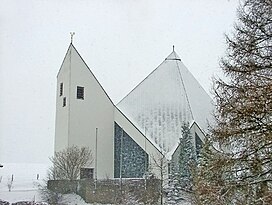
In 1696 Christian Floßbach had a chapel built in honor of St. Anne on a piece of land belonging to the Jostberg Kapellansgut. The chapel, which had become dilapidated at the end of the 19th century, was replaced by a new church in 1901. As early as 1965 this church was replaced by a modern church, as the old building no longer met the requirements of the time.
bus connections
Jostberg is connected to local public transport via the Hämmern stop on line 336 (VRS / OVAG).
Individual evidence
- ↑ River Area Geoinformation System (FluGGS). Wupperverband , accessed on December 21, 2017 .
- ↑ Topographical Information Management TIM-online, provided by the Cologne District Government
- ^ City of Wipperfürth, public announcement from June 2009; Allocation of the streets to the individual electoral districts
- ^ Historika25, Landesvermessungsamt NRW, sheet 4810, Wipperfürth
- ^ Peter Opladen: The Deanery Wipperfürth. Verlag F.Schmitt, Siegburg 1955.
- ↑ Fred Antweiler: Wipperfürth and his church villages. depicted in historical photos by Fred Antweiler and Frank Berger. Heider-Verlag, Bergisch Gladbach 1986, ISBN 3-87314-176-0 .
- ↑ Busnetz 2010, Oberbergischer Kreis, published by Verkehrsverbund Rhein-Sieg GmbH


