List of mountains of the Rhenish Slate Mountains
| |||||||||||||||||||||
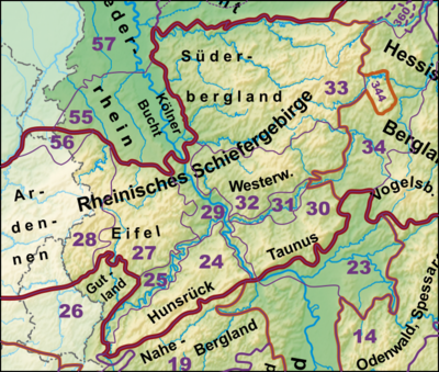
Rhenish slate mountains (with objects in neighboring landscapes) : - Highest elevations of partial mountain ranges and neighboring landscapes - some river / estuary heights - four largest reservoirs - important large cities; other selected cities Altitude information in meters (m) above mean sea level (NHN) |
The list of mountains of the Rhenish Slate Mountains shows a selection of mountains, elevations and their foothills of the sub- mountain ranges and landscapes that make up the Rhenish Slate Mountains - sorted according to natural spatial main unit groups and height in meters (m) above sea level.
-
See also these lists:
- Mountains in Hessen
- Mountains in North Rhine-Westphalia
- Mountains in Rhineland-Palatinate
- Mountains in Saarland
Explanations of the abbreviations used below can be found below .
Ardennes
The Ardennes are located in Belgium and with foothills in France and Luxembourg.
- Baraque de Fraiture (652 m), Province of Luxembourg (B)
- Cairn Roy Albert (589 m), Province of Luxembourg (B)
- Hochtumsknopf (Hüttensknipp; 510 m), Province of Liege (B)
- Croix Scaille (505 m), Province of Namur (B)
Eifel
The Eifel lies in Germany and with foothills in Belgium and Luxembourg.
- Hohe Acht (746.9 m), Hohe Eifel (RP)
- Ernstberg (699.8 m), Vulkaneifel (RP)
- nameless knoll (near Schwarzer Mann ; 699.1 m), Schnee-Eifel (RP)
- Schwarzer Mann (697.8 m), Schnee-Eifel (RP)
- Botrange (694.24 m), Hohes Venn (B)
- Weißer Stein (693 m), North Eifel (NW / B)
- Scharteberg (691.4 m), Vulkaneifel (RP)
- Nürburg (approx. 676.5 m), Hohe Eifel (RP)
- Hochkelberg (674.9 m), Hohe Eifel (RP)
- Raßberg (663.8 m), Hohe Eifel (RP)
- Steling (658.3 m), Hohes Venn (NW / B)
- Giescheid (652 m), North Eifel (NW)
- Nerother Kopf (651.7 m), Vulkaneifel (RP)
- Aremberg (623.8 m), Ahr Mountains (RP)
- Hardtkopf (601.5 m), South Eifel (RP)
- Michelsberg (586.1 m), Ahr Mountains (NW)
- Eigart (565.5 m), North Eifel (NW)
- Rockeskyller Kopf (554.6 m), Vulkaneifel (RP)
- Hoher List (549.1 m), Vulkaneifel (RP)
- Venison hill (525.3 m), Nordeifel / Rureifel (NW)
- Herkelstein (434.5 m), North Eifel (NW)
- Veitskopf (428.1), Vulkaneifel (RP)
- Burgberg (400.8), Rureifel, North Eifel (NW)
- Sonnenberg (393.3 m), Rureifel (NW)
- Calmont (378.4 m), Vordereifel (RP)
- Meuchelberg (372.9), Rureifel (NW)
- Bausenberg (339.8 m), North Eifel (RP)
- Landskrone (271.7 m), Ahr Mountains (RP)
High Fens
The High Fens is located in Belgium and with foothills in Germany.
- Botrange (694.24 m), Province of Liège (B)
- Pannensterzkopf ( Bovel ; approx. 662 m), Province of Liège (B)
- Hühnerhöhe (659.9 m), District Euskirchen (North Rhine-Westphalia)
- Steling (658.3 m), District of Aachen (North Rhine-Westphalia) / Province of Liège (B)
- Hahnheister (636.3 m), District of Aachen (North Rhine-Westphalia) / Province of Liège (B)
- Hohe Mark (approx. 609 m), Province of Liège (B)
Hunsrück

The Hunsrück lies in Rhineland-Palatinate and with foothills in the Saarland.
- Erbeskopf (816.32 m), Black Forest High Forest (RP)
- At the two stones (766.2 m), Idarwald
- Kahlheid (766.0 m), Idarwald (RP)
- Ruppelstein (762.7 m), Black Forest High Forest (RP)
- Sandkopf (757.4 m), Black Forest High Forest (RP)
- Steingerüttelkopf (756.6 m), Idarwald (RP)
- Idarkopf (745.7 m), Idarwald (RP)
- Usarkopf (725.4 m), Idarwald (RP)
- Rösterkopf (708.1 m), Osburger Hochwald (RP)
- Friedrichskopf (707.4 m), Black Forest High Forest (RP)
- Dollberg (695.4 m), Black Forest High Forest (RP, SL)
- Teufelskopf (695.0 m), Black Forest High Forest (RP)
- Schimmelkopf (694.8 m), Black Forest High Forest (RP, SL)
- Mückenbornberg (692.6), Black Forest High Forest (RP)
- Hohe Wurzel (668.9 m), Osburger Hochwald (RP)
- Haardtkopf (658.0 m), Haardtwald (RP)
- Ellerspring (656.8 m), Soonwald - origin of the Ellerbach (RP)
- Simmerkopf (653.0 m), Soonwald (RP)
- Ringkopf (650.1 m), Idarwald (RP)
- Hochsteinchen (648.3 m), Soonwald (RP)
- Schanzerkopf (643.5 m), Soonwald (RP)
- Kandrich (638.6 m), Binger Wald (RP)
- Wildburghöhe (633.5 m), Soonwald (RP)
- Alteburg (620.5 m), Soonwald (RP)
- Womrather Höhe (599.1 m), Lützelsoon (RP)
- Koppensteiner Höhe (554.9 m), Soonwald (RP)
Kellerwald
The Kellerwald is exclusively in Hesse.
- Desert garden (675.3 m), Waldeck-Frankenberg district, Schwalm-Eder district
- Hohes Lohr (656.7 m), Waldeck-Frankenberg district
- Große Aschkoppe (639.8 m), Waldeck-Frankenberg district
- Hunsrück (635.9 m), Schwalm-Eder district
- Traddelkopf (626.4 m), Waldeck-Frankenberg district
- Auenberg (610.7 m), Waldeck-Frankenberg district
- Jeust (approx. 585 m), Waldeck-Frankenberg district, Schwalm-Eder district
- Sauklippe (584.4 m), Schwalm-Eder district
- Valley passage (566.1 m), Waldeck-Frankenberg district
- Homberg (518.5 m), Waldeck-Frankenberg district
- Peterskopf (506.6 m), Waldeck-Frankenberg district
- Hundskopf (470.6 m), Schwalm-Eder district
- Rabenstein (439.3 m), Waldeck-Frankenberg district
- Keseberg (431.2 m), Waldeck-Frankenberg district
- Uhrenkopf (approx. 405 m), Waldeck-Frankenberg district
Süderbergland
The Southern Mountains include u. a. the historical regions of Sauerland , Upland , Siegerland , Wittgensteiner Land , Bergisches Land and parts of the Hessian hinterland .
Rothaar Mountains
For once, the deeper subdivision of the Rothaargebirge is largely based on historical regions. It is located in North Rhine-Westphalia and with foothills in Hesse.
Sauerland and Upland


Of the following mountains at the center of heights of the Rothaargebirge, precisely those are included in the historical upland that are located in the Hessian district of Waldeck-Frankenberg.
- Langenberg (843.2 m), Hochsauerlandkreis (NW), Waldeck-Frankenberg (HE)
- Hegekopf (842.9 m), Waldeck-Frankenberg district (HE)
- Kahler Asten (841.9 m), Hochsauerlandkreis, Rothaargebirge (NW)
- Ettelsberg (837.7 m), Waldeck-Frankenberg district (HE)
- Clemensberg (837 m), Hochsauerlandkreis (NW)
- Hopperkopf (832.3 m), Hochsauerlandkreis, Waldeck-Frankenberg district (NW, HE)
- Mühlenkopf (approx. 815 m), Waldeck-Frankenberg district (HE)
- Hunau (818.5 m), Hochsauerlandkreis (NW)
- Ziegenhelle (815.9 m), Hochsauerlandkreis (NW)
- Wallershöhe (812.1 m), Hochsauerlandkreis (NW)
- Bremberg (approx. 810 m), Hochsauerlandkreis (NW)
- Hoher Eimberg (806.1 m), Hochsauerlandkreis, Waldeck-Frankenberg district (NW, HE)
- Hoppernkopf (805.0 m), Hochsauerlandkreis, Waldeck-Frankenberg district (NW, HE)
- Hillekopf (804.9 m), Hochsauerlandkreis (NW)
- Mittelberg (801.0 m), Waldeck-Frankenberg district (HE)
- Reetsberg (792.2 m), Hochsauerlandkreis (NW)
- Schlossberg (791.3 m), Hochsauerlandkreis (NW)
- Bollerberg (757.7 m), Hochsauerlandkreis (NW)
- Härdler (756.3 m), Olpe district (NW)
Wittgensteiner Land
The Wittgensteiner Land is located exclusively in North Rhine-Westphalia.
- Albrechtsberg (768 m), Siegen-Wittgenstein district
- Hohe Hessel (742.8 m), Siegen-Wittgenstein district
- Großer Kopf (740 m), Siegen-Wittgenstein district
- Compass (694.1 m), Siegen-Wittgenstein district
- Ebschloh (686.3 m), Siegen-Wittgenstein district
Siegerland (historical)
The historic Siegerland (not to be confused with the Siegerland natural area ) is located exclusively in North Rhine-Westphalia:
- Riemen (677.7 m), Siegen-Wittgenstein district
- Aukopf (644.9 m), Siegen-Wittgenstein district
- Pfaffenhain (658.5 m), Siegen-Wittgenstein district
- Kindelsberg (618.1 m), Siegen-Wittgenstein district
Hessian hinterland
The Hessian hinterland is exclusively in Hesse.
- Bagpipe (673.5 m), counties Marburg-Biedenkopf and Waldeck-Frankenberg (HE)
- Rimberg (495.1 m), Marburg-Biedenkopf district
South Sauerland highlands
Saalhaus mountains
The Saalhauser Berge are exclusively in North Rhine-Westphalia.
- Himberg (688.5 m), Hochsauerlandkreis (NW)
- Hoher Lehnberg (668.8 m), Olpe district (NW)
- Jürgensberg ( 619.2 m ), Olpe district (NW)
- Beerenberg (614.1 m), Hochsauerlandkreis (NW)
Ebbe Mountains
The Ebbegebirge is exclusively in North Rhine-Westphalia.
- Nordhelle (663.3 m), Märkischer Kreis
- Waldberg (approx. 638 m), Märkischer Kreis
- Homert (538.3 m), Märkischer Kreis
Lennegebirge
The Lennegebirge lies exclusively in North Rhine-Westphalia.
- Homert (656.1 m), Hochsauerlandkreis
- Schomberg (647.6 m), Hochsauerlandkreis
- Large piece of sun (686.8 m), Hochsauerlandkreis
- Dümberg (575.5 m), Hochsauerlandkreis
Middle-big mountainous region
- Rammskopf (523.1 m), Märkischer Kreis
- Homert (519 m), Oberbergischer Kreis
- Horst (514.9 m), Märkischer Kreis
- Eulenberg (497.1 m), Märkischer Kreis
- Sonnenberg (458.5 m), Olpe district
- Nordhelle (437.2), Märkischer Kreis
- Bracht (429.1 m), Olpe district
- Rappelsberg (410.7 m), Olpe district
- Gilberg (360.0 m), Olpe district
Siegerland (natural area)
The Siegerland natural area (not to be confused with the historic Siegerland ) is located exclusively in North Rhine-Westphalia:
- Old Castle (633.0 m), Siegen-Wittgenstein district, (NW)
- Lipper Nürr (616.9 m), Altenkirchen district (RP), Siegen-Wittgenstein district (NW)
- Sanktkopf (approx. 606 m), Siegen-Wittgenstein district, (NW)
- Die Höh (approx. 598 m), Siegen-Wittgenstein district (NW)
- The castle (594.5 m), Siegen-Wittgenstein district (NW)
- Hohenseelbachskopf (517.5 m), Siegen-Wittgenstein district (NW), Altenkirchen district (RP)
- Eisernhardt (482.3 m), urban area Siegen (NW)
North Sauerland Oberland
Arnsberg Forest
The Arnsberg Forest is located in the nature park of the same name exclusively in North Rhine-Westphalia.
- Plackweghöhe (actually: nameless summit; 581.5), Hochsauerlandkreis
- Second highest mountain: nameless knoll (559.5), Hochsauerlandkreis
- Third highest mountain: nameless knoll (557.4), Hochsauerlandkreis
- Warsteiner Kopf (556.9 m), Hochsauerlandkreis
- Gemeinheitskopf (551.9 m), Hochsauerlandkreis
- Niekopf (550.4 m), Soest district
Bergisches Land on the Upper Agger and Wiehl
- Unnenberg (505.7 m), Oberbergischer Kreis
Taunus
The Taunus lies in Hesse and with foothills in Rhineland-Palatinate.
- Großer Feldberg (881.5 m), Hochtaunuskreis
- Kleiner Feldberg (825.2 m), Hochtaunuskreis
- Altkönig (798.2 m), Hochtaunuskreis
- Weilsberg (700.7 m), Hochtaunuskreis
- Glaskopf (686.8 m), Hochtaunuskreis
- Horse head (662.6 m), Hochtaunuskreis
- Cold hostel (619.3 m), Rheingau-Taunus district
- Hohe Wurzel (617.9 m), Rheingau-Taunus-Kreis
- Hohe Kanzel (591.8 m), Rheingau-Taunus-Kreis
- Herzberg (591.4 m), Hochtaunuskreis
- Hallgarter Zange (580.5 m), Rheingau-Taunus-Kreis
- Erbacher Kopf (579.8 m), Rheingau-Taunus district
- Wolfsküppel (545.1 m), Hochtaunuskreis
- Rattle (539.4 m), Wiesbaden
- Cow bed (525.6 m), Limburg-Weilburg district
- Steinkopf (518.0 m), Wetteraukreis
- Rossert (515.9 m), Main-Taunus-Kreis
- Atzelberg (506.7 m), Main-Taunus-Kreis
- Großer Lindenkopf (498.7 m), Rheingau-Taunus district
- Buchwaldskopf (approx. 492 m), Rheingau-Taunus district
- Gold mine (492.0 m), Hochtaunuskreis
- Kellerskopf (474.0 m), Wiesbaden
- Suterkopf (461.8 m), Limburg-Weilburg district
- Staufen (451.0 m), Main-Taunus-Kreis
- Chicken trumpet (369.3 m), Limburg-Weilburg district
Westerwald (natural area)
Westerwald
The Westerwald lies in Rhineland-Palatinate and with foothills in North Rhine-Westphalia and Hesse.
- Fuchskaute (657.3 m), Westerwaldkreis (RP)
- Stegskopf (654.4 m), Altenkirchen district (RP)
- Salzburger Kopf (654.2 m), Westerwaldkreis (RP)
- Höllberg (642.8 m), Lahn-Dill district (HE)
- On the Baar (> 621.25 m), Lahn-Dill-Kreis (HE)
- Bartenstein ( Barstein ; approx. 614 m), Lahn-Dill-Kreis (HE)
- Knot (605.4 m), Lahn-Dill-Kreis (HE)
- Alarm pole (545.2 m), Westerwaldkreis (RP)
- Köppel (540.2 m), Westerwaldkreis (RP)
- Hohenseelbachskopf (517.5 m), Siegen-Wittgenstein district (NW), Altenkirchen district (RP)
- Gräbersberg (513.1 m), Westerwaldkreis (RP)
- Mahlscheid (509.3 m), Siegen-Wittgenstein district (NW) and Altenkirchen district (RP)
- Helleberg (491.3 m), Westerwaldkreis (RP)
- Asberg (430.2 m), Neuwied district (RP)
- Meerberg ( Mehrberg ; 429.1 m), Neuwied district (RP)
- Malberg (422.0 m), Westerwaldkreis (RP)
- Hummelsberg (407.4 m), Neuwied district (RP)
- Minderberg (approx. 405 m), Neuwied district (RP)
- Heidenhäuschen (397.9 m), Limburg-Weilburg district (HE)
- High damage (388.3 m), Rhein-Sieg-Kreis (RP)
- Beulskopf (388.2 m), Altenkirchen district (RP)
- Himmerich (367.1 m), Rhein-Sieg district (NW)
- Leyberg (359.2 m), Rhein-Sieg-Kreis (NW)
- Pfahlberg ( Pfahlberg ; 346.2 m), Westerwaldkreis (RP)
- Beselicher Kopf (296.0 m), Limburg-Weilburg district (HE)
Gladenbacher Bergland
The Gladenbacher Bergland lies exclusively in Hesse.
- Angelburg (609.4 m), Lahn-Dill district
- Eschenburg (589.0 m), Lahn-Dill district
- Schwarzenberg (561.2 m), Marburg-Biedenkopf district
- Daubhaus (551.8 m), Marburg-Biedenkopf district
- Hünstein (503.7 m), Marburg-Biedenkopf district
- Dünsberg (497.7 m), district of Giessen
- Hornberg (451.0 m), Marburg-Biedenkopf district
- Altenberg (442.2 m), Lahn-Dill district
- Volpertsberg (426.4 m), Lahn-Dill district
Struth
- Hemmrain (561 m), Lahn-Dill district
Abbreviations
The abbreviations in the table mean:
German states (federal states; ISO 3166-2 ):
- HE = Hessen
- NW = North Rhine-Westphalia
- RP = Rhineland-Palatinate
- SL = Saarland
States ( license plate ):
- B = Belgium
- D = Germany (generally not mentioned above)
- F = France (not mentioned above because no mountain is listed yet)
- L = Luxembourg (not mentioned above because no mountain is listed yet)


