
District of Dahme-Spreewald
| coat of arms | Germany map |
|---|---|

|

Coordinates: 51 ° 57 ' N , 13 ° 54' E |
| Basic data | |
| State : | Brandenburg |
| Administrative headquarters : | Luebben (Spreewald) |
| Area : | 2,274.48 km 2 |
| Residents: | 170,791 (Dec. 31, 2019) |
| Population density : | 75 inhabitants per km 2 |
| License plate : | LDS, KW, LC, LN |
| Circle key : | 12 0 61 |
| NUTS : | DE424 |
| Circle structure: | 37 municipalities |
| Address of the district administration: |
Reutergasse 12 15907 Lübben (Spreewald) |
| Website : | |
| District Administrator : | Stephan Loge ( SPD ) |
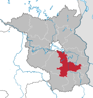
| Location of the Dahme-Spreewald district in Brandenburg | |
  |
|
The district of Dahme-Spreewald ( Lower Sorbian Wokrejs Damna-Błota ) is a district in the southeast of Brandenburg .
geography
The district of Dahme-Spreewald includes
- the Dahme lake area with the Dahme-Heideseen nature park ,
- the Niederlausitz with the nature park Niederlausitzer Landücken and
- the Spreewald with the Spreewald biosphere reserve .
With the municipality of Steinreich , a small part of the Fläming is also located in the district.
Neighboring areas are the Oder-Spree district in the east, the Spree-Neiße , Oberspreewald-Lausitz and Elbe-Elster districts in the south and the Teltow-Fläming district in the west . In the north, following the principle of the formation of sectoral districts around the state of Berlin in the course of the district reform , the district borders on the federal capital. The area of the district is 42.2% forested and 35.6% consists of agricultural land.
Communities
After the municipal reform of 2003 , the district comprises 37 municipalities, including nine cities. According to the official statement in 2016, nine municipalities are officially bilingual ( German , Lower Sorbian ).
(Residents on December 31, 2019)
|
Unofficial cities
Other municipalities not subject to official duties
|
  |
Offices and associated municipalities
(seat of the official administration *)
|
1. Lieberose / Oberspreewald
2. Schenkenländchen (8766)
|
3. Unterspreewald (8945)
|
On January 1, 2013, the Golßener Land and Unterspreewald offices merged to form the new Unterspreewald office .
history
The district of Dahme-Spreewald was created on December 6, 1993 in the course of the municipal reorganization of the state of Brandenburg from the districts of Königs Wusterhausen and Lübben and the district of Luckau without the city and the Dahme / Mark office . In addition, the Telz community came from the Zossen district , the Wernsdorf community from the Fürstenwalde district and the Lieberose office and the Plattkow community from the Beeskow district came to the Dahme-Spreewald district.
Population development
|
|
|
Territory and number of inhabitants on December 31 of the respective year, from 2011 based on the 2011 census
politics
District council
Since the election on May 26, 2019, the 56 seats in the district council have been distributed among parties and groups of voters as follows:
| Party / group | Voices 2014 | Voices 2019 | Seats 2014 | Seats 2019 | |
|---|---|---|---|---|---|
| SPD | 26.9% | 20.2% | 15th | 11 | |
| AfD | 6.8% | 17.1% | 4th | 10 | |
| CDU | 22.2% | 15.2% | 12 | 9 | |
| THE LEFT | 18.3% | 12.5% | 10 | 7th | |
| GREEN / B90 | 5.6% | 11.1% | 3 | 6th | |
| FDP | 4.4% | 5.3% | 3 | 3 | |
| Free group of voters farmers | 5.1% | 5.2% | 3 | 3 | |
| Independent Citizens List (UBL) | 4.9% | 4.6% | 3 | 3 | |
| BVB / FREE VOTERS | - | 3.5% | - | 2 | |
| FWKW * | - | 2.4% | - | 1 | |
| We for KW (WFKW) | 2.0% | 1.8% | 1 | 1 | |
| NPD | 3.4% | - | 2 | - |
* Free independent voter community in Königs Wusterhausen
District Administrator
- 1993–1997: Hartmut Linke (SPD)
- 1997-2008: Martin Wille (SPD)
- since March 1, 2008: Stephan Loge (SPD)
Loge achieved 52.6% of the valid votes in the district election on October 11, 2015 and was thus confirmed in his office for another eight years in accordance with Section 126 of the municipal constitution of the State of Brandenburg.
coat of arms
The coat of arms was approved on November 16, 1995.
Blazon : “In silver a curved blue tip covered with a golden royal crown; accompanied in front by a resisting gold-armored, cut-off red bull's trunk, behind by a gold-armored, cut-off red eagle's body. "
The coats of arms of the offices, cities and municipalities of the district are in a separate list .
Economy and Infrastructure
economy
In the Future Atlas 2016 , the district of Dahme-Spreewald was ranked 246 out of 402 districts, municipal associations and independent cities in Germany, making it one of the regions with a “balanced risk-opportunity mix”. In the 2019 edition, it improved to 200th place from 401st. In 2020, the district made it into the top ten in Germany in the regional ranking of the Institute of German Economy .
The economic structure is roughly divided into the two areas of the north and south district. While the northern district is mainly characterized by Berlin-Schönefeld Airport (from October 2020 Berlin-Brandenburg BER ) and industrial, the southern part of the district has a pronounced agricultural and tourist economic structure. With the area "Schönefelder Kreuz", which includes the communities Schönefeld, Königs Wusterhausen and Wildau, the district also has one of 15 specially funded regional growth centers in the state of Brandenburg.
There are five key industry locations in the state of Brandenburg, in which certain areas of industry expertise are concentrated:
| Industry focus | Communities | Industry areas of expertise |
|---|---|---|
| Schönefeld and the surrounding area |
Schönefeld , Eichwalde , Schulzendorf , Zeuthen and Blankenfelde-Mahlow in the Teltow-Fläming district |
Automotive |
| Biotechnology / Life Science | ||
| logistics | ||
| Aeronautical engineering | ||
| Media / KT | ||
| metal | ||
| Wildau | ||
| Wildau | Automotive | |
| Biotechnology / Life Science | ||
| logistics | ||
| Aeronautical engineering | ||
| Media / KT | ||
| metal | ||
| King Wusterhausen | ||
| King Wusterhausen | Automotive | |
| Biotechnology / Life Science | ||
| logistics | ||
| Aeronautical engineering | ||
| Media / KT | ||
| metal | ||
| Mittenwalde | ||
| Mittenwalde | Automotive | |
| logistics | ||
| Aeronautical engineering | ||
| Rail transport | ||
| metal | ||
| Golßen | Golßen | Food industry |
| Luebben (Spreewald) | Luebben (Spreewald) | Food industry |
traffic
The following traffic routes run through the district:
- Federal motorways: A 10 , A 12 , A 13 , A 113 , A 117
- Federal highways : B 87 , B 96 , B96a, B 102 , B 115 , B 179 , B 246 , B 320
- Waterways: Königs Wusterhausen harbor , the Dahme and Spree rivers and the Notte Canal
- Airport: Schönefeld
- Railway line Berlin – Görlitz and railway line Berlin – Dresden
Protected areas
There are 77 designated nature reserves in the district (as of February 2017).
License Plate
On January 1, 1994, the district was assigned the distinctive sign LDS and has been issued ever since. Since July 2, 2015, the differentiating signs KW (Königs Wusterhausen), LC (Luckau) and LN (Lübben) have been available again due to the license plate liberalization .
Until about the year 2000 vehicles from the old districts received special identification numbers:
| area | Letters | numbers |
|---|---|---|
| Old district of Königs Wusterhausen | A to K | 1 to 999 |
| P to S | ||
| X to Z | ||
| AA to KY | 1 to 99 | |
| PA to SZ | ||
| XA to ZZ | ||
| AA to AZ | 100 to 999 | |
| Old district of Luckau | L to N | 1 to 999 |
| LA to NZ | 1 to 99 | |
| Altkreis Lübben | T to V | 1 to 999 |
| TA to VZ | 1 to 99 |
The allocation of identification numbers for the old district of Luckau only existed for a few years. The vehicles were then registered in Lübben.
Incorporation and amalgamation of municipalities
The table shows the incorporations and mergers of municipalities since the district was formed on December 5, 1993.
| local community | date | Inclusion of | to | Merger of | to |
|---|---|---|---|---|---|
| Alt Zauche-Wußwerk | 10/26/2003 |
Alt Zauche Wußwerk |
Alt Zauche-Wußwerk | ||
| Bursting land | 02/01/2002 |
Freiwalde Niewitz Reichwalde |
Bursting land | ||
| Bestensee | 10/26/2003 | Pätz | Bestensee | ||
| Byhleguhre-Byhlen | 10/26/2003 |
Byhleguhre Byhlen |
Byhleguhre-Byhlen | ||
| Drahnsdorf | December 31, 2002 | Drahnsdorf Falkenhain |
Drahnsdorf | ||
| Golßen | 05/01/1998 | Mahlsdorf | Golßen | ||
| Golßen | December 31, 2002 | Use | Golßen | ||
| Great Koris | 10/26/2003 | Soldering | Great Koris | ||
| half | 10/26/2003 |
Briesen Freidorf Oderin |
half | ||
| Heidesee | 10/26/2003 |
Dolgenbrodt Gräbendorf Gussow Streganz Wolzig |
Heidesee |
Bindow Blossin Dannenreich Friedersdorf Kolberg Prieros |
Heidesee |
| Heath view | December 31, 1997 |
Bornsdorf Weißack |
Burst source | ||
| Heath view | December 31, 1997 |
Gehren Langengrassau Waltersdorf desert stamp |
Heath view | ||
| Heath view | December 31, 2001 |
Beesdau Berstequell Falkenberg Goßmar Heideblick Pitschen-Pickel |
Heath view | ||
| Heath view | 10/26/2003 | Walddrehna | Heath view | ||
| Jamlitz | 10/26/2003 |
Leeskow Ullersdorf |
Jamlitz | ||
| Kasel-Golzig | December 31, 2002 |
Jetsch Schiebsdorf |
Kasel-Golzig | ||
| King Wusterhausen | 10/26/2003 |
Kablow Niederlehme Senzig Wernsdorf Zeesen Zernsdorf |
King Wusterhausen | ||
| King Wusterhausen | 02/29/2004 |
Diepensee devastation |
King Wusterhausen | ||
| Krausnick-Groß Wasserburg | December 31, 2001 |
Krausnick Groß Wasserburg |
Krausnick-Groß Wasserburg | ||
| Love rose | 01/01/1995 | Goschen | Love rose | ||
| Love rose | 06/01/1997 | Trebitz | Love rose | ||
| Love rose | 12/29/1997 | Blasdorf | Love rose | ||
| Love rose | 10/26/2003 | Doberburg | Love rose | ||
| Luebben (Spreewald) | December 6, 1993 |
Hartmannsdorf Lubolz Radensdorf |
Luebben | ||
| Luckau | 11/30/1997 | Giessmannsdorf | Luckau | ||
| Luckau | 09/01/1998 | Zieckau | Luckau | ||
| Luckau | December 31, 1998 | Mountains | Luckau | ||
| Luckau | December 31, 1999 |
Egsdorf Princely Drehna Karche-Zaacko Kreblitz Kümmritz Willmersdorf-Stöbritz |
Luckau | ||
| Luckau | December 31, 2000 | Freesdorf | Luckau | ||
| Luckau | December 31, 2001 |
Terpt Zöllmersdorf |
Luckau | ||
| Luckau | 06/01/2002 | Uckro | Luckau | ||
| Luckau | December 6, 1993 |
Cahnsdorf Duben Görlsdorf Schlabendorf am See |
Luckau | ||
| Märkische Heide | 10/26/2003 |
Alt-Schadow Dollgen Dürrenhofe Gröditsch Groß Leine Hohenbrück - New Schadow Krugau Kuschkow Pretschen |
Biebersdorf Glietz Groß Leuthen Klein Leine Leibchel Plattkow Schuhlen - Wiese Wittmannsdorf - Bückchen |
Märkische Heide | |
| Mittenwalde | 10/26/2003 |
Brusendorf Gallun Motzen Ragow Schenkendorf Telz Töpchin |
Mittenwalde | ||
| New grow | 10/26/2003 |
Briesensee Caminchen |
New grow | ||
| Rietzneuendorf-Staakow | 10/26/2003 |
Rietzneuendorf - Friedrichshof Staakow |
Rietzneuendorf-Staakow | ||
| Schönefeld | 09/27/1998 |
Rotberg Waltersdorf |
Waltersdorf | ||
| Schönefeld | 10/26/2003 |
Großziethen Kiekebusch Schönefeld Selchow Waltersdorf Waßmannsdorf |
Schönefeld | ||
| Schönwald | December 31, 2001 |
Schönwalde Waldow / Brand |
Schönwald | ||
| Schwielochsee | 06/01/1997 | Goyatz- Guhlen Siegadel |
Goyatz | ||
| Schwielochsee | 10/26/2003 | Goyatz Jessern Lamsfeld - Groß Liebitz Mochow Ressen - Zaue Speichrow |
Schwielochsee | ||
| Spreewaldheide | 10/26/2003 |
Butzen Laasow Sacrow-Waldow |
Spreewaldheide | ||
| Realm of stone | December 31, 2002 |
Glienig Sellendorf |
Realm of stone | ||
| Unterspreewald | December 31, 2001 |
Leibsch Neu Lübbenau Neuendorf am See |
Unterspreewald |
Others
On September 23, 2008, the district was awarded the title Place of Diversity by the federal government .
Since 2019, the district in the municipality of Halbe has been home to the largest Esperanto center in the world, the Esperanto train station.
Web links
Individual evidence
- ↑ Population in the State of Brandenburg according to municipalities, offices and municipalities not subject to official registration on December 31, 2019 (XLSX file; 223 KB) (updated official population figures) ( help on this ).
- ↑ MWFK: Eight other communities belong to the Sorbian settlement area ( page no longer available , search in web archives ) , accessed on December 7, 2016.
- ↑ Population in the State of Brandenburg according to municipalities, offices and municipalities not subject to official registration on December 31, 2019 (XLSX file; 223 KB) (updated official population figures) ( help on this ).
- ↑ Law on the reorganization of the districts and independent cities in the state of Brandenburg (KNGBbg). Retrieved June 12, 2020 .
- ^ Historical municipality register of the state of Brandenburg 1875 to 2005. Dahme-Spreewald district . Pp. 8-9
- ↑ Population in the state of Brandenburg from 1991 to 2015 according to independent cities, districts and municipalities , Table 7
- ^ Office for Statistics Berlin-Brandenburg (Ed.): Statistical report AI 1, A II 4. Population development and population status in the state of Brandenburg. (respective editions of the 4th quarter)
- ↑ Local elections in the state of Brandenburg on May 26, 2019 , p. 15
- ^ Result of the district election on October 11, 2015 ( Memento from July 4, 2016 in the Internet Archive )
- ↑ Coat of arms information on the service portal of the state administration of Brandenburg
- ↑ Future Atlas 2016. Archived from the original on October 2, 2017 ; accessed on March 23, 2018 .
- ↑ PROGNOS future atlas. Handelsblatt, accessed on December 10, 2019 .
- ↑ Regional ranking : Dahme-Spreewald at the top. In: Märkische Allgemeine . June 4, 2020, accessed June 12, 2020 .
- ^ Historical municipality register of the state of Brandenburg 1875 to 2005. Dahme-Spreewald district . Pp. 38-42.
- ↑ Esperanto Center: The first guests have arrived. Retrieved July 28, 2019 .

Counties: Barnim | Dahme-Spreewald | Elbe Elster | Havelland | Märkisch-Oderland | Oberhavel | Oberspreewald-Lausitz | Oder-Spree | Ostprignitz-Ruppin | Potsdam-Mittelmark | Prignitz | Spree-Neisse | Teltow-Fläming | Uckermark
Independent cities: Brandenburg an der Havel | Cottbus | Frankfurt (Oder) | Potsdam