
Lueneburg Heath
| Lueneburg Heath | |||
|---|---|---|---|
| Systematics according to | Handbook of the natural spatial structure of Germany | ||
| Greater region 1st order | North German Lowlands | ||
| Greater region 3rd order | 64 → Lüneburg Heath |
||
| Geographical location | |||
| Coordinates | 53 ° 10 '7 " N , 9 ° 56' 22.9" E | ||
|
|||
| state | Lower Saxony | ||
| Country | Germany | ||

The Lüneburger Heide ( Low German Lümbörger Heid ) is a large, geographically predominantly flat , undulating heather , geest and forest landscape in northeast Lower Saxony in the catchment areas of the cities of Hamburg , Bremen and Hanover . It is named after the city of Lüneburg and comprises the main part of the former principality of Lüneburg .
Large areas of heathland have been preserved, especially in the central parts of the Lüneburg Heath . They covered large parts of northern Germany until the beginning of the 19th century, but have now almost completely disappeared outside of the Lüneburg Heath. The heathland has been created since the Neolithic Age by overgrazing the formerly widespread forests on barren sandy soils in the Geest area. The remnants of this historical cultural landscape that still exist are kept open primarily through grazing with heather sheep . With regard to its landscape form, the Lüneburg Heath is important for tourism in Northern Germany . It is partly maintained in nature parks .


geography
Location and structure
The Lüneburg Heath lies between the Elbe in the northeast and the Aller in the southwest, to whose broad, glacial valleys , the heath slopes significantly. In the west, the Lüneburg Heath merges with the Stader Geest, interspersed with lowlands, and in the east with the Altmark with the Lüchower Niederung ( Wendland ). Biogeographically , the Lüneburg Heath belongs to the easternmost edge of the Atlantic region .
Geomorphologically the parallelogram-shaped area is divided by ridges which roughly the shape of an N describe. The main ridge of the Hohe Heide runs diagonally from the steep Harburg Mountains (up to 155 m above sea level ) in the northwest, immediately south of Hamburg , over the high area around the Wilseder Berg ( 169 m ; with the headwaters of 4 major heather rivers) to the Lüßmoränen im Southeast and its peninsula-like eastern foothills Wierener Berge (up to 136 m ). In the Ostheide in the east, the crested Göhrde- Drawehn mountain range (up to 142 m ) , which strikes north-south, forms a noticeable border to the lowlands of the Jeetzel in the Altmark. To the north, to the valley of the Elbe, the Ostheide falls comparatively steeply.
Between the northern parts of Hoch- and Ostheide, on the lower reaches of Luhe and Ilmenau , lies the Luheheide , which is less high overall and more agitated in relief , and Lüneburg to the east ; the smaller Bevens Basin near Bad Bevensen and the larger Uelzen Basin near Uelzen connect to the southeast .
In the southwest, the island-like Falkenberg terminal moraine ( 150 m ) branches off from the Hohe Heide and is by far the highest elevation in the southern heath . In the southern part, the Lüneburg Heath borders on the Lintelner Geest to the west , and the eastern part of the Achim- Verden Geest . Here there are narrow valleys, which are also the characteristic feature of the neighboring Fallingbosteler Heidmark in the western Südheide.
The geographical designation Lüneburg Heath has grown historically and largely coincides with the territory of the Principality of Lüneburg, but nevertheless also refers to an area that can be defined according to geographical spatial criteria. It is characterized as a natural area with a specific combination of abiotic factors (climate, relief, water balance, soil, geological structure) and biotic factors ( flora and fauna ), on the other hand as a cultural and economic area that is based on it and, in turn, shapes it.
Natural structure
In terms of natural space , the Lüneburg Heath represents a major region of the 3rd order and main unit group (two-digit) within the North German lowlands (major region of the 1st order). It is divided into main units (4th order regions; three digits) and 5th order regions (one decimal place) as follows ; Sources see each with the main units) on:
-
64 Lüneburg Heath (6972 km²)
- 640 Hohe Heide (1286 km²)
- 640.0 Wilseder terminal moraines (7 subunits; 804 km²)
- 640.1 Sprakensehler terminal moraines (3 subunits; 482 km²)
- 641 Südheide (2678 km²)
- 641.0 Walsroder loam geest (5 subunits; 652 km²)
- 641.1 Hermannsburg Sandgeest (10 subunits: 1060 km²)
- 641.2 Steinhorster sand and loam area (7 sub-units; 645 km²)
- 641.3 Südheidemoore (3 subunits; together with 641.4: 321 km²)
- 641.4 Gose-Ise sand plain (together with 641.4: 321 km²)
- 642 Ostheide (1639 km²)
- 642.0 Jembke-Vorsfelder sand plates (2 sub-units)
- 642.1 Ehraer Moorniederung
- 642.2 Knesebeck-Bromer moraine plate (2 subunits)
- 642.3 Wittingen Flottsandgebiet
- 642.4 Ohretal
- 642.5 East Hanoverian gravel moraine (5 subunits and one singularity)
- 642.6 Lower Geest
- 642.7 Bohndorf terminal moraines
- 642.8 Neetzer Basin
- 642.9 Dahlenburg Basin
- 643 Uelzen and Bevens basins (716 km²)
- 643.0 Uelzen basin
- 643.1 Emmendorfer moraines
- 643.2 Bevens Basin
- 644 Luheheide (653 km²)
- 644.0 Harburg hill country
- 644.1 Seeveniederung
- 644.2 Toppenstedter Geest
- 644.3 Luheniederung
- 644.4 Mountains that miss the roof
- 644.5 Wetzer Mountains
- 644.6 Lueneburg Basin
- 644.7 Grünhagener terminal moraines
- 640 Hohe Heide (1286 km²)
Units 643 and 644 are also grouped under Nordheide ; According to this interpretation, the Lüneburg Heath would consist of only four main units.
Many of the drawn landscape boundaries cannot be defined in lines - for example the western boundary of the Hochheide, where the terminal moraines gradually merge into plateaus and sand. Therefore the main unit boundaries of the refining single sheets Hamburg-Süd (1964), Lüneburg (1980), Celle (1959) and Salzwedel (1970) as well as, on the south-east edge, Braunschweig (1962) differ considerably from those of the handbook of the natural spatial structure of Germany ( 7. Delivery 1961, card from 1960) from the same company. The north of the Hochheide with the Harburg mountains appears significantly smaller than the manual. This appears on the Hamburg-Süd sheet as a narrow strip that only includes the wooded terminal moraine, while in the manual the western (now eastern wing of the Apenser Lehmgeest, Zevener Geest , main unit group Stader Geest ) and eastern roofing (now Harburger Hügelland, Luheheide) the neighboring ones Main units was assigned.
Since the Federal Agency for Nature Conservation (BfN) also follows the boundaries of the individual sheets or has even measured them, the area information in the manual - 7539.0 km² for the total heath, 2090.2 km² for the main unit 640, 2165.4 km² for 641, 2049.8 km² for 642, 518.0 km² for 643 and 715.6 km² for 644 - are considered obsolete.
The different, sometimes misleading names of the BfN landscape profiles should be treated with caution. Occasionally two units are combined under the name of one of the two, or only part of it is carried under the name of a main unit.
Unit 640.1 leads BfN under "Lüß", which is initially the name of the forest around Unterlüß . However, this is not limited to the terminal moraine, and so the name appears both as Lüßmoränen (640.10) and Lüß plateau (640.11) in the Hochheide and, on its western roof, as Lüßplateau (641.19) in the Südheide. This reaches at least 118 m above sea level on the Haußelberg . NHN and also significantly exceeds its western and southern neighboring landscapes, but differs significantly from the terminal moraines in terms of soils and vegetation.
High heather
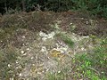
- The Hohe Heide consists of a series of terminal moraines from the inland ice of the Saale Ice Age (230,000–130,000 years ago) with the Wilseder Berg as its center. The mean altitude and relief energy are greater here than in the other natural spatial units of the Lüneburg Heath. Characteristic are dry hilltops, periglacial arid valleys and depressions such as the Totengrund . Here in particular there are still heather landscapes. Most of them are located in the Lüneburg Heath nature reserve and are of great tourist importance. However, there are also extensive pine forests.
Südheide
- In the southern heath , extensive, wavy to gently hilly sand areas , ground moraine plates and terminal moraine remnants from older ice ages dominate . Only the Falkenberg terminal moraine has a relief energy that in parts even exceeds that of the Hohe Heide. Large heather areas are still available on the military training areas near Bad Fallingbostel and Munster , but they are closed to tourism . But the Osterheide near Schneverdingen in the Lüneburg Heath NSG is also part of this natural spatial unit. On the heights between Schneverdingen and Walsrode there are larger moors such as the Pietzmoor and the Grundlose Moor . A large part of the southern heath is now covered by pine forests.
Ostheide
- The Ostheide , traversed by numerous terminal moraines, extends on the eastern edge of the Lüneburg Heath from Lüneburg to north of Wolfsburg. Some of the soil in this region is used intensively for agriculture. The northern parts, the so-called Göhrde and the heavily knolled Drawehn , on the other hand, as well as the southern terminal moraine ranges , are largely forested.
Uelzen and Bevens basins
- The basic moraine landscape of the Uelzen basin is mainly used for agriculture. There are also some pine forests on the surrounding mountain ranges. There are extensive heather areas here, for example, in the Ellerndorfer Heide in the western Uelzen district or the Klein Bünstorfer Heide .
Luheheide
- The terminal moraine lines of the Luheheide drop off with a clear edge to the Elbe valley. It is severely cut by the rivers such as Seeve , Aue and Luhe, all of which drain north to the Elbe . The mountain ridges in between are forested and hardly populated. Settlements crowd together in the valleys. There is hardly any heathland in this sub-area, they were mostly reforested with pine trees .
Administrative structure
The area of the Lüneburg Heath extends over the districts of Celle , Gifhorn , Heidekreis , Uelzen , Lüneburg , Lüchow-Dannenberg and the southeast part of the district of Harburg . It thus covers the main part of the administrative district of Lüneburg within its boundaries until 1978.
The district of Rotenburg (Wümme) belongs historically to the former administrative district of Stade , naturally to the Stader Geest and is therefore more part of the Elbe-Weser triangle . The Kettenburg , which today belongs to Visselhövede, was part of the Principality of Lüneburg , just like the municipality of Lauenbrück . In addition, foothills of the Lüneburg Heath natural area also extend to the southeast of the Rotenburg district. For reasons of regional marketing, several places in the Rotenburg district are trying to establish a relationship to the Lüneburg Heath, which is known throughout Germany.
Mountains and hills
The Lüneburg Heath generally has a flat wavy relief. The relief, however, is very uneven and includes broad ridges such as the Wilseder Berg ( 169.2 m, the highest elevation in the Lüneburg Heath), steep cones such as the Falkenberg in the Harburg Mountains or the Tutenberg east of Bad Fallingbostel , high plateaus such as the Lüßplateau south of Uelzen , extensive, mostly south-sloping sand plains ( sander ), wide, waterlogged river valleys, narrow brook valleys with blocked brook beds, or high steep slopes such as on the banks of the Elbe near Hitzacker or in the Boehmetal near Bad Fallingbostel.


The highest elevations of the most important mountain ranges are - with heights in meters above mean sea level (NHN):
- Zentralheide: Wilseder Berg (169.2 m) (the highest mountain “far and wide”, tourist attraction); Bolterberg (160.2 m) (1.3 km southwest of the summit of the Wilseder Berg and thus the second highest mountain “far and wide”); Stattberg (145 m) (location: approx. 1.8 km southwest of the Wilseder mountain outside the network of trails that must not be left in the nature reserve; third highest mountain in the nature reserve); Ahrberg (145 m) (location: approx. 3 km east of the Lüneburg Heath nature reserve in the Garlstorfer Wald nature reserve and the surrounding area ).
- Harburg Mountains : Gannaberg (155 m), Hülsenberg (155 m), Brunsberg (129 m)
- Falkenberg terminal moraine: Falkenberg (150 m), Hakenberg (143 m), Goldbockenberg (129 m)
- Drawehn (East Hanoverian terminal moraine): Hoher Mechtin (142 m), Pampower Berg (140 m)
- Lüß plateau: Wierener Berge (136 m), Lüßberg (130 m), Blauer Berg (128 m)
Other heights over 100 m are: Hingstberg (126 m), Staffelberg (126 m), Hengstberg (121 m), Höpenberg near Schneverdingen (120 m), Haußelberg (118 m), Breithorn (118 m), Mützenberg (115 m ), Tellmer Berg (113 m), Wümmeberg (107.9 m), Schiffberg (107 m), Hummelsberg and Wulfsberg (106 m each), Drullberg and Thonhopsberg (104 m each), Kruckberg and Wietzer Berg (102 m each) and Höllenberg (101 m).
Some of these mountains such as the Wilseder Berg, the Falkenberg, the Haußelberg, the Breithorn and the Elmhorstberg used the mathematician Carl Friedrich Gauß in his survey of the Kingdom of Hanover (1821-1825) as triangle points .
Some mountain ranges have significant differences in altitude, for example the Blaue Berg by 60 m, Ahrberg, Wierener Berge and Falkenberg by 70 m, as well as the Kniepenberg by 75 m and the White Lissa by 95 m in the Elbe heights near Hitzacker.
Flowing waters

The heath is drained by its rivers either to the north to the Elbe or to the south to the Aller. Corresponding to the almost diagonal main ridge, the length of the Aller tributaries increases from east to west, and that of the Elbe tributaries increases in the opposite direction. Only the Wümme , which rises together with its main source Haverbecke in the west of the Wilseder Berg, flows into the Weser as Lesum . The river Ise flowing through the Great Moor near Gifhorn , the Lachte which drains the Lüßplateau , the Örtze which rises in the Zentralheide , the Meiße descending from the Falkenberg moraine and, as the longest river, the Böhme all flow to the Aller . They also belong to the Weser river system . The Ilmenau, the largest river in the heath , drains towards the Elbe , the rapidly flowing Luhe , the Seeve , which drains the northern main ridge, and the Este, which flows through Buxtehude . In the Luhetal northwest of Schwindebeck lies the Schwindequelle , the second strongest spring in Lower Saxony.
geology
Near the surface, the Lüneburg Heath is built up almost exclusively from deposits from the Ice Age ( Quaternary ). The landscape is flat wavy in relief moraine , from hilly Endmoränenzügen and out in front of the ice front deposited flat Sandern .
In the Saale glacial period (230,000–130,000 years ago) the area of today's Lüneburg Heath was covered three times by an inland ice sheet. In the Glacial Vistula (110,000-10,000 years ago) the inland ice no longer covered the area of the Lüneburg Heath; it only reached as far as the Elbe . Due to the lack of vegetation, the relief, which was then even more pronounced, was evened out by rinsing, blowing out and solifluction . However, there were also pronounced valleys such as the Schmalen Aue with a depth of up to 90 meters and basins such as the Totengrund, which is sunk over 30 meters . A sandy ground moraine material relocated to the surface by alternation of frost and soil organisms is widespread. It is known as bed sand and has a thickness of 0.4 to 0.8 meters in the Lüneburg Heath (up to 1.5 meters on slopes).
climate
The Lüneburg Heath lies in the subatlantic temperate zone with mild winters and cool summers with year-round rainfall. In the Hohe Heide a small mountain climate has developed with lower temperatures and, especially in the western part, higher rainfall than in the surrounding area. The Lüß plateau is characterized by a particular frequency of frost.

nature
Natural parks and nature reserves

In the northwest of the Lüneburg Heath is the 1077.92 km² area of the Lüneburg Heath Nature Park . At its core lies the Lüneburg Heath nature reserve, which was founded in 1921 around the Wilseder Berg , with an area of 234 km², of which around 58 percent is forest and 20% is heather. The Seeve nature reserve joins the Lüneburg Heath nature reserve in the northwest .
Other nature parks in the Lüneburg Heath region are the Südheide nature park and the Elbhöhen-Wendland nature park . The NSG Lüneburger Heide, together with the open heather areas of the large Munster North and South military training areas and the Bergen military training area , represent the largest contiguous heathland areas in Central Europe . There are 212 individual nature reserves within the former Lüneburg administrative district (as of December 31, 2006).
Formation and development of the heathland

After the end of the Vistula Ice Age (115,000 to 10,000 years ago), the first forests arose in the area of today's Lüneburg Heath, which developed from birch - pine forests through hazel forests to light sessile oak forests as a result of natural succession and a slow improvement in the climate .
The heath and its surrounding area belong to those areas of the North German Plain in which the hunting cultures of the Mesolithic were displaced by Neolithic farmers early on. On the flat, undulating, sandy geest areas of the Lüneburg Heath, they began to emerge in the Neolithic period since 3000 BC. Chr. By intensive grazing the former Traubeneiche forests and the associated destruction of the renewable forest stand larger open areas which stocked with a substantially grazing-resistant plant, the heather (Calluna vulgaris) . However, the oak and beech forest communities succeeded time and again in colonizing heathens that had been abandoned by humans. Over long periods of time in the area of the Lüneburg Heath alternated periods with a large expansion of the heather and those with a largely closed forest cover and only small heather areas . Finally, after the migration of peoples, the proportion of forest in the area increased considerably.
Only from the year 1000 do pollen diagrams show a steady decline in forest stands and a considerable expansion of the Calluna heaths . This is associated with the switch from non-local to local agriculture with permanent settlements. The typical heather farming emerged : Due to the poor soil, the few nutrients available in a large area had to be concentrated in relatively small fields so that grain could still be grown there. This happened through the regular removal of the topsoil ( plagues ), which was used as litter for the stables of the Heidschnucken . This was then - enriched with the faeces and urine of the sheep - applied to the fields as fertilizer.


The regenerative power of the soil was exhausted by the so-called plague blows . The regular removal of the topsoil led to the expansion of the heather. When the heather decomposes , the pH value of the soil drops drastically, reaching the iron buffer area at pH 3, which initiates the process of podsolization . The soil life is severely disturbed, which leads to the fact that a hardened soil layer is created below the root layer of the heather at a depth of about 40 cm, the impermeable local stone or the local earth on which the iron and humus particles dissolved in the topsoil precipitate again. The subsoil is effectively sealed off from the acid entry from the topsoil. From the upper part of the soil, the nutrients are largely washed out, which leads to bleaching. This is what causes the typical gray and white hiking trails of the heather.


Painting by Erwin Vollmer , 1904
The view, often expressed in books, that the heather was created in the Middle Ages by the wood requirements of the Lüneburg salt works, cannot be clearly demonstrated: The Lüneburg salt works required large amounts of firewood to operate the brewing pans required for salt extraction . Even in the main production period (the heyday of the Hanseatic League), the required amount could have been sustainably supplied from a smaller forest area, but the heather is over 7000 km². The wood did not come from the heather either, but by water, especially from Mecklenburg over the Elbe and from the Schaalsee area . The overland route (apart from the Ilmenau , which was only partially navigable at the time, no rivers flow from the core area of the heath to Lüneburg) would have been far too expensive. This can be proven not only by the partially still available delivery notes, but also by the fact that there are still large forests around Lüneburg, e.g. B. the Göhrde . After all, heaths have developed in many places where there are no salt flats, namely in the sheep-grazing areas on the coasts from Norway to Portugal as well as in Scotland and Ireland.
The heath is not a natural landscape , but a cultural landscape created through human intervention . In order to prevent the semi-open heathland from becoming overgrown by trees, especially pines , and sometimes also sand birch , sheep are allowed to graze the areas on a regular basis. The native heather sheep are used almost exclusively . This prevents that thousands of years old habitats with many, often very rare animal and plant species adapted to this landscape are lost.
Plant communities
The potential natural vegetation of the Lüneburg Heath area would be Hainsimsen-beech forest , in very dry places with extremely acidic soils, lichen-pine forest . Due to the intensive human intervention, this vegetation is practically nowhere to be found. Various substitute companies were created.
In the 20th century, numerous vegetation surveys were carried out in the Lüneburg Heath, making it one of the best-studied areas in Central Europe from a plant-sociological perspective.
Heathens
The sand heaths can be found on about 20% of the area of the Lüneburg Heath nature reserve. They can be divided into several sub-societies, the most important of which are listed here:

- Typical sand heather (Genisto-Callunetum)
- In addition to the heather ( Calluna vulgaris ) only a few higher plants occur, none of which as a good characteristic species may apply. In particular, the wire Schmiele (Deschampsia flexuosa) and the common juniper (Juniperus communis) should be mentioned. The typical sand heather takes up most of the heather area. Their share has increased over the past few decades at the expense of other Heath Subsidiaries. This species impoverishment can be explained by the increasing nitrogen input from the air, the accumulation of raw humus layers and the tendency towards aging of the heather areas.
- Lichen-rich sand heather (Genisto-Callunetum cladonietosum)
- It can be distinguished from the other heather societies by the occurrence of various reindeer lichens ( Cladonia ) , the eyelash moss (Ptilidium cilliare) and the juniper- haired cap moss (Polytrichum juniperinum) . It occurs mainly on dry, south-facing slopes. The distribution center of this heather type is west of Niederhaverbeck and near Sudermühlen.
- Clay heather (Genisto-callunetum danthonietusum)
- It differs from other heather societies in the occurrence of three-toothed teeth (Danthonia decumbens) , pill sedge (Carex pilulifera) , feather grass (Nardus stricta) , fescue (Festuca filiformis) , hawkweed (Hieracium pilosella) and field grove (Luzula campestris) . Clay heaths have become very rare in the Lüneburg Heath NSG. They are located on the Wilseder Berg and south of Niederhaverbeck.
- Blueberry Sand Heath (Genisto-Callunetum, Vaccinium myrtillus breed)
- It is characterized by the occurrence of blueberries (Vaccinium myrtillus) , more rarely of cranberries (Vaccinium vitis-idaea) . It is the second most common type of vegetation on heathland and is preferred on northern slopes, forest edges and dense juniper groves. This heather society is particularly pronounced on the northern slope of the Wilseder mountain , in the stone and in the dead ground . There have blueberries places heather (Calluna vulgaris) displaced.
- Moist sandy heather (Genisto-Callunetum, Molinia variant)
- There pipe grass (Molinia caerulea) , bell heather (Erica tetralix) and ragged hair ledge (Scirpus cespitosus) occur. It occurs in locations close to the groundwater and in the transition to moors. The focus is on areas north of Wilsede and near the Hörpeler ponds.
Lichen-rich sandy heather north of Niederhaverbeck

Lehmheide south of Niederhaverbeck
Blueberry sand heather on the northern slope of the Wilseder mountain

Moist sandy heather near the Pietzmoor


Woods


Most of the Lüneburg Heath nature reserve (around 58%) consists of forests , mainly pine , which were planted in monoculture on former heaths and drifting sands in the second half of the 19th century. In part, the dunes in particular also wooded themselves , also with pine trees . A particularly well-known “natural” pine forest is the Döhler Fuhren between Wilsede and Döhle . It was created in the early 19th century by the influx of pine seeds on former sand dunes. There are only very few older stocks of sessile oak that go back to royal logging, e.g. B. the forests of the Hanstedter mountains. In many places of the reserve, so on the Wümme mountain and the Court Tütsberg there are also so-called Stühbüsche , so trees in the forest trees were used and beheaded over again. In the meantime, however, they have outgrown this use and typical looking, multi-stemmed trees have emerged. At Wilsede there are still remnants of a hut forest with huge, multi-branched beeches . Rare plant species in the forests that are threatened with extinction are the moss bells (Linnaea borealis) , the sprouting club moss ( Lycopodium annotinum) and the club moss (Lycopodium clavatum) .
The forests reforested in monoculture in the 19th century later turned out to be extremely problematic: the Quimburga storm on November 13, 1972, resulted in extremely large winds. These wind throws formed the basis for the forest fire disaster in the Lüneburg Heath in August 1975. Both disasters led to a rethink in forestry.
Moors
On the plateaus of the precipitation-rich western Lüneburg Heath there are also larger raised bogs such as the Pietzmoor , the Grundlose Moor or, the largest, the Great Moor . Smaller intermediate bogs in sinkholes are noteworthy , such as the Kleine Wissahl near Bomlitz or the Bullenkuhle near Bokel ( Sprakensehl ).
The largest active moor on the Lüneburg Heath is the Pietzmoor south of Schneverdingen . However, it was drained and peat was mined there until the 1960s . The Naturschutzpark association has carried out rewetting work since the 1980s. The drainage ditches were partially filled in, which led to a considerable increase in water in the former peat cuttings. However, typical raised bog vegetation has not yet developed again.
Typical partially elsewhere endangered plant der Heide Moore are the bell-Heide (Erica tetralix) , the gentian (Gentiana pneumonanthe) , the Moor Lilie (Narthecium ossifragum) , the peat moss orchid (Dactylorhiza sphagnicola) , various sundews (Drosera) , rosemary heather (Andromeda polifolia) , common cranberry (Vaccinium oxycoccos) and various types of peat moss (Sphagnum) .
Wildlife
Many animal species live in the area of the Lüneburg Heath, which have adapted to wide open landscapes and are sometimes endangered by the intensification of agriculture in other areas.
Numerous species, such as bison, elk and brown bears, which once inhabited the area, are shown in the Lüneburg Heath Wildlife Park alongside some exotic species such as snow leopards and arctic wolves .
Mammals
A total of 38 species of mammals can be found in the Lüneburg Heath . Besides the typical species of forest and field hall live in the nature reserve Lueneburg Heath alone eight species of bats, including the whiskered bat (Myotis myasticinus) , the noctule (Nyctalus noctula) and the Common Pipistrelle (Pipistrellus pipistrellus) .
Wolves were identified and hunted in Lower Saxony until the middle of the 19th century. The last pieces were shot on Christmas Day of 1838 by the forester Vaeß near Schönewörde in the area of responsibility of the Knesebeck Forest District ( district of Gifhorn ), in 1840 near Walsrode , in 1842 in Ehra and in Nienburg one piece each, in 1843 in Rethem , on January 11th 1851 by Feldjäger Georg Weber in der Göhrde , on October 18, 1851 by the forester Friedrich Lewecke in Wietzenbruch near Fuhrberg , in winter 1871 near Erpensen near Wittingen and in Kakau (municipality of Soltendieck ) one piece each. Since 2007, wolves (Canis lupus) living in the wild have been sighted again in the Lüneburg Heath area.
Birds
189 bird species live in the Lüneburg Heath. The black grouse (Lyrurus tetrix or Tetrao tetrix) , the goat milker (Caprimulgus europaeus) , the woodlark (Lullula arborea) , the great shrike (Lanius excubitor) , the red-backed killer (Lanius collurio) , the stonechat are among the typical birds of the open heather landscapes (Saxicola rubicola) , the wryneck (Jynx torquilla) , the green woodpecker (Picus viridis) , the wheatear (Oenanthe oenanthe) , the curlew (Numenius arquata) and the quail (Coturnix coturnix) . In the Lüneburg Heath, the population of the very rare black grouse is increasing continuously. In 2007 78 specimens were counted, 13 more than in the previous year. The number of animals has doubled since 2003.
In the large, undisturbed forests of the area live u. a. the black stork (Ciconia nigra) , the common raven (Corvus corax) , the rough-owl (Aegolius funereus) , the stock dove (Columba oenas) and the woodcock (Scolopax rusticola) .
Despite all efforts, the intensification of agriculture, also in the nature reserve, and the reduction in the heather area, resulted in the extinction of numerous bird species that were still quite common at the beginning of the 20th century, including the triel (Burhinus oedicnemus) and the hen harrier (Circus cyaneus ) , the Montagu's Harrier (Circus pygargus) , the Ortolan (Emberiza hortulana) and the European roller (Coracias garrulus) .
Reptiles, amphibians, fish
Transitional areas between forest and heather as well as smaller open sand areas are important habitats for reptiles , of which all six species occurring in Lower Saxony can also be found in the Lüneburg Heath, including the rare species grass snake ( Natrix natrix) , adder (Vipera berus) , smooth snake (Coronella austriaca ) and sand lizard (Lacerta agilis) . A previously quite significant population of the European pond turtle (Emys orbicularis) died out in the Lüneburg Heath at the beginning of the 20th century.
Many amphibian species live in moist grassland areas, which are even more common in the Lüneburg Heath than in other parts of the country. Examples are the common frog (Rana temporaria) , the European tree frog (Hyla arborea) and the moor frog (Rana arvalis) . The fire salamander (Salamandra salamandra) occurs in the upper reaches of forest and heather streams .
Studies have shown that there are a total of twelve species of fish in the heathland ; several of them are endangered in Lower Saxony, including the brook lamprey (Lampetra planeri) , the minnow (Phoxinus phoxinus) , the brook loach (Barbatula barbatula) and the bullhead (Cottus gobio) .
Culture and history
Early history


Pollen analyzes show that on the dry geest soils of northern Germany since 3000 BC Agriculture is practiced. However, slash and burn agriculture and agriculture on the Pleistocene sandy soils quickly led to soil depletion. Therefore, the respective cleared areas could only be used for a short time. The settlements were relocated more frequently and new forests were cleared elsewhere. The first Calluna heaths were created during this time (see above). Evidence of a relatively dense settlement can be found particularly in the Uelzen district . In the area of the Lüneburg Heath there are numerous megalithic systems , barrows from the Neolithic and Early Bronze Age, as well as stone boxes ( Rolfsen stone box ). The best known are the necropolis of Soderstorf , the Oldendorfer Totenstatt and the seven stone houses . There are also more than a thousand barrows in the Lüneburg Heath nature reserve. The largest is the so-called princely grave near Oberhaverbeck. Probably the most famous stone and juniper group of Hannibal's grave near Wilsede is not a grave, but “a natural structure” in the form of a “group of randomly piled boulders with gnarled junipers on a hill”. The name has come up with that on a painting from 1893 of since the 1920s due to a certain similarity Eugen Bracht naturalized shown grave of Hannibal and the interim renamed after the Lüneburg princes in Billung stone in the era of National Socialism survives.
Transition to sedentary agriculture
Until the 4th century AD, the northern Lüneburg Heath, occupied by urn fields, was a Lombard settlement area. The country Golaida mentioned in the Lombard origin legend (written around 640 in today's Italy) is mostly identified with this settlement area. After the Lombards withdrew in the migration of peoples , the Lüneburg Heath belonged to the tribal duchy of Saxony from around the 8th century , which was incorporated into the Frankish Empire by Charlemagne in the 9th century . The resulting intensified control over the population and Christianization meant that the rural settlements remained in one place and could no longer be relocated. The soil had to be used more, which led to the spread of the heaths.
Settlements


The area of the Lüneburg Heath was always relatively sparsely populated because of the poor soil. The heather farming that dominates this region was a less intensive form of land use that required large areas of wasteland and heather. The heather beekeeping was an important additional branch of the economy until the 19th century . The villages were mostly surrounded by small pieces of forest, partly interrupted by fields or meadows, and merged into the surrounding landscape without any sharp borders. The farmsteads were arranged in a relatively random manner, some of them standing close together; others were further away. It was a matter of loose, clustered villages . In order to prevent the cattle from trampling the gardens next to the houses , the village streets were initially bordered with wooden fences and later with characteristic stone walls. The typical design of the farmhouses was the Fachhallenhaus , in which people and animals lived together under one roof. There were relatively few full farms in a village. In Wilsede there were four, in the church village Undeloh eleven, although it was an exception. There were also kots , stairwells , sheep stables and communal bakeries. The courtyards themselves were quite large. In Wilsede all the typical characteristics of a heath village described here are still present. The Heidemuseum Dat ole Huus in Wilsede was set up in a specialist hall building and provides an insight into the working and living conditions of a Heidehof around 1850. The Heidemuseum Walsrode was one of the first German open-air museums and also presents the living conditions of the heather inhabitants. In the rural areas of the region, a Low German dialect called Heidjerisch is sometimes spoken to this day . The name is based on the name given to the inhabitants of the Lüneburg Heath - Heidjer .
Heather monasteries
In the area of the Lüneburg Heath, six medieval women's monasteries (Heideklöster or Lüneklöster ) have been preserved, which were converted into Protestant women's monasteries after the Reformation. These are the Ebstorf Monastery , the Isenhagen Monastery , the Lüne Monastery , the Medingen Monastery , the Wienhausen Monastery and the Walsrode Monastery .
The end of the heather farming economy in the 19th century
_1912,_Bildseite_Kopie.jpg)


From 1831, the feudal burden in the Kingdom of Hanover was lifted and the heather areas, which had previously been the common land of the villages, were divided among the individual farmers. The heather farming industry died out towards the end of the 19th century. Many farmers sold their land to the Prussian forest treasury or the monastery chamber , which reforested it with pine trees . As a result, the heather areas were significantly reduced.
In 1800 large parts of northwest Germany were covered with heather and moors. Today, on the other hand, larger contiguous heather areas can only be found in the Lüneburg Heath Nature Reserve and on some military training areas.
Culture and art: landscape and landscape experience


At the turn of the 18th and 19th centuries, the barren and almost treeless heather areas were perceived as hostile and threatening. The Danish poet Jens Immanuel Baggesen (1764–1826), after crossing it on August 22, 1794, described it in his travelogue Labyrinth as a desert whose "empty leaves" feel challenged to the literary imagination:
“The completely new nature here - as it is decried by the way - tried to get me to get to know her better. In general, it has been one of my personal wishes since my youth to walk through a desert one day. Such a region, without hills, therefore also without valleys, without wild or tame deciduous plants, without lakes, without streams, without traces of habitation - can be compared with a tome made up of pure leaves. [S. 25…] The further I got on in my desert, the more pleasant and interesting it became for me. Freylich my external eye discovered nothing but Haide, and here and there individual stunted coniferous trees - everything lay spread around me in an unpredictable, black-gray, bare surface. [S. 26…] Nothing but Haide and Haide and Haide again. [...] Everything was empty, monotonous, dry, cold, dead, indifferent, unbearable. [S. 30] "
A few years later the travel writer Carl Gottlob Küttner (1755–1805) and the French diplomatic agent Michel Ange Bernard de Mangourit made a similar statement :
“Since I have wandered through the Hanoverian Lands in so many directions, I was certainly not prepared to expect beautiful nature, fertility, a strong population and high cultivation; but I didn't think it would be so wretched. It seems to me that, along with the Lauenburgish, it is the worst line of such scope that has ever occurred to me. The soil of this whole country is an immense sandy desert, which by nature is either completely bare, or produces heather, or thinly scattered stinging blades of grass. "
“Behind the cell you tear at least two (French) miles into black wood, and from this town to Haarburg , that is, in a distance of almost twenty [in fact, cell is only 13 miles away from Haarburg. D. Ueb. ] German miles the way does not always go over sand, but through Hayden, which you cannot overlook. It is necessary to observe the altitude as closely in it as on the sea, only to know where one really is. From time to time geese, ducks and sheep of a poor reputation (Haydeschnucken) announce the neighborhood of a poor village, a poor hut. What places to live! Whole families with pale faces, with tattered clothes, live, eat and sleep in the stalls of their cattle! In the vicinity of these true catacombs you can see some thin stalks of rye or barley, and here and there a patch of buckwheat. The straw is short, the ears poor and lean. Without a population there is no fertilizer, without fertilizer there is no agriculture. "

Even Friedrich Hebbel emphasized in 1844 in his poem The Heideknabe the eerie mood and the loneliness of the Gentiles:
[…] Out of the city! And there it expands,
The heather, foggy, ghostly,
The winds whizzing over it,
Oh, if there were a step here, like a thousand!
And everything is so quiet, and everything is so mute,
You look around for living things in vain,
Only hungry birds shoot
from clouds to spear worms [...]
Around the middle of the 19th century, positive descriptions of the Lüneburg Heath were first found, inspired by Romanticism . With the industrial revolution , the "untouched nature" gained importance as a contrast to the rapidly developing cities . Since the heather areas in northern Germany were noticeably reduced by arable farming and afforestation, they now appeared to be worth protecting. Numerous writers and painters have described the beauty of the heaths, especially during the heather bloom in August and September. Important heather painters were Eugen Bracht and Arnold Lyongrün . The most important heathen poet is considered to be the local writer Hermann Löns (1866–1914), who is controversial about his political convictions and who lived for a time in a hunting lodge near Westenholz . He processed the heather landscape in his works and campaigned for the establishment of the first German nature reserve in the Lüneburg Heath. In 1934 he was buried in the Tietlinger juniper grove near Walsrode. His works were set to music (such as Auf der Lüneburger Heide , 1912, by Ludwig Rahlfs ) or served as a template for home films that were made in the area of the Lüneburger Heide and are set there, such as Grün ist die Heide from 1932 and the remake from 1951 and red is love from 1956.
The Lüneburg Heath as a location and film location
Numerous films have been made in the Lüneburg Heath since the 1920s. Above all in the homeland films of the 1950s, people knew how to skillfully use the blooming heathland as a colorful backdrop.
Feature films
- 1923–1925: On the Grieshuus Chronicle
- 1927: The outcasts
- 1929: Roses bloom on the heather grave . The song of the fatherland
- 1932: The heather is green
- 1935: Ferryman Maria , locations: Ahlftener Flatt near Soltau, Tütsberg farm near Schneverdingen
- 1936: Over there in the heather
- 1941: In the evening on the heath
- 1944/45: Life goes on (unfinished)
- 1944/45: heather summer (unfinished)
- 1947: people in God's hands
- 1949: I'll never forget this night! , Filming locations: Winsen (Luhe) , Hamburg
- 1949: The Miss and the Vagabond , location: Wilsede , Lüneburg Heath
- 1951: The Lost One , locations: Heidenau
- 1951: The heather is green , locations: Lüneburg Heath, Bleckede
- 1952: Alluring stars , locations: Neumünster, Hamburg, Soltau, Bad Segeberg
- 1952: When the heather dreams in the evening
- 1953: My father's horses I. Part Lena and Nicoline , locations: Verden / Aller, Bremen, Hamburg, Stade, Schneverdingen, Celler State Stud, Ireland
- 1953/54: My father's horses II. Part his third wife
- 1954: Heide schoolmaster Uwe Karsten
- 1954/55: children, mothers and a general
- 1956: Three birches on the heather
- 1956: Heath melody
- 1956/57: red is love
- 1959: Heimat - your songs
- 1960: When the heather is in bloom , locations: Lüneburg, Walsrode
- 1961: The devil played balalaika , locations: Rade near Hamburg (gravel pit), limestone quarry near Lüneburg, Wilsede
- 1966: How I won the war (How I won the war), locations: Spain, Lüneburg Heath, Osterholz, Achim, Verden / Aller
- 1968: Otto and the naked wave, locations: Undeloh , Hamburg
- 1969: Wonderland of Love - The Great German Sex Report, filming locations: Munich, Hamburg, Berlin, Hanover, Zeven, Braunschweig, Uelzen , Peterskirchen, Sylt
- 1971: Nightshade , location: Döhle / Lüneburg Heath
- 1972: The stuff dreams are made of, locations: Lüneburger Heide, Hamburg, St. Peter, Helsinki, New York, Bremen, Frankfurt am Main
- 1972: The heather is green
- 1976/77: Grete Minde, locations: Hornburg, Lüneburg
- 1978/79: The Hamburg disease (La maladie de Hambourg), locations: Kirchgellersen and Lüneburg
Documentaries
- 1920/21: The Lüneburg Heath
- 1927: The nature reserve in the Lüneburg Heath
- 1927/28: A trip to the Lüneburg Heath
- 1930: The Lüneburg Heath
- 1933: German Landscapes: In the Lüneburg Heath
- 1933: German Heimatbilder - The Lüneburg Heath
- 2003: Expeditions into the animal kingdom : The Lüneburg Heath - sheep, beetles and cannons
- 2013: Expeditions into the animal kingdom : The Südheide - forests, meadows, vast land
- 2017: The Heath Complex: Documentary film series in 8 parts about the cultural landscape of Lüneburg Heath
History of nature conservation in the Lüneburg Heath
The beginnings
Around 1900, increasing demands were made to protect the heathland and moorland areas of north-west Germany, which are now threatened by afforestation and drainage . In the Lüneburg Heath in particular Wilhelm Bode , at that time pastor in Egestorf , campaigned for the preservation of the now threatened landscape. In 1905 he learned that there were plans to build weekend houses on the Totengrund . To prevent this, he was able to convince Andreas Thomsen from Münster to purchase this area for nature conservation . In 1909, Pastor Bode and District Administrator Friedrich Ecker prevented the planned reforestation of the Wilseder Mountain .

In the same year Kurt Floericke's appeal appeared in the magazine Kosmos - based on the situation in the USA - to establish national parks in Germany as well. In order to realize this goal, the Association for Nature Conservation Park (VNP) was founded on October 23, 1909 in Munich . It was planned to set up a national park in the high mountains , in a low mountain range and in the North German Geest landscape . As early as 1913, the association had over 13,000 members and thus also had increasing membership fees and donations.
The Lüneburg Heath near Wilsede was selected as the location of the North German National Park . With the funds of the VNP, more than 30 km² of heather could be bought or leased until 1913. In 1921, a police ordinance put more than 200 km² of the Lüneburg Heath under nature protection for the first time in Germany. The steadily increasing number of visitors posed a problem as early as the 1920s . To keep these visitors away from the sensitive heather areas, the Heidewacht - a volunteer group - was founded in 1924.
time of the nationalsocialism
In the time of National Socialism , the Reich Nature Conservation Act was passed in 1933. The Lüneburg Heath has now been officially designated as a nature reserve. In the following years, the association was able to prevent plans from building a motorway through the nature reserve and using the heath near Wilsede as a military training area. In 1933 the Heidewacht was dissolved because it consisted mainly of members of the social democratic youth associations. In 1939, the association passed a new statute that adopted the leader principle and gave the chairman dictatorial powers. Jews were no longer allowed to become members of the association. Despite these adjustments to the National Socialist state, the Naturschutzpark association was to be dissolved as part of the policy of harmonization and integrated into a still-to-be-founded Reichsbund Deutscher Naturschutz under the direct control of the Reich Forest Master . After the outbreak of war in 1939, however, these plans were no longer pursued.
Between 1891 and the Second World War , large-scale military training areas were built in the Lüneburg Heath , including the largest in Europe in the form of the Bergen military training area in the Südheide. Most of the heather there has been preserved, but it is no longer accessible to the public.
Post-war period - the Toepfer era


Large parts of the heath areas near Schneverdingen , which belong to the Association of Nature Conservation Park , were used by the British Rhine Army as a tank training area after 1945 . In the 1950s, British tanks even advanced as far as Wilseder Berg as part of maneuvers . It was not until the Soltau-Lüneburg Agreement , which was concluded between the Federal Republic of Germany , Great Britain and Canada in 1959 and came into force in 1963, that the boundaries of the tank training area were defined. Due to the continuous practice with tanks on the red areas , which could be used without restriction, the vegetation of the Osterheide near Schneverdingen was completely destroyed and wide sand dunes were created .
In 1953, the wealthy Hamburg grain merchant Alfred Toepfer was elected chairman of the Nature Conservation Park Association. He held this office until 1986. One of the main reasons for this choice was the hope that, through his extensive connections in politics and business, he would succeed in persuading the British to clear the red areas near Schneverdingen. However, this hope was not fulfilled. For the first time since the foundation of the nature reserve, Alfred Toepfer actively organized systematic heather maintenance, primarily through grazing with heather sheep. In addition, he tried to return the numerous areas that had been illegally afforested since they were placed under protection in 1921 back in Heide. However, he only partially succeeded in this, as the forest authorities stubbornly opposed these plans.
In the Toepfer era, the Naturschutzpark association was no longer primarily committed to nature conservation, but primarily wanted to promote tourism, as the following quote shows:
“While the protection of the flora and fauna was once in the foreground, today, in addition to the natural protection of animals and plants, it is important to create spacious recreational areas that are open to all sections of the population. We live in the 20th century and want to participate in all that the inventors and the technology they have created offer us in terms of convenience. Protecting nature does not mean taking a stand against technology. That would be a foolish start. In addition to industrial workplaces, far from smoking chimneys and far from the noise of cities and villages, we also need spacious recreational landscapes, areas of undisturbed nature, in which those who work intensively in industry can relax in their free time and new strength for the demands of the Professionally. "
In the 1980s it was also shown that the concept of heather maintenance represented by Toepfer with the largest possible, homogeneous and tree-free heather areas ("postcard idyll"), which are kept open exclusively by large herds of heather sheep, was unsustainable for nature conservation reasons. The large accumulations of raw humus could not be carried out through grazing alone. In addition, numerous typical animal species such as the woodlark and the black grouse became increasingly rare even in the heather . At the beginning of the 1980s, large areas of the heather collapsed and the wire Schmiele (Deschampsia flexuosa) spread . There was a dispute about the future of heather maintenance within the Association of Nature Conservation Park and a successor suggested by Alfred Toepfer was not elected chairman in 1986, contrary to his wishes. Disappointed, he withdrew the heather sheep herds that belonged to him personally from the nature reserve this year and plunged heather maintenance into a serious crisis.
Since the 1990s
In the time after Toepfer, nature conservation was once again more important in the association. In the 1990s, a care concept based on the latest scientific findings was developed for all plant communities for the first time and implemented with the help of funds from the federal government and the state of Lower Saxony . It provided the following measures:
- Arable land: On the arable land belonging to the association, historical heather farming is imitated (no artificial fertilizers, no pesticides). Old cultivars such as buckwheat (Fagopyrum esculentum) or flax are grown and the growth of arable weeds is promoted.
- Forests: The numerous pine stands are intensively thinned in order to create lighter types of forest with large individual trees. Sometimes they are planted under with beech and sessile oak . The edges of the forest towards the heather are particularly cleared and grazed with heather sheep.
- Running waters are being renatured, straightening and piping removed. Alder forest accompanying the stream is to be built on large areas.
- Floodplains are still grazed with cattle and horses - now with the Dülmen wild horse breed , but with fewer animals.
- Heathland will continue to be tended by grazing with heather sheep, but the grazing intensity will be reduced somewhat. The nutrient discharge should also take place through mowing, burning and mechanical pest . Illegally afforested heather areas are to be returned to heather.
- Moors like the Pietzmoor are being renatured.
In 1994 the British handed over the so-called red areas to the Naturschutzpark Verein, which returned them to Heiden with the help of funds from the federal government and the state of Lower Saxony. There are now hardly any traces of the tank training operations to be seen.
Forest fire in the Lüneburg Heath

In August 1975, the largest forest fire to date in the Federal Republic of Germany broke out in the Südheide , which was later referred to as the forest fire disaster in the Lüneburg Heath . First there were strong forest fires in the southern area near Stüde , Neudorf-Platendorf , Meinersen , Eschede near Celle and then near Trebel , which had devastating consequences and caused several deaths among fire fighters who put out the fire.
Application as a world heritage site
In 2012, the Naturschutzpark association applied for the Lüneburg Heath as a cultural landscape to be included in the German tentative list for future applications as a UNESCO World Heritage Site . A commission of experts led by the Lower Saxony Ministry for Science and Culture rejected the candidacy. Instead, the ministry recommended that a more promising serial application be submitted together with other “ agro-pastoral ” locations. With the help of the Alfred Toepfer Academy for Nature Conservation , the Museumsdorf Hösseringen and the district of Heidekreis , the VNP is considering a new application outside of the tentative list. The application is to be made jointly with other organizations in European heather - pasture landscapes in France, Norway and Portugal.
economy

The area of the Lüneburg Heath has always been sparsely populated and rural. Today more than 80 percent of the population of the Harburg and Heidekreis districts live in districts with fewer than 1000 inhabitants. Compared to the Lower Saxony average, agriculture and the hospitality industry are disproportionately important in these two districts, while fewer people are employed in the manufacturing industry . Only smaller regions such as around Uelzen or around Walsrode (especially Bomlitz ) are more industrial . Unemployment in 2004 was slightly lower than the national average.
tourism
The Lüneburg Heath is of great importance as a recreational destination for the surrounding cities of Hamburg , Hanover and Bremen . In addition to weekend tourism, national tourism is also of economic importance.
European hiking trails and the Freudenthalweg , like the naturist trail, are among the numerous cycling, hiking and riding trails on the Lüneburg Heath.
The Lüneburg Heath nature reserve is an important focus of tourism in northern Germany: it is visited by more than four million visitors every year. In order to protect the sensitive heather areas in the nature reserve, motor vehicle traffic is strictly prohibited. It is forbidden to leave the paths. Dogs must be on a leash. Visitors can only get around on foot, by bike or on the horse-drawn carriages that go to Wilsede , Undeloh or other heath villages. Riding is only permitted on appropriately marked trails. These regulations are also monitored in the summer months by mounted police from the Hanover and Braunschweig cavalry units.
traffic
The A 7 , A 27 and A 39 motorways and various federal highways ( 3 , 71 , 440 and others) run through the Lüneburg Heath .
The Lüneburg Heath is accessed by the following railway lines:
- Hanover – Hamburg railway line : Hamburg - Lüneburg - Uelzen - Celle - Hanover
- Taxiway : Hamburg - Buchholz in the north heath - Rotenburg (Wümme) - Bremen
- Heidebahn : (Hamburg) - Buchholz in the north heath - Soltau - Bad Fallingbostel - Walsrode - Bennemühlen - Hanover
- Uelzen – Langwedel railway line : Bremen– Visselhövede –Soltau– Munster –Uelzen
- Braunschweig – Wieren railway line : Wieren - Wittingen - Gifhorn - Braunschweig
- The Osthannoversche Eisenbahnen (OHE) maintains a rail network that is largely located in the Lüneburg Heath (only goods and museum traffic, such as the Heide Express ). Since December 2011, the OHE has been running its own local rail passenger transport on the Heidebahn and Uelzen – Bremen lines through its newly founded subsidiary Erixx GmbH.
See also
- Aller-Leine valley
- List of nature parks in Germany
- Portal: Lüneburg Heath
- Heidmark
- Home calendar. Yearbook for the Lüneburg Heath
- Lüneburg Regional Association
- Landscape of the former principality of Lüneburg
literature
- Horst Brockhoff, Gisela Wiese, Rolf Wiese (eds.): Yes, the heather is green ... aspects of a special landscape (= writings from the open-air museum on the Kiekeberg. Volume 33). Ehestorf 1998, ISBN 3-927521-34-5 .
- Hermann Cordes , Thomas Kaiser, Henning von der Lancken: Lüneburg Heath Nature Reserve. History, ecology, nature conservation. Hauschild Verlag, Bremen 1997, ISBN 3-931785-36-X .
- Heinz Ellenberg : Vegetation of Central Europe with the Alps from an ecological, dynamic and historical perspective. 5th, strongly chang. and verb. Edition. Ulmer, Stuttgart 1996 (first 1963), ISBN 3-8252-8104-3 .
- Tobias Kleinburg, Johannes Prüter : Lüneburg Heath Nature Reserve. Preservation and development of an old cultural landscape (= messages from the NAA. 17th year, special issue 1). Alfred Toepfer Academy for Nature Conservation (NAA), Schneverdingen 2006.
- Hansjörg Küster : History of the landscape in Central Europe. From the ice age to the present. Special edition. Beck, Munich 1999 (first 1995), ISBN 3-406-45357-0 .
- Rolf Lüer : History of nature conservation in the Lüneburg Heath. Niederhaverbeck 1994.
- Manfred Lütkepohl, Jens Tönnießen: Lüneburg Heath Nature Reserve. 2., completely redesigned. Edition. Ellert and Richter, Hamburg 1999 (first 1992), ISBN 3-89234-300-4 .
- Konrad Maier: The Lüneburg Heath: Art and Culture in the former Principality of Lüneburg (= German Land German Art ). Munich / Berlin 1978.
- Dirk Mertens u. a .: 14 years of the major nature conservation project Lüneburg Heath ( memento of September 29, 2007 in the Internet Archive ) (= VNP-Schriften. No. 1). Association for nature conservation V., Bispingen 2007, ISBN 978-3-00-020718-1 (PDF; 4.1 MB).
- Hans Pleschinski: The Lüneburg Heath. In: Thomas Steinfeld (Ed.): German landscapes. S. Fischer, Frankfurt am Main 2003, ISBN 3-10-070404-5 .
- Richard Pott : Lüneburg Heath, Wendland and Middle Elbe Valley National Park (= cultural landscapes. Excursion guide ). Ulmer, Stuttgart (Hohenheim) 1999, ISBN 3-8001-3515-9 .
- Roland Pump, Little ABC of the Lüneburg Heath. Photographs by Günter Pump. Husum Printing and Publishing Company, Husum 2009, ISBN 978-3-89876-452-0 .
- Dirk Rademaker, Jens Tönnießen: Lüneburg Heath. Umschau, Frankfurt 1995, ISBN 3-524-63061-8 .
Web links
- Spatial analysis - example Lüneburg Heath in: TERRA Germany, topic volume Demographic and urban structures (PDF; 4.1 MB)
- Lüneburg Heath Nature Park
- Lüneburg Heath Nature Reserve Association
- Lüneburg Heath Nature Reserve - Lower Saxony Ministry of the Environment
- Historical photographs, 1914 (Bernd Nasner Collection)
Individual evidence
- ↑ a b The juniper vegetation is u. a. That is why it has become so characteristic of the landscape of the Lüneburg Heath because the sheep do not like this plant.
- ↑ Biogeographical regions and natural spatial main units of Germany , Federal Agency for Nature Conservation, 2010 ( PDF; 216 kB ).
- ^ A b Emil Meynen , Josef Schmithüsen et al .: Handbook of the natural spatial structure of Germany . Federal Institute for Regional Studies, Remagen / Bad Godesberg 1953–1962 (9 deliveries in 8 books, updated map 1: 1,000,000 with main units 1960).
-
↑ a b c d
Landscape Portrait Black Mountains of the Federal Agency for Nature Conservation ( notes ) (640.00),
Landscape Portrait Wilseder mountain ( "Wilseder Berg") of the Federal Agency for Nature Conservation ( notes ) (640.01),
Landscape Portrait Sprakensehler terminal moraines ( "Lüß") of the Federal Office for Nature conservation ( information ) (640.1), Hochheide
landscape profile without anything else listed ("Hohe Heide") of the Federal Agency for Nature Conservation ( information ) (640.02–640.06) -
↑ a b c d e f g
landscape Characteristics Walsroder® Lehmgeest of the Federal Office for the conservation ( Notes ) (641.0),
landscape Characteristics Hermannsburger sand Geest (misleadingly "Südheide") of the Federal Office for the conservation ( Notes ) (641.1),
landscape Characteristics Steinhorster sand and Lehmgebiet ( misleadingly referred to as "Schmarloh", which represents only a partial landscape) of the Federal Agency for Nature Conservation ( information ) (641.2),
landscape profile Südheidemoore and Gose-Ise sand plain ("Südheidemoore") of the Federal Agency for Nature Conservation ( information ) (641.3 / 4) - ↑ a b Ostheide landscape profile of the Federal Agency for Nature Conservation ( information ) (642)
- ↑ a b Uelzen and Bevens Basin landscape profile ("Uelzen Basin") of the Federal Agency for Nature Conservation ( information ) (643)
- ↑ a b Luheheide landscape profile of the Federal Agency for Nature Conservation ( information ) (644)
- ↑ a b c d Sofie Meisel: Geographical land survey: The natural spatial units on sheet 57 Hamburg-Süd. Federal Institute for Regional Studies, Bad Godesberg 1964. → Online map (PDF; 4.4 MB)
- ↑ a b c d e Wolfgang Meibeyer : Geographical land survey: The natural spatial units on sheet 58 Lüneburg. Federal Institute for Regional Studies, Bad Godesberg 1980. → Online map (PDF; 4.8 MB)
- ↑ a b c d Sofie Meisel: Geographical Land Survey: The natural spatial units on sheet 73 Celle. Federal Institute for Regional Studies, Bad Godesberg 1959. → Online map (PDF; 3.9 MB)
- ↑ a b c d e Wolfgang Meibeyer : Geographical Land Survey: The natural spatial units on sheet 74 Salzwedel. Federal Institute for Regional Studies, Bad Godesberg 1970. → Online map (PDF; 4.7 MB)
- ↑ (Sheet Celle: Hermannsburger Sand-Geest, the younger sheet Hamburg-Süd by the same author without hyphen).
- ^ Name of sheet Salzwedel (1970); Blatt Celle (1959) designated 641.2 as Sprakensehler sand and clay area; however, Sprakensehl is on sheet Salzwedel and outside of 641.2 in Lüß.
- ↑ a b Theodor Müller : Geographical Land Survey: The natural spatial units on sheet 87 Braunschweig. Federal Institute for Regional Studies, Bad Godesberg 1962. → Online map (PDF; 4.8 MB) - only marginal portions
- ^ Title of sheet Lüneburg; the ten years older sheet Salzwedel by the same author uses the designation Uelzen Basin and Ilmenauniederung , as does the manual nine years older (7th edition) .
- ↑ Natural environment of northeast Lower Saxony , map in: Martin Nagel: Environment, settlement and cultural history in northeast Lower Saxony during the Older Bronze Age (master's thesis).
- ↑ See BFN Landscape Profile Lower Saxony ( Memento from April 14, 2009 in the Internet Archive )
- ^ Garlstorfer Wald and further surroundings. In: geodienste.bfn.de. Retrieved on December 4, 2015 (Map Service Protected Areas in Germany ).
- ↑ Overview of the measured triangular systems. In: gwdg.de .
- ↑ Map services of the Federal Agency for Nature Conservation ( information )
- ↑ See the Lüneburg Heath Nature Park. In: geodienste.bfn.de. Retrieved on March 4, 2016 (Map Service Protected Areas in Germany ).
- ↑ Nature reserves in Lower Saxony. In: nlwkn.niedersachsen.de .
- ↑ See Ellenberg 1996, p. 721.
- ↑ See Peter-Michael Steinsiek / Johannes Laufer, sources on environmental history in Lower Saxony from the 18th to the 20th century. A thematic guide through the holdings of the Lower Saxony State Archives. Göttingen 2012, p. 212.
- ↑ See Herrmann Cordes et al. a .: Lüneburg Heath Nature Reserve. Bremen 1997, p. 174.
- ↑ See Herrmann Cordes et al. a .: Lüneburg Heath Nature Reserve. Bremen 1997, p. 163 ff.
- ↑ See Herrmann Cordes among others: Lüneburg Heath Nature Reserve. Bremen 1997, p. 113 ff. And p. 174.
- ↑ VNP-Schriften 1: 14 years of nature conservation project Lüneburg Heath. Niederhaverbeck 2007, p. 92 ff.
- ↑ See Herrmann Cordes et al. a .: Lüneburg Heath Nature Reserve. Bremen 1997, p. 183 f. and p. 193.
- ↑ See Herrmann Cordes among others: Lüneburg Heath Nature Reserve. Bremen 1997, p. 213 ff.
- ↑ In detail Matthias Blazek: "Forester Levecke killed the last wolf in our homeland in 1851." History from the districts of the Adelheidsdorf community. Series, part 59. In: Wathlinger Bote. July 13, 2013.
- ↑ Wolf evidence in Lower Saxony , Wildtiermanagement Niedersachsen, accessed on March 10, 2015
- ↑ The Wolf - Return to Lower Saxony. (No longer available online.) In: ndr.de. March 5, 2015, archived from the original on March 6, 2015 ; accessed on November 19, 2018 .
- ^ Tobias Kleinburg, Johannes Prüter: Lüneburg Heath Nature Reserve. Schneverdingen 2006, p. 22 ff.
- ↑ Herrmann Cordes u. a .: Lüneburg Heath Nature Reserve. Bremen 1997, p. 209 ff.
- ↑ See Herrmann Cordes et al. a .: Lüneburg Heath Nature Reserve. Bremen 1997, p. 229.
- ↑ See Herrmann Cordes et al. a .: Lüneburg Heath Nature Reserve. Bremen 1997, p. 231 ff.
- ↑ See Hansjörg Küster: History of the landscape in Central Europe. P. 101 ff.
- ↑ See Herrmann Cordes et al. a. (Ed.): Lüneburg Heath Nature Reserve. P. 49 ff.
- ^ Karl Kersten: Prehistory of the nature reserve Wilsede . With the participation of Jürgen Spönemann (= Archäologische Landesaufnahme in Niedersachsen . Volume 1 ). August Lax Verlagbuchhandlung, Hildesheim 1964, p. 9 .
- ↑ a b Wilsede. (No longer available online.) In: bispingen.de. Archived from the original on November 20, 2018 ; Retrieved June 29, 2016 .
- ↑ Hannibal's grave. (No longer available online.) In: Meine-umweltkarte-niedersachsen.de. Archived from the original ; Retrieved June 29, 2016 .
- ↑ See Hansjörg Küster: History of the landscape in Central Europe. P. 163 ff.
- ↑ See also: Heide beekeeping in the Südheide nature park .
- ↑ Walter Gröll: Cottage gardens on the Lüneburg Heath. Ehestorf 1988 (= writings of the open-air museum on Kiekeberg. Volume 1).
- ↑ See Herrmann Cordes et al. a. (Ed.): Lüneburg Heath Nature Reserve. P. 73 ff.
- ^ Wandsbeck to Pyrmont . Translation from Baggesen's Labyrinth by Carl Friedrich Cramer . Altona and Leipzig 1795. p. 24 ff. Books.google . Original edition: Labyrinths. 1. Deel. Den Lüneburgske Hede. P. 224 ff. Books.google : “Den ganske nye nature her - saa udskregen den for leftovers - fristede mig til nøiere Bekiendskab. Overalt from min Barndom af var det eet af mine Livønsker, engang at giennemvandre en Ørk. En saadan Egn uden Høie, altsaa og uden Dale, uden vilde eller tamme Løv-Vexter, uden Søer, uden Bække, uden Tegn til Beboelse - can lignes med en tome as bestaaer af lutter rene Blade. […] Jo longer any strangers in min Ørk, jo more comfortable and more interesting blev den mig. Rigtig nok opdagede with udvortes Øie intet uden Lyng and hist and her grandchildren vantrevne Naaletræer - old omkring mig laae udstrakt i en uafseelig sortegraae nøgen Flade. […] Intet uden Lyng, og Lyng og atter Lyng! [...] Alt var tomt, eensformigt, tørt, koldt, dødt, ligegyldigt, utaaleligt. "
- ^ Carl Gottlob Küttner: Journey through Germany, Denmark, Sweden, Norway and a part of Italy in the years 1797, 1798, 1799. Fourth part. Second improved edition. Leipzig 1804. Hamburg, August 29, 1799. p. 414 books.google .
- ↑ Michel Ange Bernard de Mangourit : The Hanoverian state in all its relationships. Described in the years 1803 and 1804. Based on the French of Mangourit, Hamburg, by Adolph Schmidt, 1805. P. 40 books.google . Original edition: Voyage en Hanovre, fait dans les années 1803 et 1804. Contenant la description de ce pays sous ses rapports politique, religieux, agricole, commercial, minéraligique, etc. DENTU, Paris 1805, SS 55 books.google : “En quittant Zell , on traverse un bois noir pendant au moins deux lieues; et de cette ville à Haarbourg (dans une longueur d'environ vingt milles d'Allemagne), on ne passeras toujours sur des chaussées de sable, mais dans des landes à perte de vue. On y peut prendre hauteur comme en mer, pour savoir où l'on est. De loin en loin, des oies, des canards, des moutons d'une espèce misérable, indiquent la vicinité d'un hameau chétif ou d'une habitation. Quels repaires! Des familles au teint hâve, aux vêtemens déchirés, devisent, dînent et dorment dans l'étable de leurs bestiaux. Auprès de ces véritables catacombes, s'élèvent de minces tuyaux de seigle et d'orge, et ça et là des touffes de sarrasin. Les pailles, en sont courtes et les épis grêles. Sans population; point d'engrais; sans engrais, point d'agriculture. "
- ↑ The Heideknabe , freiburger-anthologie.ub.uni-freiburg
- ↑ See: Susanne Höbermann and Pamela Müller: Filmschauplatz Niedersachsen. In: We prodigies. 100 years of film production in Lower Saxony. Hannover 1996, pp. 265-267.
- ↑ The Heath Complex Part 1 on Youtube .
- ↑ Cf. Rolf Lüer: History of Nature Conservation etc. P. 125 ff.
- ↑ Quoted from Lütkepohl / Tönnießen: Lüneburger Heide nature reserve , p. 31.
- ↑ Cf. Dirk Mertens etc .: 14 years of the major nature conservation project Lüneburg Heath. P. 33 ff.
- ↑ Press release: "Altes Land" and "Rundlingsdörfer des Hannoversche Wendlandes" are registered for the German tentative list of the Lower Saxony Ministry of Science and Culture , from June 18, 2012, on mwk.niedersachsen.de
- ↑ Heideregion is applying again as a Unesco World Heritage Site. In: Hamburger Abendblatt . June 20, 2012
- ↑ See Tobias Kleinburg, Johannes Prüter: Lüneburg Heath Nature Reserve. P. 27 f.