
Federal motorway 30
| Bundesautobahn 30 in Germany | |||||||||||||||||||||||||||||||||||||||||||||||||||||||||||||||||||||||||||||||||||||||||||||||||||||||||||||||||||||||||||||||||||||||||||||||||||||||||||||||||||||||||||||||||||||||||||||||||||||||||||||||||||||||||||||||||||||||||||||||||||||||||||||||||||||||||||||||||||||||||||||||||||||||

|
|||||||||||||||||||||||||||||||||||||||||||||||||||||||||||||||||||||||||||||||||||||||||||||||||||||||||||||||||||||||||||||||||||||||||||||||||||||||||||||||||||||||||||||||||||||||||||||||||||||||||||||||||||||||||||||||||||||||||||||||||||||||||||||||||||||||||||||||||||||||||||||||||||||||
| |
|||||||||||||||||||||||||||||||||||||||||||||||||||||||||||||||||||||||||||||||||||||||||||||||||||||||||||||||||||||||||||||||||||||||||||||||||||||||||||||||||||||||||||||||||||||||||||||||||||||||||||||||||||||||||||||||||||||||||||||||||||||||||||||||||||||||||||||||||||||||||||||||||||||||
| map | |||||||||||||||||||||||||||||||||||||||||||||||||||||||||||||||||||||||||||||||||||||||||||||||||||||||||||||||||||||||||||||||||||||||||||||||||||||||||||||||||||||||||||||||||||||||||||||||||||||||||||||||||||||||||||||||||||||||||||||||||||||||||||||||||||||||||||||||||||||||||||||||||||||||
 |
|||||||||||||||||||||||||||||||||||||||||||||||||||||||||||||||||||||||||||||||||||||||||||||||||||||||||||||||||||||||||||||||||||||||||||||||||||||||||||||||||||||||||||||||||||||||||||||||||||||||||||||||||||||||||||||||||||||||||||||||||||||||||||||||||||||||||||||||||||||||||||||||||||||||
| Basic data | |||||||||||||||||||||||||||||||||||||||||||||||||||||||||||||||||||||||||||||||||||||||||||||||||||||||||||||||||||||||||||||||||||||||||||||||||||||||||||||||||||||||||||||||||||||||||||||||||||||||||||||||||||||||||||||||||||||||||||||||||||||||||||||||||||||||||||||||||||||||||||||||||||||||
| Operator: |
|
||||||||||||||||||||||||||||||||||||||||||||||||||||||||||||||||||||||||||||||||||||||||||||||||||||||||||||||||||||||||||||||||||||||||||||||||||||||||||||||||||||||||||||||||||||||||||||||||||||||||||||||||||||||||||||||||||||||||||||||||||||||||||||||||||||||||||||||||||||||||||||||||||||||
| Start of the street: |
Bad Bentheim ( 52 ° 19 ′ N , 7 ° 3 ′ E ) |
||||||||||||||||||||||||||||||||||||||||||||||||||||||||||||||||||||||||||||||||||||||||||||||||||||||||||||||||||||||||||||||||||||||||||||||||||||||||||||||||||||||||||||||||||||||||||||||||||||||||||||||||||||||||||||||||||||||||||||||||||||||||||||||||||||||||||||||||||||||||||||||||||||||
| End of street: |
Bad Oeynhausen ( 52 ° 12 ′ N , 8 ° 51 ′ E ) |
||||||||||||||||||||||||||||||||||||||||||||||||||||||||||||||||||||||||||||||||||||||||||||||||||||||||||||||||||||||||||||||||||||||||||||||||||||||||||||||||||||||||||||||||||||||||||||||||||||||||||||||||||||||||||||||||||||||||||||||||||||||||||||||||||||||||||||||||||||||||||||||||||||||
| Overall length: | 136.1 km | ||||||||||||||||||||||||||||||||||||||||||||||||||||||||||||||||||||||||||||||||||||||||||||||||||||||||||||||||||||||||||||||||||||||||||||||||||||||||||||||||||||||||||||||||||||||||||||||||||||||||||||||||||||||||||||||||||||||||||||||||||||||||||||||||||||||||||||||||||||||||||||||||||||||
|
State : |
|||||||||||||||||||||||||||||||||||||||||||||||||||||||||||||||||||||||||||||||||||||||||||||||||||||||||||||||||||||||||||||||||||||||||||||||||||||||||||||||||||||||||||||||||||||||||||||||||||||||||||||||||||||||||||||||||||||||||||||||||||||||||||||||||||||||||||||||||||||||||||||||||||||||
| Development condition: | four-lane | ||||||||||||||||||||||||||||||||||||||||||||||||||||||||||||||||||||||||||||||||||||||||||||||||||||||||||||||||||||||||||||||||||||||||||||||||||||||||||||||||||||||||||||||||||||||||||||||||||||||||||||||||||||||||||||||||||||||||||||||||||||||||||||||||||||||||||||||||||||||||||||||||||||||
 |
|||||||||||||||||||||||||||||||||||||||||||||||||||||||||||||||||||||||||||||||||||||||||||||||||||||||||||||||||||||||||||||||||||||||||||||||||||||||||||||||||||||||||||||||||||||||||||||||||||||||||||||||||||||||||||||||||||||||||||||||||||||||||||||||||||||||||||||||||||||||||||||||||||||||
| A 30 at the Osnabrück Süd motorway junction, direction Bad Oeynhausen / Hanover (above the A 33) | |||||||||||||||||||||||||||||||||||||||||||||||||||||||||||||||||||||||||||||||||||||||||||||||||||||||||||||||||||||||||||||||||||||||||||||||||||||||||||||||||||||||||||||||||||||||||||||||||||||||||||||||||||||||||||||||||||||||||||||||||||||||||||||||||||||||||||||||||||||||||||||||||||||||
|
Course of the road
|
|||||||||||||||||||||||||||||||||||||||||||||||||||||||||||||||||||||||||||||||||||||||||||||||||||||||||||||||||||||||||||||||||||||||||||||||||||||||||||||||||||||||||||||||||||||||||||||||||||||||||||||||||||||||||||||||||||||||||||||||||||||||||||||||||||||||||||||||||||||||||||||||||||||||
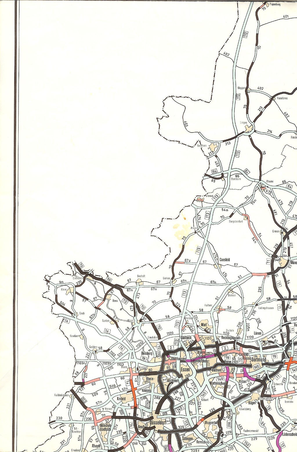
The Bundesautobahn 30 (abbreviation: BAB 30 ) - short form: Autobahn 30 (abbreviation: A 30 ) - is a motorway in Germany and runs in a west - east direction, starting at the Dutch border, to Bad Oeynhausen in Ostwestfalen-Lippe. At the border there is a connection to the Dutch A1 , which makes the A 30 part of the important European connection Amsterdam - Berlin - Warsaw ( Europastraße 30 ). Within Germany, it connects the Netherlands with Osnabrück , Minden and Hanover and Hanover with Münster .
Lines
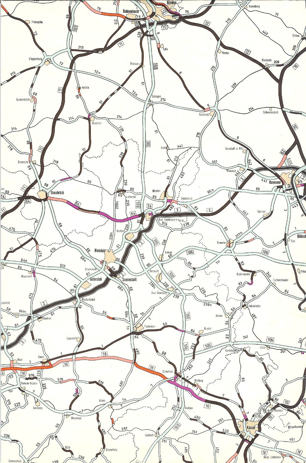
As an extension of the Dutch A1 motorway, the federal motorway 30 begins at the German-Dutch border between Nordhorn and Bad Bentheim and, following its course to the east, first crosses the federal motorway 31 at Schüttorf , so that direct connections to the south into the Ruhr area and on to Cologne as well to the north towards Emden exist. It continues past Rheine and crosses the A 1 southwest of Osnabrück in the Tecklenburger Land near Lotte , which provides connections to the north towards Bremen (A 1) and Oldenburg (A 1 and A 29 ) and south towards Münster (A 1) consist. Southeast of Osnabrück, the A 30 crosses the A 33 , which leads to the northeast, temporarily merging into the B 51 , to Diepholz and southeast to Bielefeld . About 50 kilometers further east, the A 30 ends at Bad Oeynhausen with a connection to the A 2 and then changes to the B 514 towards Vlotho .
Although the A 30 is quite straight, on its way from the Dutch border to the A 2 it crosses the state border between Lower Saxony and North Rhine-Westphalia three times (north of Rheine, southwest of Osnabrück and near Bruchmühlen ). The reason is that the state border has a meandering course here. If you continue to Hanover, you cross this border a fourth time (near Bad Eilsen ). This fact causes problems for truck drivers who want to drive from Bad Bentheim to Hanover on Corpus Christi or All Saints' Day . Because both days are working days in Lower Saxony, while in North Rhine-Westphalia they are public holidays , on which trucks over 7.5 t are generally prohibited from taking part in public road traffic. For “passages” (here: from Lower Saxony to Lower Saxony via North Rhine-Westphalia), however, it is possible to obtain a “special permit”. On the two public holidays in North Rhine-Westphalia, it is to be expected that an unusually high number of truck drivers who are not heading for a destination in Lower Saxony or any other area where the the day in question is considered a working day or who do not have a special permit.
history
The first plans go back to 1933, when an international road with the Netherlands via Oldenzaal , Bad Bentheim , Salzbergen and Rheine was planned. The network plans for the Reichsautobahn from 1938 to 1940 contained a route that should lead past Salzbergen to the south, Rheine to the north and Osnabrück to the south and meet today's A 2 in the Herford / Bielefeld area .
After the end of the Second World War , the section from Bad Bentheim to Osnabrück was initially only intended to expand federal highway 65 with a few bypasses. Accordingly, in the law on the expansion plan for the federal trunk roads of July 27, 1957, this route was only included as a federal road to be expanded with a length of 68.9 km. In 1961, the plans were changed to build the section as a new motorway-like building. The route regulations for the individual sections were made between 1966 and 1981.
In the first half of the 1950s, the states of Lower Saxony and North Rhine-Westphalia initially agreed on the construction of an efficient state road connection between Osnabrück and Bad Oeynhausen . The construction of a section between Melle and Bruchmühlen began in 1956. The law on the expansion plan for the federal highways of July 27, 1957 provided for the construction of a new federal road with a connection to the Hanover - Ruhr area and a length of 53.6 km for the route Osnabrück - Bad Oeynhausen . Nevertheless, the project was initially promoted as a four-lane, intersection-free state road 777n between Bruchmühlen and Löhne in North Rhine-Westphalia, and in 1963 and 1964 the line was determined according to state law. In contrast, the line of the Lower Saxony part between Osnabrück and Bruchmühlen was designated as a federal road in 1964 and 1965. In 1967 it was decided to continue construction as a federal motorway.
In the requirement plan of the law on the expansion of federal highways from 1971 to 1985 from June 30, 1971, the entire route from Bad Bentheim via Osnabrück to Bad Oeynhausen was managed under the internal designation "Autobahn 64" and planned for implementation. In contrast, the section Bad Oeynhausen - Minden - Stadthagen - Hanover-Laatzen was only included as a four-lane motorway-like federal road with the numbers 61 (Bad Oeynhausen - Minden) and 65 (Minden - Hanover). The expansion for the sections Rheine - Osnabrück - Bad Oeynhausen and Bad Oeynhausen - Minden - Bückeburg as well as for the bypass (OU) Stadthagen and for parts of the southern bypass Hanover (A 2 to B 3 ) was assigned to urgency level I. All other sections were classified in urgency level II.
With the restructuring and new numbering of the network of federal motorways, which was introduced with effect from January 1, 1975, the Bad Bentheim (border D / NL) - Rheine - Osnabrück - Bad Oeynhausen - Minden - Stadthagen - Laatzen train received the uniform name " Federal motorway 30 ". According to this plan, the A 30 should run north of Werste and Eidinghausen around Bad Oeynhausen. In the area of today's AS Dehme , a motorway triangle was to be built to connect the A 339 Bad Oeynhausen - Vlotho , which was planned at the time . After a northern bypass of the western districts of Dehme, the crossing of the B 61 and the southern guidance around the eastern districts of Dehme was intended. Then the expansion of the B 61 between Dehme and Porta Westfalica-Barkhausen was considered. The district of Barkhausen was to be bypassed to the east and connected to the B 65 south of Minden. The A 30 continued over the already completed Minden bypass (B 65) with a connection west of Bückeburg. The new line of the A 30 was then intended to run parallel to the B 65 to Stadthagen, with Bückeburg, Obernkirchen - Vehlen , Obernkirchen- Gelldorf and Nienstädt to the north being bypassed. To the south-east of Stadthagen, the crossing of the B 65 and the tour around Stadthagen was planned, so that a further connection to the B 65 should take place east of the city. The route between Stadthagen and Hanover was south of Lindhorst , north of Beckedorf , north of Bad Nenndorf (junction with the A 2), south of Barsinghausen - Goltern , north of Barsinghausen- Eckerde , north of Gehrden (junction with A 35 ), north of Ronnenberg , north of Hemmingen - Devese , north Hemmingen- Arnum and north Laatzen- Grasdorf to A 37 are provided.
The A 30 between Bad Bentheim and Hanover was also planned according to the law amending the law on the expansion of federal highways from 1971 to 1985 from August 5, 1976. However, the levels of urgency changed: the Rheine - Osnabrück - Bad Oeynhausen route was still in urgency level Ia, although large parts were already completed or under construction. The Bad Bentheim - Rheine section was one-lane with urgency level Ib, otherwise assigned to other needs. The section Bad Oeynhausen - Porta Westfalica was included in urgency level Ib, between Porta Westfalica and Minden in level Ia. With the exception of the sections under construction west of Bückeburg and the OU Stadthagen as well as the planned single-lane OU Bückeburg and a few short sections south of Hanover, the Minden - Hanover line was discontinued for further needs.
With the second law amending the law on the expansion of federal highways from 1971 to 1985 from August 25, 1980, the plans changed fundamentally. The Bad Bentheim - Rheine - Osnabrück - Bad Oeynhausen route was assigned urgency level I for the first time. The Bad Oeynhausen - Minden - Hannover-Laatzen section of the A 30 was, however, deleted from the requirements plan. The background to this was the review of parallel plans to the existing motorway network in the course of drawing up the Federal Transport Infrastructure Plan in 1980, because the planned route of the A 30 was sometimes only a few kilometers away from the A 2. Nevertheless, the B 61n Bad Oeynhausen - Minden (partially with four lanes) as well as the Bückeburg bypass (four lanes ) and the Großgoltern - Benthe route were planned in the course of the B 65 in urgency level I.
In the third law amending the Act on Motorway Expansion of April 21, 1986, the Bad Oeynhausen - Minden - Hanover section of the A 30 was deleted. There were also other changes to the projects that were to be carried out on the old route of the A 30. The Bad Oeynhausen - Porta Westfalica route was canceled without replacement. Between Bückeburg and Stadthagen the four-lane expansion of the existing federal road with individual bypasses was planned. A two-lane new construction solution was included from the A 2 at Bad Nenndorf and Benthe near Hanover. Apart from the sections of the A 30 between Bad Bentheim and Osnabrück, which were already under construction, only the Porta Westfalica - Minden route was still classified as urgent, while all other projects, including the Bad Oeynhausen bypass, were only included in further requirements.
The A 30 between Bad Oeynhausen, Minden and Hanover remained canceled according to the fourth law amending the law on the expansion of the trunk road of November 15, 1993. In the course of the B 65, the Vehlen bypass (additional requirement) and Nienstädt , the expansion of the existing B 65 between these two locations and between Stadthagen and Bad Nenndorf (all additional requirements) were planned. Furthermore, the two-lane new construction of the B 65 between the A 2 near Bad Nenndorf and Benthe near Hanover was still needed. Only the Bad Oeynhausen north bypass of the A 30 was prioritized in terms of urgent needs. The project of a new four-lane construction of the B 61 between Porta Westfalica and Minden was still being considered.
The federal traffic route plans for 2003 and 2030 did not result in the addition of the A 30 between Bad Oeynhausen and Hanover. Improvements are only planned here in the federal road network, so extensive two-lane re-routing and multi-lane extensions of the B 65 are planned.
As a result of the plan changes, the torsos of the A 30 construction remained, such as the bypass of Stadthagen and the southern bypass of Minden as part of the B 65 as well as parts of a planned junction in Laatzen, which is now used as a fairground. In the area of the Laatzener Festplatz, a railway bridge was already built over the planned motorway during the construction of the high-speed line Hanover – Würzburg of the DB . Today this bridge is only used for a connection to the fairground and for a footpath and bike path.
Open to traffic
| year | section | km | comment |
|---|---|---|---|
| 1966 | east of AS Gesmold (K 228) - AS Melle-Ost | 3.8 km | initially single-lane as a state road |
| 1967 | Lotte junction - west of Osnabrück-Süd junction | 13.8 km | initially as B 65 |
| 1968 | east of AS Bissendorf (K 228 near Himbergen) - east of AS Gesmold | 8.1 km | |
| 1969 | AS Löhne - AS Gohfeld | 3.5 km | of which 2 km on the A 30 route planned later |
| 1971 | west of AS Bruchmühlen - AS Löhne | 19.9 km | |
| 1971 | AK Porta Westfalica-Barkhausen / Minden - AS Porta Westfalica-Neesen | 1.5 km | Dedicated today as B 65 |
| 1973 | west of the Osnabrück-Süd junction - east of the Bissendorf junction | 8.3 km | |
| 1973 | AS Porta Westfalica-Neesen - Lower Saxony / North Rhine-Westphalia border | 2.9 km | Dedicated today as B 65 |
| 1976 | AS Melle-Ost - west of AS Bruchmühlen | 8.0 km | Expansion and reconstruction of a section of a state road that was completed in 1958 |
| 1976 | AS Ibbenbüren - AS Lotte | 13.1 km | |
| 1978 | Lower Saxony / North Rhine-Westphalia state border - to the east of skirts | 3.2 km | Dedicated today as B 65 |
| 1978 | west of AS Hörstel - AS Ibbenbüren | 10.9 km | |
| 1979 | OU Stadthagen | 4.9 km | Dedicated today as B 65 |
| 1980 | AS Bad Oeynhausen-Ost - AK Bad Oeynhausen | 1.1 km | |
| 1985 | State border D / NL - AS Schüttorf | 15.7 km | |
| 1986 | AS Rheine Canal Harbor - west of AS Hörstel | 1.0 km | |
| 1987 | AS Rheine-Nord - AS Rheine-Kanalhafen | 8.4 km | |
| 1990 | OU Bückeburg | 4.5 km | two-lane, dedicated as B 65 |
| 1991 | AS Schüttorf - AS Rheine-Nord | 12.9 km | |
| 2002 | OU Porta Westfalica-Barkhausen with Weserauentunnel | 2.7 km | four lanes, dedicated as B 61 |
| 2014 | AS Bad Oeynhausen-Nord - AS Dehme | 1.6 km | not signposted as a motorway, single-lane, only a maximum of 50 km / h allowed, construction site area |
| 2018 | AS Gohfeld (formerly AD Löhne) - AS Bad Oeynhausen-Ost | 8.5 km |
Construction of the northern bypass of Bad Oeynhausen


By 2018, the A 30 merged west of Bad Oeynhausen into the B 61 , on which traffic was directed through the health resort and which in the east of the city returned to the section of the A 30 between the Bad Oeynhausen-Ost junction, which was completed in 1980 (previously Rehme) and the A 2 (Kreuz Bad Oeynhausen) connected.
The closure of the autobahn gap near Bad Oeynhausen was planned for 38 years, although it was repeatedly delayed by disputes about the route. As alternatives to a northern bypass of the city, a route south of Bad Oeynhausen from the Löhne triangle to the A 2 near Exter ("southern bypass") and the route along the previous route through the city in trough construction were named.
In January 2007, the Detmold district government issued a planning approval decision for the construction of this last section of the A 30 as a northern bypass at the request of the State Road Construction Agency in North Rhine-Westphalia . The approximately 8.5 km long section will receive two new junctions, 28 bridges and a tunnel.
A citizens' initiative, which campaigned against the construction of the motorway, sued the planning approval decision before the Federal Administrative Court , which since December 2006 has been responsible in the first and last instance for proceedings in connection with larger motorway construction projects. In July 2008, the court dismissed the lawsuit as unfounded.
Construction began in September 2008, and completion was initially targeted for 2014. On March 12, 2014, the section between the Bad Oeynhausen-Nord and Dehme junctions was released with initially one lane per direction of travel, while the completion of the entire northern bypass was expected by the end of 2016. Due to objections from a company involved in the tendering process, the award of the contract for the fourth construction phase was delayed until October 2015; this was originally planned for May 2015. In 2016, the construction of the fourth and final construction phase began, which includes the redesign of the new AS Gohfeld (former motorway triangle Löhne) and the connection of the northern bypass to the existing part of the A 30 and the B 61. Parts of the completed but not yet released sections of the northern bypass were used as the location for the film Out of Control in February and April 2016 . The official opening of the northern bypass took place on December 6, 2018.
Traffic was opened on December 9, 2018, the section between Gohfeld and Bad Oeynhausen-Nord in the direction of Hanover was opened on December 13, 2018. After completing the remaining construction work in the area of AS Gohfeld (former motorway triangle Löhne), the entire construction project has been completed and the motorway in this section can be used without restrictions.
Movie
- Autobahn (film) , documentary about the traffic situation in Bad Oeynhausen and the construction of the northern bypass, 2019, 85 min., Script and direction: Daniel Abma , premiere: DOK Leipzig 2019, www.autobahn-film.de
Planned expansion measures
The A 30 is to be extended to three lanes in each direction in the section between the Lotte / Osnabrück intersection and the Osnabrück-Süd intersection. In the course of this project, the conversion of AK Osnabrück-Süd is also planned. The entire project is listed in the Federal Transport Infrastructure Plan 2030 as "Urgent need with elimination of bottlenecks" (VB-E).
See also
- List of federal motorways that are not motorways
- List of European roads
- List of federal motorways in Germany
Web links
- Detailed route description of the federal highway 30
- History of the A 30
- Straßen.NRW: The northern bypass of Bad Oeynhausen
- Description of the preliminary construction work in Laatzen near Hanover
Individual evidence
- ^ Corpus Christi: Truck driving bans in six federal states . trucker.de, June 2, 2010
- ↑ a b Federal Law Gazette 1957, Part I, p. 1189
- ↑ a b History of the A 30. Henning Maruhn, accessed on September 8, 2013 (Internet article ).
- ↑ Federal Law Gazette 1971, Part I, p. 873
- ↑ Construction work on federal trunk roads in 1972. Expansion of federal trunk roads from 1971 to 1985. Annex to the road construction report 1972. Federal Minister of Transport, Road Construction Department, accessed on March 31, 2013 (map excerpt).
- ↑ Construction work on federal trunk roads in 1972. Expansion of federal trunk roads from 1971 to 1985. Annex to the road construction report 1972. Federal Minister of Transport, Road Construction Department, accessed on March 31, 2013 (map excerpt).
- ^ Structure and numbering of the federal highways. Planned overall network. Federal Minister of Transport, Road Construction Department, June 15, 1974, accessed on September 18, 2013 (map excerpt).
- ↑ Der Große Shell Atlas, Mairs Geographischer Verlag, Stuttgart 1979/80, Bl. 23, 24, 204 and 205
- ↑ Federal Law Gazette, 1976, Part I, p. 2093
- ↑ Federal Law Gazette 1980, Part I, p. 1614
- ^ Federal Law Gazette 1986, Part I, p. 537
- ↑ Federal Law Gazette 1993, Part I, p. 1877
- ↑ bmvi: Bundesverkehrswegeplan 2030. Retrieved on May 10, 2017 (English).
- ^ Ministry of Building and Transport of the State of North Rhine-Westphalia: A30 north bypass for Bad Oeynhausen. A connection for Europe. (Leaflet) 2008.
- ^ Judgment of the Federal Administrative Court of July 9, 2008. Accessed on February 23, 2019 .
- ↑ wdr.de: A 30 may be expanded ( Memento from July 16, 2008 in the Internet Archive )
- ↑ Jörg Stuke: The first traffic jam on the northern bypass. (No longer available online.) Neue Westfälische, February 18, 2011, formerly in the original ; Retrieved June 25, 2011 . ( Page no longer available , search in web archives ) Info: The link was automatically marked as defective. Please check the link according to the instructions and then remove this notice.
- ↑ Northern bypass: Approval at the end of 2016 Neue Westfälische from February 6, 2015, accessed on April 29, 2015
- ↑ Neue Westfälische from August 19, 2015 (accessed on August 19, 2015)
- ↑ A 30: Construction of the Löhner Cross is to begin in May. Westfalen-Blatt, accessed on March 15, 2016 .
- ↑ WESTFALEN-BLATT: A30: Traffic routing will be changed . In: Westfalen-Blatt . ( westfalen-blatt.de [accessed on December 16, 2016]).
- ↑ A30 gap closure near Bad Oeynhausen. State Office for Road Construction North Rhine-Westphalia, accessed on March 15, 2016 .
- ↑ A 30 is again used as a location for an action film. Westfalen-Blatt dated March 30, 2016
- ↑ The traffic rolls on the new A 30. In: Westfalen-Blatt. Retrieved December 9, 2018 .
- ↑ Dossier. Retrieved November 11, 2017 .
- ↑ Federal Law Gazette . (PDF) Retrieved on November 11, 2017 (parliamentary confirmation by expansion law).
