
Danube Street


| State road B3a in Austria | ||||||||||||||||||||||

|
||||||||||||||||||||||
| map | ||||||||||||||||||||||
 |
||||||||||||||||||||||
| Basic data | ||||||||||||||||||||||
| Overall length: | 3.9 km | |||||||||||||||||||||
|
State : |
||||||||||||||||||||||
|
Course of the road
|
||||||||||||||||||||||
| State road B3b in Austria | ||||||||||

|
||||||||||
| map | ||||||||||
 |
||||||||||
| Basic data | ||||||||||
| Overall length: | 2.8 km | |||||||||
|
State : |
||||||||||
|
Course of the road
|
||||||||||
The Danube Street B 3 is a state road B in Lower Austria and Upper Austria , Main Street B in Vienna and former federal highway .
course
Marchfeld
The Donau Straße runs for a length of about 195 km from Engelhartstetten in the Gänserndorf district along the Danube on the left bank upstream to Linz , where it ends after one kilometer on the right bank. In Engelhartstetten, Donau Strasse begins at the intersection with Bernstein Strasse B 49 and leads over southern Marchfeld to Vienna .
Vienna
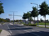
In the urban area of Vienna , where the street in the 22nd and 21st district mostly runs parallel to the Danube bank A 22 motorway, the name Donau Straße is rarely used in everyday language. The names of the local streets are used, namely the streets Esslinger Hauptstraße, Groß-Enzersdorfer Straße, Siegesplatz , Asperner Heldenplatz , Aspernstraße, Erzherzog-Karl-Straße , Donaustadtstraße, Siebeckstraße, Dückegasse, Angyalföldstraße, Katsushikastraße and Prager Straße , from where the Danube flows Road leads via Korneuburg to Stockerau .
Wein- and Waldviertel
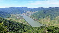
In Stockerau , Donau Straße joins Horner Straße B 4, which begins there . Between Stockerau and Krems an der Donau , Donau Straße has been replaced by Stockerauer Schnellstraße S 5. From Krems the Donau Straße leads through the Wachau , the Nibelungengau and the Strudengau . There are several connections to Wiener Straße B 1.
In 1959, Austria's largest and most modern federal road tunnel was put into operation near Dürnstein . In October 2018, still the second longest two-way traffic tunnel in Lower Austria, it will be modernized and technically updated in a construction period of five months. During this time it can only be bypassed over a large area. In addition to cars, only public buses and emergency vehicles are allowed to use the stairway for a short detour .
Mühlviertel
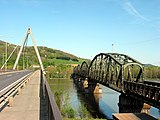
From Strudengau the Donau Straße leads over the Machland to Linz, where it crosses the Danube bridge Steyregg and ends at the VOEST junction of the Mühlkreis Autobahn A 7. As a continuation on the northern bank of the Danube, the Prague federal highway B 125 branches off in front of it .
history
The Mauthausener Straße between Linz and Emmersdorf belonged to the network of federal highways in Austria from January 1st, 1950 . It used to be called Hauderer Straße in Upper Austria .
The Stein-Straße Emmer on the northern bank of the Danube between Krems and Emmersdorf one of the streets in Lower Austria, which have been declared by the Federal Law of 2 June 1954 federal roads. In the federal budget of 1954, 15,000,000 schillings were made available for the expansion of these roads.
The Marchegger Straße between Groß-Enzersdorf and Engelhartstetten belonged to the network of federal highways in Austria from April 1, 1959 . According to the Federal Roads Act of 1971, the Marchfeld expressway S 1 was to replace Marchegger Strasse. However, this expressway was not built, so on April 1, 1983 the federal highway B 3 was extended to Engelhartstetten. Before that, the B 3 ended in Aspern on September 1, 1971 at the planned, but never built, Vienna outer ring, the A 21 motorway .
On January 1, 1972, the new line between Stockerau and Krems replaced Stockerau-Kremser Strasse via Hausleiten and Kirchberg am Wagram , which had served as a federal road since 1948 and was therefore downgraded to state road L 14. The Stockerau-Kremser Straße has been known as the B 3 since 1949 , this number has been used for the entire Donau Straße since 1971.
Since September 12, 1979, the Donau Straße has been running westwards over the newly built Danube bridge near Steyregg for two kilometers to the A 7 exit 7 (Voestalpine), before that it ended five kilometers further north (today L 569) on the B 125 Prague federal highway in Linz - Katzbach .
From 1997 the section between Stockerau and Tulln was called Stockerauer Straße B 304. Through the Federal Road Transfer Act of March 29, 2002, the route between Stockerau and Krems to the Stockerau expressway S 5 and the remainder of the Danube Road B 3 was transferred to the administration of the federal states .
Branch lines
In Austria, short branches with high traffic significance are given a number with an attached letter.
With the opening of the Danube bridge between Emmersdorf and Melk in 1972, Melker Straße B 3a was created. This connects the B 3 on the northern bank of the Danube with the Melk junction on the West A 1 motorway south of the Danube and acts as a bypass road past the city of Melk.
In connection with the extension of the B 3 to Engelhartstetten, the 1.7 km long southern section of the Donaustadtstrasse between Erzherzog-Karl-Strasse and the Kaisermühlen junction ( Danube bank Autobahn A 22 / Autobahn Südosttangente Vienna A 23) has been known as the Donaustadt Strasse B 3b . Until the further construction of the A 23 in 1993, it had to accommodate most of the traffic coming north from the Prater Bridge .
Until the opening of the Perg bypass on August 28, 1999, the Donau Straße ran through the urban area of Perg. After the transfer of the B 3 to the bypass road, the approximately six kilometer long western part of the previous Perger local passage was renamed the B 3c , and the eastern section was downgraded to the municipal road.
gallery
B3 on Angyalföldstraße towards Kagran
Danube bridges near Steyregg , to the east

Exit Krems-Zentrum
B3 on the northern bank of the Danube in the St. Michael / Spitz area


.JPG)
Web links
Individual evidence
- ↑ until 1999 officially Eßling
- ↑ until 1999 officially Eßlinger ...
- ↑ Dürnstein tunnel blocked for five months on ORF from October 27, 2018 accessed on October 27, 2018
- ↑ Federal Roads Act of February 18, 1948, Directory C.
- ^ Ordinance of the Upper Austrian provincial government of December 29, 1931, regarding the renaming of the more important public roads in Upper Austria, with the exception of federal roads. LGBl. No. 15/1932.
- ↑ Federal Act of June 2, 1954, Directory E.
- ↑ Federal Act of March 18, 1959, with which the Federal Roads Act is again amended, Directory H.
- ↑ a b Federal Act of January 20, 1983, with which the Federal Roads Act 1971 is changed. BGBl. 63/1983.
- ^ Announcement by the Federal Minister for Buildings and Technology of October 17, 1973 in accordance with Section 33 (4) of the Federal Roads Act 1971 with regard to the State of Vienna. Federal Law Gazette No. 545/1973.
- ^ Announcement by the Federal Minister for Buildings and Technology of June 10, 1976 in accordance with Section 33 (4) of the Federal Roads Act 1971 with regard to the State of Lower Austria, Federal Law Gazette No. 337/1976.
- ↑ Federal Roads Act 1999, Federal Law Gazette I No. 182/1999
- ↑ Perg bypass (PDF; 916 kB)
| B3 | Like the other former federal highways, Donau Strasse was part of the federal administration. Since April 1, 2002, it has been under state administration and continues to have the B in the number, but not the name Bundesstraße. |