
Sainte-Barbe (Vosges)
| Sainte-Barbe | ||
|---|---|---|
|
||
| region | Grand Est | |
| Department | Vosges | |
| Arrondissement | Epinal | |
| Canton | Raon-l'Étape | |
| Community association | Region of Rambervillers | |
| Coordinates | 48 ° 24 ' N , 6 ° 43' E | |
| height | 286-476 m | |
| surface | 30.38 km 2 | |
| Residents | 278 (January 1, 2017) | |
| Population density | 9 inhabitants / km 2 | |
| Post Code | 88700 | |
| INSEE code | 88410 | |
 Town center |
||

Sainte-Barbe is a French commune in the Vosges department in the Grand Est region (until 2015 Lorraine ). It belongs to the Arrondissement Épinal and the canton Raon-l'Étape .
geography
The municipality is located on the western edge of the Vosges , about twelve kilometers northeast of Rambervillers . Neighboring municipalities of Sainte-Barbe are Deneuvre in the north, Lachapelle and Thiaville-sur-Meurthe in the northeast, Raon-l'Étape in the east, Étival-Clairefontaine in the southeast, Saint-Benoît-la-Chipotte in the south, Ménil-sur-Belvitte in the West as well as Bazien in the northwest.
Population development
| year | 1793 | 1896 | 1954 | 1982 | 1990 | 1999 | 2006 |
| Residents | 421 | 599 | 339 | 267 | 251 | 251 | 281 |
Attractions
- St. Barbara Church
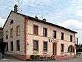
town hall

St. Barbara Church


Web links
Commons : Sainte-Barbe - Collection of images, videos and audio files