
Helmstedt
| coat of arms | Germany map | |
|---|---|---|

|
Coordinates: 52 ° 14 ' N , 11 ° 1' E |
|
| Basic data | ||
| State : | Lower Saxony | |
| County : | Helmstedt | |
| Height : | 123 m above sea level NHN | |
| Area : | 66.54 km 2 | |
| Residents: | 25,712 (Dec. 31, 2019) | |
| Population density : | 386 inhabitants per km 2 | |
| Postcodes : | 38350, 38372 | |
| Primaries : | 05351, 05352, 05356 | |
| License plate : | HE | |
| Community key : | 03 1 54 028 | |
| LOCODE : | DE HEL | |
| City structure: | 8 districts | |
City administration address : |
Market 1 38350 Helmstedt |
|
| Website : | ||
| Mayor : | Wittich Schobert ( CDU ) | |
| Location of the city of Helmstedt in the Helmstedt district | ||
  |
||

Helmstedt ( Low German Helmstidde ) is the district town of the Helmstedt district in Lower Saxony ( Germany ) and an independent municipality . It is between Elm and Lappwald , about 36 km east of Braunschweig and about 45 km west of Magdeburg on the border with Saxony-Anhalt .
During the division of Germany , the most important border crossing ( control point Helmstedt ) between the Federal Republic of Germany and the German Democratic Republic and the western end point of one of the transit routes to West Berlin was located here on Federal Motorway 2 . The counterpart as a border station was the Helmstedt station .
Helmstedt owns buildings that go back to the Romanesque period. Examples from the Renaissance period as well as over 400 professorial and half-timbered houses from the 16th and 17th centuries should be emphasized .
The former university and Hanseatic city is located in the middle of the Elm-Lappwald nature park . The city is also a member of the “ New Hanseatic League ”.
geography
Geographical location

The district town of Helmstedt lies in the transition area between the northern Harz foreland and the northern German lowlands in a depression ( Helmstedter Mulde ) between the ridges of Elm (about 10 km to the west) and Lappwald , which is directly adjacent to the urban area.
The urban area extends over an area of 46.97 km² and, with the districts, has a north-south extension of a good nine kilometers or eight kilometers in a west-east direction. The inner city area is characterized by a hilly location, so that the height information sometimes differ considerably. In the inner city area the lowest point is at 123 m above sea level (measuring point Albrechtstrasse ), the highest point at 144 m above sea level (measuring point Eulenturm ). In the entire urban area, the highest elevation is the Bötschenberg with 171.6 m above sea level, the lowest point in the city is 114.1 m above sea level (measuring point Mühlgraben ).
Geographically, Helmstedt lies at 52 ° 13 'north latitude (measuring point Rathaus ) and 11 ° east longitude and thus on the same latitude as Amsterdam and Warsaw and the same longitude as Erfurt and Augsburg . The 11th degree of longitude runs directly through the city area at the west portal of the Marienberg Monastery .
In a clockwise direction , starting in the northeast, the following municipalities border Helmstedt: Oebisfelde-Weferlingen , Beendorf , Ingersleben , Sommersdorf , Harbke , (all in the Saxony-Anhalt district of Börde ), Schöningen , Wolsdorf , Süpplingen , Süpplingenburg and in the north of Mariental (all in the district Helmstedt ).
The closest major cities are Braunschweig (about 36 km to the west), Wolfsburg (about 30 km to the northwest) and Magdeburg (about 45 km to the east). The capital of Lower Saxony, Hanover , is about 90 km to the west.
City structure
Helmstedt is divided into eight districts:
The core city comprises the area of the traditional old town as well as the adjacent new settlement areas, which were mainly created after the Second World War . Around 21,100 people live in this district. The two districts of Barmke (around 820 inhabitants) and Emmerstedt (around 2270 inhabitants) are 4.5 km and one kilometer northwest of the core city and were incorporated into Helmstedt in 1974 as part of a regional reform . Settled in the 19th century and located in the middle of the Lappwald, Bad Helmstedt (around 150 inhabitants) is about 3.5 km east of the city center. To the southeast of the city center are Büddenstedt , Hohnsleben , Offleben and Reinsdorf , which came to the city on July 1, 2017 with the incorporation of Büddenstedt.
Localities were formed for the following districts:
- Barmke
- Emmerstedt
- Büddenstedt
- Offleben (with Hohnsleben and Reinsdorf)
.png&filetimestamp=20100427094422&)
climate
The city of Helmstedt lies within the moderate latitudes in the transition area between oceanic and continental areas. The annual mean temperature is 8.9 ° C, the average annual rainfall is 608 mm. The warmest months are July and August with an average of 17.6 ° C and 17.3 ° C and the coldest January and February with an average of 0.3 ° C and 0.8 ° C. Most of the precipitation falls in June with an average of 76 mm, the lowest in October and February with an average of 39 mm. Around 1370 hours of sunshine are registered all year round, with the most sunshine being expected in June, at 6.2 hours a day.
history

Early history
Helmstedt and the surrounding area are rich in archaeological sites. The oldest traces of people present here were found during the excavations in the Helmstedt lignite mining area , including the 300,000-year-old Schöninger spears . The loess ran right through the Helmstedt district - also a cultural boundary. While peasant cultures had already settled on the fertile loess soils in the Neolithic , Middle Stone Age hunters and gatherers still lived north of Helmstedt in the areas with poor soil quality . The oldest settlements were built by the peasants of the Neolithic Age in the 6th millennium BC. The first rural culture north of the loess border was characterized by its special ceramics in the form of funnel cups . These people buried their dead in large stone graves. The Lübbensteine west of Helmstedt from the 4th millennium BC are also known. BC as well as the large stone graves near Süpplingenburg and Groß Steinum .
middle Ages

Helmstedt developed near the Benedictine monastery of St. Ludgeri , which was probably founded around 800 as a mission cell by Liudger , the first bishop of Münster. There was always a close connection to the Werden monastery (today a district of Essen ), which has been documented since the middle of the 12th century. The oldest political division of the region goes back to the Gaue in the early Middle Ages. The Helmstedt region was part of Derlingau and Northern Thuringia . During the Middle Ages, the counties replaced the districts. About Emperor Lothar III. von Süpplingenburg the surrounding Helmstedt possessions fell to the Welfs . Until 1490, the abbots of Werden-Ludgeri monastery were the city lords of Helmstedt, who then ceded their rights to the dukes of Braunschweig-Lüneburg .
Helmstedt was first mentioned as Helmonstede in a document from King Otto I in 952. Securitized city rights are documented for Helmstedt as early as 1247 by the abbot of Werden.
In the course of the German throne dispute between the Guelphs and Staufers , the city was almost completely destroyed at the turn of the year 1199/1200 by the troops of the Magdeburg Archbishop Ludolf and King Philip of Swabia . After the reconstruction, the fortifications of the city were strengthened, so that a siege in 1279 during the Guelph inheritance disputes between the sons of the late Duke Albrecht the Great could be withstood. After years of armed conflict, the abbot of Werden Otto II , who was active as a mediator between the warring parties, was killed in 1288 by angry citizens of Helmstedt under circumstances that were not clarified. As a result, the imperial ban was imposed on the city and its citizens , which was not repealed until 1290 by King Rudolf I.

Due to its favorable traffic situation between the trade routes Lüneburg-Halberstadt and Braunschweig-Magdeburg, Helmstedt developed into a very important trading center at an early stage. Between 1426 and 1518 there was a membership in the Hanseatic League of Towns , albeit as the smallest member.
Christianization and Reformation
The monastery complex of St. Ludgeri in Helmstedt goes back to the mission time around the year 800. Founded as an offshoot of the Werden monastery near Essen, St. Ludgeri resisted the Reformation and for a long time was the only Catholic community in the region. In 1530 the first evangelical sermon took place in the Stephani church in Helmstedt. The Reformation prevailed in the city of Helmstedt against the resistance of the Ludgeri monastery and the Catholic Duke Heinrich , and the monastery was pillaged, among other things. The surrounding area remained Catholic. Only Duke Julius introduced the Reformation immediately after taking over the government in 1568 in the state of Braunschweig, and thus also in the area of the later district of Helmstedt.
University of Helmstedt

The University of Academia Julia was founded by Duke Julius on October 15, 1576; his son Heinrich Julius was the first rector. The university had a significant impact on life from 1576 to 1810 in the city, which had since become a member of the Hanseatic League . The dukes brought in scholars such as the humanist Georg Calixt , the great unification theologian who founded a school of philosophy here, the universal scholar Hermann Conring , doctor of medicine, theology, philosophy and lawyer at the same time, or the famous Italian Giordano Bruno , who did the teaching of Copernicus and therefore ended up on a stake in Rome years later, at the University of Helmstedt. In his memoirs, published worldwide in 1741, the German imperial count and later field marshal Georg Ludwig Albrecht von Rantzau tells of his sensational experiences as a student in Helmstedt.
All these scholars published their well-known works on the university printing press of the "Typographus" and master of the woodcut Jacob Lucius , who had already worked with Lucas Cranach the Younger in Wittenberg . So it was necessary to operate the printing press in "tremendous" degree, which, thanks to the generous expansion of the university printing office in conjunction with the establishment of the Municipal bookstore by Board SAT remote dealers and merchants, especially Helmstedter patrician family fire , resulted in Helmstedt quickly advanced to become Lower Saxony's most important book production facility.
In the winter of 1790/1791, a week-long conflict between students at the university and the town's craftsmen led to the student riots at the University of Helmstedt , which in February 1791, after a heavy tumult on the market in front of the official residence of Mayor Georg Fein , led to an exit of the students led to the neighboring village of Harbke . After the intervention of the government of the Principality of Braunschweig-Wolfenbüttel and the mediation of the mayor between the disputing parties, the students returned to the university town on March 2, 1791.
The university influenced the development of the city for almost 234 years. The ensemble of university buildings with the Juleum as the main building is still an architectural feast for the eyes. Fundamental changes occurred during the "French period" from 1806 to 1813. Jérôme Bonaparte , Napoleon's brother, ruled the Kingdom of Westphalia , to which Helmstedt also belonged. On his orders of December 10, 1809, the university was finally shut down after the end of the winter semester on May 1, 1810. Interventions by numerous important university members, including the theology professor Henke , were unsuccessful.
From the 19th century to the Weimar Republic

The closure of the Helmstedt University in 1810 meant a major economic and cultural setback for the city. In the following years it was possible to establish a good school system, which made Helmstedt known beyond the state's borders as a “school town” (famous students of the local grammar school were among others Hoffmann von Fallersleben and the brothers Adolf and Bruno Heusinger ), but the loss of meaning did not materialize however, do not stop completely.
Following an administrative act in the Duchy of Braunschweig , the ducal district directorate of Helmstedt was founded on January 1, 1833, consisting of the offices of Helmstedt, Schöningen, Königslutter, Vorsfelde and Calvörde . The district office was given its seat in the current building of the Zone Border Museum (Villa Heinemann) in Helmstedt.
From 1814 to at least 1846, games of chance were held on a small scale - only for bathers - under police supervision during the summer months in the Kurhaus Gesundbrunnen (in the Brunnental).
The city received its first economic impetus from the opening of the Helmstedt-Jerxheim railway line in 1858 and, in particular, from the rail connection to the Braunschweig-Helmstedt-Magdeburg line in 1872. With the establishment of the empire in 1871 and the subsequent industrial development of the country, there was also an increase There was also a need for energy sources, so that the lignite mined in the area around Helmstedt for decades was now increasingly in demand in ducal pits. In 1872, Duke Wilhelm sold his mining facilities for 6 million gold marks to a bank consortium, from which the Braunschweigische Kohlen-Bergwerke AG (BKB) emerged. This company, based in Helmstedt, promoted lignite extraction and power generation and shaped the landscape and the livelihood structure of the Helmstedt population for many decades with open-cast mine developments. In 1874, the first open-cast mine, “Trendelbusch”, was put into operation.
During the First World War , Helmstedt was spared direct combat operations due to its central location in the German Empire. In addition to restrictions on freedom of the press and freedom of expression, the war had an impact on the food supply, which, like electricity, was rationed. The Helmstedt population only came into direct contact with foreign soldiers with prisoner-of-war Russian-Polish officers after a POW camp was set up in the Gesundbrunnen excursion restaurant in Bad Helmstedt . After the defeat of the German Empire, the city recorded 626 citizens who died in the war. In the post-war chaos of November 1918, a workers 'and soldiers' council was also formed in Helmstedt . The general strike triggered by the Spartakists in the newly founded Free State of Braunschweig was fought down on April 15, 1919 in Helmstedt by the Freikorps Maercker ("Landesjäger") with armed force. Fighting between Spartakists and the Landesjäger Freikorps broke out in the city, which also claimed victims among the citizens.
The inflation and unemployment in the Weimar Republic also hit the people of Helmstedt hard. The Helmstedt Employment Office, created in 1927, reported a new high level of unemployment in the district in January 1933.
National Socialism and World War II

The takeover of power by the National Socialists in the German Reich also led to the synchronization of the media and the administrative structures in Helmstedt . As early as 1933 there were riots against the relatively small Jewish community in the city. On August 17, 1936, the Braunschweig-Helmstedt section of the Reichsautobahn 6 (today Federal Motorway 2 ) and the completed bridges (including the Brunnental Bridge and the Maschtal Bridge ) were opened to traffic. The plans for the autobahn were largely worked out before the handover of power to the National Socialists.
With the outbreak of World War II , urban life was also severely restricted. Helmstedt was not spared from air raids. On January 2, 1944, an Allied bomber crashed over Bad Helmstedt and damaged a hospital . The heaviest targeted bombing of the city took place on February 20, 1944 as part of the " Big Week ". Because the actual target of Halberstadt was under clouds and the bomber units could not identify it, Helmstedt was selected as an alternative target (“target of opportunity”). At that time, there were some important war armaments factories at the Emmerstedter street in Helmstedt and an airbase of the German Luftwaffe in the nearby Mariental-Horst . 58 B-24 bombers dropped their bomb load between 1:23 p.m. and 1:27 p.m., killing 126 people. Buildings on Poststrasse / Kleiner Wall and the railway bridge over Magdeburger Strasse were particularly affected. There was also considerable damage in the area of Elzweg, Henkestrasse, Vorsfelder Strasse and Schulstrasse.
In March 1944, the nearby Beendorf subcamp (often referred to as the Helmstedt-Beendorf concentration camp ) was built, in which several thousands of prisoners had to work in underground tunnels for aircraft production by the German Reich . The logistics of this satellite camp were partly carried out directly via Helmstedt.
At noon on April 12, 1945, the city of Helmstedt was handed over to the American tank units advancing west on Reichsstrasse 1 (today Bundesstrasse 1 ) through the mediation of the then NSDAP mayor Curt Drechsler and other city representatives.
Inner German border town
After the end of the Second World War, Helmstedt was in the British zone of occupation . On June 5, 1945, British occupation forces took control of the city, replacing the American units. According to the provisions of the Potsdam Conference , the Soviet occupation zone ended on the other side of the former Brunswick-Prussian border and thus in the immediate vicinity of the district town of Helmstedt. The Calvörde exclave , which originally belonged to the district , was added to the Soviet zone. On July 1, 1945, a permanent checkpoint was set up on the Reichsautobahn; the Helmstedt station became a border station , through which initially only allied transit traffic to Berlin was handled. During the Berlin blockade between June 1948 and May 1949, however, this traffic came to a complete standstill. In the following years, the bulk of the transit traffic between West Germany and Berlin was handled via the Helmstedt checkpoint due to the geographical proximity to West Berlin .
After the founding of the GDR in October 1949, the expansion of the border installations was pushed forward by the East German side, so that the city of Helmstedt lost access to its eastern environs. An exception was the Harbke power station , which was within sight of the city and was now in the border area of the GDR and ensured a cross-border power supply. Employees of the West German Braunschweigischen Kohlen-Bergwerke AG (BKB) were able to do their work here as well as in the open-cast lignite mines near the border. After the Harbke power plant was nationalized as a state-owned company by the GDR in 1952 and the border in this area was completely closed, Helmstedt's power plant was supplied from 1954 by the newly built Offleben power plant .
The immigration of displaced persons from the former German eastern areas and the stream of refugees from the Soviet occupation zone after the Second World War caused the city's population to skyrocket. While Helmstedt had around 18,000 inhabitants before the war, just under 30,000 inhabitants were registered in the mid-1950s. Attempts were made to take account of this increase in population through extensive development of new residential and commercial areas. As a result of the peripheral location on the inner-German border , which had existed for decades , the city steadily lost its inhabitants again.
On November 17, 1967, Neumärker Strasse was opened as a pedestrian zone , making it one of the first traffic-calmed shopping streets in what was then Germany.
In 1973, the Helmstedt open-cast mine to the south of the city was opened up in the local area , which for many years extracted lignite, but also shaped the directly adjacent landscape.
Reunion and the present

When the turning point in the GDR was initiated on November 9, 1989 , this also had direct effects on the Lower Saxony border town of Helmstedt. On the night of November 10, many GDR citizens crossed the Helmstedt-Marienborn border crossing . In the following days, the city experienced an unexpected rush of visitors from its eastern neighbors. By the end of 1989, almost all road connections that had been closed for decades through the inner German border were reopened by the GDR border troops , for example to Harbke , Morsleben or Beendorf . Even before the monetary, economic and social union between the two German states came into force in mid-1990, identity checks were dropped on both sides. With the German reunification on October 3, 1990, Helmstedt finally lost the role of a remote border town and was faced with new challenges. A not inconsiderable number of East German emigrants let the city population grow again for a short time. With the discontinuation of the West German zone border funding and simultaneous state subsidization of neighboring regions in Saxony-Anhalt, the district town arose new competition in terms of business settlements and sales markets. The city of Helmstedt tried to counteract this development by creating a commercial area on the eastern edge of the city (“Magdeburger Berg”) and making it more attractive by investing in the infrastructure.
In June 1992 the 12th day of Lower Saxony could be celebrated in Helmstedt. In line with the special role of the city during the division of Germany , the Zone Boundary Museum was opened in 1994 . The Helmstedt University Days have also been held annually since 1995 .
The Helmstedt open-cast lignite mine that was created during the division was shut down in 2002. In its place, a four-square-kilometer lake with a corresponding recreational value has been created from 2006 to around 2030, which as the Lappwaldsee (former project name Helmstedt-Harbke-See ) fills very slowly with groundwater.
In 2005, the last section of the bypass road ring around Helmstedt was opened to traffic.
Origin of the place name
Old names of the place are 952 Helmonstedi, end of the 10th century Helmonstedi, 10./11. Century Helmonstedi, 1012 Helmanstidi, around 1050 Helmunstedi, 1119 Helmonstede, 1126–1133 Helmenstad, around 1150 Helmenstide, around 1150 Helmenstad, 1159 Helmonstat, 1162 Helmestaden, 1176 Helmenstide, 1178–1179 Helmestedunum, 1182 Helmenstad, 1195 Helmenstad, 1192 Helmenstat, 1202 Helmenstad and around 1203 Heilminstede.
The basic word is "-stedt". It is named after the location, which is characterized by the topography. There are inclines and declines within the city center, and thus there is probably a connection with "kel" ("protrude, high"). Helmstedt probably means "place on an elevation, place on a slope".
Incorporations
On March 1, 1974, the communities of Barmke and Emmerstedt were incorporated. On July 1, 2017, Helmstedt merged with the neighboring municipality of Büddenstedt to form the new city of Helmstedt.
Postal history
Postal historians assume that there was a post office in Helmstedt since 1665. In the time of the Kingdom of Westphalia (1807-1813) the city belonged to the Oker department with the capital Braunschweig. District cities were Braunschweig, Helmstedt, Hildesheim and Goslar.
For the development of the postal system in Helmstedt, see: Braunschweig-Helmstedt-Magdeburg postal route .
population
Religions
The majority of the population has oriented itself towards the Christian doctrine since the city was founded . Helmstedt was for many centuries under the strong influence of the surrounding monasteries ( monastery Ludgeri , Klostermarienberg , monastery Mariental ) that shaped the cultural and religious life of the inhabitants. The abbots of the neighboring Ludgeri monastery ruled the town until 1490.
The Reformation movement found supporters in the city very early. Monks had been preaching Lutheran doctrine in Helmstedt since 1524, and the first Protestant service was held in St. Stephen's Church in 1530 by pastor Heinrich Wende. The Reformation finally took hold in the Duchy of Braunschweig-Lüneburg only after Duke Julius had ascended to the throne in 1568, and the parishes of the city of Helmstedt converted to Protestantism . Only the Ludgeri monastery adhered to the Catholic doctrine.
Today around 49 percent of the population profess to the Evangelical Lutheran Church (as of 2010). They are organized in the Evangelical Lutheran Church in Braunschweig and use eight places of worship that are spread over the entire city area: St. Marienberg , St. Stephani , St. Walpurgis , St. Michaelis, St. Thomas , St. Christophorus and St. Petri in Emmerstedt and the village church in Barmke. Around 12 percent of the Helmstedt population have a Roman Catholic denomination (as of 2010). They are assigned to the parish of St. Ludgeri in the Hildesheim diocese .
Jewish residents have been mentioned in a document in Helmstedt since 1247, when the abbot of the Ludgeri monastery, as the lord of the town, described the city rights of Helmstedt and imposed a special tax or protection fee on the Jews. In the Middle Ages, the Jewish residents of the city mostly lived in the area of today's Georgienstrasse . In exchange for a large sum of money from the city council to the responsible prince of the church, the abbot issued a ban on Jews living in Helmstedt in 1479. The ducal residence ban for Jews in the entire Principality of Braunschweig-Wolfenbüttel , which was later also imposed, was handled particularly restrictively in the city of Helmstedt. It was not until 1806 that this ban was lifted by the French occupying forces during the Napoleonic era , against the resistance of the Helmstedt city council . In the years that followed , the Jewish community remained very small and dissolved during the National Socialist era . Nowadays there is no longer any noteworthy Jewish community life in Helmstedt.
With increased immigration of Muslim migrants (especially from Turkey) in the 1960s and 1970s, Islamic religious communities also formed in Helmstedt.
Following a general socio-cultural trend, the number of non-denominational residents has been increasing steadily for several decades.
language
In Helmstedt and the surrounding area, the regional dialect of eastern Ostfälisch is still occasionally spoken, which is a variant of Lower Saxony and is also known colloquially as Low German . With increasing mobility and the associated migration movements of the population, especially from the 19th century onwards, it was replaced by High German .
Population development


The city's population has fluctuated considerably over the centuries due to armed conflicts, famine and epidemics. The plague epidemics of the 17th century, in particular , claimed a large number of victims. During the Thirty Years' War , a third of the population of Helmstedt fell victim to the plague of 1625. In November 1625, 295 town houses were empty.
Due to increasing urbanization in the course of industrialization in the second half of the 19th century, the population of the city of Helmstedt also grew by leaps and bounds. A considerable increase in population took place immediately after the end of the Second World War, when the number of inhabitants rose by a third within a short time due to the refugees and displaced immigrants from the former German eastern regions . Due to its location on the inner-German border and the associated unfavorable economic development, the city lost its inhabitants again in the period that followed. The incorporation of the two districts of Emmerstedt and Barmke in 1974 as well as the people who moved after German reunification in 1990 were only able to compensate for this negative trend for a short time.
|
|
|
Note: Population figures are given according to the respective area. Until 1830 it is mostly an estimate, then census results or official updates from the respective statistical offices or the city administration itself.
politics
The city of Helmstedt belongs to the 8th state electoral district and 52 to the federal electoral district of Helmstedt - Wolfsburg .
City Council
The local election on September 24, 2017 became necessary due to a merger with the neighboring municipality of Büddenstedt. Since then, the council of the city of Helmstedt has consisted of 38 councilors. The council members were elected for four years by this local election.
The full-time mayor Wittich Schobert (CDU) is also entitled to vote in the city council.
The last local elections produced the following results:
| Parties and constituencies | % 2017 |
Seats 2017 |
% 2016 |
Seats 2016 |
% 2011 |
Seats 2011 |
|
|---|---|---|---|---|---|---|---|
| CDU | Christian Democratic Union of Germany | 40.87 | 15th | 34.60 | 12 | 35.73 | 12 |
| SPD | Social Democratic Party of Germany | 33.68 | 13 | 35.50 | 12 | 40.39 | 14th |
| AfD | Alternative for Germany | 6.39 | 2 | 8.10 | 3 | - | - |
| FDP | Free Democratic Party | 4.71 | 2 | 6.10 | 2 | 3.47 | 1 |
| GREEN | Alliance 90 / The Greens | 4.17 | 2 | 7.00 | 2 | 8.09 | 3 |
| left | The left | 3.71 | 1 | 3.00 | 1 | 2.63 | 1 |
| HWG | Helmstedt community of voters | 1.88 | 1 | - | - | - | - |
| NPD | National Democratic Party of Germany | 1.87 | 1 | 2.40 | 1 | 3.53 | 1 |
| UWG | Independent voter community | 1.68 | 1 | 3.20 | 1 | 2.85 | 1 |
| NEO | New Helmstedt | 1.04 | - | - | - | - | - |
| total | 100.0 | 38 | 100.0 | 34 | 100.0 | 34 | |
| Voter turnout in% | 66.66 | 48.91 | 49.83 | ||||

mayor
Since November 1, 2011, the CDU politician Wittich Schobert has been the city's full-time mayor . In the last mayoral election on September 24, 2017, he won a direct election with 55.50% of the votes cast against three competitors. The turnout was 66.6%.
coat of arms
In the upper part of the city arms, the spiritual influence on Helmstedt is made clear by the holy Ludger . It is enthroned under a cloverleaf-shaped architectural arch with red roofs and the inscription "S.LUDGER". The saint wears a white robe with a red chasuble . In his right hand he holds a golden crook. In his left hand a gold book and a halo of the same kind. In the lower part of the coat of arms a silver tin wall with an open door is shown, which at that time reflected the term "city". Blue was chosen for the color of the Helmstedt coat of arms, white for the figure of the saint and white for the masonry. The city colors are therefore naturally blue and white. The image of Saint Ludger was approved on May 25, 1900 as the final coat of arms of the city by Prince Albrecht , the then regent of the Duchy of Braunschweig .

In addition to the official coat of arms, Helmstedt also has an old or actual coat of arms. It depicts two golden, diagonally crossed crooks on a red background. The coat of arms has its origin in the Reichsabtei Werden-Helmstedt , which existed as a state in two separate areas in the Middle Ages, in Werden an der Ruhr, a current district of Essen , and Helmstedt. In the 19th century the coat of arms was replaced by the motif of the city seal , presumably due to ignorance of the differences between a seal and a coat of arms, as it can be seen in the official coat of arms to this day.
Town twinning
Helmstedt has been on friendly terms with other Western European cities since the 1950s. After the fall of the Iron Curtain , these activities were expanded to Eastern Europe. There is currently an official international partnership with the following cities :
-
 Vitré in France since 1978
 -
 Chard in the UK since 1980
 -
 Albuquerque in the United States since 1983
 -
 Fiuggi in Italy since 1986
 -
 Haldensleben in Germany since 1990
 -
 Svetlahorsk in Belarus since 1991
 -
 Orăștie in Romania since 2002
 -
 Konakli in Turkey since 2008
Sponsorships
Since 1999, the city has been the namesake of a CRJ100LR airliner , which belongs to the Lufthansa CityLine fleet and bears the aircraft registration D-ACJJ.
Culture and sights
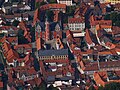
Its historical structure, its crooked squares and the fortifications surrounding the old town give Helmstedt an unmistakable profile in the Braunschweig region.
The cityscape is u. a. characterized by the double chapel St. Peter and Paul / St. Johannes, one of the oldest structures in the region, the St. Felicitas crypt of the St. Ludgeri monastery church , the parish church of St. Stephen, the St. Marienberg monastery , the complex of the former University with the Juleum auditorium as well as a large number of half-timbered and professorial houses.
When a Helmstedt professor found out in 1755 that springs in the Brunnental valley had medicinal water, a glamorous fashion pool was created in the wooded surroundings of the city. The springs have dried up in the meantime, but what has remained in a park-like landscape is a settlement with a theater and a hotel-restaurant, which to this day bears the district name Bad Helmstedt and has been officially recognized as a resort. It is located in the middle of the Lappwald , a border forest between the Duchy of Braunschweig and Prussia, which in earlier times served as a refuge for the “ robber captain Rose ” and other smugglers.
Helmstedt is also a member of the Hanseatic tradition of living and cultural community of the international association of cities, the " New Hanseatic League " , which was revived in the 1980s .

Market square and town hall

Building of the former University of Helmstedt
Juleum novelty


Buildings
The buildings worth seeing in the city include a. to call:
- the Romanesque monastery of St. Marienberg with a treasury and parament workshop . Location of the training seminar for elementary, secondary and secondary schools in Helmstedt and the "Helmstedter Chorknaben"
- Romanesque buildings of the St. Ludgeri monastery : the double chapel St. Peter and Paul / St. Johannes and the St. Ludgeri church with the St. Felicitas crypt
- the Turkish Gate , the former entrance to the St. Ludgeri Monastery
- the Juleum , the assembly hall of the former Helmstedt University in the Weser Renaissance style with a university library and district and university museum
- the Hausmannsturm as part of the medieval fortifications and the only preserved city gate in the Braunschweiger Land
- the Gothic St. Stephen's Church
- the Romanesque St. Walpurgis Church
- a variety of professorial houses from the 16th to 18th centuries
- the town hall built between 1904 and 1906 in the style of the German neo-Renaissance
- the facilities of the Helmstedter Landwehr with observation towers in the adjacent Lappwald
- the Zone Boundary Museum
- the megalithic tombs " Luebbe stones "
- the " Brunnentheater " in the Bad Helmstedt district
- the "Herzogliche Hoflager", a half-timbered house from 1567 with extensive decorative shapes

Double chapel

Pedestrian zone

Half-timbered houses

Ducal court camp


theatre
The fountain theater is located about four kilometers from the city center in the middle of the Lappwald in the Bad Helmstedt district. The building, completed in 1927, is a successor to the Kurtheater opened in 1815 and currently has more than 600 seats. The playing season extends from September to April and offers changing performances that are performed by touring theaters.
Museums

The former district home museum, which opened in October 2003 as the “district and university museum” in the basement of the Juleum, houses a permanent exhibition on two main themes: the university history of Helmstedt and life in the Helmstedt district for 400,000 years. On the upper floor of the Juleum, the remains of the former university library with currently around 35,000 volumes can be viewed.
As a reminder of the exposed location of the city of Helmstedt on the border of the GDR for several decades, the "Zone Border Museum" was opened in 1994. As an information center, it depicts the history of the Inner German border from 1945 to 1990 using exhibits and contemporary documents.
The "Museumshof Emmerstedt" is located in the district of the same name and presents agriculture and local handicrafts of the past. In addition, the local history of Emmerstedt is shown.
Sports
In Helmstedt there are several sports clubs that are mainly dedicated to popular sports. It will u. a. the classic field and indoor sports are offered. There are also sports opportunities for fishing, horse riding and gliding.
The Helmstedter Schützenbruderschaft from 1370 e. V. can refer to a club history that goes back to 1370, making it one of the most traditional shooting clubs in Lower Saxony. The clubs with the largest number of members in the city are the Helmstedter Sportverein 1913 e. V. (HSV) with around 2240 members and the gymnastics and sports club Germania Helmstedt von 1849 e. V. ( TSV Germania Helmstedt ) with around 1670 members.
Sports and leisure opportunities in Helmstedt can include: a. be used:
- the outdoor pool Waldbad Birkerteich in Lappwald, opened in 1952
- the indoor swimming pool Julius-Bad, opened in 1976
- the stadium on the Masch, completed in 1980, for football and athletics events with a capacity of 4500 seats
- which opened also in 1980 community center with a bowling and bowling center
Regular events
Building on the Helmstedter university tradition since 1995 are each close to the time of German Unity Day every year the Helmstedter University days performed. Lectures and discussions on all questions about the growing together of East and West are the subject of the public Helmstedt University Days , which each year have a specific topic. In the old main building of the former university, the Juleum, German and international historians, politicians, writers, etc. meet to exchange ideas. The venue was chosen based on the importance of the former border town during the German division .
The Elm-Lappwald-Messe , launched in 1983 , usually takes place every three years in the Helmstedt urban area. This regional business fair is a supplement to the major events in the neighboring regional centers of Braunschweig, Wolfsburg and Magdeburg. It is predominantly characterized by small and medium-sized companies that are located in the region around Elm and Lappwald. In 2008 the event was frequented by around 70,000 visitors on seven days of the fair.
Since the mid-1970s, the Helmstedt Old Town Festival has been held every year on the first weekend in September in the city center, organized by the association helmstedt aktuell / Stadtmarketing e. V. is organized. This three-day festival with live music is usually combined with a Sunday shopping for local retailers.
Economy and Infrastructure
Economic development

In economic terms, Helmstedt has always been shaped by the development of the Volkswagen plant in Wolfsburg and the Braunschweigische Kohlen-Bergwerke (BKB) in recent decades . With the discontinuation of zone border subsidies after German reunification and the construction east subsidy program , communities in neighboring Saxony-Anhalt benefited. In 1998, the BKB built the Helmstedt waste recycling plant. The Helmstedt open-cast lignite mine was shut down in 2002. Helmstedt is the headquarters of Avacon AG , a regional electricity and gas network operator. The city belongs to the business area of the Braunschweigische Landessparkasse .
Residential and commercial areas
As in many West German cities, the economic upswing since the 1950s resulted in pronounced land development and development in Helmstedt. In the newer residential areas "Ziegelberg" in the north, "Gartenstadt" and "Steinmühlenkamp" (often Brandtsche Wiesen in the vernacular ) in the east and in the western "Elzwegviertel" live far more people than in the traditional inner city area.
Long-established companies and additional space-intensive companies have increasingly been relocated or settled in newly created industrial areas on the outskirts of the city in recent years.
Transport links

Rail transport
Helmstedt is on the Braunschweig – Magdeburg railway line . Rail operations on the Jerxheim – Helmstedt railway line south of the Elm were discontinued in December 2007.
Today, intercity trains stop every two hours on the Leipzig - Magdeburg - Hanover - Bremen - Oldenburg (- Norddeich Mole ) line and regional trains every hour in the direction of Magdeburg and Braunschweig .
In 2006, took over Lappwaldbahn GmbH the railway Helmstedt-Grasleben by Deutsche Bahn and invested 460,000 euros of own resources to be able to resume the operation on the track on 7 May, 2009. The aim of reactivating the route is to relieve the road from heavy traffic.
In December 2015, the city of Helmstedt bought the station building from Deutsche Bahn .
Road traffic
Helmstedt is connected to the Bundesautobahn 2 Dortmund - Hanover - Magdeburg - Berlin via the three junctions Helmstedt West (61), Helmstedt Center (62) and Helmstedt East (63). The B 1 has been running around the city in a west-east direction since 2005. The B 244 and B 245a lead to the city from the north and south. Helmstedt is connected to the domestic long-distance bus routes with daily connections.
Transportation
The public urban bus traffic in Helmstedt is handled by the Kraftverkehrsgesellschaft Braunschweig (KVG) , which also operates several regional bus connections. A network of collective call taxis (AST) is available to users after prior registration and supplements the bus service.
Airports
The nearest major international airport is Hannover-Langenhagen Airport, around 100 kilometers away. With the Braunschweig-Wolfsburg Airport (about 38 km) and the Magdeburg-Cochstedt Airport (60 km) there are two other national airports.
Public facilities
Helmstedt is the seat of the following facilities or institutions:
- District court Helmstedt
- Helmstedt tax office
- Employment Agency Helmstedt
- Job center Helmstedt
- District of Helmstedt
- Helios St. Marienberg Clinic Helmstedt
education
Helmstedt stands in the tradition of the former university and was able to make a nationally significant name as a "school town". Today, in addition to general schools, there are vocational and advanced training institutions in Helmstedt.
- General education schools
There are a total of six primary schools in Helmstedt, which are spread over the entire city area. A comprehensive school ( Giordano Bruno Comprehensive School ) and a Realschule ( Lademann Realschule ) are located at secondary schools . The city's two high schools ( Gymnasium am Bötschenberg , Gymnasium Julianum ) complete the range of schools .

.png&filetimestamp=20100427094422)
- Other educational and research institutions
In addition to the general education schools, there are other educational institutions in the city. The Helmstedt district maintains a vocational school , and there is also a private vocational Oskar-Kämmer school. In addition, a district music school and the district adult education center are run by the district. Furthermore, the Political Education Center Helmstedt has been a folk high school for adult education that has existed for many years . Since 1921 there has been a school for learning aid ( Wichern School) in the city to support children with learning problems. The Youth Leisure and Education Center (JFBZ), which opened in 1974 and sees its main task in youth work, also offers further training courses for young people.
Personalities
Honorary citizen
The city of Helmstedt has in its history u. a. the following people have been awarded honorary citizenship:
- Carl Adolph Heinrich von Hohnhorst (1850), District Director (1844–1850)
- Robert Hasenfuß (1968), former mayor of the city
- Robert Schaper (1993), city archivist and councilor
- Ilse Moshagen (1995), council member
- Heinz Niemann (1996), council member
- Hans-Otto Kieschke (2008), former mayor of the city
The year of appointment in brackets
sons and daughters of the town
- Henning Hagen (around 1435 - 1504), Benedictine monk and late medieval historian; Author of the first city chronicle of Helmstedt
- Jacob Lucius the Younger (1570–1616), typographer at the University of Helmstedt
- Johann Angelius Werdenhagen (1581–1652), philosopher, political scientist and diplomat
- Johann Heinrich Meibom (1590–1655), doctor and professor of medicine at the University of Helmstedt
- Heinrich Lorenz Berckelmann (1614–1661), pastor in Strasbourg and Hameln
- Friedrich Ulrich Calixt (1622–1701), Protestant theologian
- Brandan Meibom (1678–1740), professor of pathology, semiotics and botany
- Johann Bernhard Wiedeburg (1687–1766), mathematician and astronomer
- Paul Gottlieb Werlhof (1699–1767), royal Hanoverian court doctor and poet
- Heinrich Andreas Koch (1707–1766), lawyer and Braunschweig regional historian
- Justus Henry Christian Helmuth (1745–1825), Lutheran theologian, pastor and professor in Philadelphia
- John Andrew Graefer (1745 / 46–1825), botanist and garden designer
- Georg Rudolph Lichtenstein (1747–1807), doctor and pharmacist
- Anton August Heinrich Lichtenstein (1753–1816), zoologist and librarian
- Wilhelm Julius Ludwig von Schubert (1755–1835), lawyer and government official
- Johann Christian Gottlieb Wernsdorf (1755–1822), professor at the University of Helmstedt and philosopher
- Karl Friedrich Häberlin (1756–1808), diplomat, lawyer and university professor
- Friedrich Theodor von Schubert (1758–1825), astronomer
- Johann Friedrich Ludwig Cappel (1759–1799), physician
- Friedrich August Ludewig (1768–1840), general superintendent, educator and writer
- Karl Reinhard (1769–1840), writer and editor of the Göttingen Musenalmanac
- Ludwig Christoph Wilhelm Cappel (1772–1804), medic
- Wilhelm Benedict von Schirach (1779–1866), lawyer and publicist
- Clara Anschel (1780–1826), writer and actress
- Karl Albrecht Wiedeburg (1788–1812), teacher, natural scientist and physician
- Johann Christian Friedrich Heyer (1793–1873), first missionary to be sent abroad by Lutherans in the USA
- Georg Fein (1803–1869), publicist and democratic politician from Vormärz, founder and organizer of workers' education associations
- Eduard Ludwig Wedekind (1804–1861), schoolboy, educator and historian
- Heinrich Ludolf Ahrens (1809–1881), philologist, educator
- Hermann von Heinemann (1812–1871), finance advisor and entomologist
- Ludwig Konrad Bethmann (1812–1867), historian and librarian
- Victor von Bruns (1812–1883), physician and plastic surgeon
- Karl Georg Bruns (1816–1880), lawyer and legal scholar
- Carl Wallmann (1816–?), Known as "Robber Captain Rose"
- Rudolf Leuckart (1822–1898), zoologist and founder of parasitology
- Otto von Heinemann (1824–1904), historian, director of the Herzog August Library in Wolfenbüttel
- Heinrich von Eggeling (1838–1911), curator of the University of Jena, honorary citizen of Jena
- Franz Trinks (1852–1931), engineer and inventor
- Heinrich Helmhold (1865–1941), German politician (DVP)
- Fritz Menzel (1867–1935), forester and ornithologist
- Carl August Flügge (1876–1948), socially committed Baptist pastor
- Franz Linke (1878–1944), geophysicist and meteorologist
- Hans Wagenführ (1886–1944), politician
- Emil Neddermeyer (1894–1951), trade union official and politician of the SPD, 1946 first post-war mayor of the city of Helmstedt
- Hans Krebs (1898–1945), officer and chief of staff of the Army of the Wehrmacht
- Helmut Witte (1909–2008), German chemist and university professor at TU Darmstadt
- Helmut Kramer (* 1930), lawyer and legal historian, former judge D.
- Klaus Asche (1933–2017), industrial manager
- Ulrich Immenga (* 1934), legal scholar with a research focus on business law
- Lothar Lappe (* 1936), diplomat, ambassador of the GDR in Somalia (1981–1984)
- Rolf Reinemann (* 1939), CDU politician and chairman of the Seniors' Union in Lower Saxony
- Ulla Zitelmann (* 1939), NDR TV announcer
- Eckart Sonnemann (1940–2007), mathematician
- Helgo Meyer-Hamme (* 1942), doctor, founder of an aid organization in India
- Hans-Hermann Wendhausen (* 1947), politician
- Frank Bsirske (* 1952), chairman of the united service union ver.di
- Lothar Franzkowiak (* 1952), lawyer and judge
- Günter Heiß (* 1952), administrative lawyer, President of the Lower Saxony Office for the Protection of the Constitution and coordinator of the federal intelligence services
- Christiane Kruse (* 1954), art historian and writer
- Volker Kruse (* 1954), sociologist and university professor
- Werner Haypeter (* 1955), painter, sculptor, spatial artist
- Dagmar Braun (* 1956), entrepreneur, doctor and university lecturer
- Sabine Stamer (* 1956), journalist and author
- Ingrid Tomkowiak (* 1956), literary and cultural scientist
- Peter Feldmann (* 1958), Lord Mayor (SPD) of the City of Frankfurt am Main
- Thomas Ehrhorn (* 1959), pilot and politician (AfD)
- Gesine Krüger (* 1959), physician, General Staff Doctor in the Bundeswehr
- Volker Ratzmann (* 1960), politician from Bündnis 90 / Die Grünen and member of the Berlin House of Representatives
- Thomas Viezens (* 1962), Cathedral Music Director in Hildesheim
- Hartmut Leppin (* 1963), ancient historian
- Olivia Augustinski (born 1964), actress
- Rolf Beab (* 1964), swimmer
- Christian Kurts (* 1964), immunologist and nephrologist
- Stefan Rinke (* 1965), historian and Latin America expert
- Ulrich Rüdiger (* 1966), physicist and rector of the University of Konstanz
- Volker Leppin (* 1966), theologian and church historian
- Uwe Ludewig (* 1967), agricultural scientist and institute director at the University of Hohenheim
- Wilhelm Tobias Abry (* 1968), Flotilla Admiral of the German Navy
- Christoph Lütge (* 1969), economist and philosopher, chair of business ethics at the Technical University of Munich
- Rainer Elste (* 1970), economist and management consultant
- Wittich Schobert (* 1970), CDU politician, mayor of Helmstedt since 2011
- Andree Wiedener (* 1970), soccer player, most recently active at Eintracht Frankfurt
- Benjamin Chatton (* 1981), handball player and manager
- Josefine Paul (* 1982), politician from Bündnis 90 / Die Grünen and member of the state parliament of North Rhine-Westphalia
- Jan Hartwig (* 1982), cook
- Anna-Carina Woitschack (* 1992), singer
Personalities who have worked on site
- Liudger (around 742-809), founder of the St. Ludgeri Monastery
- Jacob Lucius the Elder (1530–1597), university printer at the University of Helmstedt
- Johannes Caselius (1533–1613), professor of philosophy, rhetoric and ethics at the University of Helmstedt
- Daniel Hofmann (around 1538–1611), Lutheran theologian and superintendent of the city
- Valentin Schindler (1543–1604), professor at the University of Helmstedt, philologist and orientalist
- Giordano Bruno (1548–1600), professor at the University of Helmstedt, priest, poet and philosopher
- Heinrich Meibom (1555–1625), professor of poetry and history at the University of Helmstedt
- Lorenz Scheurl (1558–1613), General Superintendent of Helmstedt
- Cornelius Martini (1568–1621), theologian and representative of the Reformation
- Theodor Berckelmann (1576–1645), Lutheran theologian, professor of theology at the University of Helmstedt, abbot in Amelungsborn , general superintendent of Göttingen
- Georg Calixt (1586–1656), professor of theology at the University of Helmstedt
- Hermann Conring (1606–1681), professor at the University of Helmstedt for natural philosophy, medicine and politics
- Balthasar Cellarius (1614–1689), general superintendent and professor at the University of Helmstedt
- Heinrich Meibom (1638–1700), held a chair for medicine at the University of Helmstedt
- Friedrich Weise (1649–1735), general superintendent, Ephorus and professor in Helmstedt
- Michael Helwig (1663–1738), sculptor and wood carver
- Franz Karl Conradi (1701–1748), German legal scholar and professor at the University of Helmstedt
- Joachim Dietrich Lichtenstein (1706–1773), lawyer and mayor of the city of Helmstedt from 1744 to 1773
- Michael Leuckart (1710–1792), printer in Helmstedt
- Gottfried Ludwig Mencke the Younger (1712–1762), Professor of Law, Councilor and Assessor at the Law Faculty of the University of Helmstedt
- Gottfried Christoph Beireis (1730–1809), German physician, physicist and chemist
- Albert Philipp Frick , (1733–1798) professor of law and university lecturer at the University of Helmstedt
- Johann Karl Christoph Ferber (1739–1786), professor at the university and philosopher
- Friedrich August Wiedeburg (1751–1815), university professor and director of education
- Georg Fein senior (1755–1813), from 1790 to 1808 mayor of the city of Helmstedt, general director of the state domains in the Kingdom of Westphalia
- Carl Friedrich Gauß (1777–1855), mathematician
- Georg Friedrich Wilhelm Alers (1811–1891), German forestry expert, writer and founder of the Clarabads in Bad Helmstedt
- Adolf Hartwieg (1849–1914), Mayor of Helmstedt from 1874 to 1879
- Franz Schönemann (1868–1953), Mayor of Helmstedt from 1898 to 1919
- Friedrich Steinhoff (1899–1983), German politician (SPD) and from 1950 to 1964 mayor of the city of Helmstedt
- Kuno Klötzer (1922–2011), soccer player and coach; trained the football team of Helmstedter SV for several years
- Elisabeth Heister-Neumann (* 1955), former Lower Saxony minister of education, from 1992 to 2003 city director of Helmstedt
literature
- Friedrich August Ludewig: History and description of the city of Helmstedt . Helmstedt 1821, digitized
- Melsene Johansen, Helgard Helmich: Helmstedt. Sutton Verlag, Erfurt 2004, ISBN 3-89702-758-5
- Hans-Ehrhard Müller: Helmstedt - the history of a German city. 2nd edition 2004
- Hans Haase: The University of Helmstedt 1576-1810. Bremen / Wolfenbüttel 1976, ISBN 3-87447-052-0
- Otto Stelzer: Helmstedt and the land around the Elm ( German land - German art ). 2nd edition, Munich / Berlin 1964
- Helmstädt . In: Meyers Konversations-Lexikon . 4th edition. Volume 8, Verlag des Bibliographisches Institut, Leipzig / Vienna 1885–1892, p. 368.
- Elke von Schulz: Helmstedt. Architecture through the centuries. City of Helmstedt (ed.), Helmstedt 1981
- Georg Ludwig Albrecht von Rantzau (George Louis Albert de Rantzow): Mémoires du Comte de Rantzow . Pierre Mortier Amsterdam, 1741 vol. 1 u. 2; First translation of vol. 1 into German by Renate Ricarda Timmermann: Die Memoiren des Graf von Rantzau , Profund-Verlag Plankstadt 2015, ISBN 978-3-932651-14-4 .
Web links
- Link catalog on the subject of Helmstedt at curlie.org (formerly DMOZ )
- City of Helmstedt
- City Wiki for Helmstedt
- Helmstedt city tour (photo gallery)
- Tour: Boundless in Germany Tour , broadcast on November 7, 2009 on Deutschlandradio about Helmstedt
- The inscriptions of the city of Helmstedt via Deutsche Insschriften Online
Individual evidence
- ↑ State Office for Statistics Lower Saxony, LSN-Online regional database, Table 12411: Update of the population, as of December 31, 2019 ( help ).
- ^ Georg Ludwig Albrecht von Rantzau: Mémoires du comte de Rantzow, worldwide cataloging
- ^ Georg Ludwig Albrecht von Rantzau: Mémoires du comte de Rantzow, Oxford Univ. Bodleian Library
- ↑ Joachim Lehrmann : Helmstedter and Räbker Book and Paper History , Lehrte 1994, ISBN 978-3-9803642-0-1
- ^ Georg Objartel: Language and way of life of German students in the 18th and 19th centuries . de Gruyter, Berlin 2016, ISBN 978-3-11-045399-7 , p. 29 .
- ↑ See Hans-Ehrhard Müller: Helmstedt - the history of a German city , p. 636.
- ↑ See Hans-Ehrhard Müller: Helmstedt - the history of a German city , p. 867.
- ↑ Helmstedter Nachrichten of November 16, 2017
- ^ Jürgen Udolph (research): The "place name researcher". In: website NDR 1 Lower Saxony . Archived from the original on November 27, 2015 ; accessed on August 4, 2019 .
- ^ Federal Statistical Office (ed.): Historical municipality directory for the Federal Republic of Germany. Name, border and key number changes in municipalities, counties and administrative districts from May 27, 1970 to December 31, 1982 . W. Kohlhammer, Stuttgart / Mainz 1983, ISBN 3-17-003263-1 , p. 272 .
- ^ Law on the regeneration of the city of Helmstedt, Helmstedt district of April 20, 2017. In: Niedersächsisches Gesetz- und Verordnungsblatt No. 6/2017 of April 20, 2017, p. 98
- ↑ Cf. Blazek, Matthias: The Electorate of Hanover and the years of foreign rule 1803-1813, ibidem, Stuttgart 2007, ISBN 978-3-89821-777-4 , p. 28 ff.
- ↑ See Hans-Ehrhard Müller: Helmstedt - the history of a German city , p. 102.
- ↑ See Hans-Ehrhard Müller: Helmstedt - the history of a German city , p. 105.
- ↑ a b Information from the Helmstedt city administration from May 20, 2010
- ↑ cf. Hans-Ehrhard Müller: Helmstedt - the history of a German city , p. 159.
- ↑ See Hans-Ehrhard Müller: Helmstedt - the history of a German city , p. 160. The sovereign ordinances on the general ban on residence (including from 1553 and 1591) for Jews provided for exceptions, especially when paying "protection money" by the Jewish residents. However, these exceptions were not applied in Helmstedt.
- ^ Wilhelm Havemann : History of the Lands Braunschweig and Lüneburg , Vol. 3, Verlag der Dieterichschen Buchhandlung, Göttingen 1857, p. 75.
- ↑ Individual results of the 2011 direct elections in Lower Saxony ( memento of the original from December 26, 2014 in the Internet Archive ) Info: The archive link was inserted automatically and has not yet been checked. Please check the original and archive link according to the instructions and then remove this notice. , accessed December 28, 2014
- ^ Arnold Rabbow: New Braunschweigisches Wappenbuch. Braunschweig 2003. pp. 104f.
- ↑ Sister city partnership between Konakli and Helmstedt sealed ( page no longer available , search in web archives ) Info: The link was automatically marked as defective. Please check the link according to the instructions and then remove this notice. Query at stadt-helmstedt.de (as of September 8, 2008).
- ↑ Canadair Regional Jet "Helmstedt" on airfleets.net .
- ↑ Chronicle of the Helmstedt Rifle Brotherhood ( Memento from July 19, 2011 in the Internet Archive )
- ↑ a b Membership level in 2010. ( Page no longer available , search in web archives ) Info: The link was automatically marked as defective. Please check the link according to the instructions and then remove this notice. , In: News of the Helmstedter Sportverein p. 8
- ↑ Key data and images of the Maschstadion at www.die-fans.de .
- ^ Elm-Lappwald-Messe 2008 at Braunschweiger-Zeitung .
- ↑ Company history of Lappwaldbahn GmbH ( Memento of the original from March 1, 2014 in the Internet Archive ) Info: The archive link was inserted automatically and has not yet been checked. Please check the original and archive link according to the instructions and then remove this notice.
- ↑ a b Helmstedter Blitz, "Railway line between Helmstedt and Grasleben has been reopened", edition of May 13, 2009.
- ↑ The train station is making it big. In: Wolfsburger Nachrichten. Friday Packet for May 24, 2016.
Bad Helmstedt | Barmke | Büddenstedt | Emmerstedt | Helmstedt (city center) | Mocking life | Offleben | Reinsdorf
Bahrdorf | Beierstedt | Danndorf | Frellstedt | Gevensleben | Grafhorst | Grass life | Groß Twülpstedt | Helmstedt | Jerxheim | Königslutter am Elm | Teaching | Mariental | Querenhorst | Räbke | Rennau | Schöningen | Söllingen | Süpplingen | Süpplingenburg | Velpke | Warberg | Wolsdorf
Municipality-free areas in the Helmstedt
Brunsleberfeld district |
Helmstedt |
Königslutter |
Mariental |
Schöningen