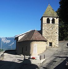
Sainte-Agnes (Isere)
| Sainte-Agnes | ||
|---|---|---|
|
|
||
| region | Auvergne-Rhône-Alpes | |
| Department | Isère | |
| Arrondissement | Grenoble | |
| Canton | Le Moyen Grésivaudan | |
| Community association | Le Grésivaudan | |
| Coordinates | 45 ° 14 ' N , 5 ° 55' E | |
| height | 270-2,978 m | |
| surface | 26.8 km 2 | |
| Residents | 563 (January 1, 2017) | |
| Population density | 21 inhabitants / km 2 | |
| Post Code | 38190 | |
| INSEE code | 38350 | |
| Website | http://www.sainte-agnes.fr/ | |
Sainte-Agnès is a French municipality with 563 inhabitants (as of January 1 2017) in the department of Isère in the region Auvergne Rhône-Alpes . It belongs to the Arrondissement of Grenoble and is part of the canton of Le Moyen Grésivaudan . The inhabitants are called Gareux .
geography
Sainte-Agnès is located about 18 kilometers northeast of Grenoble in the Grésivaudan countryside on the Belledonne mountain range . In the municipal area is the Grand Pic de Belledonne at 2977 meters. Sainte-Agnès is surrounded by the neighboring communities of Laval in the north, Allemond in the east and south-east, La Combe-de-Lancey and Saint-Mury-Monteymond in the south and Villard-Bonnot in the west and north-west.
Population development
| 1962 | 1968 | 1975 | 1982 | 1990 | 1999 | 2006 | 2013 | |
|---|---|---|---|---|---|---|---|---|
| 313 | 241 | 228 | 308 | 406 | 455 | 516 | 553 | |
| Sources: Cassini and INSEE | ||||||||
Attractions
- church
Web links
Commons : Sainte-Agnès - Collection of images, videos and audio files

