Charmes (Vosges)
| Charms | ||
|---|---|---|

|
|
|
| region | Grand Est | |
| Department | Vosges | |
| Arrondissement | Epinal | |
| Canton | Charmes (main town) | |
| Community association | Epinal | |
| Coordinates | 48 ° 22 ' N , 6 ° 18' E | |
| height | 258-385 m | |
| surface | 23.49 km 2 | |
| Residents | 4,689 (January 1, 2017) | |
| Population density | 200 inhabitants / km 2 | |
| Post Code | 88130 | |
| INSEE code | 88090 | |
| Website | www.ville-charmes.fr | |
 Town Hall Charmes (Hôtel de ville) |
||
Charmes is a French commune in the Vosges department of Region Grand Est . It belongs to the Arrondissement Épinal and the municipal association of Épinal .
geography
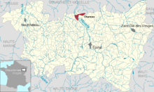
The small town of Charmes with 4689 inhabitants (January 1, 2017) is located on the Moselle between Épinal and Nancy .
The municipality of Charmes comprises a section of the Moselle valley, which runs in a south-east-north-west direction, a strip of hill country up to 1500 m wide to the left of the Moselle and to the right of the Moselle a portion of the Forêt de Charmes that extends far to the north-east and extends to the border of the Meurthe-et-Moselle department .
To the left of the Moselle, the Canal des Vosges runs parallel with three of its 93 locks in the Charmes area. The valley of the Moselle is characterized by numerous ponds and gravel pits, which were created, among other things, when the course of the river was straightened and some of which are used for fish farming. The Canal des Vosges crosses the Canal des Moulins twice , a very old junction from the Moselle to the mills near the old town, which were mentioned as early as the 11th century. The Moselle takes on the Ruisseau du Genet in the municipality of Charmes , and other small rivers run through the Forêt de Charmes . They flow into the northern neighboring municipality of Chamagne or over the Euron in the small town of Bayon into the Moselle.
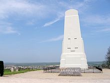
The hill country west of the Moselle rises up to 120 meters above the valley floor of the Moselle, with 385 meters above sea level, the highest point in the municipality is reached only 1000 meters southwest of the town center. The Monument de Lorraine, inaugurated in 1934, stands on this hill and forms a landmark that can be seen from afar. To the northeast of Charmes, the terrain gradually rises to 343 m above sea level. M. at. Characteristic of this area are the forests, which are divided into the Bois de Villacourt, Forêt de Charmes, Forêt de Ternes and Forêt de Fraize and comprise a contiguous forest area of around 50 km².
The locations in the Moselle valley are used for agriculture, on the slopes to the left of the Moselle there are scattered orchards. The originally round town center is west of the Moselle. From the core, settlement axes have formed along the Moselle and across the Moselle bridge to the eastern side of the river. They are surrounded by newer single-family housing estates and smaller industrial estates.
The district of Les Charmottes , a workers' settlement founded at the beginning of the 20th century, belongs to Charmes . To the north-west of the city are the Lotissement d'Activités de la Plaine and ZA Route de Nancy industrial areas, and the ZA Prés Charton and ZI de la Route de Chamagne industrial areas on the northern edge of the district to the right of the Moselle - the latter both with their own rail connections.
The neighboring communities of Charmes are Chamagne in the north, Saint-Germain , Loromontzey and Saint-Rémy-aux-Bois in the northeast, Essegney in the east, Vincey in the southeast, Ubexy and Brantigny in the southwest, Florémont in the west and Socourt in the northwest.
history
Today's small town goes back to a Gallo-Roman settlement on a Moselle crossing.
In the 11th century, the Counts of Toul built the fortified city with castle, walls and gates, which can still be seen in the streets of Charmes. The Moselle bridge and the mills on the Mühlenkanal (Canal des Moulins) were also included in the fortification.
In 1269, Charmes received city rights from the Touler Count Friedrich VI. (From 1251 the Counts of Toul were appointed by the Toul bishops to better manage their possessions). The 14th century was marked by famine, epidemics and robbery in Charmes and the surrounding area
Charmes was completely destroyed in 1475 during the dispute between the Lorraine Duke René II and the Burgundian Duke Charles the Bold over control of the region between Nancy and Épinal .
From 1486 the city was rebuilt. The market rights newly granted by René II helped. The Church of St. Nicholas (Église Saint-Nicolas) , which was built in 1493, dates from this period .
Despite the recurrence of epidemics, the 16th century was a time of economic expansion. The city was expanded towards the Moselle Bridge and along the Mill Canal (Canal des Moulins) (today's Rue du Patis ).
In 1633, during the Thirty Years' War , Duke Charles IV and Cardinal Richelieu signed a treaty in Charmes , which stipulated, among other things, that Nancy and the surrounding areas would come under the crown of France. Charles IV did not keep to the contract, which was unfavorable for him, and conquered Charmes with his troops. During a counterattack by Colonel Gassion , who later became Marshal of France , the city was cremated, the castle and city walls were razed, and the Moselle bridge was destroyed. The following years until the end of the 17th century brought more plundering, epidemics and famine, so that the city could hardly recover. A long period of peace and relative prosperity began in the 18th century. With the death of Stanislaus I in nearby Lunéville in 1766, Lorraine and with it Charmes fell to France in accordance with the treaty . The 19th and early 20th centuries were a period of enormous growth for Charmes. The connection to the railway network and the construction of the Canal des Vosges contributed to this, which promoted industrialization. At first, it was mainly textile companies that settled in Charmes, followed by tanneries. After the opening of the railway line ( Nancy -) Blainville-sur-l'Eau -Charmes- Épinal in 1857, new businesses emerged, including brickworks, sawmills and a cardboard factory. The KB brewery - for Kanterbräu - (Les Grandes Brasseries de Charmes) was founded in Charmes in 1864 . It was closed in 1973.
During the First World War , the battle of the Trouée de Charmes took place in the area . Charmes lost 200 dead in this war, at the end of the Second World War the city was destroyed by the retreating Germans. Liberation came by American troops on September 5, 1944. During the war 150 residents were deported to German camps, 100 of whom did not return alive. Among them was the then 76-year-old Mayor Henri Breton .
In 1947 work began on rebuilding the city, which had been destroyed again by war. This was achieved within five years thanks to the commitment of the mayor René Didierjean . Charmes was the first city in France to be completely rebuilt after the Second World War. The inauguration of the reconstructed city took place on July 20, 1952 in the presence of the then French President Vincent Auriol .
Population development
With 4689 inhabitants (January 1, 2017), Charmes is still one of the 20 most populous of the 507 municipalities in the Vosges department, despite the significant decline in population in the last quarter of the 20th century . The reason for the emigration was the decline of traditional industries, particularly the textile industry and brewing, from the mid-1970s. The trend was countered with the establishment of new industrial parks, the process is not yet complete.
| year | 1962 | 1968 | 1975 | 1982 | 1990 | 1999 | 2007 | 2017 | |
|---|---|---|---|---|---|---|---|---|---|
| Residents | 5177 | 5221 | 5702 | 5225 | 4721 | 4665 | 4560 | 4689 | |
| Sources: Cassini and INSEE | |||||||||
coat of arms
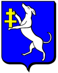
Blazon : "On a blue background an upright silver greyhound, holding a Lorraine cross in its paws."
The coat of arms originated from a seal from the 17th century. The current coat of arms appears a century later. It symbolizes the loyalty of the residents to the Duchy of Lorraine .
While the commune's internet presentation uses the cited coat of arms, a slightly different coat of arms is shown on the city hall (Hôtel de ville), which was built after the Second World War. Here the greyhound looks to the left (heraldically) and holds a shield with the Lorraine cross.
Attractions
- St. Nicholas Church (Eglise Saint-Nicolas) from 1493, Monument historique
- Chaldron House (La maison du Chaldron) at 19 rue Maurice Barrès , a building dating from 1537 where the Treaty of Charmes between Charles IV and Richelieu was signed in 1633 . The elevation, portal, courtyard and spiral staircase of the house are also classified as a monument historique. The house was completely renovated in 2009. Today the city's tourist office is located there.
- Notre-Dame-de-Grace chapel, built around 1490
- Remains of the city wall from the 15th century
- Former hydropower sawmill from the late 19th century
- Monument de Lorraine, a 13 meter high stele on the 385 m above sea level. M. highest point of the municipality commemorating the battle of the aisle of Charmes (Bataille de la trouée de Charmes ) from August 24th to 26th, 1914 at the beginning of the First World War (with the aisle or gap is a cut in the west of the Moselle The hill country that stretches from Charmes to Florémont ). The monument was created by the sculptor Joseph Rivière (1912–1961).
- Maurice Barrès' birthplace
Economy and Infrastructure
Charmes is a regional center that takes on the functions of medical care, education, administration and, last but not least, local transport for many surrounding communities. Numerous employees work in these areas. In the tourism sector, Charmes is represented by a hotel, several guest houses and a campsite. In addition, Charmes is an industrial location.
After the breakaway of traditional industries in Charmes (spinning mills, brick production, sawmills, breweries), medium-sized companies with a broader range of products have settled in new industrial areas. The manufacturing industry is represented by
- Collot et Compagnie: paper articles
- Patisfrance Puratos: canned food
- Fabrique de cercueils de l'Est , Sundo France and FCE Performance : cabinet makers
- SRE - Sté Routiere de l'Est: building materials
- United Springs: Manufacture of shock absorbers
- Constructions Soudées de l'Est: metal processing
- Precis Est Usinage: Electrical Engineering
There are also 76 retail outlets in the city.
The largest employer with around 550 employees is the French branch of the US company Trane , based in Piscataway Township , which produces vehicle equipment in Charmes (as part of the international conglomerate Ingersoll-Rand ).
education
Charmes is home to three kindergartens, two public primary schools, a private school, a grammar school and a vocational school.
Transport links
Eight highways meet in a star shape in Charmes: four on either side of the Moselle . The two-lane national road 57 from Nancy to Épinal leads with a junction through the municipality of Charmes. Charmes train station is on the Nancy-Épinal- Remiremont railway line, which largely follows the Moselle valley and is operated by the TER Lorraine company.
partnership
A partnership has existed since 1967 with the southern Belgian municipality of Bertrix .
Personalities
- Maurice Barrès , actually Auguste-Maurice Barrès (born August 19, 1862 in Charmes, † December 4, 1923 in Neuilly-sur-Seine ), novelist, journalist and politician
- Joseph-François Malgaigne (1806–1865), surgeon, medical writer, editor and university professor
- Charles Stanislas Marion (1758–1812), infantry general
See also
supporting documents
- ↑ Data partly from annuaire-mairie.fr. Retrieved November 21, 2010 (French).
- ^ History of the city of Charmes. (No longer available online.) Archived from the original on May 7, 2012 ; Retrieved November 21, 2010 (French). Info: The archive link was inserted automatically and has not yet been checked. Please check the original and archive link according to the instructions and then remove this notice.
- ↑ Charmes on cassini.ehess.fr
- ↑ Charmes on insee.fr
- ↑ Description of the coat of arms on genealogie-lorraine.fr. Retrieved November 21, 2010 (French).
- ↑ Entry on culture.gouv.fr. Retrieved November 21, 2010 (French).
- ↑ Entry on culture.gouv.fr. Retrieved November 21, 2010 (French).
- ↑ Retailers on annuaire-mairie.fr (French)
- ↑ Manufacturing in Charmes on vosges.com. (No longer available online.) Formerly in the original ; Retrieved November 21, 2010 (French). ( Page no longer available , search in web archives ) Info: The link was automatically marked as defective. Please check the link according to the instructions and then remove this notice.
- ↑ ville-charmes.fr/vue d'ensemble. (No longer available online.) Archived from the original on December 10, 2010 ; Retrieved November 21, 2010 (French). Info: The archive link was inserted automatically and has not yet been checked. Please check the original and archive link according to the instructions and then remove this notice.


