
Palatinate Forest
| Palatinate Forest as the northern part of the Palatinate Forest-Northern Vosges natural area |
|
|---|---|
 Palatinate Forest-Northern Vosges natural area |
|
| Highest peak | Kalmit ( 672.6 m above sea level ) |
| location | Rhineland-Palatinate ( Germany ), Bas-Rhin and Moselle ( France ) |
| part of | Northern French layer level country |
| Classification according to | Handbook of the natural structure of Germany / concept of the working group landscape names |
| Coordinates | 49 ° 17 ' N , 7 ° 53' E |
| Type | Low mountain range |
| rock | Mainly formations of the lower, middle and upper red sandstone ; in the southeastern part of the rocks of the Rotliegend and the Zechstein |
| Age of the rock | Buntsandstein rock unit: about 251–243 million years; The rock unit of the Zechstein: about 256-251 million years |
| surface | Depending on the definition of the limits 1,589.4 or 1,771 km² |
| particularities | Haardt mountain range (eastern edge) and Wasgau (southern part) |
The low mountain range Palatinate Forest (as the official spelling, often also Palatinate Forest , in natural spatial structures also Haardt Mountains ) in the state of Rhineland-Palatinate is the largest contiguous forest area in Germany. Its extension is, depending on the natural delimitation, 1589.4 km² corresponding to 158,940 hectares or 1771 km² corresponding to 177,100 hectares, with 82 to 90 percent of the area being covered by forest. It thus takes up a good third of the entire Palatinate , whose central landscape it represents and from which it takes its name. The southern continuation of the natural area on French soil, called the Northern Vosges (French: Vosges du Nord ) here, is only 30 percent smaller . It stretches to the Zaberner Steige and is there replaced by the Vosges in the narrower sense.
The Palatinate Forest Nature Park, which is slightly larger with 179,800 hectares , also includes the stretch of land between Haardtrand and the German Wine Route in the east and the valleys of Eckbach and Eisbach in the northeast. The Palatinate Forest-Vosges du Nord biosphere reserve , which also includes the French continuation, has an area of 310,500 hectares.
Basic geographic structure

The Palatinate Forest, together with the Vosges , which join south of the French border without any morphological separation, is part of a unified low mountain range with a total area of around 8,000 km², which extends from the Börrstadt valley ( Winnweiler - Börrstadt - Göllheim line ) to the Burgundian gate ( Belfort line - Ronchamp - Lure ) and forms the western boundary of the Upper Rhine Plain . This landscape is in turn the easternmost part of the very extensive northern French layered plain , which takes up large parts of the Palatinate and Saarland on German soil, with older (e.g. at Donnersberg ) and younger rock layers ( shell limestone , e.g. Westrich plateau ).
structure
The Palatinate Forest is within the Palatinate-Saarland layer level country ( Greater Region 2nd Order) a natural spatial region of the 3rd order, which extends south to the Zaberner Steige , i.e. far into French territory, where the ridge continues in the Vosges . Regardless of this, because of the national border, the French southern part of the natural area is often included in the northern Vosges.
The most important breakdowns of the Buntsandsteingebirge were made in the 1950s and 1960s in the handbook of the natural spatial structure of Germany along with individual sheets 1: 200,000 by the Federal Institute for Regional Studies. Meanwhile, landscape names deviating from this structure have prevailed.
The most important partial landscapes are listed below with a map, whereby only known landscapes are named and only more significant landscape boundaries are drawn.

-
Palatinate Forest
-
Lower Palatinate Forest (Northern Palatinate Forest)
- Otterberg Forest (up to 380 m)
- ( Sembacher plates )
- Stump forest (only near the southern seam over 400 m)
- Queitersberg ( Quaidersberg, Quaitersberg ; 394.0 m); Eastern framing of Kaiserslautern
-
Middle Palatinate Forest (only significantly separated partial landscapes highlighted)
- Diemersteiner Wald (up to 450 m)
- Leininger Sporn (up to 516 m)
- High Palatinate Forest (main plateau of the Frankenweide ; up to 610 m)
- Haardt (up to 672.6 m)
-
Wasgau
- Western Wasgau (up to 513 m)
-
Dahn-Annweiler rock country
- Stürzelbronn-Schönauer Felsenland (up to 581 m)
-
Dahner Felsenland (up to 577 m)
- Dahner Felsenland in the narrower sense
- Annweiler Felsenland
- Annweiler-Albersweiler-Ausraum (" Trifelsland ")
-
Eastern Wasgau
- Upper Mundat Forest (up to 562 m)
- Hochwald (up to 529 m)
- Lembacher Graben
- Southern Wasgau (up to 526 m; drainage to the Moder )
-
Lower Palatinate Forest (Northern Palatinate Forest)
Limits

While the Palatinate Forest is comparatively sharply delimited to the north and east, the transition to neighboring landscapes to the west and south is rather fluid.
To the north, the North Palatinate Bergland connects to the Palatinate Forest with the Donnersberg ( 686.5 m ). This is where the red sandstone formations typical of the Palatinate Forest end, which are made up of other types of rock, e.g. B. be replaced by rocks of the Rotliegend . This results in a clear geomorphological demarcation of the two landscape areas, which runs roughly on a line from Eisenberg, Göllheim, Börrstadt to Otterberg near Kaiserslautern .
The hill country between Haardt and the Upper Rhine Plain, where the Palatinate wines are grown , is known as the wine route . The German Wine Route runs through this hill zone .
The Kaiserslauter Depression , which runs in a west-south-west-east-north-east direction, extends into the northwest of the Palatinate Forest , to which, in particular, west of Kaiserslautern, in the moorland of the Landstuhler Bruch , the southern neighboring landscapes fall in a distinct layer .
To the west of the Großer Hausberg , the Westrich plateau replaces the Palatinate Forest on the sharp southern border of the Landstuhler Bruch in a comparatively smooth transition. It reaches comparable heights in the transition area, but has a significantly different relief than the shell limestone plateau and is no longer forested throughout. As a western border, it not only extends around the Palatinate Forest, but also further south around the Vosges in the narrower sense. Approximately from Lemberg in Lorraine, it also forms the watershed between the Moselle and the Upper Rhine; the south of the region drains completely through the system of the Moder to the Upper Rhine.
To the south, the narrow Zaberner Steige forms a border between the Palatinate Forest, which continues with the Vosges du Nord ( Northern Vosges in German ) to France, and the “actual” Vosges . Geomorphologically and geologically, this dividing line is less sharply defined than it is on the right bank of the Rhine, where the Odenwald and Black Forest are clearly separated from each other by the lowland of the Kraichgau . Only the Burgundian Gate on the other side of the Vosges does a comparable orographically clear border on the left bank of the Rhine.
history
Surname
The name Palatinate Forest was not coined until 1843, when the Palatinate was part of the Kingdom of Bavaria, in the centrally located municipality of Johanniskreuz at a conference of foresters led by Ministerialrat Albert von Schultze , who used it to designate the forests in the red sandstone area of the Palatinate. The name became more widespread when the Palatinate Forest Association (PWV) was founded in 1902 , with Fritz Claus , one of the pioneers of the PWV, campaigning intensively for the new name. A scientifically founded, more precise definition of the Palatinate Forest as an independent natural spatial unit was made in 1911 by Daniel Häberle , a Palatinate geographer and local researcher.
When expanding the linguistic historical perspective, it is noticeable that before 1850 there was no cross-spatial name for the Palatinate red sandstone mountains. Not geographical, but territorial-historical factors determined the perception at that time. In contrast, the Celts and Romans understood the entire mountains on the left bank of the Rhine as a spatial unit, i.e. no separation was made between the various parts of the mountains, today's Palatinate Forest and the Vosges . The mountain range was named after the Celtic forest god Vosegus and is attested in numerous Roman manuscripts as “silva vosegus” or “mons vosegus”. From this language root, the names Vosges for the French and Wasgen , Was (i) genwald , later also Wasgau for the German-speaking area, developed in the course of the Middle Ages .
While the term Wasgen stood for the entire mountains on the left bank of the Rhine for a long time, at the beginning of the 20th century it was gradually narrowed to the Alsace-Lorraine part of the red sandstone mountains (Vosges) in the public consciousness as well as in the scientific discussion the name Palatinate Forest became more and more natural for the Palatinate part . As a result, the Palatinate Forest and the Vosges were defined as separate, different landscapes. However, in the last few decades, within the framework of European unification ( Schengen Agreement ), there has been an increasing tendency to regard the entire mountain complex as a geographical unit again. As evidence of this changed attitude, u. a. The 1998 establishment of the first cross-border biosphere reserve Palatinate Forest-Vosges du Nord can be seen.
Settlement history
Little human traces (up to 10th century)
While since the Neolithic (5500-4500 BC) and especially at the time of the Celts (800-10 BC) and Romans (10 BC to 450 AD) in favored regions of today's Palatinate can prove various settlement activities, the left bank of the Rhine was practically deserted and covered by dense primeval forests until the end of the migration (around 600).
Monasteries, colonization and development (7th to 13th centuries)

After the Franks, when they conquered the land in the early Middle Ages (7th to 10th centuries), only pushed as far as the edges of what is now the Palatinate Forest, increasing population pressure in the High Middle Ages (10th to 13th centuries) led, above all, to initiatives by the nobility and the church , e.g. B. by founding monasteries such as the Cistercian monasteries Otterberg (1144) and Eusserthal (1148) to colonize and develop the low mountain range. Areas that could be used for agriculture were cleared and settled permanently. This development reached its climax in the era of the Salians (10th to 12th centuries) and Staufer (12th and 13th centuries), in which the region with the Trifels castle and other surrounding castles was at times the center of power of the empire at that time .
Desolation, overexploitation and impoverishment (14th to 18th centuries)
This development came to an end in the late Middle Ages (13th to 15th centuries) and the early modern times (16th to 18th centuries), as epidemics (e.g. plague ) and famine led to a significant decline in the population and the total number of Settlements fell sharply (development of desertification ), for which, in addition to wars, mainly economic reasons were responsible. As areas were cleared during the colonization of the mountain often the result of nutrient-poor sandy soils for productive agriculture were actually unsuitable and their management by overuse and overexploitation be set after a short time back had. The forest was also not used for the production of firewood and construction wood according to the principles of sustainability . On the one hand, litter use ( leaves as litter for the cattle) and forest pastures damaged the soil and forest, on the other hand the production of iron , glass and potash , which required a lot of wood, led to overexploitation and devastation of the forest over centuries and thus to further impoverishment the population. Professions that the forest itself offered, such as As a result, woodcutters , charcoal burners , rafters , resin burners (pitch boilers) and ash burners also only made a meager income possible.
Immigration, renewed impoverishment, first commuters (late 18th to early 20th century)

After the large population losses during the Thirty Years' War , the population was restored and stabilized from the end of the 17th century, initially through the immigration of settlers from Tyrol and Swabia or through the admission of religious refugees from Switzerland, France and Holland ( Huguenots , Mennonites ) then from the end of the 18th century a. a. The improved construction of the farmsteads ( Franconian farmstead ) and the expansion of the village structures ( clustered villages ) resulted in increased population growth. However, this development meant that the resources of the low mountain range were quickly exhausted and overpopulation and poverty led to increased emigration to the New World , especially in the 19th century . In addition to the modest iron extraction and processing, the work in the forest and the operation of paper mills , the emerging shoe industry in the Pirmasens area was the only source of income for the population. Here, the construction of the railway in the second half of the 19th century ( Ludwigsbahn and Landau – Zweibrücken railway ) meant a certain improvement in living conditions, as it was now possible to commute to cities outside the Palatinate Forest and find a job in one of the newly emerging ones Find industrial companies (e.g. BASF Ludwigshafen ).
Deindustrialization and Tourism (20th and 21st Century)

In the 20th century, the general structural change also affected the Palatinate Forest region, which was increasingly integrated into overarching economic and transport systems. With the appropriate infrastructure (e.g. transport links), remote forest farming villages were transformed into municipalities with a service character , whereby the professional activity is often not carried out on site, but in more distant middle and regional centers (e.g. Ludwigshafen, Kaiserslautern).
In contrast, industrial companies close to home are rarer in the mountains or have been dismantled, as can be seen from the example of the shoe industry. After its heyday in the 1950s and 1960s, globalization processes (relocation of production abroad) led to the almost complete collapse of this branch of industry, which, in the 1980s and 1990s in particular, caused increased unemployment and emigration tendencies . In addition, the profound demographic changes of the last few decades are creating further structural problems of which remote communities in sparsely populated areas are particularly affected due to population decline, aging and migration.
At the same time, however, in the second half of the 20th century, the forest mountains became increasingly important as a recreational and leisure area of special ecological importance. This is reflected in various tourist concepts and activities that open up additional work and income opportunities for the local population and counteract the structural changes described above.
Nature park and biosphere reserve
In the past, the Palatinate Forest was seen mainly as a source of raw material and energy supply, today, in addition to its recreational and leisure function, its ecological importance as a “particularly protected landscape” has come to the fore. This change in attitude took a. its visible expression also in the establishment of the Palatinate Forest Nature Park and later the Palatinate Forest-Vosges du Nord Biosphere Reserve .
Natural park

The Palatinate Forest Nature Park was created in 1958 as the third nature park in Germany. According to the demands of the originator of the nature park idea , Alfred Toepfer , the Palatinate Forest should become a recreation and exercise space for stressed people sitting down from the cities on the Rhine plain, which at that time suffered heavily from air pollution. The expansion program included 95 parking spaces, 13 tent sites, seven observation towers and five outdoor pools.
In fact, 62 forest parking spaces were created in the first seven years, as well as 530 benches and just as many waste paper bins. 370 kilometers of hiking trails have been expanded or newly created and 45 circular trails have been marked. The Palatinate Forest Association (PWV) took over the management of the nature park. The 20 open shelters in log cabin construction that were also built were named after the then managing director of the Palatinate Forest Association, Ludwig Fischer, Fischer huts .
In the mid-1960s, the PWV came to the conclusion that the work could no longer be done by volunteers, and the management of the nature park was handed over to the Palatinate district government . By 1974, the equivalent of 3.7 million euros had been spent on improving recreational opportunities.
Around 1975 the expansion of the recreational area was considered complete and the focus was on the care of biotopes and the landscape. Increasingly, they wanted to also incurred in war, reparations and crisis in many places coniferous forest - monocultures by a species-rich, site-specific mixed forest replace.
The Palatinate Forest Nature Park Association was founded on July 20, 1982 as the supporting organization . The members of the association are the districts and urban districts involved in the nature park, as well as the Pfalz district association as well as various hiking, sports clubs and environmental associations. Many social forces are involved in the nature park work, which is intended to ensure independence from individual specialist and regional interests. The aim of the association is to uniformly develop the nature park and the biosphere reserve of the same name and to maintain and maintain its uniqueness and beauty as well as its supraregional recreational value. The office of the association has been based in Lambrecht since 1997 .
The sponsoring association Naturpark Pfälzerwald e. V. was dissolved on December 31, 2013 and its tasks were transferred to the Palatinate District Association . Since January 1, 2014, he has been solely responsible for the Palatinate Forest Nature Park. In the course of the restructuring, a committee was formed to deal specifically with the needs of the nature park. It is made up of 20 members, and in addition to the representatives of political organizations there are also five members who were previously active on the nature park board.
Biosphere reserve


The Palatinate Forest Nature Park was recognized by UNESCO as a biosphere reserve in 1992 , and in 1998 it became part of Germany's first cross-border biosphere reserve, namely the Palatinate Forest-Vosges du Nord biosphere reserve. It was the twelfth of (as of 2009) 15 German biosphere reserves. These are areas that are of particular importance for the global preservation of biological diversity and in which ecological aspects, sustainable management, environmental education and environmental research are combined in the best possible way.
In 2007, the state of Rhineland-Palatinate issued a legal ordinance with which the UNESCO guidelines for the design of biosphere reserves are to be implemented specifically for the Palatinate Forest Nature Park. The focus is on a zoning concept that provides three zones with different goals and protective functions:
- Core zones
- There, a "largely unaffected sequence of natural processes", i.e. complete protection of typical ecosystems, is to be guaranteed.
- Care zones
- In maintenance zones, the focus is on “nature-friendly farming methods” that maintain the character of the landscape. They should complement and network the core zones.
- Development zones
- The main focus is on the promotion of "model projects for sustainability". B. can include the further development of concepts of sustainable tourism or the environmentally friendly production of regional products.
The quiet zones also named in the law are intended to guarantee “relaxation in silence”, but are not part of the UNESCO guidelines for biosphere reserves. Rather, the concept comes from the old protected area ordinance for the Palatinate Forest Nature Park (1984) and therefore overlaps with the three other zones.
Core, maintenance and development zones are representatively distributed over the area of the biosphere reserve. In this context, u. a. 16 core zones are defined, which together cover around 2.3 percent of the area, with the headwaters of the Wieslauter with its mixed forest-like beech, oak and pine stands as the largest core zone (2296 ha) of the biosphere reserve.
geology
The Palatinate Forest is primarily characterized by the rock unit of the Buntsandstein and underlying formations of the Zechstein , whereby the tectonic storage of these types of rock and their erosion have led to the current surface form of the low mountain range.
Development history
Formation of the red sandstone
In the Permian Age (about 296-251 million years ago), the first sandstone formations about 100 meters thick were deposited in the area of today's Palatinate Forest, whereby the rock units of the Rotliegend and the Zechstein (about 256-251 million years) are of particular importance. At the beginning of the Germanic Triassic , d. H. From the Lower Triassic to the beginning of the Central Triassic (around 251–243 million years ago) the climate was desert-like, so that further sand deposits resulted in rock layers up to 500 meters thick. Among other things, the admixture of iron oxide resulted in different colorations of the rock package - therefore red sandstone - and depending on the type and binding of the material (clayey sandstone in contrast to silicified quartz sandstone), rock layers of different hardness were formed. The subgroups of the lower, middle and upper red sandstone were created. These red sandstone formations were in the subsequent sections of the shell limestone (243–235 million years ago) and Keupers (234–200 million years ago), and also during the Jurassic (200–142 million years ago) and Cretaceous (142–65 million years ago) Years) covered by different types of sediments.
Storage of the red sandstone

At the beginning of the Modern Era ( Cenozoic ), the formation of the Alps in the Paleogene (65–23.8 million years ago) led to considerable tensions in the earth's crust , which caused the earth's mantle and crust to bulge in its northern foreland . In the apex of this vault there was considerable tensile stress, so that the rock layers were stretched and about 35 million years ago deep fractures and depressions occurred in the earth's crust ( passive rifting ). At the same time, the edges of the ditch of the newly created lowland were raised, in the case of the Palatinate Forest by around 1000 meters.
These processes, which still continue today, had and still have four important effects on today's landscape of the low mountain range:
- Removal of around 800 meters of overburden ( Dogger , Lias , Keuper, Muschelkalk) and thus exposure of the red sandstone
- Inclination of the layers of red sandstone
- Development of thresholds and hollows
- Breaking of the red sandstone into individual clods; Formation of faults
Development of today's surface design
In the later Paleogene (34–23.8 million years ago) and Neogene (23.8–2.8 million years ago) as well as in the Quaternary (2.8–0.01 million years ago) erosion processes were more in the foreground, Above all, the weathering and erosion processes during the various cold and warm periods determined the surface shape of the Palatinate Forest today. Characteristic here are a deeply cut valley system, especially in its northern and central part, diverse mountain shapes and bizarre rock formations.
Structure or structure

Rocks of the basement
Gneiss and slate form the mountain base of today's Palatinate Forest, but are mostly covered by younger rock formations. They only come to the surface in a few places on the eastern edge of the mountains.
Formations of the Rotliegend and Zechstein
These rock layers cover the basement and, in addition to sandstone, consist of slate and marl . They have an overall softer consistency and therefore form wide valleys and larger planarized areas in the Lower Palatinate Forest ( stump forest ) as well as in its south-eastern part. The southern Palatinate sandstone formations of the Zechstein are divided into four layers, which have a total thickness of about 80 to 100 meters.
Layers of red sandstone
The red sandstone rock unit is divided into three layers:

- Lower red sandstone
- It represents the typical rock of the Palatinate Forest and covers large parts of the low mountain range with a thickness of 280 to 380 meters. The sandstones contain a lot of quartz and little feldspar and mica , so that they weather into sandy, nutrient-poor soils that are hardly used agriculturally to this day. Overall, a distinction is made between three sub-layers (Trifels, Rehberg and Schlossberg layers), in which different rock zones of different thickness are combined.
- Medium red sandstone
- Here, too, different rock zones with a thickness of around 80 to 100 meters can be identified. Particularly striking are the Karlstal layers, which often come to the surface as silicified boulders, as well as the adjoining upper rock zone and main conglomerate , which also consist of silicified coarse sandstones and rubble. This formation is closed off by the “violet boundary layer”, which is mainly composed of fine, mica-rich sediments .
- Upper red sandstone
- Intermediate layers and Voltziensandstein together form the upper red sandstone with a thickness of about one hundred meters. In contrast to the lower and middle red sandstone, these layers contain more mica , carbonates and clay minerals and therefore weather into more nutrient-rich soils, which are used for agriculture on cleared islands in the western Palatinate Forest ( Holzland ).
Surface shape (geomorphology)
Landscape character
Weathering and erosion in the rock layers of different hardness in the Palatinate Forest led to a diverse low mountain range with a dense, deeply cut valley system and diverse mountain shapes. The hard and more resistant rocks of the lower and middle red sandstone form a layered relief , the steps of which characterize the landscape especially in the north and east, while in the south-eastern Palatinate Forest rather isolated mountain forms dominate, which are separated by planed areas.
The Palatinate Forest as a heavily divided low mountain range with diverse mountain shapes and dense forest: panoramic view from the Rehberg (tower) to the Trifels in north direction

Mountains and rocks
General characteristics

In the red sandstone mountains, depending on the rock layer, a variety of different mountain forms can be observed. Typical of the Lower and Middle Palatinate Forest are towering mountain blocks and elongated trapezoidal ridges with often rocky summits (e.g. Kesselberg , 661.8 m ), while in the western part of the Mittelgebirge mountain formations similar to high plateaus with cleared areas predominate. In the south-eastern Palatinate Forest, on the other hand, sediments from the Rotliegend and the Zechstein (leveling areas), as well as parts of particularly resistant Trifels and Rehberg layers (Kegelbergs) characterize the landscape.
Weathering and erosion over millions of years have resulted in a multitude of bizarre rock formations, depending on the hardness of the sandstone, e.g. B. rock towers , rock walls , rock walls and boulders created. Rock openings, peat rocks and table rocks ( devil's table ) have also emerged through small-scale weathering of layers of different hardness . On the almost two kilometer long rocky reef of the Altschlossfelsen , crevices , overhangs and weathering of honeycombs can also be observed. Rock seas and block fields, on the other hand, are more likely to be found in the Middle Palatinate Forest.
More detailed topographical consideration

In this context, it becomes clear that the Middle Palatinate Forest, mainly in its eastern part, is also home to the highest peaks of the mountains.
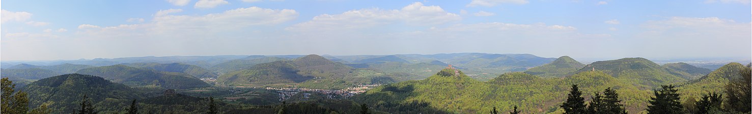
Here, in a contiguous range of mountains, various mountains exceed the 600-meter mark, with the Große Kalmit at 672.6 m also being the highest point in the entire Palatinate Forest. The ridge continues from the Steigerkopf (also Schänzel ) at a height of about 500 m westwards to the Frankenweide around Eschkopf ( 609.9 m ) and Weißenberg ( 609.9 m ). This massif extends from Hochspeyer via Johanniskreuz to Hauenstein . Especially in the middle area between Johanniskreuz and Hermersbergerhof it is more of a high plateau that is bordered by deeply cut valleys. This high plateau also continues to the west at a height of around 500 m and gradually sinks to 400 m. It is cut through by Schwarzbach and Moosalb . To the southwest, ridges run between the valleys of the Merzalbe and the source rivers of the Wieslauter . It is therefore possible to hike from Neustadt an der Weinstrasse to Leimen or Kaiserslautern-Mölschbach without going below the elevation line of 450 m .
North of the Hochspeyerbach / Speyerbach line , the highest peaks are the 570.8 m high Drachenfels and the Hohe Stoppelkopf ( Stoppelkopf ; 566.2 m ). In the triangle formed by the Isenach to the north and the German Wine Route to the east, there are further elevations over 500 m high. The most striking are the northern Neustadt local mountain, the Weinbiet ( 554 m ) and the Eckkopf ( 516 m ) near Deidesheim . To the north of the Isenach, only the Rahnfels ( 516.5 m ) exceeds the 500 m height line. In the further course to the north, the height decreases to 400 to 300 m.

To the south of the Queich, due to the somewhat different geological conditions (see the chapter on landscape character ), larger planarization areas and rather isolated mountain forms (cone mountains) can be observed, which reach an average of 450 m. The highest elevations in the German part of Wasgau are the Rehberg ( 576.8 m ) near Annweiler, the castle hill of the Wegelnburg ruins ( 570.9 m ) near Nothweiler , followed by the Hohen Derst ( 560.5 m ) west of Bad Bergzabern and the Great Eyberg ( 513 m ) southwest of Dahn . Hohe List ( 475.8 m ) and Erlenkopf ( 472.1 m ) near Eppenbrunn are the highest elevations in the southwest.
Table overview
The category structure of the list is based on the concept of the natural spatial structure of the Palatinate Forest . The main elevations of the mountains were assigned to the corresponding sub-landscapes and sorted according to the height in meters (m) above mean sea level (NHN). For mountains that are less well known or without a separate Wikipedia article, the nearest municipality is given as a guide.
| Lower or Northern Palatinate Forest |
Middle Palatinate Forest | Southern Palatinate Forest or Wasgau, German part |
||||
|---|---|---|---|---|---|---|
| Stump forest | Otterberg Forest | Haardt | Frankenweide | other areas | Wasgau rock country |
other areas |
|
Leuchtenberg (491.5 m) (south of Carlsberg ) |
Heidenkopf (419.6 m) (south of Heiligenmoschel ) |
Kalmit (672.6 m) |
Mosisberg (approx. 610 m) |
Schafkopf (617.8 m) |
Rehberg (576.8 m) |
Hohe Derst (560.5 m) (west of Dörrenbach ) |
|
Steinkopf (484.0 m) (south of Carlsberg) |
Andreasberg (401.0 m) (south of Heiligenmoschel) |
Kesselberg (661.8 m) |
Weißenberg (609.9 m) |
Steigerkopf (Schänzel) (613.6 m) |
Wegelnburg (570.9 m) |
Bobenthaler button (533.9 m) |
|
Kieskautberg (460.6 m) (south of Carlsberg) |
Eulenkopf (399.6 m) (southwest of Potzbach ) |
Roßberg (637.0 m) |
Eschkopf (608.3 m) |
Morschenberg (608.3 m) (west of Sankt Martin ) |
Hohenberg (551.9 m) |
Schletterberg (approx. 523 m) (north of Waldhambach ) |
| Heidenberg (446.2 m) (southeast of Alsenborn ) |
Queitersberg (394.0 m) |
Hochberg (635.3 m) |
Hydrangea (606.2 m) |
Rotsohlberg (607.1 m) (west of Sankt Martin) |
Förlenberg (533.1 m) (west of Leinsweiler ) |
Krummer Ellenbogen (514.7 m) (east of Niederschlettenbach ) |
|
Hohe Bühl (443.6 m) (west of Carlsberg) |
Oven (389.2 m) (northwest of Drehentalerhof) |
Hohe Loog (618.7 m) |
Schindhübel (approx. 571 m) |
Hermeskopf (581.3 m) (north of Ramberg ) |
Schlüsselfelsen (524.0 m) (east of Schönau ) |
Great Eyberg (513.0 m) |
|
Schorlenberg (402.0 m) (east of Alsenborn) |
Bruchberg (388.6 m) (north of Otterberg ) |
Blättersberg (613.2 m) |
Bloskülb (570.2 m) |
Drachenfels (571 m) |
Maimont (515.0 m) (south of Fischbach ) |
Treutelsberg (503.7 m) (west of Klingenmünster ) |
|
Bocksrück (400.6 m) (west of Sippersfeld ) |
Gersweilerkopf (378.9 m) (east of Erlenbach ) |
Teufelsberg (597.6 m) |
Blosenberg (558.9 m) (west of Hofstätten ) |
Großer Adelberg (567.4 m) (north of Annweiler ) |
Wetterberg (512.7 m) (west of Leinsweiler) |
Großer Mückenkopf (484.9 m) (north of Fischbach) |
|
Eiskopf (397.0 m) (east of Alsenborn) |
Großer Ohligkopf (377.6 m) (east of Otterberg) |
Orensberg (581.2 m) |
Katzenkopf (553.3 m) (north of Wilgartswiesen ) |
High stubble head (566.2 m) |
Kappelstein (498.0 m) (south of Nothweiler ) |
Stäffelsberg (480.8 m) (west of Dörrenbach) |
|
Klauserkopf (384.0 m) (north of Ramsen ) |
Einsiedlerberg (370.0 m) (northeast of Drehentalerhof) |
Weinbiet (554.0 m) |
Staufelkopf (552.0 m) (northwest of Wilgartswiesen) |
Almersberg (564.1 m) (north of Rinnthal ) |
Jüngstberg (491.1 m) (east of Wieslautern ) |
Hohe List (475.8 m) (east of Eppenbrunn ) |
|
Pfrimmerberg (377.1 m) (east of Sippersfeld) |
Sulzberg (368.9 m) (east of Erlenbach) |
Corner head (516.0 m) |
Spitz Boll (540.1 m) (southwest of Hermersbergerhof ) |
Rahnfels (516.5 m) |
Wolfshorn (476.7 m) (west of Schwanheim ) |
Erlenkopf (472.1 m) (south of Eppenbrunn) |
Valleys and waters
General characteristics

Characteristic of the lower and middle red sandstone are narrow notch valleys cut deep into the rock package with narrow valley bottoms and steep side slopes. They are the typical valley shape in the Middle Palatinate Forest, while in its southern and northern parts box valleys with a wider valley floor predominate. In the south-western Palatinate Forest, so-called Woog valleys can be found, in which the valley floor is particularly wide and which are therefore particularly suitable for creating ponds (= Wooge), ponds and small lakes (see below).
Water balance
A typical feature of the Palatinate Forest is its abundance of water, which has led to a differentiated system of streams, small rivers and wetlands (see below). Seep The sandy soils caused by weathering are very permeable to water, so that rain water quickly in the ground, as ground water through fissures and columns can be passed of the sandstone packet ( " gap ground water line "). This groundwater is then stored in various rock zones, especially in the trifle layers of the lower red sandstone and in a rock zone of the Karlstalschichten (middle red sandstone). Layers of clayey sandstones form source horizons . B. is released back to the surface in layer sources . Since the sandstone is very poor in minerals and the groundwater therefore only has low solution content, the water is in the low hardness range (soft) and is slightly acidic (low pH value).
Still waters

The conditions described above also lead to a large number of wetlands , which are often tied to spring horizons and in which the groundwater returns to the surface. Here, Moore , fens and lakes called Wooge , typical of the Palatinate Forest, although most Wooge are not of natural origin. Rather, they were created artificially by damming streams and served as collection points and water reservoirs for the drift of wood, as mill ponds or fish ponds. In terms of area, all of the lakes and wooges in the Palatinate Forest are insignificant. The best known are the Gelterswoog on the northwestern edge, the Clausensee in the southwest and the Eiswoog in the northeast.
Flowing waters
The Palatinate Forest is drained by four large drainage systems and also by smaller systems or individual streams. The four major systems are the Speyerbach , the Queich , the Lauter (on the upper reaches of Wieslauter ) and the Schwarzbach . While the first three flow directly to the Rhine, the water of the Schwarzbach flows indirectly to it via Blies , Saar and Mosel . Smaller drainage systems are z. B. the Saarbach or the Isenach , which have only a small number of tributaries. Most of the small outflows that drain the Palatinate Forest directly into the Rhine plain flow over extensive rift systems to the nearest northern river. The Speyerbach absorbs the water from the Hainbach , Modenbach and Krebbach.

The following river systems drain the Palatinate Forest clockwise, starting in the west (the total catchment areas in brackets):
- Schwarzbach (1151.5 km²)
- (Wald-) Lauter (275.6 km²)
- Alsenz (327.7 km²)
- Pfrimm (246.4 km²)
- Eisbach / Eckbach
- Isenach (294.9 km²)
-
Speyerbach (595.8 km²)
- Hochspeyerbach (119.3 km²)
- Speyerbach
- Modenbach (84.1 km²)
- Queich (271.2 km²)
- Michelsbach / Otterbach
-
Lauter (382.3 km²)
- Wieslauter
- Salzbach (Lauter) (52.4 km²)
- Saarbach (805.5 km²)
- Moder (1720 km² - river area extends on the other side to the state border)
The river system of the Schwarzbach is the only one in the Palatinate Forest that drains to the Moselle . Waldlauter and Alsenz drain to the Nahe (Lauter over Glan ), all of the systems listed below drain from north to south, directly to the Rhine.
The Palatine main watershed and the watershed between the Rhine (Upper Rhine) and Moselle (Middle Rhine) achieved by the Sickingerhöhe coming to the west, the north of the Palatinate Forest just west to the south of the central city of Kaiserslautern and turns from there to the southeast. From Johanniskreuz it first runs southwards - passing Eschkopf and Mosisberg to the west - and then turns to the southwest in the area of the Hortenkopf ; in this direction it continues via Burg Gräfenstein , Lemberg and Forsthaus Hohe List , to finally leave German territory at Erlenkopf southeast of Eppenbrunn (see adjacent map). It is formed by different, interconnected ridges (ridge watershed) and separates the Schwarzbach river system from all other drainage systems mentioned here.
particularities
Haardtsandstein
On the eastern edge of the mountains, light yellow, bleached sandstone can be found in some regions, which used to be quarries near Bad Bergzabern , Frankweiler and Hambach or is still mined, as is the case with Leistadt and Haardt on the Weinstrasse . The reddish iron oxide was carried away by hot solutions that rose in the fracture zone between the Palatinate Forest and the Rheingraben and the sandstone was discolored as a result.
Earlier volcanic activity on the Pechsteinkopf
53 million years ago there was tension in the earth's crust and mantle in the area of what would later become the Upper Rhine Rift (see also storage of the red sandstone ), so that magma could rise upwards and escape along cracks . In the first explosive phase , a funnel formed which filled with loose volcanic material . Subsequently, in a second phase, magma penetrated upwards in a calm and non-explosive form, so that dark, upright or inclined basalt columns formed in the volcano's extraction slot. These rock deposits can now be clearly seen on the site of a disused hard quarry.
climate
General
Viewed over a large area, the Palatinate Forest, like the rest of Central Europe, lies in the temperate climatic zone in the transition area between Atlantic and continental climate types , whereby these general conditions are strongly influenced and changed by regional orographic conditions (landscape forms). The north-south exposure of the mountains on the left bank of the Rhine is of particular importance. It forms the first major barrier for frontal systems approaching from the west, so that with the exception of the eastern mountain range, Atlantic influences predominate. Accordingly, in comparison with other regions of the Palatinate, there are significant differences in terms of precipitation , temperature , wind and other meteorological parameters.
Precipitation
| station | Annual precipitation |
|---|---|
| Bad Dürkheim | 573 mm |
| Grünstadt | 528 mm |
| Hermersbergerhof | 1095 mm |
| St. John's Cross | 1004 mm |
| Fh. Taubensuhl | 1125 mm |
| Glue | 1071 mm |
| Lviv | 898 mm |
Luve effects in the western and central Palatinate Forest favor the rise of humid, moderately warm Atlantic air masses, so that more clouds form and more precipitation occurs. According to the climate statistics of the German Meteorological Service, precipitation amounts of around 800 to 1000 mm are registered in this area, in higher mountain areas between Weißenberg, Eschkopf and Forsthaus Taubensuhl even up to 1100 mm. On the other hand, on the eastern edge of the mountain there is a lee situation with sinking movements, which cause the air to warm up and thus a reduction in clouds with longer hours of sunshine. These Föhne effects can be observed particularly strongly in a strip that extends from Neustadt over the northern Front Palatinate with Bad Dürkheim and Grünstadt to southern Rheinhessen ; only 500 to 600 mm of precipitation is measured there, while the Palatinate Forest receives almost twice as much precipitation. Large parts of the Vorderpfalz are therefore dependent on irrigation with Rhine water for large-scale vegetable cultivation.
temperature
Assuming the temperature conditions of the low mountain range, the Palatinate Forest is assigned to the temperate-cool climate type. If the climatic atlas of Rhineland-Palatinate is used as a basis, the average annual temperatures in middle mountain locations are 8 ° C, in highest locations 7 ° C and on the eastern edge of the mountains 9-10 ° C. The oceanic character is also evident in the relatively low annual fluctuation of the air temperature, which is only 16-17 ° C. In the middle and higher elevations of the mountains, the vegetation period is 200 to 220 days, while the wine route region has 240 to 250 days. Correspondingly, full spring (beginning of apple blossom) begins between April 15 and 20 in the Rhine plain, but not until May 15 to 20 in the higher regions of the Palatinate Forest, i.e. four weeks later. The Vorderpfalz region is one of the warmest areas in Germany; almonds, figs and even lemons ripen here.
wind

The dominance of Atlantic influences is also reflected in the special wind conditions that are typical for the mountains on the left bank of the Rhine. So much more often than in other, more eastern and more continentally influenced low mountain ranges with stronger and longer lasting winds on average, winds from west and south-west predominate with a frequency of about 25% each. This fact can also be illustrated particularly well by measurements that are available for special storm or hurricane weather conditions and in which above-average wind speeds are regularly recorded for free mountain locations in the Palatinate Forest . So stands z. For example, despite its relatively low altitude of 554 m , the Weinbiet consistently ranks second, third, and sometimes even first on the highest wind speed scale in Germany in a comparative statistic of the largest storm events of the last decade compiled by the private weather service Meteomedia .
Bioclimatic aspects
From bioclimatic view the climate can the Palatinate Forest for lower and middle layers as early as climate and the highest regions as excessive bracing climate are classified. The mountains are characterized by low thermal loads and high air purity, so that they are of considerable importance as a recreational and holiday region.
biology
vegetation
For the Palatinate Forest, as already pointed out in its name, the forest is the dominant landscape element, with its share of the total area being 82 percent and in its central part even 90 percent.
Forest history

At the end of the last ice age about 10,000 years ago, the area of the Palatinate Forest was covered by tundra-like vegetation , in which, with gradual warming, initially frugal tree species such as pines and birches could spread ("pine-birch age"), which when the climatic conditions continued to improve, hazel , Oaks and linden trees ("hazel and oak times") followed. From the third millennium onwards, a more atlantic type of climate developed, in which it became cooler and more humid, so that the beech now dominated the forest. The mixed oak and beech forests typical of today's vegetation period emerged , in which the pine was pushed back to particularly unfavorable, very dry or wet locations, but was still preserved as part of the natural forest community .
However, this ecological balance was permanently disturbed by the colonization and reclamation of the forest that began in the Middle Ages. Slash and burn , litter use and unchecked exploitation of the forest for raw material and energy production gradually led to the devastation of many forests, which reached its peak in the 17th and 18th centuries (see also settlement history ). This situation made the establishment of a regulated forestry urgently necessary, which not only put the use, but above all the maintenance of the forest in the foreground. In the 18th and 19th centuries, for example, devastated forest areas were reforested with undemanding, fast-growing pines, which were followed, also in the 19th century, by other, non-indigenous conifers such as spruce , larch , white pine (strobe) and Douglas fir . In the Palatinate Forest, a forestry-oriented mixed forest was created , in which the coniferous wood took up about two thirds of the forest areas previously consisted of beech and oak. Only the efforts to transform larger forest areas into near-natural mixed forests, which have intensified in recent decades, have resulted in a more balanced ratio between deciduous and coniferous trees of around 50% each (see table opposite).
Composition of the trees
| Main tree species in percent |
1959 | 2008 | trend |
|---|---|---|---|
| jaw | 44 | 34 | - |
| beech | 28 | 35 | + |
| Spruce | 11 | 9 | - |
| Oak | 7th | 9 | + |
| larch | 4th | 3 | - |
| Douglas fir | 2 | 6th | + |
| Sweet chestnut | 1 | 1 | = |
| Silver fir | 1 | 1 | = |
The beech is not only the most common tree species in forest history, but also currently in the Palatinate Forest with a share of 35 percent. With the exception of the eastern mountain edge ( Haardtrand ), it is widespread in the acidic environment of the red sandstone soils and prefers shady slopes, high altitudes and hollows. Together with conifers such as pine in particular, it often forms varied mixed forest stands, but can also be found in pure form as a beech forest, especially in the central Palatinate Forest . It creates large “beech domes” there, which many visitors perceive as an impressive feature of the Palatinate Forest.
In addition to the beech, the oak in particular is a "character tree" of the Palatinate Forest, which, from a botanical point of view, is mainly grape and less pedunculate oak . As the main tree species, it can be found in larger, sometimes centuries-old stands in the regions around Johanniskreuz , Eschkopf and Weißenberg and further south between Fischbach and Eppenbrunn , whereby it prefers warm slopes (west to south-east slopes) in addition to the plateaus of the Middle Palatinate Forest. But it also occurs again and again in the rest of the Palatinate Forest and, together with beeches, often forms very natural, primeval mixed forest stands ( natural forest cells ), which are particularly protected as the core zones of the Palatinate Forest-Northern Vosges biosphere reserve (see also chapter Biosphere Reserve ). In addition, the oaks of the Palatinate Forest are of particular importance from a forestry point of view, as veneer wood of unique quality worldwide is produced from them .

Despite the decrease in its share of the total tree population from 44 to 34 percent in 2008, the pine is still a dominant tree species in the low mountain range. Due to the historical background of the forest, this applies above all to the Haardt growth area, in which it dominates the forest landscape with a 60 to 70 percent share. It is located as a traditional place, especially on dry and sunny slopes (south-facing slopes). Like oak and beech, it is a down-to-earth ( autochthonous ) member of the forest community, whereby in the context of the reforestation of devastated areas (see forest history ) mainly pine species from other regions were introduced, which mixed with the autochthonous forms. In Waldleiningen the Middle Palatinate Forest and the peat soils in Bitsch (fr. Bitche ) in the French part of the Biosphere Reserve is "Relic pine forests" have received, where you can see the character of the original pine forest vividly.
The silver fir also plays a special role in this context , although it only accounts for 1 percent of the area of the entire Palatinate Forest, but is represented much more frequently in its southern part with 7 percent. It occurs in many stands with beech, pine and other tree species as a mixed tree species and often determines the forest appearance. Since it is the northernmost foothills of the large beech and fir forests that are typical of the Vosges , the moisture-loving silver fir is also counted by some authors as one of the autochthonous tree species of the Palatinate Forest. Brook ash forests and the rarer alder forests , which can be found mainly in valleys and wetlands, also refer to the Atlantic climate component typical of the Palatinate Forest (see also the chapter on climate ) and equally original representatives of forest society.
In contrast, spruce, Douglas fir, larch and white pine do not belong to the native species of the forest mountains. Spruces especially prefer cool, shady locations and are therefore often found in valleys, hollows and lower slopes, while Douglas fir has now become at home in very different locations due to its high adaptability. The sweet chestnut is not originally an autochthonous tree species either, but was naturalized by the Romans in the area of today's Palatinate. Since it prefers a similarly mild climate (see also subsection temperature ) as the grapevine , it can be found mainly on the eastern edge of the Palatinate Forest, the Haardt , in pure or almost pure stands, where it makes up 4 percent of the forest area.
Further floral elements (examples)

In the species-poor oak, beech and pine forest, the soil flora consists mainly of acidophilic species. Examples are the forest grove , the white grove , the pill sedge and the wire Schmiele . Different fern species such as rib fern , mountain lobe fern and king fern , which prefer shady, humid locations, are also characteristic. Another striking feature of the Red Sandstone Mountains is its abundance of mushrooms and berries, with blueberries in particular occupying large areas and cranberries being found in suitable locations .
In addition, on roadsides and clearings in the dry sandy soil next to the common heather, etc. a. also German gorse and broom broom and, as a specialty, the lancet-leaved bellflower , while acid-loving marsh plants such as dragonwort (marsh calla), marsh blood-eye , fever clover and knot-leaved spawn , which are rarely seen in other areas of Germany, are often found in numerous streams and wetlands . In addition, reeds , marsh willowherb , marsh marigolds and meadowsweet , in drier places also gray willow and ear willow and the buckthorn document the diversity of the marsh meadows that accompany the stream .
fauna
The large mixed forests of the low mountain range with their various plant communities form the ecological framework in which a diverse animal world could develop. Here are particularly striking first the large mammals that, as in other mountain ranges by cloven-hoofed animals such. B. are represented by roe deer , red deer and wild boar . Even fox , badger , polecat , weasel and especially the endangered mammal species in their stock as bats , pine marten , European wildcat and lynx are located in the Palatinate Forest.
This also applies to a number of rare birds . B. Wiedehopf , Kingfisher , Steinschmätzer , further Schwarzspecht , brown and Schwarzkehlchen be mentioned. While the strictly protected peregrine falcon has returned to the rocky area of the Wasgau for several decades, the hazel and capercaillie seem to have continued to be extinct in the Palatinate Forest area. Typical in autumn and winter are Nordic mountain finches and chaffinches , which overwinter there and populate the forest in droves. They used to be hunted at night with blowguns during the “ Bohemian hunt” until the Nature Conservation Act of 1936 put an end to this “popular sport”.

In addition to the rich amphibian and reptile fauna and a multitude of beetles , butterflies and other insects , the hill nests of the forest ants , of which there are several species in the Palatinate Forest, catch the eye. A special feature is the kerb ant that occurs in the Wasgau and in the area of the Hermersberger Hof , which has only survived in very few places in Germany. The large and the spotted ant virgin , both of which are highly endangered, can also be seen regularly in the red sandstone (Rehberg layers). Their larvae build trap funnels in the sand as ant lions ; They suck prey that has fallen into it with their forceps-like mouthparts.
Due to the very thin population and the filter function of the red sandstone, many springs and streams in the mountains have retained their natural water quality, so that they are colonized by different species of fish . Examples are the brown trout , the brook lamprey and in calmer waters also the minnow , the loach and the brook loach . Grayling , perch , pike , burbot and various white fish also find suitable living conditions in larger meadow streams . Dragonflies , too , B. the two-striped spring maiden and the otherwise rare spear azure maiden can often be seen in streams and ponds.
Infrastructure
Settlement
Almost 1800 of the 3105 km² of the cross-border, sparsely populated biosphere reserve are located on German territory. In 1999, 237,000 people lived there on just 5 percent of the total area, which corresponds to an average population density of 76 inhabitants per km² (see also settlement history ). Many German regions are much more densely populated, because the population density for the whole of Germany is 231 people per km².
The forest area is characterized by a large-scale vegetation that is unique in Europe and not interrupted by settlements, clearings or wider routes. Most of the villages are in the southeast. There are only a few places in the much larger remaining area of the forest, especially in the catchment area of the Speyerbach / Hochspeyerbach. The three largest towns in the Palatinate Forest, Lambrecht , Annweiler and Dahn, have fewer than 10,000 inhabitants. The towns of Eisenberg , Grünstadt , Bad Dürkheim, Neustadt an der Weinstrasse, Edenkoben , Landau, Bad Bergzabern , Wissembourg (Weißenburg) , Pirmasens, Rodalben and Kaiserslautern are located in the vicinity of the Palatinate Forest (clockwise) .
traffic
Historic ways


The Romans laid during their reign, some well-developed east-west routes through the Palatinate Forest, whose lines are still visible in some places, such. B. as a road embankment . One example are the fragments of the Roman road Speyer – Metz near the Totenkopf Hut on Totenkopfstrasse in the Kalmit massif.
In order to bypass the narrow, swampy valleys, the paths were mostly laid out on the longer dry watersheds, either on the ridge or parallel to the slope, and the local feeders on the shorter watersheds. The wheels of the heavy wooden transport wagons, fitted with iron tires, dug into the soft red sandstone over the course of time and left deeply cut ravines in the mountain flanks of the Palatinate Forest. They can still be seen in many places today, in particular as ascents to the high paths (ridge paths).
A formerly important east-west cross-connection in the north, past the Queitersberg on the watershed between Eisbach / Alsenz in the north and Eckbach / Isenach / Hochspeyerbach in the south, connected Worms with Kaiserslautern. It was used as a trade route for centuries until the A 6 was built almost parallel to the north in the 1930s . The old route is still partially preserved as a forest path in the Palatinate Forest. In the Middle Palatinate Forest, another historical route connection used the great watershed between the Speyerbach in the north, the Queich in the south and the Schwarzbach in the west. The forester's houses Heldenstein and Taubensuhl as well as the hamlet of Johanniskreuz are striking stops on this route, into which the Roman road Speyer – Metz converged ; today it serves as a forest road.
Streets
The Palatinate Forest is cut through by relatively few broader roads. Only the extreme north is affected by the Autobahn 6 ( Saarbrücken - Mannheim , west-east direction). In the same direction, directly through the Palatinate Forest, federal road 10 (Pirmasens – Landau), which is of supraregional importance, and federal roads 37 (Kaiserslautern – Bad Dürkheim) and 39 ( Frankenstein –Neustadt an der Weinstrasse) run in the south . The federal highways 427 ( Hinterweidenthal –Bad Bergzabern) and the 48 ( Enkenbach-Alsenborn –Bad Bergzabern) are only of regional importance .
The long-planned closing of the gap in the Autobahn 8 between Pirmasens and Karlsruhe through the Dahner Tal is no longer expected due to the ongoing expansion of the B 10.
Railway lines


The Palatinate Forest is accessed by several railway lines. The most important is the Mannheim – Saarbrücken railway , which emerged from the Palatinate Ludwig Railway, which opened between 1847 and 1849 . The route that has been electrified since 1964 is also the only one on which long-distance traffic continues to this day. The Landau – Rohrbach railway line - in the eastern part of the Palatinate Forest, which was opened in 1874 and 1875, is often referred to as the “Queichtalbahn” - and the Kaiserslautern – Pirmasens Biebermühlbahn, which was completed in 1913, has lost its importance in freight and long-distance traffic and is now used meanwhile exclusively the local public transport. The north-western edge has been grazed by the Alsenz Valley Railway Hochspeyer – Bad Münster since 1870 and the Kaiserslautern – Enkenbach railway line since 1875 , both of which also used to have long-distance traffic. The outermost eastern edge of the Palatinate Forest has been opened up since 1855 by the Neustadt – Wissembourg railway line and the Neustadt – Monsheim Northern Railway, which was built between 1865 and 1873 .
The Kuckucksbähnel , which has been in service since 1909 and which branches off the Mannheim – Saarbrücken main line in Lambrecht , was mainly used to develop the Elmstein Valley because of the widespread wood production there. In view of the sparse population, passenger transport always played a very subordinate role, so that it was abandoned in 1960. Almost two decades later, freight traffic was also stopped. In 1984 the Kuckucksbähnel was reopened as a museum railway.
The Eistalbahn was opened between Grünstadt and Eisenberg in 1876 and extended to Enkenbach in 1932. From 1894 to 1987 the Ebertsheim – Hettenleidelheim railway branched off , the importance of which was essentially limited to freight traffic. Passenger traffic was discontinued on the former in 1976, but gradually reactivated on the Grünstadt – Eiswoog section from 1994 to 2001, while an expert opinion for the Eiswoog – Enkenbach section was negative. The Eistal viaduct along the route is the longest railway bridge in the Palatinate. Starting in 1903, a branch line to Altleiningen also started in Grünstadt , which ran until 2005, but from 1969 only led to Drahtzug .
From the Queichtalbahn, the Wieslauterbahn , which has existed since 1911, branches off at the Hinterweidenthal Ost station , and the one via Dahn to Bundenthal-Rumbach ; it only runs on Wednesdays, weekends and public holidays and has always had its greatest importance in excursion traffic. At the Bundenthal-Rumbach terminus , there was a connection to the Wasgauwaldbahn from 1921 to 1930 , a narrow-gauge railway that led to Ludwigswinkel , and which was mainly used by the French military.
air traffic
The airspace above the Palatinate Forest is often used by aircraft for rapid fuel discharge. An online petition by the Pro Palatinate Forest initiative on this topic had over 75,000 signatures as of September 24, 2018.
Attractions
Although the Palatinate Forest is still sparsely populated and has many areas that have hardly been touched, it has a rich scenic, historical and cultural heritage, which is reflected in a large number of sights, of which only a small selection can be listed here.
Castles and Palaces


The Palatinate Forest is characterized by a large number of castles and palaces. Worth mentioning is the Trifels Imperial Castle near Annweiler , where the English King Richard the Lionheart was imprisoned at the end of the 12th century ; as a result, the Blondelsage was born . On the eastern edge of the Palatinate Forest, above the district of the same name in Neustadt an der Weinstrasse, is the Hambach Castle , which was the scene of the Hambach Festival in 1832 and has been a symbol of democracy ever since. A few kilometers further south near Edenkoben, the Villa Ludwigshöhe , which served as the summer residence of the Bavarian King Ludwig I , has stood since the middle of the 19th century .
The Berwartstein in Erlenbach once belonged to the knight Hans von Trotha , who in regional legends Hans Trapp is called, and is inhabited only one in Palatine today. The rock castles assign are the Drachenfels in Busenberg on which the rebellious knight Franz von Sickingen a Ganerbenanteil possessed, and the falcon and the Wilgartaburg in Wilgartswiesen .
The Leininger ruled over the north-eastern Palatinate Forest ; Distinctive buildings of this noble family were the castles Alt- and Neuleiningen near Grünstadt and the Hardenburg near Bad Dürkheim. Other castles in the Palatinate Forest that belonged to the Leiningen family were Gräfenstein Castle near Merzalben in the western part of the mountain range and Erfenstein Castle in the Elmstein Valley .
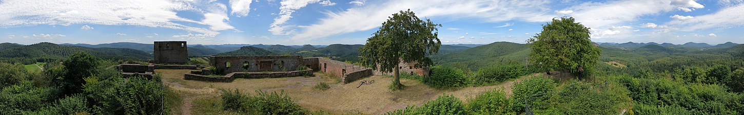
The Dahner Burgengruppe near the town of the same name is a special castle formation . It consists of the castles Altdahn , Grafendahn and Tanstein , which were built at different times but right next to each other on a ridge.
The Castle Information Center at Lemberg Castle not only provides the visitor with a wide range of detailed information about the history, architecture and life in a medieval castle, but also gives a comprehensive overview of the other rock castles in today's border region.
Natural monuments

The Karlstal , which is located in the upper reaches of the Moosalb near Trippstadt , stands out for its natural, primeval forest-like appearance. The Trippstadt district of Johanniskreuz is considered the center of the Palatinate Forest and used to be a health resort. The 200-300 year old mixed oak and beech forests that surround the small hamlet and show autochthonous character are particularly famous (see also the chapter on flora ). They have long been carefully managed in line with the sustainability principle and are particularly known for their valuable veneer oak stocks. It therefore almost goes without saying that the House of Sustainability has also existed in Johanniskreuz since 2005 (see information centers / museums )
Further primeval forest-like "natural forest cells" can also be found in the headwaters of the (Wies) - Lauter below the Weißenberg in one of the core zones of the biosphere reserve and in the border area between Eppenbrunn , Stürzelbronn , Fischbach and Obersteinbach .
Characteristic for the varied landscape of the southern Palatinate Forest are u. a. Over 200 different types of rock formations (see also the chapter on geology and the chapter on surface design ), which not only give the visitor a good insight into their geological conditions, but also the special adaptability of the "sandstone rock vegetation", which is mainly made up of crippled specimens of the Scots pine and common heather and undemanding grasses. Another special feature of this biotope are peregrine falcons , which nest in a row of rocks and are under strict nature protection (access restrictions for climbers and hikers).
Well-known rock formations in the Dahn rock country are the Teufelstisch near Hinterweidenthal, the Jungfernsprung , the Hochstein and the two rock towers Bride and Groom , all of which are in the immediate vicinity of Dahn. For the region around Annweiler and Gossersweiler can u. a. the Asselstein , also the Luger Friedrichsfels, the Hundsfels and the Rödelstein near Vorderweidenthal. The Altschlossfelsen on the Brechenberg near Eppenbrunn in the southwest corner of the Palatinate Forest near the German-French border is also an important natural monument . With a length of around two kilometers, it is the largest rock reef in the Palatinate Forest, where the erosion and weathering processes typical of the red sandstone (e.g. honeycomb weathering) are evident.
In order to bring this rocky landscape closer to the hiker, a number of themed hiking trails have been set up in recent years, of which the Rodalber Felsenwanderweg , the Dahner Felsenpfad, the Busenberger Holzschuhpfad and the Hauensteiner Schusterpfad should be mentioned as examples (see chapter Hiking ). While most of the rocks are reserved for climbers , certain rock reefs can also be hiked (e.g. Puhlstein , Heidenpfeiler and Rötzenstein) or, with the help of climbing systems, climbed with appropriate caution (e.g. the Hühnerstein near Hauenstein).
Information centers and museums
Information centers

The biosphere reserve contains three information centers with different focuses, in which you can find out about geology, climate, fauna and flora, as well as the history and culture of the Red Sandstone Mountains with the help of exhibitions and various events. The focus is on ecological relationships, for which the visitor should be made aware. On the German side, these are the House of Sustainability in Johanniskreuz (see also the chapter on natural monuments ) and the Palatinate Forest / Northern Vosges biosphere house near Fischbach im Wasgau , the latter offering a multimedia exhibition as well as a treetop path and a water and biosphere adventure trail . In La Petite-Pierre (Eng. Lützelstein), in a castle-like building that was built on the ruins of Lützelstein Castle, the administrative center of the Northern Vosges Regional Nature Park (French: Parc naturel régional des Vosges du Nord ) is where the visitor sits can provide information about the natural conditions of the Buntsandstein Vosges analogous to the German institutions; In addition, the social and cultural aspects of the region are also increasingly dealt with.
Museums
Of the large number of museums that can only be found in the Palatinate (see for more details the overview of the Museum Association of Rhineland-Palatinate), only a small selection of those institutions that have a direct or indirect reference to the Palatinate Forest can of course be briefly presented in this chapter exhibit.
The first to be mentioned here is the Palatinate Museum for Natural History - POLLICHIA Museum in Bad Dürkheim, which has various permanent exhibitions and collections on the geology, flora and fauna of the Palatinate (e.g. forest animals, local mushrooms, minerals, etc.) and others informs about special nature conservation topics, whereby the ecological idea is in the foreground. In this context, the Palatinate Forest-Vosges du Nord biosphere reserve is presented to the visitor in an extensive permanent exhibition and the special features of this red sandstone mountains are vividly worked out.
The Historical Museum of the Palatinate in Speyer not discussed because of its focus, the region of present-day Palatinate Forest, although as a separate exhibition area, but the specific Palatinate perspective of the museum almost inevitably leads again and again to particular historical interconnections in which the political and socio-historical changes in the region are illustrated . Examples are the Salier exhibition in 2011 ( Trifels Castle as the center of the Salier Empire), the wine museum with its cultural history of wine and the family hands-on exhibition "Castle Drachenfels", in which life on a medieval rock castle in Wasgau can be traced.
The Dynamikum in Pirmasens is the first science museum ("Science Center") in Rhineland-Palatinate . In April 2008 an “interactive hands-on museum” was set up in the building of the former Rheinberger shoe factory, in which basic physical, mathematical and biological principles can be experienced at 150 interactive experiment stations under the motto “movement”. The museum is aimed in particular at younger visitors who are to be made aware of scientific issues.
The “Max Slevogt Gemäldegalerie” at Villa Ludwigshöhe contains, among other things, paintings by the Impressionist master, which reflect the richness of colors of the southern Palatinate landscape, which can be experienced, for example, from Slevogthof Neukastel above Leinsweiler. A particularly good overview of the rocks and rock castles of the Palatinate and Alsatian Wasgau is also provided by the “impressions” of the painter Emil Knöringer, who uses landscape painting to artistically exaggerate the diversity of the red sandstone landscape.
Industrial monuments


Industrial monuments are z. B. the Stumpfwaldbahn near Ramsen , a museum field railway that has existed since 1996, as well as the Kuckucksbähnel (see also section traffic ), which has been running as a historic steam train from March to October on weekends between Neustadt and Elmstein since 1984. In addition, the visitors to the German Railway Museum in Neustadt get a good overview of almost 150 years of (Palatinate) railway history with the help of many exhibits.
The German Shoe Museum in Hauenstein documents the shoe production that used to be very widespread in the Pirmasens area and places it in a larger industrial and social-historical context. In the building of a former shoe factory, old machines and other manufacturing techniques can be viewed and the changes in shoe production can be vividly experienced (see also settlement history ).
Interesting insights into old professions that used to be found in the Palatinate Forest are conveyed u. a. the brush binder museum in Ramberg ; It uses a variety of exhibits to illustrate the industrial and social development that the Ramberger Valley has undergone over the past centuries.
In the St.-Anna-Stollen ore mine in Nothweiler , visitors are given a guided tour of important mining activities and, related to this, the extreme working conditions of past centuries. This information can then be further deepened in the information center of the visitor mine.
Amusement parks
In the extensive area of the wildlife and hiking park Südliche Weinstrasse there are over 400 animals from 15 European species; various offers for children complete the offer. A comparable facility is the Kurpfalz-Park near Wachenheim in the Middle Palatinate Forest.
Mountain railways
The Rietburgbahn near Edenkoben runs as a chairlift to the eponymous Rietburg , from where there is a good view of the Rhine plain.
The Bad Dürkheim cable car ran from 1973 to 1981 from the city up to the Teufelsstein . It was finally put back into operation around the turn of the year 2017/2018.
hike
The Palatinate Forest has developed into a highly frequented hiking region since the beginning of the last century thanks to its special landscape, its cultural heritage and an infrastructure created primarily by the Palatinate Forest Association . There are more than 100 managed hikers' huts and similar facilities, which are run by the Palatinate Forest Association and the Friends of Nature on a voluntary basis. The hiking bases are often only accessible on foot and are mostly open on weekends.
Hiking trails

The low mountain range is criss-crossed by a dense network of marked hiking trails of more than 12,000 km in length, most of which were created by the Palatinate Forest Association in voluntary work and which are continuously maintained by them. There are also some important international and national long-distance and long-distance hiking trails that connect the Palatinate Forest to the European and national long-distance hiking network.
Well-known examples include a. the Palatinate Way of St. James (marked “Shell on blue ground”), the long-distance hiking trail Pirmasens-Belfort (marked “yellow bar”) or the long-distance hiking trail Franconia-Hessen-Kurpfalz (marked “red cross”). These main hiking routes are supplemented and expanded by a large number of regional hiking trails of different lengths (target and circular hiking trails), whereby themed hiking trails (e.g. forest nature trails), rock hiking trails (e.g. the " Rodalber Felsenwanderweg "), water hiking trails (e.g. . the “Brunnenweg” near Heltersberg and the like) and the premium or rated hiking trails initiated by the Palatinate Tourist Board for a number of years (e.g. “ Palatinate Forest Path ” or “Felsenland Sagenweg” etc.) promise a particularly intense hiking experience. Cross-border hikes are also easily possible in the Buntsandsteingebirge, as the Palatinate Forest Association and Vosges Club (French: " Club Vosgien ") have been using almost identical marking systems since they were founded over 100 years ago (e.g. points, bars, crosses, diamonds of different colors) and have developed a dense network of common paths in the border region. Both hiking associations ensure that the route is not routed on “forest highways”, but instead, if possible, on narrow paths and climbs.
Viewpoints (selection)
Due to its richly structured surface, the Palatinate Forest offers a variety of different views:
Observation towers

For the north-eastern part of the mountains z. B. to name the following goals: Eckkopfturm (near Deidesheim), Bismarck tower (near Bad Dürkheim) and the observation tower on the Weinbiet. From here, the viewer receives a comprehensive panoramic view that extends mainly to the north and east to the Odenwald . The tower on the Steigerkopf (Schänzel), the Rehberg with its tower near Annweiler and the Stäffelsberg tower near Dörrenbach are representative of the central and southern mountain edge. Above all, the mountain pyramid of the Rehberg is known for its extensive panorama (see corresponding picture in the surface design section ). Representative for the central Palatinate Forest are u. a. the tower on the Schindhübel near Iggelbach, the tower on the Eschkopf and above all the Luitpold tower near the Hermersbergerhof, which provides the most comprehensive panoramic view of the Palatinate Forest. According to precise geometrical investigations by Lang, over 350 mountain peaks can be seen from here.
rock
The best known are the Drachenfels between Isenach- and Speyerbachtal and above all the Orensfels near Albersweiler, from which one has an excellent view over the southeastern Wasgau and the region of the southern Weinstrasse . A seat construction is installed on the Kirschfelsen (near Annweiler Forsthaus ), on which the viewer can enjoy a "natural opera" like in a theater. Alpine feelings leave z. B. the Buhlsteine near Busenberg as well as the Hühnerstein near Hauenstein, which can be made accessible by railings and ladders and which can be climbed with appropriate care.
Castles
While the Rietburg above Rhodt serves more as a "viewing balcony" over the Rhine plain, the rock castles of the Wasgau, z. For example, from the "castle triple" Trifels , Anebos and Scharfenberg near Annweiler as well as from Lindelbrunn near Vorderweidenthal, the diversity of the Palatinate red sandstone mountains can be experienced. The Wegelnburg , the highest castle ruin in the Palatinate near Schönau, provides a 360 ° panorama of the German and French Wasgau . From Gräfenstein Castle near Merzalben you can get a good view of one of the core zones of the biosphere reserve in the western Palatinate Forest (see also section Castles and Palaces ).
Landscape of the Palatinate Forest around Lindelbrunn Castle

View from Wegelnburg over the Palatinate Forest


See also
literature
- August Becker: The Palatinate and the Palatinate. 7th edition. (1st ed. 1857). Palatinate Publishing House, Landau / Pf. 2005, ISBN 3-89857-193-9 .
- German Weather Service (ed.): Climate Atlas of Rhineland-Palatinate . Verlag Deutscher Wetterdienst, Bad Kissingen 1957, ISBN 3-88148-135-4 .
- Michael Geiger u. a. (Ed.): Palatinate regional studies, contributions to geography, biology, folklore and history. Vol. 1 . Self-published, Landau / Pf. 1981
- Michael Geiger u. a. (Ed.): The Palatinate Forest, portrait of a landscape . Publishing house Palatinate cultural studies, Landau / Pf. 1987, ISBN 3-9801147-1-6 .
- Michael Geiger: Palatinate Forest Biosphere Reserve - Vosges du Nord - model region for sustainable development across borders . In: Christoph Becker (Hrsg.): Grenz / Touren. Excursions between the Maas, Moselle, Saar and Rhine. Trier Geographic Studies. H. 28. Geographische Gesellschaft Trier 2005, pp. 309–333.
- Michael Geiger u. a. (Ed.): Geography of the Palatinate . Publishing house Palatinate cultural studies, Landau / Pf. 2010, ISBN 978-3-9812974-0-9 .
- Daniel Häberle : The Palatinate Forest: Origin of its name, its geographical delimitation and the geology of its area . Crusius Verlag, Kaiserslautern 1911 (special print)
- Adolf Hanle: Meyer's nature guide, Palatinate Forest and Wine Route. Bibliographisches Institut, Mannheim 1990, ISBN 3-411-07131-1 .
- Karl Heinz: Pfalz: with Weinstrasse; Landscape, history, culture, art, folklore. Glock and Lutz Verlag, Heroldsberg 1976, ISBN 3-7738-2014-5 .
- Emil Heuser: New Palatinate Leader. 14th edition. Waldkirch-Verlag, Ludwigshafen 1979, DNB 800413350 . (1st edition 1900)
- Jürgen Keddigkeit u. a .: Palatinate Castle Lexicon , 4 volumes. Verlag Bezirksverband Pfalz, Inst. F. Palatinate. History, Kaiserslautern 2002-2007, Vol. 1: ISBN 3-927754-51-X ; Vol. 2: ISBN 3-927754-48-X ; Vol. 3: ISBN 3-927754-54-4 ; Vol. 4: ISBN 3-927754-56-0 .
- Ulrike Klugmann (Ed.): Palatinate Forest Nature Park. Harksheider Verlagsgesellschaft, Norderstedt 1983, OCLC 180520264 . ( Nature magazine outside , No. 24)
- Emil Knöringer: The Wasgau with its rocks and rock castles . Publishing house Palatinate Art Dr. Hans Blinn, Landau / Pfalz 2nd edition 1985, ISBN 3-922580-16-5 .
- State Office for Geology and Mining Rhineland-Palatinate (Ed.): Geology and Earth History of Rhineland-Palatinate. Schweizerbart'sche Verlagbuchhandlung, Stuttgart 2005, ISBN 3-510-65265-7 .
- Roland Walter: Geology of Central Europe . Schweizerbart'sche Verlagbuchhandlung, Stuttgart 2007, ISBN 978-3-510-65229-7 .
Movie
- Wild Germany. The Palatinate Forest. Documentary, Germany, 2012, 43 min., Script, director and camera: Klaus Weißmann, Tobias Mennle, Rolf Sziringer, production: NDR Naturfilm, SWR , arte , first broadcast: May 22, 2012 on arte, summary: Wildes Deutschland (1) - The Palatinate Forest ( memento of October 11, 2012 in the Internet Archive ) with online video.
Web links
- Website of the Palatinate Forest Nature Park e. V.
- History of the Palatinate Forest
- Panoramic pictures of the Palatinate Forest (Trifels, Madenburg, Lindelbrunn, Landeck, Neuscharfeneck, Ramburg)
- Sandstone cliffs and castles in the southern Palatinate Forest
Individual evidence
- ↑ Helmut Beeger u. a .: The landscapes of Rheinhessen-Pfalz - naming and spatial delimitation. In: Reports on German regional studies , Volume 63, Issue 2, Trier 1989, pp. 327–359.
- ^ A b c Emil Meynen , Josef Schmithüsen : Handbook of the natural spatial structure of Germany . Federal Institute for Regional Studies, Remagen / Bad Godesberg 1953–1962 (9 deliveries in 8 books, updated map 1: 1,000,000 with main units 1960).
- ↑ The Palatinate Forest Nature Park . Website of the Palatinate Forest-Northern Vosges Biosphere Reserve. Retrieved August 12, 2020.
- ↑ Michael Geiger: The Palatinate Forest in a geographical overview . In: Michael Geiger / Günter Preuß / Karl-Heinz Rothenberger (Hrsg.): The Palatinate Forest portrait of a landscape . Pfälzische Verlagsanstalt, Landau id Pfalz 1987, pp. 9–58.
- ↑ Palatinate Forest Nature Park e. V. (Ed.): Care and development plan . Lambrecht 2002 ( Memento from October 21, 2012 in the Internet Archive ) (PDF; 818 kB). Retrieved October 19, 2011.
-
↑ Various authors: Geographische Landesaufnahme: The natural spatial units in single sheets 1: 200,000 . Federal Institute for Regional Studies, Bad Godesberg 1952–1994. → Online maps Pages marked
with an asterisk (*) have not yet been included in the list.- Sheet 150: Mainz (Harald Uhlig 1964; 39 pages)
- Sheet 160: Landau id Pfalz (Adalbert Pemöller 1969; 47 pages)
- Sheet 169 *: Rastatt (Heinz Fischer 1967; 31 pages)
- ↑ Map service of the landscape information system of the Rhineland-Palatinate nature conservation administration (LANIS map) ( notes )
- ↑ Natural area table with area information from the State Office for the Environment, Water Management and Trade Inspectorate Rhineland-Palatinate (PDF; 250 kB)
- ↑ Landscape profile of the large landscape 17 of the landscape information system of the nature conservation administration Rhineland-Palatinate ( notes )
- ↑ Following a suggestion by Beeger and Geiger, the Annweiler Felsenland is separated from the Dahner Felsenland along the southern continuation of the Elmsteiner Fault .
- ↑ Queich - and Eisbach -Talungen, trifels castle
- ↑ together with the north-eastern spur to the maggot castle
- ↑ Michael Geiger: The landscapes of the Palatinate . In: Michael Geiger u. a. (Ed.): Geography of the Palatinate . Publishing house Palatinate cultural studies, Landau / Pf. 2010, p. 99.
- ↑ Kurt Reh: The Palatinate Forest - An introduction to landscape and naming. In: Michael Geiger u. a. (Ed.): Palatinate regional studies, contributions to geography, biology, folklore and history. Vol. 1 . Self-published, Landau / Pf. 1981, p. 381.
- ↑ Winfried Lang: The Luitpold Tower and its panorama . Plöger Medien GmbH, Annweiler 2009, p. 75.
- ↑ Daniel Häberle: The Palatinate Forest: Origin of its name, its geographical delimitation and the geology of its area. Crusius Verlag, Kaiserslautern 1911 (special print), p. 7.
- ↑ a b Michael Geiger u. a. (Ed.): The Palatinate Forest, portrait of a landscape . Publishing house Palatinate cultural studies, Landau / Pf. 1987, p. 18.
- ↑ Winfried Lang: The Luitpold Tower and its panorama . Plöger Medien GmbH, Annweiler 2009, p. 61.
- ↑ Jürgen Keddigkeit : The Palatinate Forest as a historical-political space . In: Michael Geiger u. a. (Ed.): The Palatinate Forest, portrait of a landscape . Publishing house Palatinate cultural studies, Landau / Pf. 1987, pp. 63-92.
- ↑ Michael Geiger: Villages and Cities in the Palatinate . In: Michael Geiger u. a. (Ed.): Geography of the Palatinate . Publishing house Palatinate cultural studies, Landau / Pf. 2010, pp. 202-221.
- ↑ Roland Paul: Of old professions in the Palatinate Forest . In: Michael Geiger u. a. (Ed.): The Palatinate Forest, portrait of a landscape . Publishing house Palatinate cultural studies, Landau / Pf. 1987, pp. 239-252.
- ^ After Heinz Ellenberg: Farmhouse and Landscape. Ulmer, Stuttgart 1999, p. 403, these houses are strikingly similar to those in the Spessart.
- ^ Hanni Mädrich: The shoe industry . In: Michael Geiger u. a. (Ed.): The Palatinate Forest, portrait of a landscape . Publishing house Palatinate cultural studies, Landau / Pf. 1987, pp. 207-214.
- ↑ These are representatives of the Palatinate Forest Association (PWV), the Federation for Environment and Nature Conservation Germany (BUND) , the Pollichia Association for nature research and conservation , the Association of Friends of Nature and the nature sports associations .
- ↑ Jürgen Müller: Source of power for people sitting down . In: Die Rheinpfalz , Supplement Your Weekend , January 17, 2009.
- ↑ Michael Geiger: An overview of the natural and cultural landscapes of the Palatinate . In: Michael Geiger u. a. (Ed.): Geography of the Palatinate . Publishing house Palatinate cultural studies, Landau / Pf. 2010, pp. 155–158.
- ↑ State ordinance on the "Palatinate Forest Nature Park" as the German part of the Palatinate Forest-Northern Vosges biosphere reserve of January 22, 2007 . Website of the Ministry for the Environment, Forests and Consumer Protection of the State of Rhineland-Palatinate. Retrieved June 17, 2011.
- ↑ 50 years of the Palatinate Forest Nature Park ( memento of October 24, 2013 in the Internet Archive ), report from Pollichia-Kurier 2/2009.
- ↑ Michael Geiger et al. a. (Ed.): The Palatinate Forest in a geographical overview . In: The Palatinate Forest, a portrait of a landscape . Publishing house Palatinate cultural studies, Landau / Pf. 1987, pp. 21-46.
- ^ Roland Walter: Geology of Central Europe . Schweizerbart'sche Verlagsbuchhandlung, Stuttgart 2007, pp. 241-258.
- ↑ Ulrike Klugmann (ed.): Palatinate Forest Nature Park, nature magazine outside, No. 24 . Harksheider Verlagsgesellschaft, Norderstedt o. J., pp. 20–29.
- ↑ Tensile failure model of the ditch formation Website by Christian Röhr: Der Oberrheingraben . Retrieved May 6, 2011.
- ↑ Jost Haneke / Michael Weidenfeller: The geological building units of the Palatinate . In: Michael Geiger u. a. (Ed.): Geography of the Palatinate. Publishing house Palatinate cultural studies, Landau / Pf. 2010, cf. Table and map pp. 76–77.
- ^ Geological overview map of Rhineland-Palatinate Website of the State Office for Geology and Mining Rhineland-Palatinate. Retrieved April 8, 2011.
- ↑ Topographic maps 1:25 000 and 1:50 000 of the State Office for Surveying and Geographic Base Information Rhineland-Palatinate. In: website of the State Office for Surveying and Geobasisinformation Rhineland-Palatinate . Retrieved April 1, 2011.
- ↑ Hubert Heitele, Dietmar Kotke, Herrmann Fischer: The groundwater and its use . In: Michael Geiger u. a. (Ed.): The Palatinate Forest, portrait of a landscape . Publishing house Palatinate cultural studies, Landau / Pf. 1987, pp. 253-262.
- ↑ a b GeoExplorer of the Rhineland-Palatinate Water Management Authority ( information )
- ↑ Michael Geiger et al. a. (Ed.): Geography of the Palatinate . Publishing house Palatinate cultural studies, Landau / Pf. 2010, p. 138 f.
- ↑ German Weather Service Weather and Climate from a single source. In: Website of the German Weather Service . Retrieved March 14, 2011.
- ^ German Weather Service (ed.): Climate Atlas of Rhineland-Palatinate . Verlag Deutscher Wetterdienst, Bad Kissingen 1957, sheet 6 f.
- ^ German Weather Service (ed.): Climate Atlas of Rhineland-Palatinate . Verlag Deutscher Wetterdienst, Bad Kissingen 1957, pages 3–5.
- ^ Meteomedia Verification ( Memento from October 17, 2013 in the Internet Archive ). Meteomedia AG website. Retrieved March 16, 2011.
- ↑ Michael Geiger et al. a. (Ed.): Geography of the Palatinate. Publishing house Palatinate cultural studies, Landau / Pf. 2010, p. 143.
- ↑ Edmund Mainberger: The forest . In: Michael Geiger u. a. (Ed.): The Palatinate Forest, portrait of a landscape . Publishing house Palatinate cultural studies, Landau / Pf. 1987, pp. 101-126.
- ↑ a b c d Biodiversity in the Palatinate Forest. In: Geo-Portal. Retrieved August 18, 2013
- ↑ Ulrike Klugmann (ed.): Palatinate Forest Nature Park, nature magazine outside, No. 24 . Harksheider Verlagsgesellschaft, Norderstedt o. J., pp. 33–36.
- ↑ Norbert Hailer: Natural forest cells, primeval forest of the future . In: Michael Geiger u. a. (Ed.): The Palatinate Forest, portrait of a landscape . Publishing house Palatinate cultural studies, Landau / Pf. 1987, pp. 127-132.
- ↑ Norbert Hailer: Natural forest cells, primeval forest of the future . In: Michael Geiger et al. (Ed.): The Palatinate Forest, a portrait of a landscape . Verlag Pfälzische Landeskunde, Landau / Pfalz 1987, p. 127-132 .
- ^ Günter Preuss: The Palatinate Forest, habitat for plants and animals . In: Michael Geiger u. a. (Ed.): The Palatinate Forest, portrait of a landscape . Publishing house Palatinate cultural studies, Landau / Pf. 1987, pp. 133-164.
- ^ Günter Preuss: The Palatinate Forest, habitat for plants and animals . In: Michael Geiger u. a. (Ed.): The Palatinate Forest, portrait of a landscape . Publishing house Palatinate cultural studies, Landau / Pf. 1987, pp. 141-145.
- ^ Website of the Palatinate Forest-Vosges du Nord biosphere reserve ( Memento from August 12, 2013 in the Internet Archive ). Retrieved May 31, 2011.
- ↑ Rhineland-Palatinate wants Federal Council initiative on »Fuel Dumping«. In: neue-deutschland.de , September 15, 2018, accessed on September 22, 2018.
- ↑ kerosene rain, no thanks! Transparency yes please! change.org, accessed September 24, 2018 .
- ↑ Wilhelm Weber: Important architectural and art monuments in the Palatinate Forest . In: Michael Geiger u. a. (Ed.): The Palatinate Forest, portrait of a landscape . Publishing house Palatinate cultural studies, Landau / Pf. 1987, pp. 309-336.
- ↑ The South Palatinate climbing area. In: Website of the Palatinate Climbers Association. Retrieved May 22, 2011.
- ^ Website of the Rhineland-Palatinate Museum Association. Retrieved May 31, 2011.
- ^ Emil Knöringer: The Wasgau with its rocks and rock castles . 2nd Edition. Publishing house Palatinate Art Dr. Hans Blinn, Landau / Pfalz 1985, p. 4 ff.
- ^ Hikers' huts in German low mountain ranges
- ↑ Palatinate Forest Association Huts. Retrieved April 19, 2020 .
- ↑ Palatinate Forest Association , directory of rest houses, shelters, hiking homes , a total of 102, Palatinate Forest Association e. V., 67433 Neustadt adW
- ↑ Landesvermessungsamt Rhineland-Palatinate, topographic maps 1: 25000 with hiking trails , as well as topographic maps 1: 50,000 with hiking and cycling trails between the Rhine and the Palatinate Forest , official hiking and cycling maps of the Palatinate Forest Association showing all hiking trails and cycling trails
- ↑ Winfried Lang: The Luitpold Tower and its panorama. Plöger Medien GmbH, Annweiler 2009, pp. 108–121.