
District of Dachau
| coat of arms | Germany map |
|---|---|

|

Coordinates: 48 ° 20 ' N , 11 ° 22' E |
| Basic data | |
| State : | Bavaria |
| Administrative region : | Upper Bavaria |
| Administrative headquarters : | Dachau |
| Area : | 579.18 km 2 |
| Residents: | 154,899 (Dec. 31, 2019) |
| Population density : | 267 inhabitants per km 2 |
| License plate : | DAH |
| Circle key : | 09 1 74 |
| NUTS : | DE217 |
| Circle structure: | 17 municipalities |
| Address of the district administration: |
Weiherweg 16 85221 Dachau |
| Website : | |
| District Administrator : | Stefan Löwl ( CSU ) |
| Location of the district of Dachau in Bavaria | |
  |
|
The district of Dachau is located northwest of Munich in the administrative district of Upper Bavaria . The district town is Dachau . The district town and district belong to the Munich metropolitan region .
geography
Location and landscape


The district of Dachau, with its connections by road or rail, is well developed in terms of traffic and is close to the state capital Munich.
To the north of the district town of Dachau, the landscape is undulating and undulating and is used intensively for agriculture. The centrally located Markt Indersdorf is the most important center of the district after Dachau.
In the district there are still remnants of some moors in the south, such as the Dachauer Moos or the " Schwarzhölzl " nature reserve . At the beginning of the 19th century, after the last bogs had been drained, a systematic peat extraction began. This moor landscape originally extended from Fürstenfeldbruck to Freising . Even today, the moor area is known for prolonged ground fog .
Colloquially, one also speaks of the Dachau region .
Rivers
The most important rivers are the Amper , the Glonn and the Ilm .
The Amper forms the natural border between the moorland in the south and the hilly area to the north , which characterizes the landscape in the rest of the district. Coming from the Ammersee , this river reaches the district area southwest of Dachau and then flows through the extreme southeast of the district in a northeast direction. East of Dachau, shortly before Hebertshausen , the Würm flows into the Amper. It drains Lake Starnberg . The millers of the Würmmühle in Dachau have been responsible for the transition over the Würm-Amper-Aue, where the Würm meets the Amper, since the 10th century. West of Dachau, in Mitterndorf , the Amper flows into the Maisach .
The middle of the circle flows through the Glonn in a west-east direction . This small river flows into the Amper in the Freising district , which flows into the Isar further northeast in Moosburg . The Glonn drains around 2/3 of the district area.
The north of the district is roughly shaped by the Ilm , which rises on the one hand in Tandern and on the other at the Altowald near Altomünster and flows together behind Pipinsried . After 75 kilometers it feeds the Danube tributary Abens .
All rivers drain into the Danube .
topography
The district of Dachau is characterized by a gently undulating hilly landscape of the Danube-Isar hill country , which runs out in the south from Dachau into the Munich gravel plain. The rivers form sinks with moors, which predominantly run through the district in a west-east direction. They are remnants of post-glacial lakes. The incised courses of the Amper, Glonn and Ilm are delimited by hilly landscapes.
From a topographical point of view, the higher elevations are between 535 and 520 m above sea level. NHN in the north and northwest of the district, the highest at 557 m above sea level. NHN in Biberecker Holz not far from Kreuzholzhausen or Deutenhausen . At Schmarnzell is 551 m above sea level. NHN the second highest point. The highest village is Hohenzell (537 m above sea level ) near Altomünster. The deepest landscape points are along the outflows of the Amper and the Glonn in the southeast and east into the Freising district at approx. 450 m above sea level. NHN .
Land use
Agriculture
The district of Dachau is used intensively for agriculture, mainly as arable land. Three quarters of the area, almost 74%, is used for agriculture. Along the Amper and Glonn and on the partly cultivated moor soils of the Dachauer Moos there are also meadows and pastures.
Forest
The forest was pushed back onto knolls, steep slopes and gravel soils through clearing. Only 15.7% of the district area is forested. The communities Odelzhausen (25.7%), Erdweg (23.2%), Hilgertshausen-Tandern (21.8%) and Sulzemoos (20.8%) have the largest share of forests. The communities with the least forest are Karlsfeld with 3.3% forest and the city of Dachau with 6.1%.
Other areas
Around 1% are water surfaces and around 8% are built-up residential and traffic areas. The remaining areas (economic and other infrastructure facilities) make up around 1.3%.
nature
Natural spaces

.JPG)
There are two nature reserves , four landscape protection areas , three FFH areas and at least one designated geotope in the district (as of April 2016).
In the district of Dachau, the following areas have been designated as fauna, flora, habitat (FFH) and bird protection areas since 2001;
- Nature reserve " Weichser Moos " (area 55 ha)
- Ampertal (area including the districts of Fürstenfeldbruck and Freising 1818 ha)
- Ditches and remains of fens in the Dachauer Moos (area including the city of Munich and the Munich district 304 ha).
The following are designated landscape protection areas:
- Glonntal with 1,833 hectares
- Palsweiser Moos with an area of approx. 312 hectares
- Amperauen with Hebertshauser Moos and Inhauser Moos with an area of 1,820 ha
- Landscape parts near Thalhausen with an area of 11 hectares.
Around 150 trees, groups of trees and avenues are protected as natural monuments. The protection purpose is the preservation of these individual creations of nature in the public interest due to their outstanding beauty or their ecological or local significance. The oldest trees in the district that are protected by this ordinance are the castle oak at the western entrance to Eisolzried (approx. 600 years old) and the two linden trees (approx. 600 and 350 years old) at the entrance to the ravine north of the church leading out of Obermarbach.
See also
- List of nature reserves in the Dachau district
- List of landscape protection areas in the district of Dachau
- List of FFH areas in the district of Dachau
- List of geotopes in the Dachau district
- List of natural monuments in the Dachau district .
leisure
The rivers at Amper, Glonn or Ilm invite you to go on bike tours. The 7-Klöster-Weg connects seven monasteries in the district of Dachau and the Wittelsbacher Land west of it on three routes of a total of almost 100 km for bicycle tourists.
The historic Altbaierische Oxenweg is located in the Glonntal and, as one of several ox- driving routes , led from Augsburg to the Dachau region and on to Hungary. Some places are on the so-called Dachau Jakobsweg , which Dachau-Agil has signposted with the European Jakobswegzeichen.
Numerous larger or smaller bathing lakes, swimming pools and a natural pool invite you to swim.
Neighboring counties
Limits
The district borders clockwise, starting in the north, on the districts of Pfaffenhofen an der Ilm , Freising and Munich , on the independent city of Munich and on the districts of Fürstenfeldbruck and Aichach-Friedberg .
Border locations (loci maxima)
Weitenried is the westernmost place in the district, Karlsfeld the southernmost, Maisteig (municipality of Haimhausen ) the easternmost and Eichenried (municipality Hilgertshausen-Tandern ) the northernmost place.
climate
The climate in Dachau is mild and generally warm and temperate. "Cfb" is the Köppen-Geiger classification . The average annual temperature in Dachau is 8.1 ° C. About 886 mm of precipitation falls annually.
There is significant rainfall throughout the year in Dachau. Even the driest month of February still has high rainfall with an average of 48 mm. Compared to the wettest month, June, with an average of 118 mm of precipitation, the difference is 70 mm.
Average temperatures fluctuate around 19.1 ° C over the course of the year between the warmest month of July and the coldest January. The average temperature in July is 17.5 ° C. In January the average temperature is -1.6 ° C.
| Dachau (1982 - 2012) | ||||||||||||||||||||||||||||||||||||||||||||||||
|---|---|---|---|---|---|---|---|---|---|---|---|---|---|---|---|---|---|---|---|---|---|---|---|---|---|---|---|---|---|---|---|---|---|---|---|---|---|---|---|---|---|---|---|---|---|---|---|---|
| Climate diagram | ||||||||||||||||||||||||||||||||||||||||||||||||
| ||||||||||||||||||||||||||||||||||||||||||||||||
|
Monthly average temperatures and precipitation for Dachau (1982 - 2012)
Source: Climate-Data.org
|
||||||||||||||||||||||||||||||||||||||||||||||||||||||||||||||||||||||||||||||||||||||||||
history
Early history
The Dachau region was part of the Roman province of Raetia for 500 years and was probably not insignificant because of the Roman roads that ran here . On the one hand there was the Roman road leading from Salzburg to Augsburg, with the crossing of the Isar at Gauting and the Amper at Schöngeising, on the other hand the road from Wels to Augsburg, with the crossing of the Isar at Oberföhring, the Amper at the Würmmühle (with Roman road station Ambra) and the Glonn near Erdweg, and finally around the junction in Erdweg in the direction of Freising and from here Isar down to the Danube, with crossing the Amper in Haimhausen. Until after 1200 these roads remained the main arteries of this region.
The former Roman fiscal estate later formed part of the manorial and economic basis of the Merovingian kings and became royal property and partly ducal property of the Agilolfingian dukes. The rest of the room was shared by the numerous clan members of the privileged sexes. In between there were still the manor houses of the Germanic noble freemen who had already settled here in Roman times, as well as the courtyards of the Celto- Roman population who had sunk to semifree .
middle Ages
After the fall of Tassilos III. in 788 the Agilolfingian ducal estate was incorporated into the royal estate. Bavaria was divided into numerous counties, in which counts ruled on behalf of the Carolingian kings. As before, this rule only applied to the royal estate and the serfs who worked there . The counts had no influence on the land and the people of the nobility. You were only entitled to voluntary arbitration in aristocratic disputes. At the time, the county in this area included the court locations of Ampermoching, Eching, Haimhausen, Vierkirchen, Bergkirchen, Emmering, Föhring, Ainhofen and Tandern, among others, the Königsgut variety Freising, Hohenkammer, Mammendorf, Gilching, Überacker and Fröttmaning.
Since the 10th century, the royal estate became a considerable property of the counts. With the prevailing aristocratic division of inheritance, this meant that soon several count families were wealthy in our area, who exercised count rights over their land and their people, and that the rights of the actual counts were increasingly restricted. The counts Altmann and Ernst v. Can be found in the county around Freising in the 11th and early 12th centuries. Ottenburg-Grögling finally had to give up their local county rights around 1130 after the Counts of Scheyern had succeeded in acquiring a sizable property here and in addition to gaining the bailiwick rights (= protective rights) over the rich property of the Freising Cathedral and Freising monasteries.
Not much changed in this respect due to the division of the Scheyern rulership rights around the year 1100 on three lines: the younger Counts of Scheyern, who soon named themselves after Wittelsbach , the Counts of Valley and the Counts of Dachau. The concentration of ownership of the branch line named after Dachau in this area was the reason for the construction of the first Dachau castle, which made Dachau a center of power for the first time. In the following years Dachau gradually pushed back the old centers of the royal estate districts, which had remained courts of law. The Counts of Dachau relied in their rule over the country and its people on servants who had to perform administrative tasks and were obliged to achieve military success. Many poor noblemen, but also servants of the Freising Cathedral, felt compelled to face pressure from the powerful counts.
Wittelsbach Regional Court
When in 1182 with Count Konrad III. the last male offspring of the Dachau counts had died, Duke Otto I von Wittelsbach acquired Dachau Castle with the associated property and the knightly servant. Thus the area belonged to Old Bavaria . The Dachau rulership rights served as a welcome addition to his son, who soon followed, and were useful in his endeavors to establish as closed a state as possible. The Wittelsbachers achieved this goal through the organizational innovation of establishing offices in the central locations in their hands, from which the surrounding property was administered, as well as regional courts as central courts and caste offices as forerunners of today's tax offices. Instead of a count who was dependent on the king, a ducal-sovereign official administered the old county.
The Dachau Regional Court was not a closed area in the early days of its existence. Initially, the interspersed possessions of the Andechser, as well as other count families, such as B. the rule Haimhausen, exempte areas. In addition, it was only possible gradually to lift the old county scrappage and to take the cases to be judged there to the regional court in Dachau. It was only after the Count of Andechs died out in 1248 that the Dachau district court in the south-west could be pushed to the later borders and the Esting henchman's office formed. The Feldmoching henchman's office also only seems to have been set up in the middle of the 13th century when the attempts of the Freising bishops to develop a state rule that extended as far as Munich were thwarted. The formation of the District Court of Kranzberg around 1230, to which earlier parts of the District Court of Dachau were assigned, meant an intensification of rule. By 1400 the regional court had reached the later known area and was divided into three henchman offices: the upper office (Esting), the lower office (Puchschlag) and the office auf`m Gfild (Feldmoching). In the second half of the 15th century, the Dachau henchman office was created through the division of the sub-office. In 1639 the Puchschlag office was relocated to Schwabhausen and the Feldmoching office to Neuhausen.
In the west, the Landsberg regional court bordered, which reached in a wedge as far as Aich close to Fürstenfeldbruck, while the Dachau regional court again advanced in a corner to Grafrath. Bruck, Mammendorf, Hattenhofen and Mittelstetten are to be mentioned as border towns still belonging to the Dachau regional court. The district court Friedberg was adjacent to Vogach. From Poigern over Weihern near Egenhofen, Dietenhausen, Odelzhausen and Taxa to near Unterweikertshofen, the Glonn formed the regional court border. Here a corner pushed its way to Langengern in the Aichach district court, whereby Guggenberg and Petersberg also belonged to the Dachau district court. In the further course the Glonn formed the border to the district court Kranzberg, which only crossed the southern bank of the Glonn at Zillhofen, Jedenhofen and Asbach. Kollbach was even an exclave of the Pfaffenhofen Regional Court. The northern part of today's Dachau district was part of the district court of Kranzberg, the area around Altomünster belonged to the district court of Aichach. In the further course, the later district boundary formed the boundary of our district court, which, however, reached in the southeast via Schleissheim, Freimann and the major part of today's English Garden to the Chinese Tower in Munich. The castle truce column, which first stood on Kurfürstenplatz and since the late 1950s on Elisabethplatz in Munich, shows that Schwabing was part of the Dachau district court, as well as the Olympic site, the Marsfeld and the Bavariahöhe. In the south and southwest, the district court of Dachau bordered the district court of Starnberg and included the places Unter- and Mittersendling, Laim, Nymphenburg, Pipping, Aubing, Lochhausen, Gröbenzell, Roggenstein and Wagelsried, as well as the Schöngeisinger Forst, while Schöngeising itself already belonged to Starnberg . The Dachau district court thus encompassed a room that was considerably larger than that of today's district. In the middle of the 13th century, the Dachau market was founded at this important administrative and court location in Dachau. He gradually received additional rights, up to and including the setting up of a private ban market endowed with Munich law, which was a member of the Bavarian state estates.
In Dachau, a magnificent renaissance renaissance castle was built in the second half of the 16th century .


During this time, some of the former ministerials had risen to become a new wealthy nobility or their property passed into the hands of the new patrician nobility or official nobility. In the same way as the Hochstift Freising and the monasteries Fürstenfeld and Indersdorf, this nobility managed to unite rulership rights in individual settlements, which are summarized under the name Hofmarksrecht. It was not until the 17th century that the well-known court brands with their court marque locks were fully developed. In the 17th and 18th centuries, the lords of the court ruled largely unrestricted in their court brands. Members of powerful aristocratic families were occasionally able to defy sovereign laws themselves.
Regional court from 1802
The reorganization and reorganization of the old Bavarian regional courts in 1802, suggested by Maximilian von Montgelas, eliminated the old privileges of the Dachau and Altomünster markets in addition to numerous other special rights, such as the Hofmark rights.
When the Bavarian administration was first reorganized in the course of the secularization of many monasteries and the Freising Monastery, the Dachau Regional Court remained almost unchanged. He was only assigned the supervision of the Hofmark Indersdorf (previously district court Kranzberg). In contrast, the Neuhausen area switched to the then newly formed Munich Regional Court. From 1808 the district court of Dachau belonged to the Isar district . In 1808, the Dachau district court was divided into 51 tax districts, which did not take into account the lower court affiliation of the individual places, but generally chose parish villages as the main tax districts. The disregard of historically grown togetherness led to difficulties, which were taken into account when the municipal law of 1818 wanted to create municipal self-governing bodies. The political communities formed at that time continued to exist until the community reform in the 1970s.
On October 29, 1823, some communities, such as Esting , were assigned to the newly established Fürstenfeldbruck district court.
In 1838 the district court of Dachau came to the district of Upper Bavaria .
By the Bavarian District Council Act of May 28, 1852, a corporate association of the municipalities located in the Dachau Regional Court at that time was formed, which performed the supraregional self-administration tasks. The representative body of the newly formed district parish was the district council. However, as the state representative, the district judge remained the executive supreme administrative body in the Dachau district court. Thus the district council was still completely under state trustees.
District office from 1862
In 1862, the judiciary was separated from the administration in Bavaria: the Dachau district office now followed the Dachau regional court of the same area . After the First World War , the district office of Dachau continued to be headed by a district officer, but the self-administration law of May 22, 1919 resulted in the elimination of the state council and an expansion of the self-administration tasks.
District from 1939
On January 1, 1939, as everywhere in the German Reich, the designation district was introduced. The district office of Dachau became the district of Dachau.
District from 1945
The district of Dachau became responsible for local self-government after the Second World War .
District from 1972
As part of the regional reform in Bavaria , the district was enlarged on July 1, 1972. New arrivals to the county
- the communities Altomünster , Hilgertshausen , Hohenzell , Kiemertshofen , Kleinberghofen , Oberzeitlbach , Randelsried , Stumpfenbach , Tandern , Thalhausen and Wollomoos from the dissolved district of Aichach
- the communities Höfa , Pfaffenhofen an der Glonn , Sittenbach , Unterumbach and Weitenried from the dissolved district of Friedberg as well
- the community of Ebertshausen from the Fürstenfeldbruck district .
The district of Dachau in turn gave the municipality of Fahrenzhausen in the east to the district of Freising . The district thus reached its present size. In fact, areas were given up in the east and areas in the west and south-west were included.
On January 1, 1984, the village of Weißling was incorporated into Petershausen and came from the Freising district to the Dachau district.
Demographic statistics
Overall development
The district of Dachau gained more than 47,000 inhabitants between 1988 and 2018 or grew by 44.2%.
The population figures from 1840 onwards refer to the territorial status on May 25, 1987.
|
|
|
Development by community
The municipalities developed between 2008 and 2018 as follows:
| place | coat of arms | Population (2018) | Change (2008-2018) | Change (2008-2018) (%) |
|---|---|---|---|---|
| City of Dachau |
|
47,400 | 5,722 | 13.7 |
| Karlsfeld |
|
21,596 | 3,412 | 18.8 |
| Market Indersdorf |
|
10,441 | 1,119 | 12.0 |
| Odelzhausen |
|
5,128 | 900 | 21.3 |
| Haimhausen |
|
5,636 | 882 | 18.6 |
| Bergkirchen |
|
7,770 | 617 | 8.6 |
| Altomünster |
|
7,925 | 590 | 8.0 |
| Petershausen |
|
6,551 | 521 | 8.6 |
| Hebertshausen |
|
5,701 | 507 | 9.8 |
| Erdweg |
|
5,001 | 486 | 8.8 |
| Sulzemoos |
|
3,099 | 447 | 16.9 |
| Schwabhausen |
|
6,494 | 412 | 6.8 |
| Soft |
|
3,509 | 397 | 12.8 |
| Pfaffenhofen ad Glonn |
|
2.159 | 365 | 20.3 |
| Vierkirchen |
|
4,571 | 279 | 6.5 |
| Hilgertshausen tanderns |
|
3.423 | 278 | 8.8 |
| Röhrmoos |
|
6,490 | 149 | 2.3 |
Foreign nationals
In 2018, the population consisted of 24,539 foreign nationals (proportion of foreigners 15.9%), including 2,642 from Greece, 2,365 from Romania and 2,237 from Croatia. In 2018 there were 489 naturalizations.
fluctuation
The fluctuation (inflows and outflows in% of the population) averaged 14.7% in the years 2008-2018 and 14.5% in 2018.
Age groups
In 2018 the age distribution was:
- 27,151 people (up to 17 years)
- 98,342 people (18 to 64 years)
- 28,390 people (65 and over).
Denomination statistics
According to the 2011 census , 12.4% of the population were Protestant , 54.5% Roman Catholic and 33.0% were non-denominational , belonged to another religious community or did not provide any information. The number of Catholics has decreased since then. According to church statistics, 72,269 (46.8%) of 154,544 district citizens were Catholics at the end of December 2019.
economy
Industry sectors
Industry and medium-sized companies
Numerous, mostly medium-sized companies are spread across the district. Globally active and highly innovative high-tech companies can be found alongside high-growth startups, numerous craft and commercial enterprises and service providers of all kinds. The district of Dachau is particularly characterized by the stable mix of industries with a focus on the areas of automotive, information and communication technology, services and high-tech, as well as health and medical technology out. The Chamber of Industry and Commerce gives 1,890 industrial companies, 1,774 retail companies, 1,430 wholesalers, 582 companies for traffic, transport and logistics, 473 catering companies, 5,229 service companies for the district.
A recent specialty in the Hebertshausen community is oil production . The town of Prittlbach is one of currently two oil fields in Bavaria where the black gold is actually extracted. Wind energy is also used with wind turbines .
Brewing

Seven active breweries , founded between 1450 and 2017 (founding years in brackets) are spread across the Dachau region :
- Amperbräu, Neuhimmelreich (approx. 2010)
- Kapplerbräu , Altomünster (1561)
- Cellar brewery, Prittlbach (2014)
- Maierbräu , Altomünster (1886)
- Lenz Brewery, Niederdorf near Hilgertshausen-Tandern (2017)
- Castle Brewery Odelzhausen, Odelzhausen (1450)
- Tobiasbräu Ried, Ried near Markt Indersdorf (2007).
Economic and structural data
Perspectives
In the Future Atlas 2016 , the district of Dachau was ranked 55th out of 402 districts and independent cities in Germany, making it one of the places with "high future opportunities".
Purchasing power
With a purchasing power index of 122.7 percent of the national average (100 percent) or 27,291 euros, the district has the ninth-highest per capita income of all districts in the Federal Republic of Germany (as of 2017).
employment
In 2019, around 154,500 people lived in the Dachau district, around 47,400 of them in the city of Dachau. The district has 67,064 employees subject to social security contributions. In the district there is almost full employment with an unemployment rate of 1.6%.
A high flow of commuters from the Dachau region works in the Munich region. The out-commuter surplus is 25,902 people (as of 2018).
Municipal tax receipts
The municipal tax revenue in the district in 2018 was EUR 1,251 per inhabitant (= EUR 192.5 million in total), with a share of 31.4% trade tax revenue and 59.8% from income tax.
traffic

The district of Dachau runs through the east of the main line Munich - Treuchtlingen with two access points in the district area. Immediately next to Petershausen is an electrified main line beginning in Munich-Laim with six access points in the district, on which the S-Bahn line 2 of DB Regio AG runs in particular . This line opens up the district in the north and east.
Since 1912/13, a local railway that was electrified and converted in 2014 has been branching off in the district town of Dachau via Markt Indersdorf to Altomünster ( S-Bahn line 2 of the MVV) . This line opens up the district in the center and in the northwest.
The third railway line is a main line from the Munich North Rbf Forstweg station to Karlsfeld in the district.
The federal highways A 8 , A 92 and A 99 touch the district area. Federal road 471 runs through the district and the district town ; the federal highway 304 begins in Dachau and leads through Karlsfeld to Munich and Freilassing .
Culture and sights

Cultural meaning
The Dachau region acquired cultural significance as an object of landscape painting . The Dachau artists' colony was formed in the second half of the 19th century. From 1875, in particular, major German painters flocked to Dachau and the surrounding area to be inspired by the people, weather and landscape in the Dachau Moos and to settle there for several months or years.
Attractions
The Dachauer Land is a region with numerous historical castles, court marks, settlements and waymarks of Altbaiern.
Two objects dominate, however, as you can see on the visitor numbers:
- The Dachau Castle on the Schlossberg of Dachau was for a long time the preferred summer residence of the Wittelsbach family. In the 16th century, the medieval castle was transformed into a renaissance castle, which was partially redesigned in the Baroque , and only one of its four wings has survived to this day.
- The Dachau concentration camp memorial and Nazi memorial sites. The memorial site is visited annually by around 1,000,000 people from all over the world, which is probably due to the importance of the place and time, but also to the proximity to the tourist destination of Munich.
The Dachau hinterland also harbors a number of historical testimonies to Old Bavaria.
see also: List of castles and palaces in the Dachau district
Museums
14 museums are spread across the city of Dachau and the district. They are thematically diversified between secular (e.g. brewery) and ecclesiastical aspects ( Augustinian Canons ), between rural (the Schaudepot) and finance (the banking museum), between the world of work (Furthmühle) and pure art ( Neue Galerie Dachau ).
All museums are characterized by the close regional connection, for example the Dachau district museum or the local museums in Haimhausen and Karlsfeld - and the Dachau picture gallery also reflects the magic of the Dachau moss in its landscapes. The Dachau concentration camp memorial recorded the strongest international visitor interest .
panorama
_(HDR).jpg)
regional customs
_Taubenkobel_557.jpg)
Traditions
In the district of Dachau, traditional customs throughout the year include, for example, the Jaudusfeuer before Easter , the three local folk festivals in Dachau, Markt Indersdorf and Karlsfeld, festivals, dances and markets at church fairs , the setting up of maypoles in the villages, free night , and lantern parades on Martin's Day in November and numerous Advent singing in the churches before Christmas.
dialect
A kind of linguistic border runs through the district of Dachau. The transition from the dialect of Bavarian to Swabian is already evident in the area around Altomünster, northwest of the Glonn. Altomünster belonged to the Aichach district until 1972.
Dachau costume
The Dachau costume is one of the characteristic Bavarian costumes . A description of the Dachau costume can be found on the website of the "D'Ampertaler" costume association.
Regional particularities
Typical for the Dachau region are the Dachau house signs , as inscriptions on houses in the Dachau region. In addition, there are typical dovecotes (pigeon houses) and maypoles in all places for old Bavaria .
Apple queen
In October 2019, Sophie I von Altomünster was chosen for the third time as an apple queen for the Dachau region (reign 2019-2021).
education
The ten schools in the Dachau district are attended by around 6,500 students.
In the district of Dachau and the district town of Dachau there is a wide range of public and private schools, consisting of primary schools, secondary schools (also with M-branch ), Montessori schools (primary and secondary schools), a special educational support center, secondary schools, technical schools (FOS), three high schools ( Josef-Effner-Gymnasium Dachau , abbreviated JEG, Ignaz-Taschner-Gymnasium Dachau, abbreviated ITG and Gymnasium Markt Indersdorf, abbreviated GMI), the Bavarian International School in Haimhausen, the state-recognized business school Scheibner eV (abbreviated WSS), one state vocational school , the technical colleges (FOS) Karlsfeld, Markt Indersdorf and Dachau, as well as a Greek school. The construction of two grammar schools in Karlsfeld and Bergkirchen are planned in order to keep pace with the increasing population development.
politics
District administrators

- May 8, 1945 - October 7, 1946: Heinrich Kneuer
- February 10, 1947–1948: Josef Schwalber ( CSU )
- August 1, 1948–1957: Heinrich Junker (CSU)
- December 1, 1957 - December 4, 1963: Josef Schwalber (CSU)
- March 5, 1964 - May 31, 1977: Hubert Pestenhofer (CSU)
- June 1, 1977 - April 30, 2014: Hansjörg Christmann (CSU)
- since May 1, 2014: Stefan Löwl (CSU).
District Administrator Stefan Löwl was confirmed in office with 55.3% in the 2020 local elections.
District council
Due to the population growth in the Dachau district, the district council in the legislature was expanded to 70 members from 2020 instead of the previous 60.
The local elections in 2002, 2008 , 2014 and 2020 led to the following allocation of seats in the district council :
| CSU | SPD | FW / ÜB | GREEN | FDP | ödp | FW Dachau | REP | total | |
| 2002 | 29 | 12 | 11 | 4th | 1 | 2 | - | 1 | 60 |
| CSU | SPD | FW / ÜB | GREEN | FDP | ödp | FW Dachau | REP | total | |
| 2008 | 28 | 10 | 11 | 6th | 2 | 3 | - | - | 60 |
| CSU | SPD | FW / ÜB | GREEN | FDP | ödp | FW Dachau | REP | total | |
| 2014 | 26th | 11 | 10 | 5 | 1 | 4th | 3 | - | 60 |
| CSU | GREEN | FREE VOTERS / FW | AfD | SPD | FDP | ödp | FW Dachau | alliance | DIE LINKE / THE PARTY | WIR eV | total | |
| 2020 | 27 | 12 | 8th | 4th | 8th | 1 | 3 | 3 | 2 | 1 | 1 | 70 |
The district council defines and monitors the tasks of the district administration (Dachau district office). The actual working body of the district is the district committee. This is supplemented by five specialist committees (youth welfare, environment, culture, auditing and school). The district administrator heads the district office and chairs the district committee and district council. All meetings are public.
coat of arms
|
|
Blazon : "Under the shield head in silver covered with Bavarian diamonds, a red zigzag bar." |
| Justification of the coat of arms: The Bavarian diamonds in the shield head point to the long tradition of the old Bavarian judicial district of Dachau and underline the close connection to the Wittelsbach house since the 12th century. The zigzag bar is the allodic sign of the Wittelsbachers as Counts of Scheyern, which can be proven in ducal seals from 1216 to 1230, and which later appears in different colors in the coats of arms of sovereign monasteries. |
court House
The district is administered by the Dachau District Office. 617 people are employed there, 450 of whom are full-time positions, 16 are candidates and 8 are trainees (2019).
household
The total volume of the budget of the district of Dachau is EUR 200.4 million (2019).
Vehicle registrations
On July 1, 1956, the district was assigned the distinctive sign DAH when the vehicle registration number that is still valid today was introduced . It is still issued today. 134,249 vehicles are registered in the district (2019).
Motto of the district
The district's advertising slogan is currently: "Dachau district .... best area."
Parishes and places
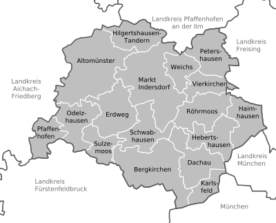
Dachau and the district of Dachau consist of the district town, two markets and 14 municipalities, to which 328 officially named municipal parts belong.
(Residents on December 31, 2019)
  |
Other communities
Former administrative association
|
Municipalities of the district before the territorial reform 1971/78
.jpg)
Until the regional reform from 1971 to 1978, the district of Dachau had 55 municipalities (see list below) on an area of 438.42 km². In 1900 the district still had 56 parishes. The communities Augustenfeld and Etzenhausen were incorporated into the city together with some districts of neighboring communities of the city of Dachau in 1939. Karlsfeld only became an independent municipality in 1939.
In the north the district bordered the district Pfaffenhofen adIlm , in the northeast on the district Freising , in the southeast on the district and the city of Munich , in the south on the district Fürstenfeldbruck , in the south-west on the district Friedberg and in the northwest on the district Aichach .
The communities in the district of Dachau before the community reform from 1971 to 1978. The communities that still exist today are written in bold .
City and community partnerships
- Altomünster : Nagyvenyim ( Hungary ) // friendships with Vadstena ( Sweden ) and Tscherms ( Italy )
- Dachau : Klagenfurt am Wörthersee ( Austria ) // Fondi ( Italy ) // Cultural partnership with the artist colonies Oosterbeek ( Netherlands ) and Tervuren ( Belgium ) // Cooperation in planning with Rosh Haayin ( Israel ) // Friendly relations with Areguá ( Paraguay )
- Haimhausen : Csurgó ( Hungary )
- Hebertshausen : Lókút near Veszprém ( Hungary )
- Karlsfeld : Muro Lucano ( Italy )
- Petershausen : Varennes-en-Argonne ( France )
- Röhrmoos : Taradeau in Provence near Le Luc ( France )
- Schwabhausen : Großschwabhausen in Thuringia ( Germany )
- Vierkirchen : Genazzano ( Italy )
- District cooperation: Dachau - Oświęcim (Auschwitz) (since 2015)
literature
- Wilhelm Liebhart, Gerhard Hanke: The district of Dachau. (= Cultural history of the Dachau region. Volume 1). 1st edition, Museumsverein Dachau eV, Bayernland Verlag, Dachau 1992, ISBN 3-926355-03-4 .
- Pankraz Fried : From old village dishes in the Dachau region. In: Amperland . Volume 1, 1965, pp. 58–60. (zeitschrift-amperland.de) .
Web links
- Hans Schertl: Churches and chapels in the district of Dachau
- Website of the district of Dachau
- Entry on the coat of arms of the district of Dachau in the database of the House of Bavarian History
- Circle.LOOK! - The citizens' magazine in the Dachau region
- Literature from and about the district of Dachau in the catalog of the German National Library
- District of Dachau: Official statistics of the LfStat
- District information "Rural Development"
- Video on YouTube about the district (2016)
- The district of Dachau in Bavarian (Landkroas Dachau)
Individual evidence
- ↑ a b sheet "Data 2", Statistical Report A1200C 202041 Population of the municipalities, districts and administrative districts 1st quarter 2020 (population based on the 2011 census) ( help ).
- ↑ a b c d e f Information about the district | District Office Dachau. Retrieved December 26, 2019 .
- ↑ a b c d e f g Information about the district | District Office Dachau. Retrieved December 26, 2019 .
- ↑ a b c Protected areas | District Office Dachau. Retrieved December 26, 2019 .
- ↑ Natural monuments: local recreation and tourism Dachauer Land. Retrieved December 26, 2019 .
- ↑ The 7KlosterWeg. Regional development association Dachau AGIL Amper-Glonn-Ilm-Land e. V, accessed July 12, 2019 .
- ↑ a b c Alexander Merkel: Climate in Dachau. In: https://de.climate-data.org/ . climate-data.org, accessed on December 22, 2019 .
- ↑ Alexander Merkel: Climate in Dachau. In: https://de.climate-data.org/ . climate-data.org, accessed on December 22, 2019 .
- ↑ Information about the district | District Office Dachau. Retrieved December 26, 2019 .
- ↑ Hans Bauer: The Roman highways between Iller and Salzach according to the Itinerarium Antonini and the Tabula Peutingeriana. New research results on route guidance. Munich 2007, pp. 52f and 103.
- ↑ Scientific review
- ^ Wilhelm Volkert (ed.): Handbook of Bavarian offices, communities and courts 1799–1980 . CH Beck, Munich 1983, ISBN 3-406-09669-7 , p. 443 .
- ^ Wilhelm Volkert (ed.): Handbook of Bavarian offices, communities and courts 1799–1980 . CH Beck, Munich 1983, ISBN 3-406-09669-7 , p. 97 .
- ^ Ordinance on the reorganization of Bavaria into rural districts and independent cities of December 27, 1971
- ↑ https://www.statistik.bayern.de/mam/produkte/veroffnahmungen/statistische_berichte/a1210c_201800.pdf
- ↑ https://www.pv-muenchen.de/fileadmin/Medien_PV/Leistungen/Daten_und_Studien/Gemeindedaten/GDE_Datengrund_2018/GDE__Dachau__Datengrundlagen_2018.pdf
- ↑ https://www.pv-muenchen.de/fileadmin/Medien_PV/Leistungen/Daten_und_Studien/Gemeindedaten/GDE_Datengrund_2018/GDE__Dachau__Datengrundlagen_2018.pdf
- ↑ a b c d e f Melitta Fischer: Kreis.Blick! Ed .: District Office Dachau. No. 6-2019 . Dachau December 2019.
- ↑ https://www.pv-muenchen.de/fileadmin/Medien_PV/Leistungen/Daten_und_Studien/Gemeindedaten/GDE_Datengrund_2018/GDE__Dachau__Datengrundlagen_2018.pdf
- ↑ https://www.pv-muenchen.de/fileadmin/Medien_PV/Leistungen/Daten_und_Studien/Gemeindedaten/GDE_Datengrund_2018/GDE__Dachau__Datengrundlagen_2018.pdf
- ^ District of Dachau Religion , 2011 census
- ↑ More than a thousand church departures in Dachau Exodus Statistics 2019 , accessed on July 6, 2020
- ^ IHK Bavaria: District of Dachau. In: https://standortportal.bayern/de/BayStandorte/Oberbayern/Dachau/landkreis.html . IHK Bayern, April 19, 2019, accessed on April 19, 2019 .
- ↑ IHK Bayern: company locations. In: https://standortportal.bayern/de/BayStandorte/Oberbayern/Dachau/landkreis.html . IHK Bayern, April 18, 2019, accessed on April 18, 2019 .
- ↑ Future Atlas 2016. (No longer available online.) Archived from the original on October 2, 2017 ; accessed on March 23, 2018 .
- ↑ Purchasing power in Germany increased by 1.7 percent in 2017. January 13, 2017, accessed March 26, 2018 .
- ^ A b Malecki: Structural data - Dachauer Land - Munich region for entrepreneurs. Accessed December 31, 2019 (German).
- ↑ https://www.pv-muenchen.de/fileadmin/Medien_PV/Leistungen/Daten_und_Studien/Gemeindedaten/GDE_Datengrund_2018/GDE__Dachau__Datengrundlagen_2018.pdf
- ↑ https://www.pv-muenchen.de/fileadmin/Medien_PV/Leistungen/Daten_und_Studien/Gemeindedaten/GDE_Datengrund_2018/GDE__Dachau__Datengrundlagen_2018.pdf
- ↑ Customs and costumes. D´AMPERTALER DACHAU e. V, accessed April 5, 2019 .
- ↑ ARGE German queens eV: Apple Queen in the Dachau country. ARGE German Kings eV, 2019, accessed on February 27, 2020 .
- ↑ Bavarian State Office for Statistics: Local Election - Results of the person election in the graphic view for Dachau. Bavarian State Office for Statistics, March 15, 2020, accessed on March 24, 2020 .
- ↑ Thomas Radlmaier: Local election in Dachau: District assembly is getting bigger and more colorful. Retrieved March 21, 2020 .
- ↑ Entry on the coat of arms of the Dachau district in the database of the House of Bavarian History , accessed on September 4, 2017 .
- ^ Resolution of the Council of Ministers of September 19, 2016 on the dissolution , accessed on November 6, 2016.
- ↑ Landtag printed matter with the draft law
- ↑ Make three out of one: Odelzhausen administrative community dissolved. In: Aichacher Zeitung. December 1, 2016 (aichacher-zeitung.de , accessed December 9, 2016)
- ↑ Bayer. Law and Ordinance Gazette p. 349/2016.
- ↑ a b page about the district of Dachau on gemeindeververzeichnis.de (accessed on August 25, 2010)
- ^ Michael Rademacher: German administrative history from the unification of the empire in 1871 to the reunification in 1990. Dachau district. (Online material for the dissertation, Osnabrück 2006).
- ↑ BayernViewer of the Bavarian Surveying Administration (accessed on August 25, 2010)
- ^ District cooperation Dachau - Oświęcim (Auschwitz) | District Office Dachau. Retrieved December 26, 2019 .
Districts:
Aichach-Friedberg |
Altötting |
Amberg-Sulzbach |
Ansbach |
Aschaffenburg |
Augsburg |
Bad Kissingen |
Bad Toelz-Wolfratshausen |
Bamberg |
Bayreuth |
Berchtesgadener Land |
Cham |
Coburg |
Dachau |
Deggendorf |
Dillingen on the Danube |
Dingolfing-Landau |
Danube Ries |
Ebersberg |
Eichstätt |
Erding |
Erlangen-Höchstadt |
Forchheim |
Freising |
Freyung-Grafenau |
Fürstenfeldbruck |
Fürth |
Garmisch-Partenkirchen |
Gunzburg |
Hatred Mountains |
Yard |
Kelheim |
Kitzingen |
Kronach |
Kulmbach |
Landsberg am Lech |
Landshut |
Lichtenfels |
Lindau (Lake Constance) |
Main-Spessart |
Miesbach |
Miltenberg |
Mühldorf am Inn |
Munich |
Neuburg-Schrobenhausen |
Neumarkt in the Upper Palatinate |
Neustadt an der Aisch-Bad Windsheim |
Neustadt an der Waldnaab |
Neu-Ulm |
Nuremberg Country |
Oberallgäu |
Ostallgäu |
Passau |
Pfaffenhofen an der Ilm |
Rain |
Regensburg |
Rhön-Grabfeld |
Rosenheim |
Roth |
Rottal-Inn |
Schwandorf |
Schweinfurt |
Starnberg |
Straubing Arch |
Tirschenreuth |
Traunstein |
Unterallgäu |
Weilheim-Schongau |
Weißenburg-Gunzenhausen |
Wunsiedel in the Fichtel Mountains |
Wurzburg
Independent cities:
Amberg |
Ansbach |
Aschaffenburg |
Augsburg |
Bamberg |
Bayreuth |
Coburg |
Erlangen |
Fürth |
Hof (Saale) |
Ingolstadt |
Kaufbeuren |
Kempten (Allgäu) |
Landshut |
Memmingen |
Munich |
Nuremberg |
Passau |
Regensburg |
Rosenheim |
Schwabach |
Schweinfurt |
Straubing |
Willows in the Upper Palatinate |
Wurzburg