
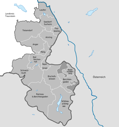
District of Berchtesgadener Land
| coat of arms | Germany map |
|---|---|

|

Coordinates: 47 ° 42 ' N , 12 ° 54' E |
| Basic data | |
| State : | Bavaria |
| Administrative region : | Upper Bavaria |
| Administrative headquarters : | Bad Reichenhall |
| Area : | 839.92 km 2 |
| Residents: | 105,929 (Dec. 31, 2019) |
| Population density : | 126 inhabitants per km 2 |
| License plate : | BGL, BGD, LF , REI |
| Circle key : | 09 1 72 |
| NUTS : | DE215 |
| Circle structure: | 15 municipalities |
| Address of the district administration: |
Salzburger Strasse 64 83435 Bad Reichenhall |
| Website : | |
| District Administrator : | Bernhard Kern ( CSU ) |
| Location of the district of Berchtesgadener Land in Bavaria | |
  |
|
The Berchtesgadener Land is located in the southeast of Upper Bavaria on the border with Austria Salzburg . Bad Reichenhall is the county seat . The district was formed in 1972 as part of the regional reform in Bavaria from the former Berchtesgaden district , part of the former Laufen district and the formerly independent city of Bad Reichenhall. As usual, the district was only named after its administrative seat in Bad Reichenhall, but in 1973 the Bavarian state government decided to rename it to the district sub-region of Berchtesgadener Land, which is still valid today .
With the Watzmann ( 2713 m above sea level ), the district has the highest mountain in Germany, the base of which is entirely on German territory.
geography
location
The district of Berchtesgadener Land forms the southeast corner of Bavaria and Germany. Wedge-shaped ("tail tip of the Bavarian lion" or in a wider sense Austrian : " Little German Corner ") it protrudes into Austria. In the east, south and southwest, the district border is also the state border. The only German neighboring district is Traunstein in the northwest and north.
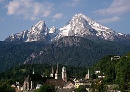
View of Berchtesgaden with the Watzmann in the background
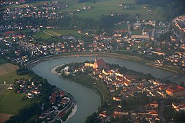
Salzach loop with the Laufens peninsula

View of Bad Reichenhall from the Predigtstuhl


landscape
While the district is slightly hilly in the north, with a few small lakes such as the Abtsdorfer See and the Salzach as the border with Austria, in the south, from Bad Reichenhall with a foothill of the Chiemgau Alps and the adjoining Berchtesgaden Alps, it is alpine or high alpine.
The highest point of the district is the Watzmann- Mittelspitze at 2713 m , the lowest point is the confluence of the Schinderbach in the Salzach in Laufen at 383 m . The difference results in the second highest altitude amplitude of a German district at 2,325 meters , which is only exceeded by the Garmisch-Partenkirchen district .
structure
The district is divided into three geographical regions: the pre-Alpine region with the cities of Laufen and Freilassing , the Alpine region around the large district town of Bad Reichenhall and the high-Alpine region around Berchtesgaden . The district is one of the three only districts in Germany with high alpine regions, along with the Garmisch-Partenkirchen and Oberallgäu districts.
surface
With an area of 840 km², the district of Berchtesgadener Land takes 43rd place among the 71 Bavarian districts; It is in 9th place among the 20 Upper Bavarian districts. It is one of the medium-sized districts in Bavaria.
Protected areas
In the district there are three nature reserves , 20 landscape protection areas , 13 FFH areas and at least 72 designated geotopes (as of August 2016). The largest nature reserve is the Eastern Chiemgau Alps nature reserve established in 1955.
Neighboring counties or districts
The district of Berchtesgadener Land borders in the north and northwest on the district of Traunstein. Otherwise it borders on the Salzburg district of Salzburg-Umgebung , the statutory city of Salzburg and the Hallein district in the east, the St. Johann im Pongau district in the southeast and the Zell am See district in the southwest.
population
As of December 31, 2018, the district had 105,722 inhabitants (around 52 percent of them female). This also makes it one of the medium-sized counties in terms of population. It is 13th in Upper Bavaria and 46th in Bavaria. The population density of 121 inhabitants per square kilometer is well below the Bavarian average. In the course of the war-related “mass migrations” between 1944 and 1950, the number of residents rose unusually across Bavaria. In 1946 35 percent of the population in what is now the rural district were displaced , in 1972 only 25 percent. In 2004, 82 percent of the population were Roman Catholic, 14 percent Evangelical Lutheran, and the proportion of foreigners was about 11 percent.
Population development
From the new formation of the district 1972 to 1987 the population increased slightly. A larger increase was recorded between 1987 and 1991 at 7%. After that, the growth slowed down again. Between 1988 and 2018 the district grew from 91,923 to 105,722 by 13,799 inhabitants or by 15% - after the district of Garmisch-Partenkirchen (11.2%), the second-lowest increase of all Upper Bavarian districts in the period mentioned.
| Population development | ||||||||||||||
|---|---|---|---|---|---|---|---|---|---|---|---|---|---|---|
| year | 1840 | 1900 | 1939 | 1950 | 1961 | 1972 | 1987 | 1991 | 1995 | 2000 | 2005 | 2010 | 2015 | |
| Residents | 27,227 | 36,160 | 59,793 | 84,336 | 81,340 | 88,743 | 90,689 | 96,527 | 98,946 | 99,848 | 102,587 | 102.389 | 103.907 | |
history
Prehistory of the three district regions

The current district area originally belonged entirely to the Baier tribal duchy . From the 13th century, large parts of it alternately came to the politically independent prince archbishopric of Salzburg , while the monastery monastery Berchtesgaden was able to unite increasingly higher jurisdictions and thus also secular power from the end of the 12th century and from 1559 as the prince provostory of Berchtesgaden for the state of Berchtesgaden the same direct empire independence as the prince-archbishop Salzburg achieved.
Historically, this results in a subdivision into three regions for the prehistory of the district:
- in the southern part the "real" Berchtesgadener Land , which gave the district its name, which since 1155 corresponded to the heartland of the Berchtesgaden monastery, which was later elevated to the status of a prince provost and still forms a geographical and socio-cultural region today,
- northwest of it in the middle of the district the city of Bad Reichenhall , which with its surrounding area of the today's communities Bayerisch Gmain and Schneizlreuth consistently belonged to the Baier tribal duchy until 1806 and then to the Kurpfalz-Bavaria and
- in the north the southern part of the Rupertiwinkel, which was formerly ruled by the Prince Archbishopric of Salzburg .
Berchtesgadener Land

adjacent areas of:
red: Prince Archbishopric of Salzburg
yellow: Electorate of Bavaria
The settlement of the high alpine area around today's market Berchtesgaden started with the first clearing activities of Augustinian canons at the beginning of the 12th century. In 1122 a first construction phase or emergency building of the collegiate church was inaugurated in Berchtesgaden . Over the centuries the community was able to develop and, thanks to the rich salt deposits and the salt shelf transferred by Emperor Friedrich Barbarossa , achieved considerable prosperity. The salt deposits, however, repeatedly led to "salt disruptions" or armed conflicts with the Archdiocese of Salzburg . In addition, the provincial regents made far more debts than they had income, so that parts of the area were pledged and from 1393 to 1404 the entire area was incorporated into the Archdiocese of Salzburg . Before and after that, the monastery monastery Berchtesgaden , which rose as a scepter fief to the imperial prelature in 1380, was given more and more rights, including blood jurisdiction, until it was finally raised to the status of the prince provost of Berchtesgaden in 1559 and thereby achieved complete imperial immediacy . It was not until 1803, as part of general secularization in Bavaria , that the prince's provincial, ie spiritual and secular, independence was abolished and the Berchtesgadener Land was initially absorbed into the newly founded Electorate of Salzburg . After the Peace of Pressburg in 1805 it fell to the Austrian Empire , to France under Napoleon in 1809 and finally to the Kingdom of Bavaria in 1810.
Today, the Berchtesgadener Land region, once governed by the prince-prince, with the municipalities of Berchtesgaden , Bischofswiesen , Marktschellenberg , Ramsau bei Berchtesgaden and Schönau am Königssee as well as the municipality-free areas of Eck and Schellenberger Forst is also known as the southern or inner district .
Ducal Bavarian Reichenhall and the surrounding area
As early as 1,800 BC Settled in BC, the region around Reichenhall belonged to the Bavarian tribal duchy since the early Middle Ages. Reichenhall has had its name since the 14th century.
From the early Middle Ages to the 12th century, Reichenhall held a monopoly on brine deposits and salt processing, which gave the place a reputation and the wealth that is said to have given it its name. In 1196, at the instigation of the Archbishop of Salzburg, the city was reduced to rubble and ashes. From the end of the 13th century, a ducal Bavarian regional court with its seat at Gruttenstein Castle , the commissioning of the Berchtesgaden and Hallein salt pans was accompanied by a monopoly break, which gradually almost led to the complete decline of Reichenhall salt processing. At the end of the 15th century, however, the Bavarian Duke bought up all the salt boiling plants, modernized them and thus ensured that the Bavarian salt industry was monopolized by the state. The city and its surroundings were in 1806 finally with the other regions of the Palatinate and Bavaria to the Kingdom of Bavaria over.
Today the formerly ducal or electoral-Palatinate Bavarian sub-region corresponds to the municipalities and cities of Bad Reichenhall , Bayerisch Gmain and Schneizlreuth , of which only Bad Reichenhall and Bayerisch Gmain apply as a region in a joint "Kur- und Verkehrsverein", while Schneizlreuth will apply until 2016 was affiliated with the tourism association of the southern Ruperti angle and has been promoting itself since then. (→ See section: Regional tourism associations )
South Ruperti angle
The Rupertiwinkel area was under the control of the Archdiocese of Salzburg until it was secularized in 1803 . In 1810 it was annexed to the Kingdom of Bavaria together with Salzburg and remained here after 1816, when the Salzburger Land was divided on the Saalach - Salzach line and the eastern part (today: Land Salzburg ) passed into the Austrian Empire . After 1816, the term Rupertiwinkel became naturalized for the cultural landscape that remained in Bavaria , referring to Rupert (690–710), the first bishop of Salzburg , who was venerated as a saint and "Apostle of Bavaria" . Since 2011, the Bavarian State Office for the Environment has had drafts of a reorganization of Bavarian cultural landscapes, which leave the Rupertiwinkel area as described above, as it "can be easily separated from its neighboring areas on the basis of the historical territorial boundary, even if the landscape transitions are fluid are."
Today the southern part of the Rupertiwinkel, which was once ruled by Salzburg, forms the northern district with the municipalities and cities of Ainring , Anger , Freilassing , Laufen , Piding , Saaldorf-Surheim and Teisendorf , which apart from Ainring are also part of an association as the “Berchtesgadener Land adventure region - Rupertiwinkel "apply (let). (→ See section: Regional tourism associations )
Incorporation of the regions within Bavaria from 1810
Kingdom of Bavaria
From 1810, in addition to Reichenhall and its surrounding area, the rest of today's district also belonged completely to the Kingdom of Bavaria and was initially subordinate to the regional courts of Berchtesgaden (1811), Reichenhall (1803), Laufen (1810) and Teisendorf (1811), all of which belonged to the Salzach district until 1817 . After the loss of Salzburg to Austria, the Teisendorf district court was dissolved in 1818 and the district was divided between the Laufen and Reichenhall district courts. After 1817 the Salzachkreis became part of the Isarkkreis , which in 1837 became the administrative district of Upper Bavaria . In 1862 the Berchtesgaden district office was created from the Berchtesgaden and Reichenhall district courts, and the Laufen district office from the Laufen and Tittmoning district courts . The district offices existed until 1939.
The Reichenhall – Traunstein brine pipeline, which had existed since 1619, was extended to Rosenheim in 1810 . The Berchtesgaden - Reichenhall brine pipeline was added in 1817 , as there was a shortage of firewood in the catchment area of the saline of the Berchtesgaden salt mine . Despite the processing in Reichenhall, the saline in Berchtesgaden remained in operation for about 100 years.
As early as 1828 there were first plans for a railway line Munich-Rosenheim-Salzburg which led through today's district. In 1851 the state treaty between Bavaria and Austria for the establishment of the international railway line was concluded and in 1860 the last section between Traunstein and Salzburg - and with it the first railway traffic in the district - was started. This was accompanied by drastic changes, such as the decline of the salt rafting on the Salzach . This changed the importance of the salt rafting town of Laufen in the Rupertiwinkel in favor of today's city of Freilassing , through whose border station and later hub station of the region the routes via Bad Reichenhall to Berchtesgaden and via Laufen to Mühldorf led. As an extension of the Salzburg – Hangender Stein railway, the Berchtesgaden – Hangender Stein railway, electrified from 1908, went into operation in Berchtesgaden in 1907 . This state railway line was shut down in 1938/39 for the construction of a never completed double-track main line to Salzburg. Also, the so-called Königsseer Bahnhof on the former Triftplatz on the edge of the Schönau municipality across from the Berchtesgaden main train station was only able to connect to the Königsseebahn , which ran from Berchtesgaden to Königssee between 1909 and 1966 .
In 1890 Reichenhall was given the title Bad Reichenhall because of its saltwater spa, which was set up in the middle of the 19th century for the treatment of respiratory diseases, and has since been called Bad Reichenhall .
Weimar Republic
From 1929 stood Bad Reichenhall as a circle immediate or in 1939 with the replacement of the designations district and county as a county-level city no longer under the administration of the district office Berchtesgaden.
time of the nationalsocialism
At the beginning of the National Socialist era , Adolf Hitler bought his previous vacation home on Obersalzberg in 1933 and expanded it into the Berghof . Other Nazi leaders settled there and the Obersalzberg Führer's restricted area including the representative Kehlsteinhaus was created . Government affairs were carried out during Hitler's stays at Obersalzberg in the " Small Reich Chancellery " established in 1937 in the Stanggaß district of Bischofswiesen as the second seat of government of the German Reich . The approximately 125 laws and ordinances signed by Hitler here included the Berchtesgaden Agreement requested from the federal state of Austria on February 12, 1938 .
On January 1, 1939, the designation district was introduced as everywhere else in the German Reich. The district offices became the districts of Berchtesgaden and Laufen.
Bad Reichenhall was reintegrated into the Berchtesgaden district in 1940 .
post war period
After the end of the Second World War , from May 1945 the districts of Berchtesgaden and Laufen were occupied by the American occupation troops with new district administrators with unchanged territorial division. On April 20, 1946, the district assemblies were elected by the population. From 1948 to 1972 Bad Reichenhall was again given the status of an independent city .
Territorial reform with formation of the district
During the regional reform in Bavaria on July 1, 1972, the district of Berchtesgaden, the southern part of the district of Laufen and the independent city of Bad Reichenhall were merged to form the new district of Bad Reichenhall . With the ordinance of April 10, 1973 in the Bavarian Law and Ordinance Gazette (GVBl), the district was given its current name on May 1, 1973, "District of Berchtesgadener Land". This renaming "because of the higher level of awareness" was preceded by "heated discussions". The Bavarian State Government justified the renaming as follows: “The landscape name Berchtesgadener Land is linked to the former Stiftsland Berchtesgaden, whose historical significance still has an effect today. (..) The charisma that the name Berchtesgadener Land, which is associated with an extraordinary landscape, justifies naming the new district after this part of the area that characterizes the uniqueness of the entire district. The state government therefore deviates from the principle of naming the district after the place where the district administration is located. "
The district of Laufen had previously filed several violent protests, unsuccessfully, against its division and against the plan to install the district administration of the new district not in the city of Laufen , but in Bad Reichenhall.
The district council had chosen Freilassing as the district town ; however, the Free State of Bavaria determined the city of Bad Reichenhall, which was also elevated to a major district town due to the loss of district freedom . In May 1980, work began in the newly established district office in Bad Reichenhall and, in return, the branch office of the district office in Berchtesgaden was closed. In the former district towns of Berchtesgaden and Laufen, however, various institutions of the district and authorities from other regional authorities remained.
Late agreement on license plates
Analogous to the first name "Landkreis Bad Reichenhall", the license plate REI , which was introduced on July 1, 1956 for the independent city of Bad Reichenhall, was to be adopted for the district created in 1972 after the regional reform . In particular because of violent protests from the former district of Berchtesgaden against the loss of his BGD , his license plate number and that of the district of Laufen ( LF ) remained valid for a few years. The BGL license plate has only been in effect for the entire district since August 1, 1979 .
With the reform of the Vehicle Registration Ordinance (" license plate liberalization ") that came into force on November 1, 2012 , the issue of old license plates is permitted again. After a narrow majority of the district council had spoken out against this possibility in 2013, a district council resolution of July 22, 2016 voted in favor. With the comment "The district identifier 'BGL' remains the standard identifier", the distinctive signs BGD , LF and REI have been issued again as " wish labels " in the district since September 15, 2016 .
Geographical and socio-cultural assignments
The geographical division of the district essentially corresponds to its division into three historically and socio-culturally defined regions: the pre-Alpine region of the southern Rupertiwinkel , which once belonged to the Archdiocese of Salzburg , the Alpine region with the continuously Bavarian town of Bad Reichenhall and its surrounding area, and the high-alpine and eponymous Berchtesgadener Land as since 1155 designated heartland of the monastery monastery Berchtesgaden, which was raised from 1559 to 1803 to the independent prince provost of Berchtesgaden .
| Municipalities and cities in the district are divided into historically and socio-culturally defined regions |
||
|---|---|---|
| Throughout Bavaria | Berchtesgadener Land | South Ruperti angle |
| Bad Reichenhall | Berchtesgaden | Ainring |
| Bayerisch Gmain | Bischofswiesen | Anger |
| Schneizlreuth | Marktschellenberg | Freilassing |
| Ramsau near Berchtesgaden | To run | |
| Schönau a.Königssee | Piding | |
| Corner 1 | Saaldorf-Surheim | |
| Schellenberger Forest 1 | Teisendorf | |
| 1) Municipality-free areas | ||
politics
District administrators
- July 1, 1972–1978: Rudolf Müller ( CSU )
- May 1, 1978–1984: Andreas Birnbacher ( CSU )
- October 6, 1984–2002: Martin Seidl ( CSU )
- May 1, 2002–2020: Georg Grabner ( CSU )
- from May 1, 2020: Bernhard Kern ( CSU )
District councils
The 60 district councils are distributed as follows in the 2020–2026 election period:
| Political party | Seats |
|---|---|
| CSU | 22nd |
| FW | 13 |
| GREEN | 12 |
| SPD | 5 |
| AfD | 3 |
| ÖDP | 2 |
| BLR | 2 |
| FDP | 1 |
The (former) district councilors include: Georg Graßl , Georg Hackl , Michaela Kaniber , Anton Kern , Roland Richter , Franz Xaver Werkstetter (all CSU), Wolfgang Heitmeier (FWG), Bartl Wimmer (GRÜNE), Bärbel Kofler (SPD) and Hermann K. Supporter (FDP).
Euregio
The district of Berchtesgadener Land belongs to the EuRegio Salzburg - Berchtesgadener Land - Traunstein , which was founded in 1995 and whose core areas are the Austrian state of Salzburg and the two Bavarian districts of Berchtesgadener Land and Traunstein. The seat of the communal Euregio is Freilassing .
County partnership
The district also maintains a close relationship with the Polish district of Bełchatowski . On September 13, 2007, the district partnership agreement was signed during a joint special meeting of both district assemblies.
coat of arms
|
|
Blazon : “Above the base of the shield with the Bavarian diamonds are two fields split in gold and blue. In the front golden field is a red armored black lion, on the blue field behind it a golden and a silver key are crossed at an angle. " |
|
Justification of the coat of arms: The golden field reflects the portion of the former district of Laufen, the area of which was under the rule of the Prince Archbishops of Salzburg for a long time, as indicated by the so-called "Salzburg Lion". The crossed keys stand for the area of the former district of Berchtesgaden as well as the former prince-provost of Berchtesgaden as attributes of their patron St. Petrus; the former independent city of Bad Reichenhall is symbolized by the Bavarian diamonds as part of the Wittelsbach heartland.
The district has had this coat of arms since 1973 by decision of the district council and with the consent of the government of Upper Bavaria. |
Communities

Community-free areas
|
Other communities
|
Population figures in brackets as of December 31, 2019
See also:
- Gnotships of the former prince provostship of Berchtesgaden , which are now assigned as districts to the communities of Berchtesgaden , Bischofswiesen , Marktschellenberg , Ramsau and Schönau am Königssee .
- List of places in the district of Berchtesgadener Land
- List of municipalities in the Berchtesgadener Land district
Culture and sights
Visual arts

In addition to Caspar David Friedrich , several other visual artists as (landscape) painters , graphic artists and engravers have chosen Berchtesgaden and its surroundings as their subject over the centuries . This not only resulted in oil paintings , but also graphics that books were used for illustration .
19th century:
- Johann Adam Klein (1792–1875) German painter and engraver of the Biedermeier era and produced, among other things, the etching An artist's journey in Berchtesgaden and the oil painting Berchtesgadener Jahrmarkt .
- Gustav Kraus (1804–1852) Bavarian lithographer of the Biedermeier period.
- Franz Kreuzer (1819–1872) xylograph and landscape painter .
- August Leu (1818–1897) German painter.
- Johann Matthias Ranftl (1804–1854) Austrian painter and graphic artist.
- Heinrich Reinhold (1788–1825) German painter and engraver.
- Johann Gottfried Steffan (1815–1905) one of the most important Swiss landscape painters of the 19th century.
- Franz Xaver von Riedmüller (1829–1901) German landscape painter.
20th century:
- Willy Hanft (1888–1987) German painter.
- Friedrich Ludwig (1895–1970) German expressionist painter who lived in Berchtesgaden for a few years.
- Kurt Tilsner (1909–1989) German watercolourist and oil painter, who lived in Strub from 1979 and whose subject was the Bavarian pre-Alpine landscape ( Berchtesgaden and the surrounding area).
literature
Ludwig Ganghofer had a whole series of his novels set in the Berchtesgadener Land, but the Norwegian writers Jonas Lie and Henrik Ibsen also stayed here and were possibly inspired by the country and its people.
music
Works related to the district
The children's symphony (original title: Berchtoldsgaden-Musik , i.e. Berchtesgaden-Musik) is a chamber composition from the time before the Viennese Classic , and in addition to the usual orchestra, seven typical children's instruments from the Berchtesgaden War are used. The authorship of this work is unclear - the possible composers so far have been Leopold Mozart , his pupil Johann Rainsprechter , Joseph Haydn or his brother Michael Haydn , but according to more recent research, Edmund Angerer seems to have been the actual composer of this work.
Performers from the district
With the Bad Reichenhall Philharmonic , the district has the only professional symphonic orchestra in Upper Bavaria outside of Munich. The Ramsau singers are among the most famous folk music singing groups in Upper Bavaria. Hans Söllner is a nationally known songwriter.
Saga world


Last but not least, the mountains of the Berchtesgadener Land form the background for numerous legends :
- Above all, the Watzmann massif , which has become a landmark, is shrouded in legend. Its nine peaks are interpreted as a royal family that petrified because of their cruelty. The main mountain consisting of three peaks (Hocheck, Mittelspitze, Südspitze) symbolizes the king, the opposite peak symbolizes the queen (Watzmannfrau) and the seven peaks in between symbolize the children.
- The Untersberg opposite, which stretches into neighboring Salzburg , is said to be used as a dwelling after an emperor. Depending on the narrative, Emperor Charlemagne or Friedrich Barbarossa wait here in a death-like sleep, in order to achieve victory with their army for the good at the Last Judgment or when disbelief and violence reach the highest degree . In another version it is said that the emperor slept there until his beard grew seven times around the table base.
- In addition to this sleeping army in Unterberg but also giants (giant Abfaltersbach), called Wild Women who are similar to brownies did a good service, and of course dwarfs (Unterberg Manndln) have lived and worked.
- Not to forget the devil , who leads the wild hunt and not only left his mark on a rock face of the Reiteralpe called Teufelskopf , as well as numerous ghosts who admonish good things on the mountains and as drowned souls in the lakes or invite you to the eerie bowling game.
- There are several legends for the origin of the name Berchtesgaden : According to one, it is derived from the legendary figure Berchta or Perchta , which is also equated with Frau Holle . Another claims that it is due to a certain Berchtold, to whom a mermaid from Königssee showed the way to salt and to the righteous work as a miner in the still existing salt mine in Berchtesgaden .
natural beauties

The Berchtesgaden Alps are the target of several hours of hiking, which for many locals and tourists. In some cases, however, even trained mountaineers can demand highly demanding climbing tours, such as on the Watzmann east face. Several mountain huts, which are managed by the German Alpine Association, serve as a stopover for almost every ascent of a mountain peak .
Museums and exhibitions
technology
- Berchtesgaden salt mine
- Old salt works in Bad Reichenhall
- Graduation house (Bad Reichenhall)
- Hiking along the historic Berchtesgaden - Bad Reichenhall - Traunstein brine pipeline
- Freilassing locomotive world
- Mining Museum Achtal, Teisendorf
history
- Documentation Obersalzberg
- Local history museum Schloss Adelsheim , Berchtesgaden
- Royal Berchtesgaden Castle with deer museum
traffic
The double-track main railway line Munich-Salzburg with two stations in the district of Teisendorf and Freilassing runs through the district . From the Freilassing junction station , the branch line branches off to Berchtesgaden via Bad Reichenhall to the south, and to the north the rail link to Laufen and on to Mühldorf . The Salzburg-Freilassing-Berchtesgaden connection has been integrated into the Salzburg S-Bahn system since 2006 .
The most important long-distance traffic connection of the district is the federal autobahn 8 coming from Munich to Salzburg with the junctions Piding and Neukirchen, the auxiliary junction Anger and the half junction on the Walserberg. In the longitudinal direction from Berchtesgaden to Laufen and from here further north, the B 20 runs as a traffic axis through the district.
The German Alpine Road B 305 leads from Marktschellenberg via Berchtesgaden, Ramsau and Schneizlreuth to the district border near Inzell and represents the shortest connection to the neighboring district of Traunstein for the southern part of the district. Bundesstraße 21 is the shortest connection between the east of the Austrian state of Salzburg and the Pinzgau and Tyrol . The route is therefore an important transit route for the neighboring country of Austria (" small German corner ").
Panorama roads open up the mountain world of the southern district region of Berchtesgadener Land , for example the Roßfeldhöhenringstraße (toll road, peak 1600 m), the Kehlsteinstraße (only bus service, up to 1700 m) or the Hochschwarzeckstraße .
The district is responsible for a network of 17 district roads (see list of district roads in the Berchtesgadener Land district ).
The closest international airport is Salzburg Airport . It is approx. 8.5 km from the BAB 8 entrance to Bad Reichenhall and approx . 13 km from the German-Austrian border at Marktschellenberg . The distance from the Bad Reichenhall driveway to Munich Airport via the motorway connection via BAB 8, BAB 995 , BAB 99 , BAB 9 and BAB 92 is approx. 165 km.
Economy and Infrastructure
In the district, the share of the manufacturing industry including handicrafts in the economic power of the district is around 30 percent. This means that manufacturing companies are the strongest sector in the district, followed by the health industry and trade or wholesale. The income value creation from tourism including the secondary effects resulted in a share of 11.4 percent of the total income value creation of the district. The fact that the tourism share with employment figures of around seven to eight percent of employees is even lower than the percentage income value creation is due to the fact that income in tourism is characterized by small businesses and many small landlords have no employees and provide all the services themselves. There are also significant companies outside the tourist sector in the southern municipalities of Schönau am Königssee , Ramsau bei Berchtesgaden and Berchtesgaden . The added value of income from tourism is here with a share of 30 to 50 percent above the district average.
Manufacturing
Companies in the food industry in the district, such as Milchwerke Berchtesgadener Land in Piding and the confectionery producer Paul Reber ( Mozartkugeln ) in Bad Reichenhall , offer their products in Germany and around the world. Likewise, the Annahütte steelworks in the Hammerau district of Ainring , the oldest still existing steelworks in Europe. It was founded in 1537 and currently (2016) employs around 550 people.
The Berchtesgaden salt mine employs around 100 people. The brine produced there is pumped to the Bad Reichenhaller Saline , where it is boiled into table salt ( Bad Reichenhaller Brandensalz , since 2016 AlpenSalz ).
The wood carvings and chipboard boxes that were once made in the Berchtesgadener Land , the eponymous southern part of the district, as Berchtesgadener War , were in demand all over the world in past centuries, not least as children's toys . Today, however, the Berchtesgadener War is only made for and in the region as a souvenir and Christmas tree decorations in much smaller numbers.
tourism
County-wide marketing
The district is advertised by the marketing company Berchtesgadener Land Tourismus GmbH (BGLT), among other things, with its own website.
After it was established on October 28, 2004 with a partnership agreement between six mayors from all three district regions, the newly founded marketing company Berchtesgadener Land Tourismus , based in Berchtesgaden, started its "operative business" for the first time with the district-wide marketing of tourism or with outdoor advertising for all tourist offers in the district. Since then, the marketing company has been financed and controlled by the shareholders or representatives of the district and the municipalities in the district and the three tourism associations within the Berchtesgadener Land district. Last but not least, the structurally weaker regions within the district in terms of tourism should benefit from the naming and the administrative synergy effects . Noteworthy in this context: while shortly after the marketing company took over the application, references to all three district regions still appear on the home page of the BGLT website, the current home page of the BGLT website and the imprint (as of May 2020) only contain websites to the regions Bad Reichenhall and Berchtesgaden as well as the "economic area Berchtesgadener Land" in a prominent place, the southern Rupertiwinkel is only represented in a sub-section of the region Berchtesgaden. (See also in the next section two municipalities that are not represented in any of the regional special-purpose associations.)
As part of the Bavarian State Development Program (LEP) from 2006, based on the information provided by the four Bavarian tourism associations ( Upper Bavaria-Munich , East Bavaria , Franconia and Allgäu / Bavarian Swabia ) and in cooperation with the Bavarian State Ministry for Economic Affairs and the Bavarian State Statistical Office, all of Bavaria divided into tourist areas or tourist regions. Since then, the district of Berchtesgadener Land has been marked in abbreviated form as "Berchtesgadener Land" by the Bavarian State Office for Statistics on the map of the Bavarian tourist regions published for this purpose . (→ See also in the section: Territorial reform with the creation of the district, the reason for its renaming from 1973 to the district sub-region Berchtesgadener Land .)
Regional tourism associations
Analogous to the three regions of the district ( see section: Prehistory of the three district regions ), after the establishment of the marketing company Berchtesgadener Land Tourismus, the three tourism associations Zweckverband Tourismusregion Berchtesgaden-Königssee ( Berchtesgadener Land ), Kur- und Verkehrsverein Bad Reichenhall / Bayerisch Gmain ( Bad Reichenhall and Bayerisch Gmain ) and Berchtesgadener Land Adventure Region - Rupertiwinkel - eV (southern Rupertiwinkel ) are now mainly responsible for looking after guests on site and for the tourist facilities. The communities of Ainring and Schneizlreuth (since 2016) do not belong to any of the tourism associations or clubs (anymore), but their number of overnight stays is still listed in the district's statistics.
Main offerings and statistical information
Numerous excursion destinations ( see also the sections under: Culture and Sights ) form the basis for tourism as an economic factor, which annually allows over 1.5 million day visitors to visit the district in addition to overnight guests.
As Big Five designated tourist offers focus in the region Berchtesgaden , after which the district is named, are in Berchtesgaden, the Eagle's Nest , the salt mine and the Watzmanntherme and in Schonau am Konigssee Konigssee and Jennerbahn . For winter tourism in Berchtesgadener Land u. a. several ski areas are available, the largest being on Jenner in Schönau am Königssee.
- The “Big Five” of the Berchtesgadener Land region

Jetty of Seelände of King Lake

Gondola the Jennerbahn immediately before the mountain station


In the Bad Reichenhall - Bayerisch Gmain region , the Alte Saline , Rupertustherme and Predigtstuhlbahn are popular attractions for tourists , while in the southern Rupertiwinkel these are Höglwörth Monastery and the city of Laufen .
- Sights in the Bad Reichenhall area and the southern Rupertiwinkel

Mountain station of the Predigtstuhlbahn

View of the Laufen peninsula


With the Bad Reichenhall state bath , the district has the only state bath in Upper Bavaria. The five municipalities of the Berchtesgadener Land region (Berchtesgaden, Schönau am Königssee, Ramsau, Bischofswiesen and Marktschellenberg) are all climatic health resorts and form the only coherent climatic health resort in Germany. Ainring and Piding are recognized as climatic health resorts , the other municipalities in the district are recognized as resorts .
Hotels such as the Axelmannstein and the Kempinski Hotel Berchtesgaden are also well known .
In 2013 the district recorded around 3.5 million overnight stays, over 700,000 guests and had 28,000 beds. In 2013, these key figures generated gross total sales of EUR 505.8 million, which means an increase of 43% since 2005 with the introduction of the district-wide marketing.
Public facilities
The district of Berchtesgadener Land is the owner and / or operator of:
- Koenigssee artificial ice rink
- Abtsdorfer See leisure area
- Media center in Bad Reichenhall
- Berchtesgadener handicrafts ( see also: Berchtesgadener War )
- Berchtesgaden Local History Museum .
Holdings
The district also has major stakes in the following institutions:
- Business development company Berchtesgadener Land
- Residential building in Berchtesgadener Land GmbH
- Kliniken Südostbayern AG
Memberships
The district is a member of:
Web links
- Official website of the district and district office
- Official county-wide tourism website
- Entry on the coat of arms of the Berchtesgadener Land district in the database of the House of Bavarian History
- Literature from and about the district of Berchtesgadener Land in the catalog of the German National Library
- District of Berchtesgadener Land: Official statistics of the LfStat
Individual evidence
- ↑ "Data 2" sheet, Statistical Report A1200C 202041 Population of the municipalities, districts and administrative districts 1st quarter 2020 (population based on the 2011 census) ( help ).
- ↑ a b c on § 1 No. 2 - District of Berchtesgadener Land , paragraph: 2. Name of the district in Bavarian Landtag · 7th electoral term PRINTED MATERIAL 7/3863 of February 14, 1973, see p. 4 and 5, PDF file with 26 pages (2.1 MB), online at bayern.landtag.de
- ↑ Ulrich Ammon, Hans Bickel, Jakob Ebner a. a .: German variant dictionary. Walter de Gruyter, Berlin 2004, ISBN 3-1101-6575-9 , p. 197.
- ^ History of the district of Berchtesgadener Land with reference to the three geographical regions of the district, online on the homepage of the district office of the district of Berchtesgadener Land at lra-bgl.de
- ↑ Green List, Nature Reserves , accessed on January 1, 2015.
- ↑ a b Hellmut Schöner (ed.): The Berchtesgadener Land through the ages - supplementary volume 1 . 1982. p. 331
- ↑ a b Bavarian State Office for Statistics - Table 12411-001: Update of the population: Population: municipalities, reference dates (last 6) from July 2016 (population figures based on the 2011 census)
- ↑ a b Berchtesgadener Land Tourismus GmbH: The history of the district of Berchtesgadener Land ( Memento from July 13, 2016 in the Internet Archive ): “The 'district of Berchtesgadener Land' forms a historical, cultural and economic unit; all three parts - the actual 'Berchtesgadener Land' (in the narrower sense of the former sovereignty of the prince-provost of Berchtesgaden), the city of Bad Reichenhall and the land around Laufen - stood in the early Middle Ages over the centuries until the beginning of the 19th century Tension between the Archdiocese of Salzburg and the Duchy of Bavaria, who both claimed the richness of salt in the area. ” - online at berchtesgadener-land.com
- ↑ Kaiserl. Decret, in Salzburg and Berchtesgadischen Salzirrungen - Prague, November 20, 1591 . In: Johann Georg von Lori : Collection of the Baierischen Bergrechts: with an introduction to the Baierische Bergrechtsgeschichte. Franz Lorenz Richter, Munich 1764, p. 345 ( online via Google Books ).
- ↑ a b c stadt-bad-reichenhall.de see town history - chronicle. Brief outline of Bad Reichenhall's history
- ↑ The word part is rich according to city history - chronicle. Brief outline of Bad Reichenhall's history relating to the wealth that was acquired through salt. Etymologically more plausible, however, is the assumption that the rich in the place name refers to the amount of salt itself. The larger site of salt production is geographically on the Austrian side of the mountain range , opposite the hallin , the 'small salt production', today the city of Hallein (although the relationship soon reversed over time). See Ingo Reiffenstein : Historisch-Etymologisches Lexikon der Salzburger Ortnames (HELSON) . Volume 2 - Tennengau, Edition Tandem, Salzburg 2017 [= 33rd supplementary volume to the communications of the Society for Salzburg Regional Studies ], ISBN 978-3-902932-74-7 , p. 32 ff.
- ↑ Bavarian State Office for the Environment : Draft of a cultural landscape structure of Bavaria as a contribution to biodiversity - 60 Rupertiwinkel (status: 2011), online at lfu.bayern.de
- ^ Wilhelm Volkert (ed.): Handbook of Bavarian offices, communities and courts 1799–1980 . CH Beck, Munich 1983, ISBN 3-406-09669-7 , p. 97 .
- ↑ Michael Rademacher: Landkreis Laufen ( Memento from September 3, 2017 in the Internet Archive ), online at verwaltungsgeschichte.de
- ↑ see p. 30 § 1 in the ordinance determining the names of the districts and the seats of the district administrations of April 10, 1973 in: Bayerisches Gesetz- und Verordnungsblatt No. 9 - Munich, April 30, 1973 . PDF file with 72 pages (61.2 MB), online at Verkuendung-bayern.de
- ↑ a b See p. 1097 in: Walter Brugger , Heinz Dopsch , Peter F. Kramml (Ed.): History of Berchtesgaden. Volume III / 2 - Berchtesgaden in the Kingdom and Free State of Bavaria from 1810 to the present . ISBN 978-3-927957-21-3 .
- ↑ Schools in Salzburg: Home with a history and a future , PDF file, on the district of Laufen and its division, see page 85 of 130 pages, online at schulen.salzburg.at
- ↑ a b Hellmut Beautiful (ed.): Berchtesgaden in the course of time - Supplement I . 1982. p. 327.
- ↑ Hellmut Beautiful (Ed.): Berchtesgaden through the ages - Supplementary Volume I . 1982. p. 327. Under the sign that BGD was a kind of trademark and tourist advertisement for Berchtesgaden, numerous members of the state and Bundestag as well as the transport ministries in Bonn and Munich were used to protest against the change in the number.
- ↑ Michael Hudelist: “BGD” is back , in the Berchtesgadener Anzeiger of July 23, 2016, online at berchtesgadener-anzeiger.de
- ↑ Reintroduction of the old REI, BGD and LF license plates , announcement by the Berchtesgadener Land district office of July 28, 2016, online at lra-bgl.de
- ↑ District Council runoff election - 2020 municipal elections in the Berchtesgadener Land district - overall result. Accessed March 31, 2020 .
- ↑ Local election on March 15th, 2020 Election of the city councils in the independent cities - Preliminary results
- ↑ Entry on the coat of arms of the Berchtesgadener Land district in the database of the House of Bavarian History , accessed on September 2, 2017 .
- ↑ "Data 2" sheet, Statistical Report A1200C 202041 Population of the municipalities, districts and administrative districts 1st quarter 2020 (population based on the 2011 census) ( help ).
- ↑ Hellmut Schöner (ed.): Berchtesgaden in the course of time . 1973. s. Pp. 168,169
- ↑ A source on the world of legends: Legends and legends about the Berchtesgadener Land by Gisela Schinzel-Penth , Ambro Lacus Verlag, Andechs 1982, ISBN 3-921445-27-2
- ↑ a b c d 2014 annual report of the Berchtesgadener Land mbH business development agency in the section Tourism image shapes sustainable economy on p. 9 of 44 pages
- ↑ Annahütte steelworks ?? a company with history , website of the Annahütte steelworks , online at annahuette.com
- ↑ your competence? The future of tomorrow , website of the Annahütte steelworks, online at annahuette.com
- ↑ History of the Bad Reichenhaller brand , online at bad-reichenhaller.de
- ↑ a b Imprint of the website of Berchtesgadener Land Tourismus GmbH (BGLT) , online at berchtesgadener-land.com
- ↑ a b 10 years of Berchtesgadener Land Tourismus GmbH - key figures and facts ( memento of July 2, 2018 in the Internet Archive ), commemorative publication as a PDF file, with the sections BGLT structure p. 6 and BGLT tasks p. 7 of 36 pages, online at berchtesgadener-land.com
- ↑ Entries in the commercial register of Berchtesgadener Land Tourismus GmbH including a passage on the shareholders, online at online-handelsregister.de
- ↑ a b oete.de ( Memento from April 27, 2014 in the Internet Archive ) For “Berchtesgadener Land Tourismus GmbH” see PDF documentation of Ecological Tourism in Europe p. 63 f. of 117 pages
- ↑ oete.de ( Memento from April 27, 2014 in the Internet Archive ) On “Berchtesgadener Land Tourismus GmbH”: “The naming and the location in Berchtesgaden underline the focus of the Berchtesgaden region with its southern communities. The northern areas hope that, as municipalities with weaker tourism, they will benefit from joint marketing of the district. ” See PDF documentation of ecological tourism in Europe, p. 66 and 67 of 117 pages
- ↑ Berchtesgadener Land Tourismus GmbH (BGLT) ( Memento from November 28, 2005 in the Internet Archive ), homepage of the Internet website at the end of 2005, online at berchtesgadener-land.com
- ↑ a b Der Rupertiwinkel - The country in front of the Berchtesgaden mountains , online at berchtesgaden.de ; Strangely, the Berchtesgadener Land Adventure Region Tourism Association - Rupertiwinkel - eV does not have its own website. In October 2018, the district assembly voted on whether the district would withdraw as a shareholder from this association - the majority of the district assembly then decided to remain, see district does not leave the adventure region , notification from October 31, 2018, online at bgland24.de
- ^ Ordinance on the Bavarian State Development Program of August 8, 2006 , online at oedp-bayern.de
- ↑ Bavarian State Office for Statistics : Tourism regions in Bavaria , PDF file, status: January 1, 2010, online at statistik.bayern.de
- ↑ Kur & Verkehrsverein Bad Reichenhall , online at kvv-badreichenhall.de
- ↑ Schneizlreuth - Discussions about "Erlebnisregion BGL" , report from March 10th 2017 in the Passauer Neue Presse , online at pnp.de - in retrospect , in contradiction to the history of the three district regions, Schneizlreuth's exit from the special purpose association Erlebnisregion Berchtesgadener Land - Rupertiwinkel - eV reported, although the community is located southwest of Bad Reichenhall and was also historically connected to the city as its immediate “surrounding area”.
- ↑ oete.de ( Memento of April 27, 2014 in the Internet Archive ) PDF documentation of ecological tourism in Europe pp. 61 f., 64 f., 70 f.
- ↑ Bayerische Staatsbäder - Bad Reichenhall , online at bayerische-staatsbaeder.de
- ↑ Bäderland Germany - Berchtesgadener Land , online at baederkalender.de
- ↑ Berchtesgadener Land Tourismus GmbH: 10 years of Berchtesgadener Land Tourismus GmbH - key figures and facts , Festschrift (PDF), Berchtesgaden 2014, accessed on December 17, 2017, p. 12, online at www.berchtesgadener-land.com .
- ↑ 10 years of Berchtesgadener Land Tourismus GmbH - key figures and facts ( memento of July 2, 2018 in the Internet Archive ), commemorative publication as a PDF file, with the section Tourism as an economic factor on p. 20 of 36 pages, online at berchtesgadener-land.com
- ↑ About us , online at berchtesgadener-handwerkskunst.de
- ↑ reported in Official Gazette No. 51 of December 22, 2015
Districts:
Aichach-Friedberg |
Altötting |
Amberg-Sulzbach |
Ansbach |
Aschaffenburg |
Augsburg |
Bad Kissingen |
Bad Toelz-Wolfratshausen |
Bamberg |
Bayreuth |
Berchtesgadener Land |
Cham |
Coburg |
Dachau |
Deggendorf |
Dillingen on the Danube |
Dingolfing-Landau |
Danube Ries |
Ebersberg |
Eichstätt |
Erding |
Erlangen-Höchstadt |
Forchheim |
Freising |
Freyung-Grafenau |
Fürstenfeldbruck |
Fürth |
Garmisch-Partenkirchen |
Gunzburg |
Hatred Mountains |
Yard |
Kelheim |
Kitzingen |
Kronach |
Kulmbach |
Landsberg am Lech |
Landshut |
Lichtenfels |
Lindau (Lake Constance) |
Main-Spessart |
Miesbach |
Miltenberg |
Mühldorf am Inn |
Munich |
Neuburg-Schrobenhausen |
Neumarkt in the Upper Palatinate |
Neustadt an der Aisch-Bad Windsheim |
Neustadt an der Waldnaab |
Neu-Ulm |
Nuremberg Country |
Oberallgäu |
Ostallgäu |
Passau |
Pfaffenhofen an der Ilm |
Rain |
Regensburg |
Rhön-Grabfeld |
Rosenheim |
Roth |
Rottal-Inn |
Schwandorf |
Schweinfurt |
Starnberg |
Straubing Arch |
Tirschenreuth |
Traunstein |
Unterallgäu |
Weilheim-Schongau |
Weißenburg-Gunzenhausen |
Wunsiedel in the Fichtel Mountains |
Wurzburg
Independent cities:
Amberg |
Ansbach |
Aschaffenburg |
Augsburg |
Bamberg |
Bayreuth |
Coburg |
Erlangen |
Fürth |
Hof (Saale) |
Ingolstadt |
Kaufbeuren |
Kempten (Allgäu) |
Landshut |
Memmingen |
Munich |
Nuremberg |
Passau |
Regensburg |
Rosenheim |
Schwabach |
Schweinfurt |
Straubing |
Willows in the Upper Palatinate |
Wurzburg