
Montfaucon (Doubs)
| Montfaucon | ||
|---|---|---|

|
|
|
| region | Bourgogne-Franche-Comté | |
| Department | Doubs | |
| Arrondissement | Besançon | |
| Canton | Besançon-5 | |
| Community association | Grand Besançon | |
| Coordinates | 47 ° 14 ' N , 6 ° 5' E | |
| height | 240-614 m | |
| surface | 7.25 km 2 | |
| Residents | 1,550 (January 1, 2017) | |
| Population density | 214 inhabitants / km 2 | |
| Post Code | 25660 | |
| INSEE code | 25395 | |
| Website | www.montfaucon25.fr | |
 Mairie Montfaucon |
||

Montfaucon is a French commune with 1,550 inhabitants (as of January 1 2017) in Doubs in the region Bourgogne Franche-Comté .
geography
Montfaucon is located at 510 m , about four kilometers east of the city of Besançon (as the crow flies). The village extends in the western Jura at a promising location on the Jura ridge (Côte) between the deeply cut Doubstal in the northwest and the so-called first Jura plateau (basin of Saône) in the southeast, on the southern roof of the heights of Montfaucon.
The area of the 7.25 km² large municipality covers a section of the western French Jura. The north-western border runs along the Doubs, which flows here deeply between the Mont de Brégille and the Côte to the south-west. From the course of the river, the community area extends southeast over a steep slope to the Jura ridge, which, in geological and tectonic terms, forms an anticline of the Jura. The steep slope is divided into various protrusions by several short erosion channels. It is criss-crossed by ledges in some places (Roches d'Arbois climbing rock). At 614 m, the highest point in Montfaucon is reached at Fort de Montfaucon. The wooded southern slope of the Jura ridge also belongs to Montfaucon. The border here runs along the foot of the chain on the northern edge of the extensive marshland Marais de Saône , which occupies part of the first Jura plateau.
The hamlet of La Malate ( 250 m ) in the Doubstal belongs to Montfaucon . Neighboring communities of Montfaucon are Chalèze in the north, Gennes in the east, Saône and Morre in the south and Besançon and Chalezeule in the west.
history
The local history of Montfaucon begins around the middle of the 11th century when Béraud de Montfaucon, a vassal of the Count of Burgundy and the Archbishop of Besançon, settled here. However, the location of the first wooden castle is unknown. The lords of Montfaucon quickly rose to become one of the most important noble families of Franche-Comté. By marriage, Richard de Montfaucon became Count of Montbéliard in 1148, which lasted until the line was extinguished at the end of the 14th century. Probably in the middle of the 13th century, the castle of Montfaucon was moved to its present location on a ledge above the Doubstal. In addition, the fortified town of Montfaucon developed, which had had a parish church since 1311. In 1415, the rule of Montfaucon passed through marriage to Louis von Chalon-Arlay from the House of Orange, which held the rule until the French Revolution . After the invasion of Ludwig XI. in the Franche-Comté the castle was partially destroyed in 1477.
At the beginning of the 16th century, the first individual farms were built in the area of today's village center (called Montfaucon-les-Granges). The Thirty Years' War led to the decline of the castle and the Burgfleckens. Together with Franche-Comté , the village finally came to France with the Peace of Nijmegen in 1678. The former Montfaucon-les-Granges developed into the new town center. When the church of Vieux-Montfaucon became dilapidated in the middle of the 18th century, it was decided to build a new church in the center of the new town.
For a long time dominated by agriculture, Montfaucon developed into a garrison location after the Franco-German War . At the height of Montfaucon, Fort Vieux was built in 1871 and Fort Neuf (today Fort de Montfaucon) from 1874 to 1878 as part of the fortress system around Besançon. At the end of the 19th century the village population began to migrate to Besançon, which was accelerated in 1905 with the relocation of the 350-strong garrison to Besançon.
Attractions
The Notre-Dame de la Nativité church was built from 1775 to 1785 in the classical style. The ruins of the former Château de Montfaucon from the 13th century have been preserved. The fortifications of Fort Vieux and Fort de Montfaucon are at the top. The location of the transmission tower offers a good view of the Doubstal and the near and far surroundings. Few remains of a water pipe that led from Arcier to Vesontio (Besançon) are reminiscent of Roman times.

Notre-Dame de la Nativité church
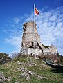
Tower ruins of the Château de Montfaucon

Montfaucon transmission tower


population
| Population development | |
|---|---|
| year | Residents |
| 1962 | 355 |
| 1968 | 510 |
| 1975 | 946 |
| 1982 | 1055 |
| 1990 | 1262 |
| 1999 | 1372 |
| 2016 | 1527 |
With 1550 inhabitants (as of January 1, 2017), Montfaucon is one of the smaller communities in the Doubs department. After the population in the first half of the 20th century had always been in the range between 250 and 340 people, a striking population growth has been recorded since the beginning of the 1960s. Since then, the population has quadrupled.
Economy and Infrastructure
Until well into the 20th century, Montfaucon was a village dominated by agriculture (arable farming, fruit growing and cattle breeding). In addition, there are now some local small businesses. In the meantime, the village has also turned into a residential community. Many workers are therefore commuters who go to work in the Besançon agglomeration.
Although the village is away from the larger thoroughfares, it is still well developed in terms of traffic. The main access is from the Trou du Loup pass on the main road N57, which leads from Besançon to Pontarlier . The closest connection to the A36 motorway is around 14 kilometers away. Other road connections exist with Fontain, Saône and Bouclans.