
Brenner Pass
| Brenner / Passo del Brennero | |||
|---|---|---|---|
 The Brenner Pass seen from the north |
|||
| Compass direction | North | south | |
| Pass height | 1370 m above sea level A. | ||
| region | State of Tyrol , Austria | Province of South Tyrol , Italy | |
| Watershed | Sill | Eisack | |
| Valley locations | Gries on the burner | Sterzing | |
| expansion |
|
|
|
| Built | Altstrasse (Autobahn: 1963) | ||
| Mountains | Stubai Alps / Zillertal Alps | ||
| map | |||
|
|||
| Coordinates | 47 ° 0 '12 " N , 11 ° 30' 27" E | ||

The Brenner Pass , shortly burner ( Italian Passo del Brennero or short Brennero ), is a border pass in the Eastern Alps between the Austrian state Tyrol and to Italy belonging to the Autonomous Province of Bolzano - South Tyrol .
The burner is a 1370 m above sea level. A. high crossing in the eastern main ridge of the Alps . It connects the Stubai Alps in the west with the Zillertal Alps in the east and separates the South and North Tyrolean sections of the Wipptal from each other. Together with St. Gotthard , Simplon and Mont Cenis, the pass is one of the four most important routes for Alpine transit , and the most widely used for road traffic. It is also the busiest connection between Austria and Italy. In contrast to the Swiss passports, the focus here is not on the railways , but on road traffic .
Since the Treaty of Saint-Germain came into force in 1920, the border between Italy and Austria has run across the Brenner .
Surname
In the older literature, when discussing the origin of the name Brenner, reference is often made to the Alpine people of the Breonen or the Celtic military leader Brennus . However, neither from antiquity nor from the early Middle Ages has a direct name for the Brenner passed down, but terms such as per alpes Rhaeticas or - literally in the Carolingian Divisio Regnorum from 806 - per alpes Noricas (route through the Rhaetian or Noric Alps ). Another derivation arises from the assumption that one of the trade routes (the Amber Road ) for amber from the Baltic Sea to the Nile could have led via the Brenner since the Bronze Age and that the "Brennstein" thus gave its name. However, all of these links are considered implausible in recent name research.
The much more likely etymology of the name goes back to the late Middle Ages . In 1288 the farm of a Prennerius de Mittenwalde is documented (today's pass village of Brenner was still called Mittenwald at that time ), in 1299 the man who works at the farm is called Chunradus Prenner de Mittenwalde . Prenner can be interpreted as a name for a man who clears and burns . In 1328 the top of the pass was explicitly mentioned for the first time as if the Prenner . In 1455 the pass was referred to as the Prynner in Brixen records . At the end of the Middle Ages and at the beginning of the modern age, the Middle or Neo-Latin name Mons Brennus appears .
geography

The Brenner and the mountain ranges that run from it to the east and west form the watershed between the Sill and the Eisack - and thus the main watershed between the Adriatic and the Black Sea . Regionally, this watershed separates the catchment areas of the great northern Alpine rivers Inn and Danube from the area south of the main Alpine ridge ( South Tyrol and Upper Italy ), which is mainly drained by the Etsch ( Adige in Italian ).
In the West, the pass is from the Stubai Alps counted Saddle Mountain ( 2115 m dominates). To the east of the rises Zillertal Alps projected Wolfendorn ( 2776 m ). The two valleys of the Sill and Eisack that lead to the north and south of the Brenner Pass are collectively called the Wipptal .
On the Brenner, the state border is not exactly based on the natural watershed, but runs a little north of it. At the summit there is the community for burner belonging (South Tyrol, Italy) village burners , and on the Austrian side the the municipality Gries am Brenner belonging rotting Brenner (even torch ).
Brenner axis
The Brenner route is the main crossing between the two halves of Tyrol and is of great importance for international traffic.
The transport connection includes:
- a four-lane motorway with toll , the Brenner motorway , which was built from 1959 to 1975 , today a section of the European route 45 (in Austria called the " Brenner motorway " A 13, in Italy as the "Autostrada del Brennero" A 22 ),
- the " Brennerstraße " B 182 (old pass road) on the Austrian side and SS 12 on the Italian side,
- a railway line , the Brennerbahn with the Brenner station on the top of the pass,
- the Eisack Valley cycle route on the Italian side, which is connected to the Italian long-distance cycle network .
The Brenner Route connects Munich (519 m) via Innsbruck (574 m) and Bozen (262 m) with the Po Valley . The northern and southern approaches to the Brenner pass through the main valleys of the Alps: in the north through the Inn Valley , in the south through the Adige Valley .
In addition, an approximately 55 km long railway tunnel, the Brenner Base Tunnel (BBT), will be built between Innsbruck and Franzensfeste by 2027 . The aim is to largely shift transit freight traffic from road to rail.
history
Antiquity
When the surrounding areas of Breonen and Genaunen were populated (from the 5th century BC), routes across the Brenner were mainly used for local traffic.
In the year 15 BC A Roman army headed by Drusus moved northwards over the main Alpine ridge against weak resistance from the local tribes, where it united (presumably near today's Augsburg-Oberhausen ) with the troops coming from Gaul via the Lake Constance region under Drusus' brother Tiberius . While Drusus himself crossed the mountains over the Reschenpass , his military leaders Publius Silius Nerva to the west of it through the Lower Engadine and Lucius Calpurnius Piso to the east of it over the Brenner to the north pushed in parallel in a pincer movement . The Greek geographer and historian Strabo reports that, particularly south of the Brenner, the long-established population was in part completely exterminated or enslaved. In the period that followed, the region was inhabited by a few Roman settlers, but Noric settlers also settled in the Eisack Valley and its many side valleys. The native tribes continued to inhabit the barren side valleys. The Breonen are mentioned in documents until the 9th century, before they were completely absorbed by the Bavarian population.
The pass was an important link between Italy and the province of Raetia in Roman times . Between 195 and 215, Emperor Septimius Severus had the old, unpaved paths expanded and a paved road built, which was relatively narrow and sometimes very steep. This Roman road , known today as Via Raetia , led from Verona and Tridentum ( Trient ) over the pass to Veldidena (today Innsbruck ) and from there over the Seefelder Sattel to Augusta Vindelicorum ( Augsburg ). In the year 268 the Alamanni advanced over the Brenner to Italy before they were defeated in November of the same year in the battle at Lacus Benacus ( Lake Garda ).
middle Ages
Due to the good construction and substructure, the trade route remained as part of the Via Imperii until the Middle Ages . The route over the Brenner Pass was significantly upgraded from around 900, when eastern northern Italy was devastated by the Hungarian invasions and the Brenner route was one of the few safe traffic routes. One of the sponsors of this traffic route was Bishop Zacharias von Säben (890–907). In 952, King Otto I established the margraviate of Verona to militarily secure the Brenner Pass. In the Middle Ages it was the most popular alpine pass. The increasing decay made transport with pack animals on many sections only possible. The narrow gorge of the Eisack north of Bozen remained completely pathless; Travelers and transport had to the 14th century south of Bressanone on the Ritten dodge massif. In 1314, the Bozen merchant Heinrich Kunter was given the right to create a mule track through the gorge from Bozen to Klausen and to levy road tolls (hence the name of this section is also called Kunterschlucht). As early as 1430, over 90% of long-distance trade between Augsburg and Venice - 6500 freight wagons per year - was carried out on the Brenner route, also known as the “lower road”.
In 1480, the Kuntersweg was extended to a driveway, and gunpowder was used for the first time to blast rocks. The company was founded in 1485 a trading post of Fugger in Innsbruck and the relocation of the major markets of Bolzano from 1487 to Mittenwald because of disputes between Duke Sigismund the Wealthy and Venice let the traffic through the Brenner continue to increase.
Modern times
In 1522 a postal rate was set up via the Brenner Pass.
Like all other Alpine passes, this one was also dangerous: floods in summer and avalanches in winter made crossing the Alps unsafe. It was not until 1777 that Empress Maria Theresa had the pass expanded. In September 1786, Johann Wolfgang von Goethe passed the Brenner Pass on his trip to Italy .
In 1867, after only three years of construction, the Brennerbahn was opened as the first railway line over the main Alpine ridge.

Since the Treaty of Saint-Germain came into force in 1920, the state border between Austria and Italy has run on the Brenner Pass. On October 13, 1921, the Italian King Viktor Emanuel III visited and his wife Elena of Montenegro visited the new northern border, where they attended the unveiling of the new landmark. In the mid-1930s, the construction of military roads and fortifications of the Italian Vallo Alpino began on the Brenner Pass and its surroundings , which is still visible today in numerous remains. These facilities were expanded after the annexation of Austria to the German Reich in 1938, before work was stopped in mid-1942 due to diplomatic tensions between Berlin and Rome. On March 18 and October 4, 1940 and June 2, 1941, the pass moved into the focus of the international public: the two dictators Adolf Hitler and Benito Mussolini met at the Brenner train station for consultations in the context of the Second World War that they unleashed . In 1944/45 the pass was hit by heavy Allied bombing.
In 1959 the construction of the Europabrücke began - and with it the implementation of the pioneering Brenner motorway project . On April 5, 1971, the pass could be crossed on the motorway for the first time.
On April 5, 1975, an avalanche buried the Brenner Pass on the South Tyrolean side. Six people died in their cars. The pass was impassable for two weeks. Only then were avalanche protection structures built on the slopes .
The 1990s brought radical changes to the Brenner. With the end of the Cold War and the settlement of the South Tyrolean conflict , military interest in the Italian northern border disappeared. Thanks to Austria joining the EU in 1995, the customs stations became superfluous. The Schengen Agreement also put an end to the systematic border controls on April 1, 1998, which was celebrated in a ceremony in the presence of Interior Ministers Karl Schlögl and Giorgio Napolitano as well as Governors Wendelin Weingartner and Luis Durnwalder . All these developments led to a greatly reduced space requirement at the border town, which resulted in extensive vacancies .
In the course of the refugee crisis in Europe , identity controls were partially resumed in September 2015.
Trivia
The official song of the German national soccer team for the 1990 World Cup in Italy, created in collaboration with Udo Jürgens, was called We are already on the Brenner . Germany became world champions at the tournament.
photos

Route of the Eisack Valley Cycle Route on the former above-ground track bed of the Brenner Railway

North ramp between Gries am Brenner and the summit of the pass with the A 13, the Sill and the state road B 182
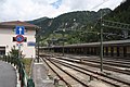
“Brennero / Brenner” station at the top of the pass
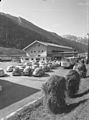
Burner customs office in 1965

Customs border between Italy and Austria in 1978


literature
- Peter Anreiter : The burner . In: onenological information / NI 109/110 (2017), pp. 9–29 ( PDF, 364 kB )
- Engelbert Auckenthaler: History of the farms and families of the uppermost Eisack valley (Brenner, Gossensass, Pflersch). Wagner University Press, Innsbruck 1953.
- Steffan Bruns: Alpine passes - history of the alpine pass crossings . From the Inn to Lake Garda. 1st edition. tape 3 . L. Staackmann Verlag KG, Munich 2010, ISBN 978-3-88675-273-7 , p. 122-149 .
- Günther Ennemoser: Gossensass, Brenner, Pflersch. Publishing house Athesia, Bozen 1984, ISBN 88-7014-344-9 .
- Christiane Ganner (Red.): Verona-Tirol. Art and economy on the Brennerweg (899–1516) (= Runkelsteiner writings on cultural history 7). Athesia, Bozen 2015, ISBN 978-88-6839-093-8 .
- Hans Kramer: The Brenner Settlement since 1918 . In: Publications of the Tiroler Landesmuseum Ferdinandeum . tape 26/29, 1946-1949 , pp. 537-554 ( PDF on ZOBODAT ).
- Wittfrida Mitterer, Board of Trustees for Technical Cultural Assets (ed.): [Border] Brenner Pass: Building Glossary. Athesia, Bozen 2005, ISBN 88-8266-327-2 .
- Alois Trenkwalder: Brenner. Mountain village and alpine pass - Brennero. Storia di un paesino e di un valico internazionale . Brenner 1999 ( online ).
- Hermann Wopfner : The settlement of the high mountain valleys, represented by the settlement history of the Brenner area. In: Journal of the Austrian Alpine Club. 51, 1920.
Web links
- David Klaubert: Brenner. The village at the top of the pass. faz.net , November 5, 2011, accessed January 24, 2013 .
Individual evidence
- ↑ Martin Bitschnau , Hannes Obermair : Tiroler Urkundenbuch, II. Department: The documents on the history of the Inn, Eisack and Pustertal valleys. Vol. 1: Up to the year 1140 . Universitätsverlag Wagner, Innsbruck 2009, ISBN 978-3-7030-0469-8 , p. 51-52 No. 73 .
- ↑ Gisela Graichen, Alexander Hesse: The Amber Road: Hidden trade routes between the Baltic Sea and the Nile. Rowohlt Verlag, 2012, ISBN 3644022410 , ISBN 9783644022416 ( Chapter "About the burner?" Online ).
- ^ J. Schmidkontz: Ortskunde and place name research in the service of linguistics and history: I. Investigations into German place names, following the interpretation of the name Kissingen. M. Niemeyer, 1895, original: University of California. P. 70
- ↑ Peter Anreiter : The burner . In: onenological information / NI 109/110 (2017), pp. 9–29 ( PDF, 364 kB ).
- ^ Egon Kühebacher : The place names of South Tyrol and their history. The historically grown names of the municipality, parliamentary groups and hamlets . Athesia, Bozen 1995, ISBN 88-7014-634-0 , p. 59 .
- ^ Acta Cusana. Sources on the life story of Nikolaus von Kues . Eds. Johannes Helmrath and Thomas Woelki. Volume II, Delivery 3, Meiner, Hamburg 2017, p. 899, no. 4306.
- ^ Hans Kramer: The Brenner Settlement since 1918 . In: Publications of the Tiroler Landesmuseum Ferdinandeum . tape 26/29, 1946-1949 , pp. 537-554 ( PDF on ZOBODAT ).
- ^ Alois Trenkwalder: Brenner. Mountain village and alpine pass - Brennero. Storia di un paesino e di un valico internazionale . Brenner 1999, p. 77 ( online ).
- ↑ Mario Bloier: Rural settlement in Roman times and typology of the villa rustica. In: Archeology in the Dachauer Land 2008–2010. Archaeological Association for the City and District of Dachau, Dachau, 2011, pp. 61–84 ( academia.edu ).
- ↑ The Roman invasion of Tyrol in 15 BC Chr . On Geschichte Tirol , a website of the association fontes historiae - sources of history.
- ↑ Cf. Mark Mersiowsky : Hungarian trains in the early medieval Alpine region. In: Verona-Tirol. Art and economy on the Brennerweg (899–1516) (= Runkelsteiner writings on cultural history 7). Bolzano 2015, ISBN 978-88-6839-093-8 , pp. 15-48.
- ^ Martin Kluger: The Fugger in Augsburg. ISBN 978-3-939645-63-4 , p. 13 ( context-mv.de PDF, 1 MB, reading sample).
- ↑ Johann Wolfgang von Goethe: Italian Journey , Chapter 3 on Project Gutenberg-DE
- ↑ Sabrina Michielli, Hannes Obermair (Red.): BZ '18 –'45: one monument, one city, two dictatorships. Accompanying volume for the documentation exhibition in the Bolzano Victory Monument . Folio Verlag, Vienna-Bozen 2016, ISBN 978-3-85256-713-6 , p. 44 .
- ↑ the treaty came into force on July 21, 1920; Full text at wikisource (on the limits Article 27)
- ^ The Brenner Pass Campaign , accessed November 29, 2015.
- ↑ Günther Ennemoser: The burner in twelve historical pictures . In: Wittfrida Mitterer, Board of Trustees for Technical Cultural Assets (ed.), [Border] Brenner Pass: Building Glossary. Athesia, Bozen 2005, ISBN 88-8266-327-2 , p. 257.
- ↑ tagesschau.de March 15, 2016
Agnello • Aprica • Assietta • Aurine • Borcola • Bordala • Brennero / Brenner • Brocon • Cadibona • Campo Carlo Magno • Campolongo • Camporosso (Saifnitzer) • Carnizza • Castrin / Hofmahd • Cereda • Ciampigotto • Cibiana • Cimabanche • Coe • Colombardo • Croce d'Aune • Croce Domini • Crocette • Costalunga / Karer • Duran • Eira • Eores / Kofel • Esischie • Erbe / Würz • Falzarego • Fauniera • Fedaia • Finero • Finestre • Foppa • Foscagno • Furcia / Furkel • Fusine (Ratschacher ) • Gavia • Gardena / Grödner • Giau • Gola / Klamml • Gran San Bernardo • Kreit • Lavazè • Livigno • Lombarda • Lúsia • Lys • Maddalena • Manghen • Mauria • Mendola / Mendel • Mont Rest • Monte Croce / Plöcken • Monte Croce di Comélico / Kreuzberg • Monte Giovo / Jaufen • Mortirolo • Nevea • Nigra / Niger • Palade / Gampen • Pampeago / Pale / Reiter • Pénnes / Penser • Pian delle Fugazze • Piccolo San Bernardo • Pordoi • Pramollo (Nassfeld) • Predil • Resia / Reschen • Rolle • Russis • Rombo / Timmel • Sampeyre • San Antonio • San Boldo • San Giovanni • San Lugano • San Marco • San Pellegrino • Santa Maria (Umbrail) • Sella • Sestriere • Sommo • Spluga (Splügen) • Stalle / Staller • Staulanza • Stelvio / Stilfser • Tanamea • Tenda • Tonale • Tre Croci • Tremalzo • Valles • Valcavera • Valparola • Vezzena • Vivione • Zovo
Ahorn • Alpl • Ammer • Annaberg • Arlberg • Ascher • Bieler • Birkfelder • Boding • Brenner • Buchauer • Buchener • Dientner • Dürrholzer • Eibegg • Erb • Eisental • Faschina • Feistritz • Fern • Filzen • Flattnitz • Flexen • Forsthof • Furka • Fuscher • Gaberl • Gaden wide • Gailberg • Gangleit • Geiseben • Gerichtsberg • Gerlos • Geschriebenstein • Goller • Grießen • Griffner • Large Kripp • Grubberg • Grünbacher • Gschuett • Hafner • Hahntenn • neck • Haselrast • Hebalm • stallion • Hengstl • Hiaslegg • Hirschegger • Hochegger • Hochrindl • Hochtannberg • Hochtor • Holzleiten • Iselsberg • Josefsberg • Kaiserauer • Cold Kuchl • Kartitscher • Katsch • Kernhofer • Kerschbaumer • Klachauer • Klamm • Klamml • Small Kripp • Klippitz • Klostertaler • Kraxen • Kreuth • Kreuzberg • Kühtai • Lahn • Lienbach • Loibl • Losen • Luft • Mendling • Michelbühel • Moarigraben • Nassfeld • Neumarkter • Niederalpl • Norberts • Nöring • Obdacher • Oberjoch • Och • Pack • Paulitsch • Perchauer • Pfaffen • Pfarralm • Pielachtaler • Piller • Plöcken • Pogusch • Pölshals • Pötschen • Präbichl • Prebersattel • Preiner • Pretal • Promau • Pyhrn • Radl • Radling • Radstädter • Radstatt • Rams • Raneck • Rechberg • Rieder • Rohrer • Sattler • Saurüssel • Schaida • Schanz • Scharflinger • Schiestel • Schober • Schönfeld • Schwarze Sau • Schwarzenbichl • Seeberg • Seefelder • Semmering • Kleiner Semmering • Sieggraben • Silzer • Soboth • Summer • Staller • Styrian Seeberg • Straßegg • Sölk • Thurn • Timmels • Triebener Tauern • Turracher • Origin • Wechsel • Weinebene • Weißenbacher • Wagrainer • Windische • Wurzen • Zellerrain
Cadastral municipality and locality: Gries am Brenner . Village: Gries . Rotten: Au | Ausernösslach | Burner | Brennersee | Egg | Frade | Alley | Hallenstein | Hölden | Klamm | Lueg | Neder | Nösslach | Planks | Plattl | Ritten | Venn | Vinaders . Other locations: Landshuter Europahütte | Nösslachhütte | Nösslachjochhütte St. Jakob | St. Sigmund . Counting district: Gries am Brenner | Vinaders .