
Federal motorway 6
| Bundesautobahn 6 in Germany | ||||||||||||||||||||||||||||||||||||||||||||||||||||||||||||||||||||||||||||||||||||||||||||||||||||||||||||||||||||||||||||||||||||||||||||||||||||||||||||||||||||||||||||||||||||||||||||||||||||||||||||||||||||||||||||||||||||||||||||||||||||||||||||||||||||||||||||||||||||||||||||||||||||||||||||||||||||||||||||||||||||||||||||||||||||||||||||||||||||||||||||||||||||||||||||||||||||||||||||||||||||||||||||||||||||||||||||||||||||||||||||||||||||||||||||||||||||||||||||||||||||||||||||||||||||||||||||||||||||||||||||||||||||||||||||||||||||||||||||||||||||||||||||||||||||||||||||||||||||||||||||||||||||||||||||||||||||||||||||||||||||||||||||||||||||||||||||||||||||||||||||||||||||||

|
||||||||||||||||||||||||||||||||||||||||||||||||||||||||||||||||||||||||||||||||||||||||||||||||||||||||||||||||||||||||||||||||||||||||||||||||||||||||||||||||||||||||||||||||||||||||||||||||||||||||||||||||||||||||||||||||||||||||||||||||||||||||||||||||||||||||||||||||||||||||||||||||||||||||||||||||||||||||||||||||||||||||||||||||||||||||||||||||||||||||||||||||||||||||||||||||||||||||||||||||||||||||||||||||||||||||||||||||||||||||||||||||||||||||||||||||||||||||||||||||||||||||||||||||||||||||||||||||||||||||||||||||||||||||||||||||||||||||||||||||||||||||||||||||||||||||||||||||||||||||||||||||||||||||||||||||||||||||||||||||||||||||||||||||||||||||||||||||||||||||||||||||||||||
| |
||||||||||||||||||||||||||||||||||||||||||||||||||||||||||||||||||||||||||||||||||||||||||||||||||||||||||||||||||||||||||||||||||||||||||||||||||||||||||||||||||||||||||||||||||||||||||||||||||||||||||||||||||||||||||||||||||||||||||||||||||||||||||||||||||||||||||||||||||||||||||||||||||||||||||||||||||||||||||||||||||||||||||||||||||||||||||||||||||||||||||||||||||||||||||||||||||||||||||||||||||||||||||||||||||||||||||||||||||||||||||||||||||||||||||||||||||||||||||||||||||||||||||||||||||||||||||||||||||||||||||||||||||||||||||||||||||||||||||||||||||||||||||||||||||||||||||||||||||||||||||||||||||||||||||||||||||||||||||||||||||||||||||||||||||||||||||||||||||||||||||||||||||||||
| map | ||||||||||||||||||||||||||||||||||||||||||||||||||||||||||||||||||||||||||||||||||||||||||||||||||||||||||||||||||||||||||||||||||||||||||||||||||||||||||||||||||||||||||||||||||||||||||||||||||||||||||||||||||||||||||||||||||||||||||||||||||||||||||||||||||||||||||||||||||||||||||||||||||||||||||||||||||||||||||||||||||||||||||||||||||||||||||||||||||||||||||||||||||||||||||||||||||||||||||||||||||||||||||||||||||||||||||||||||||||||||||||||||||||||||||||||||||||||||||||||||||||||||||||||||||||||||||||||||||||||||||||||||||||||||||||||||||||||||||||||||||||||||||||||||||||||||||||||||||||||||||||||||||||||||||||||||||||||||||||||||||||||||||||||||||||||||||||||||||||||||||||||||||||||
 |
||||||||||||||||||||||||||||||||||||||||||||||||||||||||||||||||||||||||||||||||||||||||||||||||||||||||||||||||||||||||||||||||||||||||||||||||||||||||||||||||||||||||||||||||||||||||||||||||||||||||||||||||||||||||||||||||||||||||||||||||||||||||||||||||||||||||||||||||||||||||||||||||||||||||||||||||||||||||||||||||||||||||||||||||||||||||||||||||||||||||||||||||||||||||||||||||||||||||||||||||||||||||||||||||||||||||||||||||||||||||||||||||||||||||||||||||||||||||||||||||||||||||||||||||||||||||||||||||||||||||||||||||||||||||||||||||||||||||||||||||||||||||||||||||||||||||||||||||||||||||||||||||||||||||||||||||||||||||||||||||||||||||||||||||||||||||||||||||||||||||||||||||||||||
| Basic data | ||||||||||||||||||||||||||||||||||||||||||||||||||||||||||||||||||||||||||||||||||||||||||||||||||||||||||||||||||||||||||||||||||||||||||||||||||||||||||||||||||||||||||||||||||||||||||||||||||||||||||||||||||||||||||||||||||||||||||||||||||||||||||||||||||||||||||||||||||||||||||||||||||||||||||||||||||||||||||||||||||||||||||||||||||||||||||||||||||||||||||||||||||||||||||||||||||||||||||||||||||||||||||||||||||||||||||||||||||||||||||||||||||||||||||||||||||||||||||||||||||||||||||||||||||||||||||||||||||||||||||||||||||||||||||||||||||||||||||||||||||||||||||||||||||||||||||||||||||||||||||||||||||||||||||||||||||||||||||||||||||||||||||||||||||||||||||||||||||||||||||||||||||||||
| Operator: |
|
|||||||||||||||||||||||||||||||||||||||||||||||||||||||||||||||||||||||||||||||||||||||||||||||||||||||||||||||||||||||||||||||||||||||||||||||||||||||||||||||||||||||||||||||||||||||||||||||||||||||||||||||||||||||||||||||||||||||||||||||||||||||||||||||||||||||||||||||||||||||||||||||||||||||||||||||||||||||||||||||||||||||||||||||||||||||||||||||||||||||||||||||||||||||||||||||||||||||||||||||||||||||||||||||||||||||||||||||||||||||||||||||||||||||||||||||||||||||||||||||||||||||||||||||||||||||||||||||||||||||||||||||||||||||||||||||||||||||||||||||||||||||||||||||||||||||||||||||||||||||||||||||||||||||||||||||||||||||||||||||||||||||||||||||||||||||||||||||||||||||||||||||||||||
| further operator: | ViA6West GmbH & Co. KG (between Wiesloch / Rauenberg and Weinsberg) |
|||||||||||||||||||||||||||||||||||||||||||||||||||||||||||||||||||||||||||||||||||||||||||||||||||||||||||||||||||||||||||||||||||||||||||||||||||||||||||||||||||||||||||||||||||||||||||||||||||||||||||||||||||||||||||||||||||||||||||||||||||||||||||||||||||||||||||||||||||||||||||||||||||||||||||||||||||||||||||||||||||||||||||||||||||||||||||||||||||||||||||||||||||||||||||||||||||||||||||||||||||||||||||||||||||||||||||||||||||||||||||||||||||||||||||||||||||||||||||||||||||||||||||||||||||||||||||||||||||||||||||||||||||||||||||||||||||||||||||||||||||||||||||||||||||||||||||||||||||||||||||||||||||||||||||||||||||||||||||||||||||||||||||||||||||||||||||||||||||||||||||||||||||||
| Start of the street: |
Saarbrücken ( 49 ° 12 ′ N , 6 ° 57 ′ E ) |
|||||||||||||||||||||||||||||||||||||||||||||||||||||||||||||||||||||||||||||||||||||||||||||||||||||||||||||||||||||||||||||||||||||||||||||||||||||||||||||||||||||||||||||||||||||||||||||||||||||||||||||||||||||||||||||||||||||||||||||||||||||||||||||||||||||||||||||||||||||||||||||||||||||||||||||||||||||||||||||||||||||||||||||||||||||||||||||||||||||||||||||||||||||||||||||||||||||||||||||||||||||||||||||||||||||||||||||||||||||||||||||||||||||||||||||||||||||||||||||||||||||||||||||||||||||||||||||||||||||||||||||||||||||||||||||||||||||||||||||||||||||||||||||||||||||||||||||||||||||||||||||||||||||||||||||||||||||||||||||||||||||||||||||||||||||||||||||||||||||||||||||||||||||
| End of street: |
Waidhaus ( 49 ° 39 ′ N , 12 ° 31 ′ E ) |
|||||||||||||||||||||||||||||||||||||||||||||||||||||||||||||||||||||||||||||||||||||||||||||||||||||||||||||||||||||||||||||||||||||||||||||||||||||||||||||||||||||||||||||||||||||||||||||||||||||||||||||||||||||||||||||||||||||||||||||||||||||||||||||||||||||||||||||||||||||||||||||||||||||||||||||||||||||||||||||||||||||||||||||||||||||||||||||||||||||||||||||||||||||||||||||||||||||||||||||||||||||||||||||||||||||||||||||||||||||||||||||||||||||||||||||||||||||||||||||||||||||||||||||||||||||||||||||||||||||||||||||||||||||||||||||||||||||||||||||||||||||||||||||||||||||||||||||||||||||||||||||||||||||||||||||||||||||||||||||||||||||||||||||||||||||||||||||||||||||||||||||||||||||
| Overall length: | 484 km | |||||||||||||||||||||||||||||||||||||||||||||||||||||||||||||||||||||||||||||||||||||||||||||||||||||||||||||||||||||||||||||||||||||||||||||||||||||||||||||||||||||||||||||||||||||||||||||||||||||||||||||||||||||||||||||||||||||||||||||||||||||||||||||||||||||||||||||||||||||||||||||||||||||||||||||||||||||||||||||||||||||||||||||||||||||||||||||||||||||||||||||||||||||||||||||||||||||||||||||||||||||||||||||||||||||||||||||||||||||||||||||||||||||||||||||||||||||||||||||||||||||||||||||||||||||||||||||||||||||||||||||||||||||||||||||||||||||||||||||||||||||||||||||||||||||||||||||||||||||||||||||||||||||||||||||||||||||||||||||||||||||||||||||||||||||||||||||||||||||||||||||||||||||
|
State : |
||||||||||||||||||||||||||||||||||||||||||||||||||||||||||||||||||||||||||||||||||||||||||||||||||||||||||||||||||||||||||||||||||||||||||||||||||||||||||||||||||||||||||||||||||||||||||||||||||||||||||||||||||||||||||||||||||||||||||||||||||||||||||||||||||||||||||||||||||||||||||||||||||||||||||||||||||||||||||||||||||||||||||||||||||||||||||||||||||||||||||||||||||||||||||||||||||||||||||||||||||||||||||||||||||||||||||||||||||||||||||||||||||||||||||||||||||||||||||||||||||||||||||||||||||||||||||||||||||||||||||||||||||||||||||||||||||||||||||||||||||||||||||||||||||||||||||||||||||||||||||||||||||||||||||||||||||||||||||||||||||||||||||||||||||||||||||||||||||||||||||||||||||||||
| Development condition: | 2 × 2, 2 × 3 lanes | |||||||||||||||||||||||||||||||||||||||||||||||||||||||||||||||||||||||||||||||||||||||||||||||||||||||||||||||||||||||||||||||||||||||||||||||||||||||||||||||||||||||||||||||||||||||||||||||||||||||||||||||||||||||||||||||||||||||||||||||||||||||||||||||||||||||||||||||||||||||||||||||||||||||||||||||||||||||||||||||||||||||||||||||||||||||||||||||||||||||||||||||||||||||||||||||||||||||||||||||||||||||||||||||||||||||||||||||||||||||||||||||||||||||||||||||||||||||||||||||||||||||||||||||||||||||||||||||||||||||||||||||||||||||||||||||||||||||||||||||||||||||||||||||||||||||||||||||||||||||||||||||||||||||||||||||||||||||||||||||||||||||||||||||||||||||||||||||||||||||||||||||||||||
 |
||||||||||||||||||||||||||||||||||||||||||||||||||||||||||||||||||||||||||||||||||||||||||||||||||||||||||||||||||||||||||||||||||||||||||||||||||||||||||||||||||||||||||||||||||||||||||||||||||||||||||||||||||||||||||||||||||||||||||||||||||||||||||||||||||||||||||||||||||||||||||||||||||||||||||||||||||||||||||||||||||||||||||||||||||||||||||||||||||||||||||||||||||||||||||||||||||||||||||||||||||||||||||||||||||||||||||||||||||||||||||||||||||||||||||||||||||||||||||||||||||||||||||||||||||||||||||||||||||||||||||||||||||||||||||||||||||||||||||||||||||||||||||||||||||||||||||||||||||||||||||||||||||||||||||||||||||||||||||||||||||||||||||||||||||||||||||||||||||||||||||||||||||||||
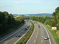
| Federal motorway 6 near Sinsheim | ||||||||||||||||||||||||||||||||||||||||||||||||||||||||||||||||||||||||||||||||||||||||||||||||||||||||||||||||||||||||||||||||||||||||||||||||||||||||||||||||||||||||||||||||||||||||||||||||||||||||||||||||||||||||||||||||||||||||||||||||||||||||||||||||||||||||||||||||||||||||||||||||||||||||||||||||||||||||||||||||||||||||||||||||||||||||||||||||||||||||||||||||||||||||||||||||||||||||||||||||||||||||||||||||||||||||||||||||||||||||||||||||||||||||||||||||||||||||||||||||||||||||||||||||||||||||||||||||||||||||||||||||||||||||||||||||||||||||||||||||||||||||||||||||||||||||||||||||||||||||||||||||||||||||||||||||||||||||||||||||||||||||||||||||||||||||||||||||||||||||||||||||||||||
|
Course of the road
|
||||||||||||||||||||||||||||||||||||||||||||||||||||||||||||||||||||||||||||||||||||||||||||||||||||||||||||||||||||||||||||||||||||||||||||||||||||||||||||||||||||||||||||||||||||||||||||||||||||||||||||||||||||||||||||||||||||||||||||||||||||||||||||||||||||||||||||||||||||||||||||||||||||||||||||||||||||||||||||||||||||||||||||||||||||||||||||||||||||||||||||||||||||||||||||||||||||||||||||||||||||||||||||||||||||||||||||||||||||||||||||||||||||||||||||||||||||||||||||||||||||||||||||||||||||||||||||||||||||||||||||||||||||||||||||||||||||||||||||||||||||||||||||||||||||||||||||||||||||||||||||||||||||||||||||||||||||||||||||||||||||||||||||||||||||||||||||||||||||||||||||||||||||||
The federal autobahn 6 (abbreviation: BAB 6 ) - short form: autobahn 6 (abbreviation: A 6 ) - is a federal autobahn in southern Germany. It leads from the French border near Saarbrücken via Mannheim , Heilbronn and Nuremberg to the Czech border near Waidhaus . As part of European route 50 , which is congruent with it along its entire length, it represents an important long-distance connection between the European capitals Paris and Prague .
course
Saarbrücken to Walldorf
The BAB 6 begins with four lanes at the Goldene Bremm border crossing on the border with France in the area of the Saarland capital Saarbrücken . After crossing the Saar , it joins the Güdingen district at the Saarbrücken triangle on the carriageway of the BAB 620 coming from Saarlouis and ending here . This is followed by a hilly section with several valley bridges until the BAB 8 ( Luxembourg - Pirmasens ) is crossed at the Neunkirchen junction .
After the next junction, Homburg , you leave Saarland and reach Rhineland-Palatinate . Through the flat Landstuhler Bruch , the BAB 6 reaches the Landstuhl-West junction , which connects the BAB 62 ( Nonnweiler - Pirmasens ). The motorway then runs south along the Ramstein military airfield and reaches the city of Kaiserslautern . There are six lanes without hard shoulder between Ramstein-Miesenbach and Kaiserslautern-West. The further section to the triangle Kaiserslautern , where the BAB 63 branches off to Mainz , will be expanded to six lanes with hard shoulder by the end of 2018.
Behind the motorway triangle there is a mountainous four-lane section with numerous curves, inclines, descents and additional lanes, which crosses the Palatinate Forest at its northern end. The low mountain range is left at Wattenheim and the motorway leads in a steep combination of curves at the so-called Laumersheimer Berg into the Rhine plain . There is an extensive panoramic view of the mountain road that runs to the right of the Rhine .
At the Frankenthal junction, the BAB 6 crosses the BAB 61 ( Venlo - Hockenheim ) and marks the beginning of a motorway ring around the cities of Ludwigshafen and Mannheim . On the Theodor Heuss Bridge is the Rhine crossing and the State of Baden-Wuerttemberg reached. Here the road is very straight and leads through a large forest area. Shortly before the BAB 6 merges into the main carriageway of the BAB 67 from Darmstadt, which ends here, at Viernheimer Dreieck and continues south on this six-lane route coming from the north, the state changes again and you are in Hesse . From here the BAB 6 forms the eastern bypass of Mannheim.
At the next junction, the Viernheimer Kreuz , which connects the BAB 659 , the autobahn again reaches Baden-Württemberg. It crosses the Neckar and at the next motorway junction, the Mannheim junction, it crosses the BAB 656 (Mannheim– Heidelberg ). After that, BAB 6 will have four lanes again. After Schwetzingen , the BAB 61 ends at the triangle Hockenheim , which also marks the end of the motorway ring. From here the BAB 6 has six lanes again. Immediately to the east of the road is the famous Hockenheimring race track . While the section from Viernheim to Hockenheim runs almost exactly in a north-south direction, the direction now changes further and further east. Thus the will at the next node, junction Walldorf , the BAB 5 ( Hattenbacher triangle - Basel , the South-North connection is an important, crossed).

At the Goldene Bremm border crossing

Six-lane section west of Kaiserslautern

Descent from the Palatinate Forest to the Rhine plain near Wattenheim

East of Mannheim

.JPG)


Walldorf to Nuremberg
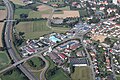
After Walldorf, the motorway leads again in a direct west-east direction. The flat Rhine plain is left and the route reaches the hilly Kraichgau . In Sinsheim, the car and technology museum and the Rhein-Neckar-Arena are in the immediate vicinity of the motorway. After crossing the Neckar again at Neckarsulm , the motorway reaches the Weinsberg junction with the BAB 81 ( Würzburg - Schaffhausen ). In order to stay on the BAB 6, you have to leave the main carriageway here in an easterly direction, as this turns south and then forms the main carriageway of the BAB 81 towards Stuttgart .
Since 2017, the A 6 has been expanded under traffic over a length of 47.2 km from the Wiesloch / Rauenberg junction to the Weinsberg motorway junction in sections from two to three lanes in each direction, including the construction of the Neckar Valley Bridge and numerous other structures. The entire section should be accessible with six lanes by summer 2022.
After leaving the cross, the motorway has four lanes again with a few additional lanes. The hilly area around Heilbronn is left and one reaches the Hohenlohe plain , a plateau in the northeastern part of Baden-Württemberg. The route runs a few kilometers away along the northern edge of the Swabian-Franconian Forest . Due to the numerous river valleys that run through the plain, it also leads over numerous larger bridge structures. The Kochertal Bridge near Schwäbisch Hall is 185 m high and is the highest bridge in Germany. After Crailsheim you leave the plain and climb the first ridge of the Frankenhöhe with a distinctive gradient. At the same time, the federal state changes, you leave Baden-Württemberg and reach Bavaria .
A few kilometers from the border crossing at in Feuchtwangen situated Feuchtwangen / Crailsheim the A7 ( Flensburg - Füssen ). Then there is another uphill stretch to the apex of the ridge. Then the motorway leads into the valley of the Altmühl and bypasses the Central Franconian district capital Ansbach extensively to the south.
At Lichtenau there is another downhill section into the valley of the Franconian Rezat and the landscape slowly becomes flatter and more wooded. Extensive pine forests are typical of the Nuremberg area . Shortly after Schwabach , from here again six lanes, the Main-Danube Canal and then the old Ludwig-Danube-Main Canal , which is no longer used today, are crossed. This is followed by the Nürnberg-Süd junction , which connects the BAB 73 , which is a direct connection both to the city center of Nuremberg and to the BAB 9 to Munich . A few kilometers further on, the BAB 9 will be crossed at the Nürnberg-Ost junction . In the north ( Berlin ) in particular, a lot of traffic leaves the BAB 6. As on most motorway routes in the Nuremberg region, the signposting is equipped with a dynamic traffic control system that is activated at trade fairs and similar major events.
Shortly before Heilbronn

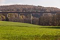
Kochertal Bridge
At Feuchtwangen

Traffic control system near Nuremberg


_-_geo.hlipp.de_-_5922.jpg)

Nuremberg to Waidhaus
After the Nürnberg-Ost junction, the motorway becomes four-lane again and after a few kilometers of straight, flat stretch in the Nuremberg Reichswald, it crosses the BAB 3 ( Emmerich - Passau ) at the Altdorf junction . Immediately afterwards, she climbs out of the Reichswald onto the plateaus of the Franconian Alb and changes to the Upper Palatinate administrative district near Alfeld . As far as Amberg , the motorway is now very curvy and partly hilly, as the low mountain range is crossed here on its main ridge. Shortly before the Sulzbach-Rosenberg junction , the highest point on the entire federal motorway is reached at around 620 m above sea level.
The city of Amberg is bypassed in a very spacious curve to the south, crossing the extensive deer forest . Then the Vilstal is crossed. The Amberg-Ost junction formed the eastern end of the BAB 6 for many years. The gap to the Czech border was only completed in 2008.
After Amberg, the route leads down into the Naab Valley , where the Oberpfälzer Wald junction is located, where the BAB 93 ( Hof - Regensburg - Holledau triangle ) crosses and then the Naab is crossed directly afterwards. This is followed by a slope up into the Upper Palatinate Forest . The section that now follows up to the Czech border is again very winding and hilly. Passing Vohenstrauss you reach the Czech border at Waidhaus . From there, the route continues as the D 5 via Pilsen to Prague .
Unterrieden valley bridge near Altdorf. Here the motorway reaches the Franconian Alb

Cross Upper Palatinate Forest in the Naab Valley
At Vohenstrauss

Waidhaus / Rozvadov border crossing


history
predecessor
Emperor Karl IV. (1316-1378) raised the road connection between the former imperial cities of Nuremberg and Prague to form the imperial road , which is why this section is called Via Carolina . From 1932 and from 1939, Reichsstraße 14 followed the historical model, but also ran west from Nuremberg to around Schwäbisch Hall , where the R 14 (or B 14) swiveled southwest towards Stuttgart.
1933 to 1945 - Reichsautobahn construction
Viernheim – Mannheim

The oldest section of the route, known today as BAB 6, lies between the Viernheim triangle and the Mannheim motorway junction. This was planned as early as the 1920s by the HaFraBa eV association - according to the association's name - as part of a road from Hamburg via Frankfurt to the Swiss border near Basel. Although the detailed plans for this street in the Reichstag around 1930 initially met with broad rejection from the NSDAP (“luxury streets of the rich”), the National Socialists who came to power on January 30, 1933 nevertheless decided to carry out the motorway planning. The main reason for this was the promise to curb the high unemployment at the time by building the highways.
With the groundbreaking on September 23, 1933, construction of the first Reichsautobahn from Frankfurt am Main via Darmstadt and Mannheim to Heidelberg began. The junction that today forms the Mannheim junction was built as a triangle at which the line coming from the north (Frankfurt ) joins the Mannheim – Heidelberg connection (today's BAB 656 ). At Heidelberg, on the other hand, the route later branched off towards the south ( Karlsruhe , Basel ) at a triangle , today the Heidelberg motorway junction is located here . While the autobahns were often praised as a “world first” by Nazi propaganda, only the HaFraBa plans that had been ready for construction since 1932 were implemented for the construction. In order to portray the construction of the autobahn as an alleged invention of Adolf Hitler (“Street of the Führer”), the first autobahn in Germany between Cologne and Bonn, opened a year earlier by the mayor of Cologne, Konrad Adenauer , was downgraded to a state road. The section from Darmstadt via Mannheim to Heidelberg was opened on October 3, 1935. Together with the section from Frankfurt to Darmstadt opened on May 19, 1935, it formed the first section of the motorway to be completed during the National Socialist era .
Kaiserslautern – Viernheim

The motorway from Mannheim via Kaiserslautern to Saarbrücken, known as route 38 , was built from 1934. In the course of this route branching off from the Frankfurt – Mannheim line at Viernheim, several large bridges had to be built. The Rhine bridge near Frankenthal began in 1938, but due to a serious construction accident with 30 deaths on December 12, 1940 and the ongoing Second World War, work on the bridge was no longer completed. The two viaducts, Waschmühle and Lautertal near Kaiserslautern, on the other hand, were built and completed between March 1935 and Christmas 1936. The Kaiserslautern-West-Wattenheim section, including the crossing of the Palatinate Forest, was the only one on the line to go into operation on October 24, 1937. In the course of the advance of the Allies towards the end of the Second World War, the Lautertal Bridge was opened on the night of March 20, 1945 Blown up by Wehrmacht troops .
In an easterly direction, the autobahn was opened in several sections from Wattenheim via Grünstadt to Frankenthal by 1940, this section is characterized by a longer slope from the Palatinate Forest down to the Upper Rhine lowlands . In a westerly direction, the continuation from Kaiserslautern-West to Landstuhl followed until 1941 .
Schwabach – Nuremberg
From 1935 onwards, planning began for a motorway from Heilbronn to Nuremberg (at that time still known as Stuttgart-Nuremberg ), which was assigned to the basic network . In 1938, construction work began on the western end between Weinsberg and Bretzfeld as well as on the eastern end between Schwabach and the connection to the Reichsautobahn Berlin – Munich, later work on the connection was carried out in three lots. Only the section from Nuremberg to Schwabach could be put into operation with a single lane in 1941; construction work on the rest of the line was suspended due to the Second World War.
1945 to 1969 - reconstruction and continuation of construction
Saarbrücken – Viernheim

The section between Frankenthal and Viernheim, which could not be put into operation before the Second World War due to the unfinished Rhine bridge, was rebuilt from 1948. The first half of the bridge to cross the Rhine was opened to traffic on September 9, 1950 by Federal Transport Minister Hans-Christoph Seebohm . In the course of a visit by the then Federal President Theodor Heuss a few days later , the bridge was named Theodor-Heuss-Brücke after him, and it still bears this name today. It was not until 1964 that the second half of the bridge and thus the four-lane expansion of the motorway was completed.
The reconstruction of the Lautertal Bridge, which was blown up during the war, began just a few years after the end of the war. Since part of the new bridge collapsed during the construction work, the re-commissioning of the line was delayed until October 15, 1956. The section east of Kaiserslautern, which was also destroyed by war damage, was already open again in 1951.
As early as the Second World War , the German Air Force used a section of the Reichsautobahn between Landstuhl and Kaiserslautern -West, about three kilometers long - just built for this purpose - as a military airfield . After the Second World War took US troops as an occupying power, this area and erected there the airbase Ramstein (now Ramstein Air Base ). As early as the late 1940s, a hall was built over the old motorway runway and a large, high-performance runway was built about 200 m to the south. The east and west access to the airport, however, still consist of the original route of the former Reichsautobahn Mannheim – Landstuhl; it is shown on most road maps as an "expressway closed to traffic" and is considered a federal private road . In the 1950s, the A 6 was therefore led on a new route in a flat curve to the south of Ramstein Airport and built through the Landstuhler Bruch to the Waldmohr junction , just before the then state border with the then autonomous Saarland .
Since in the course of the Saar referendum it was decided in 1955 to re-annex the Saarland to the Federal Republic of Germany, which was completed on January 1, 1957, the construction of the line to Saarbrücken could also be started on the Saarland side . Two years after reintegration into the Federal Republic of Germany and in the same year as the final, economic accession, the newly routed section from Kaiserslautern to Landstuhl and on via Waldmohr and Homburg to the St. Ingbert -West junction was released on December 14, 1959 . Exactly four years later, on December 14, 1963, the continuation of the motorway to Saarbrücken, which had begun in 1960, was completed and opened to traffic. Since this section has the character of a low mountain range and therefore three large bridges had to be built, at the time of construction it was one of the most expensive motorway sections in Germany at 70 million DM . The section in the Saarbrücken urban area was also extremely complex to build: the stretch from Güdingen to the city center, which was built parallel to the Saar , was designed in a narrow construction due to the cramped space conditions, the front wall of the Saarbrücken castle even had to be demolished and the old bridge extended. Although Saarland was the last western federal state to be connected to the motorway network due to its long-standing special status, Saarbrücken was thus the first major German city with a motorway connection to the city center.
The section from Saarbrücken to the French border ( Goldene Bremm border crossing ) was built from 1968 to 1969 together with the French A320 as a continuation. This branches off from the Saarbrücken – Mannheim route in the Saarbrücken district of Güdingen and leads over two separate, longer bridges over the Saar to the Goldene Bremm border crossing, where a rest area has also been built. Due to the limited space in the Saar Valley, the junction at Güdingen (now the Saarbrücken motorway triangle ) could only be made as a fork . For traffic coming from France to Saarbrücken city center , a connecting ramp was built between the exits and entrances at the Saarbrücken-Fechingen junction just a few hundred meters to the east , which in turn can only be reached from the west due to the topography.
Mannheim – Heilbronn


The section between the Mannheim motorway junction and the Weinsberg motorway junction near Heilbronn is also known as the Neckar Line and was implemented in the 1960s to connect the north of Baden-Württemberg , which was then poorly developed in terms of traffic, to the motorway network. At the same time, the Bergstraßenautobahn from Frankfurt via Darmstadt to Heidelberg was built, which was to serve as a relief route to the old Reichsautobahn Frankfurt – Mannheim and at Heidelberg seamlessly merges with the existing autobahn to Karlsruhe, which was also realized before the Second World War.
The former motorway triangle near Mannheim was converted into a motorway junction, another cross with the old Reichsautobahn line Heidelberg – Karlsruhe was built near Walldorf . The route from Frankfurt, which was originally built in a north-south direction, was thus continuously converted into a route leading in a west-east direction to Heilbronn. Together with the new mountain road motorway, two parallel motorways were created between Darmstadt and Walldorf only a few kilometers apart. During the construction of this route, the Hockenheimring was cut through, which at that time extended to the town of Hockenheim. The section into the village was replaced from 1964 to 1965 by a Motodrom east of the motorway, the grandstands are right next to it.
Between Sinsheim and Bad Rappenau was an approximately 2.7 km long Highway strip furnished to the defense case, prepare a provisional airfield within 24 hours, in particular for the strategic defense of the surrounding cities of Frankfurt, Mannheim, Karlsruhe, Heilbronn and Stuttgart are kept ready for use had to. For this purpose, the motorway was built in a straight line, the median was concreted and equipped with removable crash barriers, and parking spaces were created at both ends of the section, which should serve as parking areas for aircraft. Since the area around the makeshift airfield must be free of air traffic obstacles, no bridges were built. The north-south line from the 1920s , a 220 kV three-phase overhead line that was still of national importance at the time, had to be relocated to the edge of the safety zone and crosses the motorway at the eastern end of the section on very low masts. In the course of the six-lane expansion between Sinsheim and Bad Rappenau (2010–2011), the makeshift airfield was abandoned and the parking spaces to the east were closed. The adjoining motorway parking spaces to the west have been expanded to include a toilet facility.
At Heilbronn, the autobahn was then seamlessly connected to the already existing north-south autobahn from the 1930s to Stuttgart. In the 1970s, the Weinsberg motorway junction, which had been planned in the pre-war period and continued in the direction of Nuremberg , was built in the area of the 90 ° curve . The execution of the Neckar crossing between Heilbronn and Neckarsulm is remarkable . Instead of building a dam in the Neckar Valley and a shorter bridge, the decision was made to build a 1.35 km long bridge structure, on the one hand to keep floodplain areas free and on the other hand to have space for a Neckar Canal planned at the time. In this project, which is no longer taken up, the navigable river bed of the Neckar would have been relocated to the west in order to establish industrial areas north of the port of Heilbronn .
Individual sections were completed before the entire Neckar line between Mannheim and Weinsberg near Heilbronn was opened by Federal Transport Minister Georg Leber with a ceremony near Sinsheim on December 10, 1968 . Of the 390 million DM construction costs, 30 million DM were accounted for by building the Neckar Valley Bridge.
1970 to 1991 - closing the gap and reorganizing
Heilbronn – Nuremberg

Of the 153 km long Heilbronn – Nuremberg connection, the section from today's Nürnberg-Süd motorway junction to the Schwabach- West junction was completed in 1941 and the construction work at the western end near Weinsberg was well advanced, closing the gap between Weinsberg and Schwabach only gradually completed in the 1970s. The first plans for the completion of the line after the Second World War for the section from Schwabach to Ansbach date back to December 1947. Between Weinsberg and Bretzfeld-Schwabbach, investigations were carried out from 1953 for a single-lane continuation of the construction work that had already started, but the Heilbronn – Nuremberg line was carried out not registered for the 2nd four-year plan for the expansion of the federal trunk roads 1963–1966 .
In spite of this, it was recognized in the 1960s that it could be implemented within the next few years under the existing plans. The priority for this connection was not the connection to Czechoslovakia and the Eastern European countries, which were already suspended from the west by the Iron Curtain , but the connection between the economic areas of northern Baden-Württemberg (Mannheim, Heilbronn) and northern Bavaria around Nuremberg.
Therefore, the planning for closing the gap was resumed. The determination of the line according to Section 16 of the Federal Highway Act in 1966 was largely based on the plans from the 1930s, after the regional planning procedure for the Bavarian part was completed in 1965. Only the section in the Kochertal area deviates from the pre-war road: Instead of an elaborate route into the Kochertal valley and a smaller valley bridge, a variant was implemented that has a large bridge 1128 m long and 185 m high.
First, the section from the Weinsberg motorway junction to Bretzfeld was completed using the pre-war road in 1970. Until 1975, construction was carried out on the Baden-Württemberg side up to the Kupferzell junction to the east, on the Bavarian side the motorway was westward in 1973 from Schwabach to Lichtenau and then on to Aurach in 1975 (at that time the Ansbach-West junction ).
The planning approval procedures for the 58 km long gap between Kupferzell and Ansbach were completed on the Bavarian side in 1973 by the North Bavarian Motorway Directorate , and on the Baden-Württemberg side by the Baden-Württemberg motorway office in 1976. From 1976 to 1979 the construction of this line took place and thus the gap on the BAB 6 between Heilbronn and Nuremberg was closed. Numerous large viaducts were built, including the Kochertal Bridge, which is 185 m high, the highest bridge in Germany.
Nuremberg – Amberg
The section from the Altdorf motorway junction to the Amberg- West junction (then Amberg / Kastl ) was built from 1967 and opened in two sections. On November 17, 1970, the 19 km long section from the Altdorf junction to the Alfeld junction, and one year later on November 12, 1971 from Alfeld to Amberg / Kastl, was opened to traffic by the then Deputy Prime Minister Otto Schedl . At the same time, a motorway maintenance depot (today Lauterhofen motorway maintenance depot ) was set up at the Alfeld junction .
From Altdorf-Oberrieden to Poppberg (between the Alfeld and Sulzbach-Rosenberg junctions ), reference was made to a Reichsautobahn route started in the 1930s, route 86 from Nuremberg to Regensburg , the construction of which was no longer started because of the Second World War . Since the Hohenfels military training area was extensively expanded after the war, a different route southwest of the originally planned route had to be chosen for this connection in the 1960s, when today's BAB 3 was built between Nuremberg and Regensburg. The already prepared route therefore became part of the extension of the route coming from Heilbronn . In the course of all these construction measures, the Altdorf cross was also built.
The current motorway connection from Nuremberg via Amberg to Pilsen was not planned by the Supreme Site Management Reichsautobahnen in the 1930s. Instead of Nuremberg, a route from Munich via Regensburg to Karlsbad (Karlovy Vary) was to be built to develop Czechoslovakia - this route was to be implemented at a later date. The section between Wolnzach (connection to the Reichsautobahn Berlin-Munich) and Regensburg was started, but it was not completed until the post-war period - this section is now the northern part of the BAB 93 .
Since the autobahn from Nuremberg to Amberg at that time ended far from the federal border in an area that is still very sparsely populated and, apart from Amberg, there are no major cities on the route, the traffic volume on this section was extremely low for a long time. The continuation to the Amberg-Ost junction was therefore initially only implemented with the southern lane in two-way traffic until 1979.
Also in 1979, after a three-year construction period, the 7 km long gap between the Nuremberg-Ost and Altdorf motorway junctions was closed, making the motorway passable from the French border to Amberg.
Since at the time the border was opened, the motorway still ended in Amberg and thus far away from the German-Czech border, this event had little effect on the A 6. Only the second lane between the Amberg-West and Amberg-East junctions was completed in 1991 so that all completed sections of the A 6 now had two lanes.
Highway numbering
On January 1, 1975, a uniform numbering system was introduced for all federal motorways in Germany. Initially only internal numbering was available for the routes that had already been built and was not shown on the signposts (initially only the numbers of the European roads were shown here ), but from now on the new motorway numbers were used throughout. As an important national east-west connection with connections to the neighboring countries, the Saarbrücken – Mannheim – Heilbronn – Nürnberg – Amberg route was given an even number and became the federal motorway (BAB) 6.
At the western end of the route, the start of the BAB 6 was laid at the Saarbrücken-Goldene Bremm border crossing. Seen from the east, the continuous lane changes the number at the Saarbrücken triangle, it becomes the BAB 620 and continues through the Saarbrücken city center to Saarlouis . To stay on BAB 6, you have to change lanes here. Also at the Viernheimer Dreieck , where the route coming from Saarbrücken joins the north-south route Frankfurt – Mannheim, you have to change lanes from the south in order to stay on the BAB 6. The continuation to the north was given the designation BAB 67 . Through the course of this route to the south, east past Mannheim, and then from Hockenheim / Walldorf to the east, the BAB 6, actually designed as an east-west connection, runs in a north-south direction for about 30 km.
1996 to 2008 - complete completion

Closing the gap from Amberg to the Czech Republic was not tackled until the late 1990s, although the trucks were jammed especially east of the A 93 on federal highway 14 . The first sections from Waidhaus to the federal border and Pleystein to Waidhaus were put into operation in 1997 and 1999, respectively. On July 27, 2005, the approximately ten-kilometer section between the Oberpfälzer Wald motorway junction and a provisional junction east of the Wernberg-Köblitz junction was released. The cost of this section amounted to around 80 million euros. On October 6, 2006, the remaining, previously two-lane section near Pleystein in the direction of the Czech border was inaugurated in a four-lane ceremony after it had been opened to traffic two days earlier.
Construction of the last 20 km long section of the A 6 between Amberg- Ost and the Oberpfälzer Wald junction began in June 2004. An inauguration event took place on September 10, 2008, and traffic was opened the next day. Since then, the A 6 has been continuously passable from France to the Czech Republic.
In the course of closing the gap between Nuremberg and the Czech border, new distance tables were set up, which no longer only point to Amberg, but also to Prague (spelling Prague / Praha ) as the upper long-term destination in the east . Small additional signs on the boards indicate the naming as Via Carolina . Similar signs can be found on the Czech D 5 .
List of traffic clearances
| section | year | km |
|---|---|---|
| Goldene Bremm – Dreieck Saarbrücken border crossing | 1969 | 5.0 km |
| Triangle Saarbrücken – AS St. Ingbert-West | 1963 | 9.4 km |
| AS St. Ingbert-West – Kreuz Landstuhl | 1959 | 37.0 km |
| Landstuhl – AS Kaiserslautern-West junction | 1941 | 13.0 km |
| AS Kaiserslautern-West – AS Wattenheim | 1937 | 30.0 km |
| AS Wattenheim – Tiefenthal | 1938 | 4.0 km |
| Tiefenthal – AS Grünstadt | 1939 | 6.0 km |
| AS Grünstadt – AS Frankenthal | 1940 | 12.3 km |
| AS Frankenthal – AS Mannheim-Sandhofen | 1950, 1961 | 7.0 km |
| AS Mannheim-Sandhofen-Viernheimer Dreieck | 1953, 1961 | 8.3 km |
| Viernheimer Dreieck-Kreuz Mannheim | 1935 | 10.0 km |
| Cross Mannheim – AS Mannheim / Schwetzingen | 1968 | 6.0 km |
| AS Mannheim / Schwetzingen – AS Schwetzingen / Hockenheim | 1967 | 6.0 km |
| AS Schwetzingen / Hockenheim – Kreuz Walldorf | 1966 | 10.0 km |
| Cross Walldorf – AS Sinsheim | 1967 | 18.0 km |
| AS Sinsheim – AS Heilbronn / Neckarsulm | 1968 | 30.0 km |
| AS Heilbronn / Neckarsulm – Kreuz Weinsberg | 1965 | 7.5 km |
| Cross Weinsberg – AS Bretzfeld | 1970 | 9.0 km |
| AS Bretzfeld – AS Kupferzell | 1975 | 23.0 km |
| AS Kupferzell – AS Ansbach-West | 1979 | 58.6 km |
| AS Ansbach-West – AS Lichtenau | 1975 | 22.4 km |
| AS Lichtenau – AS Schwabach-Süd | 1973 | 26.1 km |
| AS Schwabach-Süd – Kreuz Nürnberg-Süd | 1941 | 9.1 km |
| Kreuz Nürnberg-Süd – Kreuz Nürnberg-Ost | 1938 | 5.0 km |
| Nürnberg-Ost-Kreuz Altdorf intersection | 1979 | 6.8 km |
| Cross Altdorf – AS Alfeld | 1970 | 19.0 km |
| AS Alfeld – AS Amberg-West | 1971 | 18.2 km |
| AS Amberg-West – AS Amberg-Ost | 1979, 1991 | 16.6 km |
| AS Amberg-Ost – Kreuz Oberpfälzer Wald | 2008 | 20.4 km |
| Cross Oberpfälzer Wald – AS Vohenstrauß-Ost | 2005 | 10.0 km |
| AS Vohenstrauß-Ost – AS Pleystein | 2004 | 5.1 km |
| AS Pleystein – AS Waidhaus | 1999 | 2.5 km |
| AS Waidhaus - border crossing Waidhaus / Rozvadov (CZ) | 1997 | 4.2 km |
Current state of development
Even today, the state of development largely corresponds to the age of the motorway. In contrast to the A 2 , A 4 and A 8 , which have been fundamentally and continuously modernized as important internal German connections since the 1990s, only sections of the A 6 have so far been expanded, despite the increased traffic volume due to EU accession and the Schengen Agreement in particular from Eastern Europe makes this urgently necessary.
The kilometering of the A 6 has a special feature. In the 1930s, the number of kilometers traveled was counted from today's Potsdam motorway triangle (on the Berliner Ring ), starting via Erfurt and Frankfurt am Main to the Viernheimer Dreieck and continued from there in both branches towards Kaiserslautern and Mannheim. This results in a change in direction of the kilometers at kilometer 555.7 at the Viernheimer Dreieck when driving continuously on the A 6.
France to Landstuhl
The Saarland section of the A 6 has been expanded to four lanes up to and including the Landstuhl-West junction. Only east of Saarbrücken were the emergency lanes in the inclined areas converted into third lanes.
On March 24, 2016, the Fechinger Viaduct was closed for an indefinite period due to static deficiencies . On May 16, 2016, the bridge was released for vehicles up to 3.5 t total weight. Heavier vehicles that disregarded the entry ban were recognized by an automatic weighing system and stopped by a barrier. Such vehicles were then escorted off the motorway by the police in front of the bridge.
After the bridge piers were reinforced by introducing additional cross struts, the bridge has been approved for vehicles over 3.5 tonnes since October 31, 2016. The costs for the immediate measures such as the weighing system and the reinforcement work are estimated to total over ten million euros. Nevertheless, a new building is necessary.
Landstuhl to Frankenthal
Here, too, the motorway was originally built with four lanes, but there are several sections in which one or both lanes have an additional third lane. Between 2015 and 2017, the hard shoulder between the Landstuhl-West junction and the Ramstein-Miesenbach junction was redesigned in both directions as a continuous acceleration or deceleration lane.
Since June 2006, six lanes of the A 6 have been accessible to the Kaiserslautern- West junction . For this purpose, the hard shoulder was omitted and emergency bays on the roadway were added instead. In addition, a traffic control system was built between the junction in Kaiserslautern-Einsiedlerhof and Wattenheim . The six-lane extension to the Kaiserslautern motorway triangle was completed in mid-2018. It turned out to be very complex due to the construction of two bridge structures - the old Waschmühl and Lautertal bridges, which in the 1930s were designed for four lanes without hard shoulder, were supplemented by a northern parallel bridge structure. The former military connection point in Kaiserslautern was expanded to become the Kaiserslautern-Ost connection point (16b).
Frankenthal to Hockenheim

The motorway has four lanes up to the Viernheimer Dreieck , where the A 6 changes to the lane of the A 67 coming from Darmstadt . The Theodor Heuss Bridge over the Rhine is also located in this area.
The four-lane area between the Viernheimer Dreieck and the Mannheim junction was expanded to six lanes plus hard shoulder between 2000 and Easter 2009. The width of the lane on the 6.5 km long section changed from 8 m to 14.50 m in each direction of travel. At the Viernheim intersection , the right-hand lane merges into the deceleration lane in the direction of A 659 , and immediately after the junction, a new lane begins on the left-hand side. In return, it is easier to unthread towards the A 659. At Mannheimer Kreuz , too , the right-hand lane becomes the deceleration lane in the direction of the A 656, but after the junction the A 6 continues in two lanes so that no new lane begins.
As part of the construction project, the total cost of which was 93 million euros, seven bridge and underpass structures were built, including the new construction of the 400-meter-long Neckar Bridge. In addition, the new Linsenbühl rest area with 22 parking spaces for trucks and 39 parking spaces for cars as well as a toilet facility was created and two rainwater clarification basins were built. Responsibility for design, construction management and supervision lay with the Karlsruhe Regional Council . Particular emphasis was placed on noise protection. This was achieved through the following measures:
- Noise-reducing, non-slip road surface made of a new type of exposed aggregate concrete
- Re-routing of the motorway (lane is lowered by up to 10 m for noise protection reasons.)
- Construction of approx. 10.5 km of noise barriers and noise barriers (approx. 60,000 m²)
These measures should achieve a noise reduction of up to ten decibels . This corresponds to a 90% reduction in traffic volume.
Although the A 6 basically represents a west-east connection, the section from the Viernheimer Dreieck via the Hockenheim triangle to the Walldorf junction runs for about 30 km largely parallel to the A 5 in a north-south direction.
Hockenheim to Weinsberg
From the Hockenheim triangle, the A 6 again has six lanes. The heavily trafficked section from the Walldorf junction to the Weinsberg junction, which originally had four lanes, was and will be expanded in stages to six lanes with hard shoulder. In the direction of Heilbronn, between the Walldorf junction and the Wiesloch / Rauenberg junction, as well as between the Sinsheim-Steinfurt and Heilbronn / Untereisesheim junction, another lane was designated without the hard shoulder in order to enable the slow truck columns to overtake in mountainous terrain. This happened in both directions between Heilbronn / Untereisesheim and Kreuz Weinsberg. Since the hard shoulder was removed and the width of the carriageway was originally dimensioned for two lanes in each direction, the lanes were narrowed.
The expansion between the Walldorf junction and the Wiesloch / Rauenberg junction (32) was completed in the early 2000s. This was followed by the section between the Sinsheim (33a) and Sinsheim-Steinsfurt (34) junctions. In order to connect the Sinsheim Auto and Technology Museum and the Rhein-Neckar-Arena to the autobahn, the Sinsheim- Süd junction (33b) was built in 2008 .
The 8.7 km long section from Sinsheim-Steinsfurt to the Bad Rappenau junction (35) was expanded to six strips from March 2010 and released on November 15, 2011. The expansion, which cost around 65 million euros, was completed within just 20 months, six weeks earlier than planned. The former Kirchardt motorway makeshift airfield was located in this area. With the expansion, this was abandoned and the parking spaces at the western end of the section, which were formerly used to park and turn around the aircraft, were converted into an unmanaged rest area with a toilet.
The remaining sections on this section - Wiesloch / Rauenberg to Sinsheim and Bad Rappenau to Kreuz Weinsberg - are currently (April 2019) under construction.
Weinsberg to Nuremberg
The initially four-lane route east of the Weinsberg motorway junction widens to six lanes after the first junction at Bretzfeld (39). The A 6 then has six lanes as far as the Kupferzell junction (42), and from there four lanes again to shortly before Nuremberg. However, additional lanes are set up, especially on uphill sections.
The Nürnberg-Süd motorway junction has been expanded to include a connection ramp ( overfly ). This two-lane ramp for cross-corner traffic from the A 6 from Heilbronn to the A 73 in the direction of Nuremberg eliminated one of the main causes of traffic problems that occur almost daily in the south of Nuremberg and was opened to traffic on December 22, 2005.
The heavily trafficked section between the Roth (57) junction and the Nürnberg-Süd motorway junction was also expanded to six lanes from 2009, with a new bridge structure being built over the Main-Danube Canal . On September 19, 2011, the section was opened to traffic.
On July 30, 2014, federal funds for the section between the Nuremberg-South and Nuremberg-East motorway junctions were released. Preparatory expansion measures began in spring 2014, the actual expansion not until 2015. The work was completed on August 9, 2017. Since 16./17. August 2017 all six lanes are passable.
Building law has existed between AS Schwabach-West and AK Roth since December 30, 2011. Preparatory work began here in spring 2016, and the actual expansion will begin in 2017.
Nuremberg to the Czech Republic
The route has four lanes from the Nürnberg-Ost motorway junction .
Connections to other countries
From the Landstuhl-West junction , the A 6 is signposted in a westerly direction with the long-term destination Paris . From the French border, the road continues as the A320 autoroute to Freyming-Merlebach , where it in turn joins the A4 autoroute (Paris – Strasbourg ).
In the opposite direction, from the Roth junction, the long-term destination is Prague , where the road as Dálnice 5 leads from the Czech border . Together, the A 6 and its connecting lines form the Europastraße 50 .
Construction progress / planning status
Federal Transport Infrastructure Plan 2003
The urgent need of the Federal Transport Infrastructure Plan 2003 is the six-lane expansion of the sections between Kaiserslautern-West and the Kaiserslautern triangle, between the Walldorf intersection and Schwäbisch Hall and between the Nürnberg-Süd intersection and the Nürnberg-Ost intersection. The sections from AS Kaiserslautern-West to Dreieck Kaiserslautern, sections between AK Walldorf and Schwäbisch Hall and the section from Kreuz Nürnberg-Süd to Kreuz Nürnberg-Ost are under construction.
The expansion of further sections was also planned as required by the Federal Transport Infrastructure Plan of 2003:
- Six-lane expansion from the Saarland / Rhineland-Palatinate border to the Ramstein-Miesenbach junction
- Six-lane expansion from the Kaiserslautern triangle to the Viernheimer Dreieck
- Six-lane expansion from Kreuz Mannheim to Dreieck Hockenheim
- eight-lane expansion of the Hockenheim triangle section to Walldorf intersection
- six-lane expansion between Schwäbisch Hall and Schwabach-West (with planning rights)
- Six-lane expansion from the Nürnberg-Ost intersection to Altdorf intersection.
The 65-km long section between the motorway junction vineyard and the Bavarian border is not only to six lanes from built but with six strips along the existing route for 750 million euros completely newly built are. Six of the seven existing bridges are also to be rebuilt, only the Kochertal Bridge will remain. The plan approval should be completed in all sections by 2019 . Construction work is not expected to begin before the end of the decade; a possible completion date would then be 2025.
Federal Transport Infrastructure Plan 2030
The Federal Transport Infrastructure Plan 2030 contains the six-lane expansion between the Schwabach-West and Roth junctions as well as the motorway junctions Nuremberg-South and Nuremberg-East as ongoing and firmly planned projects .
| Route section | Costs according to BVWP 2030 | current project costs | Increase in costs |
|---|---|---|---|
| AS Schwabach-West to AS Roth | € 110.9 million | € 140 million | + 26% |
While the expansion plans east of Mannheim were taken over from the Federal Transport Infrastructure Plan 2003, the six-lane expansion west of Landstuhl and between the Kaiserslautern triangle and the Viernheimer Dreieck are no longer included in the Federal Transport Infrastructure Plan 2030.
Current projects
east of AS Wiesloch / Rauenberg to AS Sinsheim: Originally, this section was four-lane with a hard shoulder on both sides. In the direction of Heilbronn, however, the hard shoulder was re-marked as the third lane. The planning approval decision for the six-lane expansion was issued on April 9, 2013, the expansion started on January 1, 2017. On November 15, 2018, a 5.9-kilometer-long, expanded section in the direction of Mannheim was released. The Heilbronn direction will be expanded from October 2019 until the end of 2020.
AS Bad Rappenau to AS Heilbronn / Untereisesheim: The direction of travel Heilbronn was marked as three lanes without a hard shoulder. In the direction of Walldorf, the development status was 2 lanes with hard shoulders. For this section, the planning approval decision for the six-lane expansion was issued on July 27, 2012. The expansion began on January 1, 2017.
AS Heilbronn / Untereisesheim to AK Weinsberg: The section was marked with six lanes and no hard shoulder. Since the Neckar Valley Bridge in Heilbronn could not withstand the loads, it was marked back on 4 strips. In both directions, the right of the three lanes leading to the bridge was marked as an extended turning lane to the Heilbronn / Untereisesheim and Heilbronn / Neckarsulm exits.
The expansion of the section and the new construction of the Neckar Valley Bridge began together with the expansion of the section AS Bad Rappenau - AS Heilbronn / Untereisesheim. Since April 2, 2019, traffic has been running over the first new half of the bridge. This also began the demolition of the old bridge structure. This should be completed by September 2019. During the Federal Garden Show in Heilbronn , 6 lanes will be temporarily available to traffic on the new bridge. The entire project is expected to be completed in 2022.
AK Nürnberg-Ost: The intersection Nürnberg-Ost is to be adapted to the current traffic flows. The busy, indirect ramp Heilbronn – Berlin is to be replaced by a two-lane, semi-direct ramp ( overfly ). In addition, the direct ramp on the Berlin – Heilbronn route is to be expanded to two lanes. The renovation started in 2019 and should be completed by the end of 2024.
Trivia
As of January 1, 2016, the responsibilities for the A 6 were as follows:
- Free State of Bavaria
- in the Schnelldorf junction (47) and Schwabach-West junction (55) at the Herrieden motorway maintenance facility,
- in the area of junction Schwabach-West (55) and motorway junction Altdorf with the A 3 (61/89) at the Fischbach motorway maintenance facility,
- in the area of the Altdorf interchange with the A 3 (61/89) and the Oberpfälzer Wald interchange with the A 93 (28/70) at the Lauterhofen / Schwandorf autobahn maintenance office,
- in the area of the Oberpfälzer Wald motorway junction with the A 93 (28/70) and the Waidhaus junction (76) at the Weiden / Vohenstrauß road maintenance depot.
See also
literature
- Klaus Schefold, Alois Neher (Ed.): 50 years of motorways in Baden-Württemberg. A documentation. On behalf of the Autobahn Office Baden-Württemberg. Baden-Württemberg motorway office, Stuttgart 1986.
Web links
- Detailed route description of the federal motorway 6
- History of the A 6
- “A6 - The Axis of Evil: A Motorway as a Problem Road”, a film by Hajo Baumgärtner and Karin Haug
Individual evidence
- ↑ ViA6West website , accessed June 10, 2018.
- ↑ ViA6west: BAB A6 AS Wiesloch / Rauenberg - AK Weinsberg. The project. Retrieved August 23, 2020 .
- ↑ a b Marion Hombach and Joachim Telgenbüscher: Das Märchen von der Autobahn, p. 85. (No longer available online.) In: GEO EPOCHE No. 57 - 10/12 - Germany under the swastika - Part 1 . September 27, 2012, archived from the original on November 9, 2012 ; accessed on July 26, 2018 .
- ↑ A 6 The Waschmühltalbrücke eAutobahn.de, accessed on July 26, 2018
- ↑ 38th meeting in Saarbrücken - valley crossings in Saarland Arbeitsgemeinschaft Autobahngeschichte (AGAB) eV, accessed on July 26, 2018
- ↑ a b First motorways in Saarland Saarländischer Rundfunk, accessed on July 26, 2018
- ↑ Radio Regenbogen: The A 6 celebrates its 50th birthday. December 18, 2018, accessed January 8, 2019 .
- ↑ Voice: When Sinsheim became a suburb of Heilbronn. December 10, 2018, accessed January 8, 2019 .
- ↑ a b History of the A6 autobahn-online.de, accessed on July 26, 2018
- ↑ A6 - six-lane expansion between the Weinsberg motorway junction and the state border between Baden-Württemberg and Bavaria, Stuttgart Regional Council, accessed on July 26, 2018
- ↑ For four decades daily on the axis Onetz.de from August 14, 2010, accessed on July 14, 2018
- ^ Section Nuremberg - Regensburg (route 86) webreichsautobahn.de, accessed on July 15, 2018
- ^ History of the OBR Nürnberg autobahn-online.de, accessed on July 26, 2018
- ↑ List of traffic clearances
- ↑ Compilation of the traffic clearances 1969. In: autobahn-online.de. Retrieved November 13, 2018 .
- ^ Section Saarbrücken-Zentrum – AS St. Ingbert-West, today partially BAB 620
- ↑ Compilation of the traffic clearances 1963. In: autobahn-online.de. Retrieved November 13, 2018 .
- ↑ Compilation of the traffic clearances 1959. In: autobahn-online.de. Retrieved November 13, 2018 .
- ↑ a b Autobahn opening in 1941. In: autobahn-online.de. Retrieved November 13, 2018 .
- ↑ Motorway openings in 1937. In: autobahn-online.de. Retrieved November 13, 2018 .
- ↑ a b Autobahn opening in 1938. In: autobahn-online.de. Retrieved November 13, 2018 .
- ↑ Motorway openings in 1939. In: autobahn-online.de. Retrieved November 13, 2018 .
- ↑ Motorway openings in 1940. In: autobahn-online.de. Retrieved November 13, 2018 .
- ↑ 1st direction lane 1950, 2nd direction lane 1961
- ↑ Compilation of the traffic clearances 1950. In: autobahn-online.de. Retrieved November 13, 2018 .
- ↑ a b Compilation of the traffic clearances 1961. In: autobahn-online.de. Retrieved November 13, 2018 .
- ↑ 1st direction lane 1953, 2nd direction lane 1961
- ↑ Compilation of the traffic clearances 1953. In: autobahn-online.de. Retrieved November 13, 2018 .
- ^ Approval as part of the Darmstadt – Mannheim line
- ^ Motorway openings in 1935. In: autobahn-online.de. Retrieved November 13, 2018 .
- ↑ a b Compilation of the 1968 traffic releases. In: autobahn-online.de. Retrieved November 13, 2018 .
- ↑ a b compilation of the traffic clearances 1967. In: autobahn-online.de. Retrieved November 13, 2018 .
- ^ Opening of the Motodrom at the Hockenheimring in May 1966
- ↑ Compilation of the traffic clearances 1965. In: autobahn-online.de. Retrieved November 13, 2018 .
- ↑ a b compilation of the traffic clearances 1970. In: autobahn-online.de. Retrieved November 13, 2018 .
- ↑ a b compilation of the traffic clearances 1975. In: autobahn-online.de. Retrieved November 13, 2018 .
- ↑ a b c compilation of traffic releases 1979. In: autobahn-online.de. Retrieved November 13, 2018 .
- ↑ Today AS Herrieden
- ↑ Compilation of the traffic releases 1973. In: autobahn-online.de. Retrieved November 13, 2018 .
- ↑ Compilation of the traffic clearances 1971. In: autobahn-online.de. Retrieved November 13, 2018 .
- ↑ 1st directional lane 1979, 2nd directional lane 1991
- ↑ Compilation of the traffic clearances 1991. In: autobahn-online.de. Retrieved November 13, 2018 .
- ↑ Compilation of the traffic releases 2008. In: autobahn-online.de. Retrieved November 13, 2018 .
- ↑ Compilation of the traffic clearances 2005 . In: autobahn-online.de. Retrieved November 13, 2018 .
- ↑ Compilation of the traffic releases 2004. In: autobahn-online.de. Retrieved November 13, 2018 .
- ↑ Compilation of the traffic clearances 1999. In: autobahn-online.de. Retrieved November 13, 2018 .
- ↑ Compilation of the 1997 traffic releases. In: autobahn-online.de. Retrieved November 13, 2018 .
- ↑ Numbering of the motorways. Working Group on Autobahn History, archived from the original on February 22, 2014 ; accessed on March 25, 2016 .
- ↑ Presentation on autobahn-online.de
- ↑ sr.de ( Memento from March 29, 2016 in the Internet Archive )
- ↑ saarland.de
- ^ Saarländischer Rundfunk: Delay in the allocation of rail transport . In: SR.de . January 5, 2017 ( sr.de [accessed January 5, 2017]). Delay in the allocation of rail transport ( Memento from May 16, 2016 in the Internet Archive )
- ^ Saarländischer Rundfunk: Viaduct will be open again at the end of October . In: SR.de . January 9, 2016 ( sr.de [accessed January 5, 2017]). Viaduct reopened at the end of October ( memento from September 2, 2016 in the Internet Archive )
- ^ A 6 Kaiserslautern ( Memento from November 10, 2011 in the Internet Archive ) Construction projects of the Rhineland-Palatinate Mobility Office
- ↑ Reports on the A 6 , eautobahn.de
- ↑ Motorway Directorate North Bavaria: Information sheet A6 six-lane expansion. (No longer available online.) In: www.abdnb.bayern.de. Archived from the original on October 5, 2016 ; Retrieved October 5, 2016 .
- ↑ Plan approval decision with integrated environmental impact assessment for the 6-lane expansion of the A6 Heilbronn-Nürnberg (PDF; 571 kB)
- ↑ Finally: The bottleneck on the A6 near Nuremberg has been expanded. In: www.nordbayern.de. Retrieved September 14, 2017 .
- ↑ Autobahn Directorate North Bavaria: Info sheet A6 six-lane expansion between Schwabach and Roth. In: www.abdnb.bayern.de. Retrieved October 5, 2016 .
- ↑ Federal motorway A 6, six-lane expansion from Weinsberg to the state border, expansion in the Bretzfeld-Kupferzell area (sections A 6-2 and A 6-3), public information event before the plan approval is initiated on June 21, 2017 in Öhringen (PDF) Ministry of Transport Baden-Württemberg . Retrieved October 28, 2017.
- ↑ Ralf Reichert: Autobahn 6 will be completely rebuilt . In: Heilbronn voice . February 19, 2011 ( from Stimme.de [accessed on March 11, 2011]).
- ↑ Ralf Reichert: The will is there, the questions remain . In: Heilbronn voice . March 10, 2011 ( from Stimme.de [accessed on March 11, 2011]).
- ↑ Autobahn Directorate North Bavaria: Six-lane expansion between the Schwabach-West and Roth junctions . September 2016, online at www.abdnb.bayern.de, accessed on October 2, 2016.
- ↑ Federal Law Gazette I pp. 3354, 3356 , lists of projects sorted by federal states.
- ^ A 6 between Rauenberg and Sinsheim: regional council approves eleven kilometers of six-lane expansion. Karlsruhe Regional Council , April 9, 2013, accessed April 10, 2013 .
- ↑ More space on three new lanes. In: via6west.de. Retrieved January 15, 2019 .
- ↑ Landtag of Baden-Württemberg (ed.): Expansion of the A 6 (printed matter 15/2238) . Application from Abg. Nicole Razavi and others CDU and statement from the Ministry of Transport and Infrastructure. August 15, 2012 ( landtag-bw.de [accessed on November 28, 2015]).
- ↑ Contract for A6 expansion granted - STIMME.de. In: www.stimme.de. Retrieved December 26, 2016 .
- ^ Daniel Stahl: Traffic in front of the Neckarsulm exit should soon flow better . In: Heilbronn voice . February 26, 2014 ( traffic in front of the Neckarsulm exit should soon flow better [accessed on January 6, 2015]).
- ↑ Now the traffic is rolling over the bridge. In: via6west.de. Retrieved April 3, 2019 .
- ↑ Bridge wedding at the Neckar valley crossing. In: via6west.de. Retrieved January 15, 2019 .
- ↑ Expansion of the A 6: With six lanes against the traffic blackout . ( rnz.de [accessed December 26, 2016]).
- ↑ Reconstruction of the Nürnberg-Ost motorway junction. In: abdnb.bayern.de. Retrieved May 7, 2020 .
- ↑ Supreme building authority in the Bavarian State Ministry of the Interior, for construction and traffic: Free State of Bavaria - Road overview map - Responsibilities of the motorway maintenance authorities . PDF. January 1, 2016, online at www.baysis.bayern.de, accessed on September 17, 2016.
