
District of Loerrach
| coat of arms | Germany map |
|---|---|

|

Coordinates: 47 ° 37 ' N , 7 ° 40' E |
| Basic data | |
| Existing period: | 1973– |
| State : | Baden-Württemberg |
| Administrative region : | Freiburg |
| Region : | Upper Rhine-Lake Constance |
| Administrative headquarters : | Loerrach |
| Area : | 806.76 km 2 |
| Residents: | 228,639 (Dec. 31, 2018) |
| Population density : | 283 inhabitants per km 2 |
| License plate : | LÖ |
| Circle key : | 08 3 36 |
| NUTS : | DE139 |
| Circle structure: | 35 municipalities |
| Address of the district administration: |
Palmstrasse 3 79539 Loerrach |
| Website : | |
| District Administrator : | Marion Dammann ( Free Voters ) |
| Location of the district of Loerrach in Baden-Württemberg | |
  |
|
The district of Lörrach is a district in the extreme southwest of the state of Baden-Württemberg ( Germany ). It belongs to the administrative district of Freiburg and the regional association Hochrhein-Bodensee .
geography
location
The Wiesental (named after the Wiese river ) as the northeastern part of the district belongs to the Black Forest and stretches up to the Feldberg , the highest mountain in the Black Forest . In the west rise the vineyards of the Markgräfler hill country , in the south the Dinkelberg . Between Dinkelberg and the Swiss Jura , the High Rhine Valley stretches westwards and widens northwards to Basel to the Upper Rhine Plain .
Division of space

According to data from the State Statistical Office , as of 2015.
nature
The district of Loerrach has the following nature reserves . According to the protected area statistics of the State Institute for the Environment, Measurements and Nature Conservation Baden-Württemberg (LUBW), 6,162.82 hectares of the district are under nature protection, that is 7.64 percent.
- Old Rhine Wyhlen : 23.4 hectares; Community Grenzach-Wyhlen - district Wyhlen
- On the corner : 3.1 ha; Community Schliengen - districts Liel and Mauchen
- Belchen : 1614.8 ha (of which 1239.6 ha in the Lörrach district); Municipality Small Wiesental - Neuenweg district, community Böllen - district Böllen, community Schönberg - Schönberg district, municipality Aitern - Aitern district and community Wieden - Wieden district
- Blansinger Grien : 23.6 ha; Commune Efringen-Kirchen - districts Kleinkems and Huttingen
- Buchswald near Grenzach : 92.8 ha; Grenzach-Wyhlen community - Grenzach and Wyhlen districts
- Buhrenboden : 16.1 ha; City of Rheinfelden - districts Eichsel and Minseln
- Buttenberghalde : 18.8 ha; Community Inzlingen - Inzlingen district
- Eichholz-Buchholz : 34.6 ha; Bad Bellingen municipality - Rheinweiler district , Efringen-Kirchen municipality - Kleinkems district
- Feldberg : 4226 ha (of which 738.9 ha in the Lörrach district); City of St. Blasien - Menzenschwand district , Bernau municipality in the Black Forest - Bernau district
- Gallows Hole : 11.8 ha; Municipalities of Bad Bellingen - Bellingen district, Schliengen municipality - Schliengen marking
- Präg glacier basin : 2,866.8 ha; City of Todtnau - districts Todtnau, Geschwend , Präg and Schlechtnau , city of Schönau in the Black Forest - district of Schönau and municipality of Tunau - district of Tunau
- Isteiner Klotz : 26.0 ha; Efringen-Kirchen community - Huttingen , Istein and Kleinkems districts
- Kapellengrien : 65.9 ha; Bad Bellingen municipality - Rheinweiler district, Efringen-Kirchen municipality - Kleinkems district
- Käppelin gravel pit : 21.7 ha; City of Weil am Rhein - District Weil am Rhein
- Weberalten gravel pit : 6.3 ha; City of Rheinfelden - Herten district
- Krebsbachtal : 22.8 ha, city of Weil am Rhein - districts of Weil and Haltingen
- Langenbach-Trubelsbach : 36.0 ha; City of Todtnau - Muggenbrunn district
- Leuengraben : 139.9 ha; City of Rheinfelden - Herten district, Grenzach-Wyhlen community - Wyhlen district
- Nonnenmattweiher : 70.8 ha; Municipality Small Wiesental - district Neuenweg
- Rümminger Moos : 12.2 ha; Community Rümmingen - district Rümmingen
- Ruschbachtal : 30.7 ha; Grenzach-Wyhlen community - Wyhlen district
- Rütscheten : 5.6 ha; Bad Bellingen municipality - Bad Bellingen district
- Graveyard : 2.8 ha; Efringen-Kirchen community - Istein district
- Utzenfluh : 272.5 ha; Community Utzenfeld - district Utzenfeld, City Todtnau - districts Schlechtnau and Geschwend
- Mouth of the weir : 12.1 ha; City of Wehr - district Öflingen , municipality Schwörstadt - district Schwörstadt
- Wiedener Weidberge : 379.0 ha; Wieden municipality - Wieden district
Neighboring areas
The district borders on the Breisgau-Hochschwarzwald district in the north and the Waldshut district in the east . It also borders clockwise with Switzerland (cantons Aargau , Basel-Landschaft and Basel-Stadt ) and France ( Département Haut-Rhin in the former Alsace region ).
history
Administrative districts at the end of the Old Kingdom
At the end of the "Old Empire" around 1800 there were a large number of administrative districts in what is now the Lörrach district. This was not unusual for the south-west of Germany, but the fragmentation did not only exist at the level of the manors and imperial estates , but areas of the district were also in three different imperial districts .
There was also fragmentation within the Upper Austrian Office of Breisgau . Only the Rheinfelden cameraman was directly subordinate to the government in Freiburg. In addition, three members of the Breisgau prelate class (St. Blasien monastery, Säckingen dynasty, Deutschordenskommende Beuggen) and four members of the Breisgau knighthood (barons of Andlau, von Baden, von Rotberg, von Schönau) ruled in the area of today's Lörrach district.
Historic administrative districts of Baden in the area of today's Lörrach district
From 1803 to 1939 there were a number of more or less long-lived administrative districts in the Electorate of Baden , the Grand Duchy of Baden and the Republic of Baden in the area of today's Lörrach district.
| District Office | from ... to | rose in | Remarks |
|---|---|---|---|
| Oberamt Rötteln | until 1810 | District offices Lörrach, Schopfheim, Kandern | |
| District Office Lörrach | 1810 | emerged from the dissolution of the Oberamt Rötteln | |
| District Office Schopfheim | 1810 to 1938 | District Office Lörrach | emerged from the dissolution of the Oberamt Rötteln |
| District Office Kandern | 1810 to 1819 | District offices of Schopfheim, Lörrach, Müllheim | emerged from the dissolution of the Oberamt Rötteln |
| District Office Schönau | 1807 to 1924 | District Office Schopfheim | |
| District Office Schliengen | 1803 to 1809 | District offices Kandern, Lörrach | de facto since 1802 |
| District Office Beuggen | 1807 to 1809 | District offices Lörrach, Schopfheim, Säckingen | Predecessor since 1806: "Breisgauisches KammeralAmt des Rheinthals in Nollingen" |
| District Office Säckingen | 1807 to 1973 | Districts of Waldshut and Lörrach | from 1939 own district |
From the transition of the Landvogtei Schliengen to Baden (de facto 1802) to 1809 there was still a Baden Oberamt Schliengen, which was then dissolved as part of the administrative reform of the Grand Duchy and largely assigned to the Kandern district office . Istein and Huttingen came to the district office of Lörrach in 1809.
In 1803, the Upper Austrian Upper Office Breisgau came to the short-lived Duchy of Modena- Breisgau through the Reichsdeputationshauptschluss , which was soon inherited back to the House of Habsburg. Through the Peace of Pressburg , this duchy came to the Electorate of Baden in 1806 , which Napoleon made the Grand Duchy of Baden in the same year .
The south-western parts of the Oberamt Breisgau (dominion Zell and Talvogteien Schönau and Todtnau) were assigned to the Grand Duke of Baden “ObervogteyAmt Schönau” (later District Office Schönau ) by the general tender on the division of the Grand Duchy of Baden into districts of July 7, 1807 . The previous manorial offices of Bellingen, Liel, Bamlach, Rheinweiler and Stetten were assigned to the Oberamt Rötteln.
The previous area of the German Order Coming Beuggen and the Rhine Valley landscape were combined in the new Baden office of Beuggen. In 1809 the office of Beuggen was dissolved and its municipalities were divided between the offices of Lörrach, Schopfheim and Säckingen.
The manorial rule of the barons of Schönau-Schwörstadt was initially assigned to the new Baden Oberamt Säckingen . These communities only came to the district of Lörrach in 1973.
With the organizational rescript of November 26, 1809, the previous Oberamt Rötteln was dissolved and its place was replaced by the new district offices of Lörrach, Schopfheim and Kandern , which together with other offices formed the Wiesenkreis , which then merged into the Dreisamkreis in 1815.
Development of the middle administrative level in Baden
On May 1, 1832, the remaining six districts were dissolved and replaced by four newly founded districts. The authority was no longer called the district directorate , but the district government , each headed by a government director and supported by government councilors and government assessors. The area of the Dreisamkreis became part of the new Upper Rhine District to which the offices of Lörrach, Schopfheim and Schönau also belonged.
The large districts that existed in Baden between 1809 and 1863 are not to be seen as the predecessors of today's districts, but rather corresponded to today's regional councils.
The law on the organization of internal administration of October 5, 1863 created district associations as an association of municipalities for self-administration tasks. These district associations each comprised the communities in the area of several administrative districts and created new self-governing bodies in parallel with the lower state administrative authorities (district offices). The executive order of the law on the organization of internal administration ... of July 12, 1864 regulated the competences of the state administrative bodies. As a supervisory authority, the state district offices and the new districts trained as self-governing organizations were assigned four state commissioners with the rank of ministerial councilors as supervisory bodies. The regional commissioner district of Freiburg (1864-1939) comprised the local self-governing body of the district of Lörrach (as well as the districts of Freiburg and Offenburg). The municipalities of the lower state administrative authorities, the district offices of Lörrach, Müllheim, Schönau (repealed in 1924) and Schopfheim (repealed in 1936), were united in the Lörrach district. The district magistrate of the Local District, the seat of the district was in the territory, was also Kreishauptmann . With the district assembly , there was already a committee with largely indirectly elected representatives of the district members, which enabled them to participate in district matters to a certain extent.
The Baden district order of June 19, 1923 confirmed the district division made in the Grand Duchy (11 districts; with the district of Lörrach in the state commissioner district of Freiburg) and again defined the districts as self-governing bodies that were still subject to state supervision by the state commissioners. There was also a district assembly whose members (district deputies ) were now directly elected. The district assembly also elected a district council , which, as a narrow body, had to decide on the business of the district when the district assembly did not meet. The circle was headed by a district chairman who was elected by the district assembly.
In the course of National Socialist conformity, the district assemblies were abolished in 1935 and the district councils lost the right to make decisions in 1936 and became advisory bodies.
The districts that existed in Baden between 1863 and 1939 were only self-governing bodies without state administrative tasks and therefore did not correspond to today's districts. The district offices that existed in Baden until 1939 had no self-administration tasks, but only state administrative tasks and therefore did not correspond to today's rural districts.
Creation of the modern district in 1939
Through the law on district self-government in Baden (district regulation) of June 24, 1939, the previous districts were dissolved on June 15, 1939 and the new districts took their place. The communities Aftersteg and Muggenbrunn were assigned to the district of Neustadt . The processing of the business of the previous districts was incumbent on the districts at the seat of the previous districts. The previous district of Lörrach as an association of local self-government and the state district office of Lörrach (the district offices of Schönau and Schopfheim had already been dissolved in 1936) were replaced by the district of Lörrach as the lower state administrative district ( organ lending ) and at the same time self-governing body . A total of 27 districts were created in Baden in 1939. The special solution in Baden with administrative authorities and self-governing bodies that existed in parallel was thus abolished and the organization was adapted to the Prussian model. At the same time, the National Socialist regime had created a uniform administrative structure which, due to the abolition of elected representative bodies, also complied with the Führer principle .
After the Second World War , the districts continued to exist in the French occupation zone as German authorities that had to meet the requirements of the occupying power. With Ordinance No. 60 on the elections to the district assemblies in Baden of September 2, 1946, the French occupying power in the state of Baden regulated the election procedure and the competencies of the district assemblies.
After the formation of the state of Baden-Württemberg in 1952, the district of Lörrach belonged to the administrative district of South Baden , and since January 1, 1973 to the administrative district of Freiburg .
On January 1, 1972, the community of Degerfelden was reclassified to the district of Säckingen.
As a result of the district reform , the former Lörrach district was merged on January 1, 1973 with some communities in the Säckingen and Müllheim districts to form the new Lörrach district. After the municipal reform was completed , the district of Lörrach comprised 35 municipalities, including eight towns and of these, in turn, three “ large district towns ” (Lörrach, Rheinfelden (Baden) and Weil am Rhein). The largest city is Lörrach, the smallest municipality is Böllen, which is also the smallest municipality in the state.
On January 1, 1977, the Au district of the city of Schopfheim was reclassified into the Todtmoos community ( Waldshut district ).
Population development
The population figures are census results (V) or official updates from the Baden-Württemberg State Statistical Office; only the main residences are counted .
|
|
politics
The district is administered by the district council and the district administrator.
District council
The district council is elected for five years by those entitled to vote in the district. The local elections on May 26, 2019 led to the following result.
The results of past elections are shown in the following table:
| Parties and constituencies | % 2019 |
Seats 2019 |
% 2014 |
Seats 2014 |
% 2009 |
Seats 2009 |
% 2004 |
Seats 2004 |
% 1999 |
Seats 1999 |
% 1994 |
Seats 1994 |
% 1989 |
Seats 1989 |
|
|---|---|---|---|---|---|---|---|---|---|---|---|---|---|---|---|
| CDU | Christian Democratic Union | 26.8 | 16 | 32.2 | 19th | 31.6 | 19th | 36.5 | 24 | 38.0 | 26th | 33.1 | 23 | 33.3 | 21st |
| FW | Free voters | 21.2 | 13 | 20.1 | 12 | 19.7 | 12 | 19.3 | 14th | - | - | - | - | - | - |
| Flat share | Electoral associations | - | - | - | - | - | - | - | - | 22.9 | 14th | 19.4 | 12 | 17.4 | 10 |
| GREEN | Alliance 90 / The Greens | 18.9 | 11 | 16.8 | 9 | 13.6 | 7th | 10.8 | 6th | 8.5 | 5 | 13.1 | 8th | 10.4 | 6th |
| SPD | Social Democratic Party of Germany | 17.4 | 11 | 24.5 | 14th | 24.1 | 15th | 24.5 | 17th | 24.7 | 16 | 27.7 | 19th | 30.4 | 19th |
| FDP | Free Democratic Party | 7.3 | 4th | 4.6 | 3 | 7.6 | 4th | 6.4 | 4th | 4.7 | 3 | 6.6 | 5 | 8.6 | 5 |
| AfD | Alternative for Germany | 6.3 | 4th | - | - | - | - | - | - | - | - | - | - | - | - |
| LEFT | THE LEFT. | 2.1 | 1 | - | - | 0.3 | 0 | - | - | - | - | - | - | - | - |
| YOU | The independents | - | - | 1.9 | 2 | 3.1 | 2 | 1.3 | 1 | - | - | - | - | - | - |
| JF | Young forum | - | - | - | - | - | - | 1.3 | 1 | - | - | - | - | - | - |
| REP | The Republicans | - | - | - | - | - | - | - | - | 1.2 | - | - | - | - | - |
| total | 100 | 60 | 100 | 59 | 100 | 59 | 100 | 67 | 100 | 64 | 100 | 67 | 100 | 61 | |
| voter turnout | 55.9% | 45.7% | 46.4% | 47.1% | 49.1% | 62.0% | 56.4% | ||||||||
- WG: Voter associations, as the results from 1989 to 1999 cannot be broken down into individual groups of voters.
District Administrator
The district administrator is the legal representative and representative of the district as well as the chairman of the district council and its committees. He heads the district office and is an official of the district. His area of responsibility includes the preparation of the district council meetings and its committees. He calls meetings, chairs them and implements the resolutions passed there. He has no voting rights in the committees . His deputy is the first state official.
The senior officials or district administrators of the district office or district of Lörrach since 1809:
- 1809-1813: Carl Deimling
- 1813–1822: Carl Baumüller
- 1822–1836: Wilhelm Deurer
- 1836–1843: Karl Ludwig Böhme
- 1843–1844: Carl von Neubronn
- 1845–1847: Philipp Flad
- 1847–1849: Wilhelm Exter
- 1849–1859: Gottlieb Jonathan Winter
- 1859–1869: Friedrich von Preen
- 1869–1872: Wilhelm Schupp
- 1873–1883: Georg Seybel
- 1883–1890: Leopold Sonntag
- 1890-1896: Max Becker
- 1896–1902: Ludwig Gaddum
- 1902–1906: Hans von Krafft-Ebing
- 1906–1911: Heinrich Belzer
- 1911–1919: Hugo Dörle
- 1919–1924: Leopold Gräser
- District administrators of the district office of Lörrach
- 1924–1932: Theodor Wintermantel
- 1932–1934: Karl Häussner
- 1934–1939: Albert Peter
- District administrators of the Lörrach district
- 1939–1945: Albert Peter
- 1945: Otto Moericke
- 1945–1947: Rudolf Kraus
- 1947–1948: Alfred Horcher
- 1948–1955: Heinrich Graser
- 1955–1972: Wolfgang Bechtold
- 1972–1989: Otto Leible
- 1989-2004: Alois Rübsamen
- 2004–2012: Walter Schneider
- since March 1, 2012: Marion Dammann
District finances
As of December 31, 2016, the Lörrach district, including its own operations and companies, was in debt with around EUR 9.7 million, which corresponds to around EUR 43 per capita in relation to the number of inhabitants. The district is thus the district with the third lowest per capita debt in Baden-Württemberg.
coat of arms
Divided and half-split: at the top, in silver, a left-turning, growing red lion; below in front a red sloping bar in gold, behind in blue a slanting left silver wave bar (coat of arms awarded January 29, 1957 / December 11, 1973)
The lion symbolizes the Lords of Rötteln , who had their ancestral castle in the Wiesental with Rötteln Castle. The red sloping bar in gold is the coat of arms of Baden (the margraves of Baden later inherited the Röttler estates) and the waves represent the Wiese river, which flows through the district.
Economy and Infrastructure

In the Future Atlas 2016, the district of Lörrach was ranked 74th out of 402 districts and independent cities in Germany, making it one of the districts with “high future prospects”. In the 2019 edition, it was ranked 168th out of 401.
There are major structural differences within the district. The region in the front and middle Wiesental and in the High Rhine Valley is densely populated and heavily industrialized. The textile industry was particularly widespread in the Wiesental. The valley and high areas of the southern Black Forest are sparsely populated and characterized by agriculture and tourism . The Markgräflerland to the west is characterized by special crops such as fruit growing and viticulture.
In the Rhine valley , the thermal baths in Bad Bellingen, are the youngest spa in the region.
traffic
Street

Two major highways run through the Upper Rhine Plain from north to south: the federal highway 5 and the federal highway 3 . From the A 5 , the A 98 branches off at the Weil am Rhein motorway triangle . It leads via Lörrach to Rheinfelden (Baden) . At the only partially completed Hochrhein motorway triangle , this merges into the A 861 , crosses the Rhine west of Rheinfelden (Baden) and Rheinfelden (CH) and connects the district with the Swiss A3 . The long-term plan is to extend the A 98 in an easterly direction to Waldshut-Tiengen . So far, the B 34 has largely taken on the higher-level traffic along the High Rhine to Lake Constance .
In the north-south axis, the B 317 follows the valley axis of the Wiesental and connects the triangle with the Feldberg Pass , which is already in the neighboring district of Breisgau-Hochschwarzwald .
The highest pass road in the district leads over the Hohtannhöhe at 1180 m above sea level. NHN . The border with the Breisgau-Hochschwarzwald district runs at the top of the pass. There are a total of six passes in the district, the height of which is over 1000 meters.
rail
The first line of the Baden State Railways , the Badische Hauptbahn , reached the district in Schliengen from Freiburg in 1847 and was expanded in sections in 1848 to Efringen-Kirchen, in 1851 to Haltingen and in 1855 to Basel, where a "Badischer Bahnhof" is located in the Klein-Basel district on the right bank of the Rhine. (Railway station on German customs territory in the Swiss city of Basel ). In the following year you could drive to Säckingen; this route, known as the Hochrheinbahn , continues to Constance.
The district town of Lörrach was connected as a private railway from the Badischer Bahnhof in Basel in 1862 to the rail network through the Basel – Schopfheim line of the Wiesental Railway Company , which was continued in 1876 by the Schopfheim-Zeller Railway Company . This was followed in 1889 by the narrow-gauge Zell – Todtnau railway, which was built by the "Badische Eisenbahn-Konsortium H. Bachstein " and later belonged to the Süddeutsche Eisenbahn-Gesellschaft , which continued from Zell to Todtnau and was also known as the "Obere Wiesentalbahn". The Kandertal was opened up in 1895 by the Haltingen – Kandern line ( Kandertalbahn ) operated by Vering & Waechter .
The “ Strategic Railways ” Säckingen – Schopfheim and Lörrach – Weil , which were built in 1890 by the Baden State Railways, were used to bypass neutral Switzerland in the event of war . As early as 1878, a railway line ran from Weil across the Rhine to St. Ludwig in Alsace .
The Badischer Bahnhof Basel is nowadays - although it is located on Swiss territory - the central transfer station for the extreme south-west of Germany with partly very good long-distance traffic connections (e.g. free transfer to Frankfurt Airport, to Berlin or even to Amsterdam). There is at least an hourly service in the north-south direction (Rhineland / Berlin – Upper Rhine – Switzerland– (Italy)) by means of the ICE, and the additional ICE line Zurich – Hamburg runs every two hours. In local and regional traffic, the S5 (Weil am Rhein – Lörrach – Steinen) and S6 (Basel SBB – Basel Bad Bf – Lörrach – Zell im Wiesental) of the Basel S-Bahn run every 30 minutes, the regional train to Waldshut every hour, as well as the regional express line Basel Bad Bf – Offenburg and the Interregio-Express line Basel Bad Bf – Singen – Friedrichshafen – Ulm, which is used by tilting technology trains .
Of the 122 kilometers, 45 kilometers were shut down:
- 1937: Weil – Palmrain (Haltingen Süd) –St. Ludwig (5 km)
- 1966: Zell (Wiesental) –Todtnau (19 km)
- 1971: Säckingen – Wehr – Hasel – Schopfheim (8 km)
- 1983: Haltingen – Kandern (still in operation as a museum railway) (13 km)
A municipal tram operated in Lörrach from 1919 to 1939 and from 1947 to 1967 , which was an extension of line 6 of the Basel trams , but was only used continuously from 1925 to 1939. Since 2014 Lörrach has been connected to the Basel tram network again.
The most important new building project for DB is the long-distance route through the Katzenberg tunnel in the north of the district parallel to the Rhine Valley Railway. The winding section there is thereby given a bypass.
Shipping
With the Rhine port in Weil am Rhein , the district is connected to Europoort in Rotterdam , the Netherlands, via the Rhine .
aviation
The district of Lörrach is located in the catchment area of the binational EuroAirport Basel-Mulhouse-Freiburg .
District facilities
The district of Lörrach is responsible for the following vocational schools :
- Commercial schools in Loerrach
- Commercial schools in Schopfheim
- Commercial schools Rheinfelden
- Home economics schools in Loerrach
- Home economics and agricultural schools in Schopfheim
- Commercial schools in Lörrach
- Commercial schools in Schopfheim
and also the following special education and advice centers :
- Erich Kästner-Schule Lörrach (for students in long hospital treatment)
- Helen-Keller-Schule Maulburg (special needs mental development and physical and motoric development) with a school kindergarten
- Speech therapy school Hausen im Wiesental (focus on language)
In addition, the district of Lörrach is responsible for the three district hospitals in Lörrach, Rheinfelden (Baden) and Schopfheim, as well as the Markus Pflüger home in Schopfheim-Wiechs and the Markgräflerland nursing homes in Weil am Rhein and Rheinweiler Castle in Bad Bellingen.
Culture and sights

Interesting cultural and natural monuments are the castle Rötteln that water locks in Inzlingen and Schliengen , Schloss Bürgeln which Nonnenmattweiher that Hasler cave ( Erdmannshoehle ) that Tschamberhöhle and Eichener lake . This lake is a real curiosity. Most of the time it is not there. Only after heavy rainfall does karst water penetrate upwards from the depths and fill the hollow. When it is dry, the water seeps away. A visit to the Präger glacier basin is just as interesting .
In 2004 Gersbach won the national competition "Our village should be more beautiful - our village has a future" , in 2007 the place received the gold medal in the European competition Entente Florale Europe . As cultural and historical monuments worth seeing, the place offers the well-preserved remains of various types of jumps and other defensive structures that were built at the end of the 17th and beginning of the 18th century, as well as a replica of such a baroque hill .
The Vitra Design Museum in Weil am Rhein is internationally known .
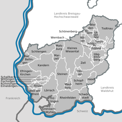
Communities
  |
||
|---|---|---|
| status | Surname | Residents |
| local community | Aitern | 534 |
| local community | Bad Bellingen | 4480 |
| local community | Binzen | 3046 |
| local community | Böllen | 100 |
| local community | Efringen churches | 8642 |
| local community | Eimeldingen | 2558 |
| local community | Fischingen | 791 |
| local community | Happy | 477 |
| local community | Grenzach-Wyhlen | 14,581 |
| local community | Häg-Ehrsberg | 851 |
| local community | hazel | 1108 |
| local community | Hausen in Wiesental | 2393 |
| local community | Inzlingen | 2508 |
| city | Kandern | 8249 |
| local community | Small meadow valley | 2869 |
| city | Loerrach , major district town | 49,347 |
| local community | Malsburg-Marzell | 1499 |
| local community | Maulburg | 4222 |
| city | Rheinfelden , large district town | 33,074 |
| local community | Rümmingen | 1870 |
| local community | Schallbach | 787 |
| local community | Schliengen | 5651 |
| city | Schönau in the Black Forest | 2420 |
| local community | Schönenberg | 345 |
| city | Schopfheim | 19,645 |
| local community | Schwörstadt | 2518 |
| local community | Stones | 10,049 |
| city | Todtnau | 4894 |
| local community | Tunau | 189 |
| local community | Utzenfeld | 622 |
| city | Weil am Rhein , large district town | 30,175 |
| local community | Wembach | 337 |
| local community | Wieden | 541 |
| local community | Whiting | 942 |
| city | Zell im Wiesental | 6325 |
Agreed administrative communities and municipal administration associations
- Agreed administrative partnership between the city of Kandern and the municipality of Malsburg-Marzell
- Agreed administrative partnership between the city of Lörrach and the municipality of Inzlingen
- Agreed administrative partnership between the city of Rheinfelden (Baden) and the community of Schwörstadt
- Agreed administrative partnership between the municipality of Schliengen and the municipality of Bad Bellingen
- Community administration association Schönau in the Black Forest with seat in Schönau in the Black Forest; Member communities: City of Schönau in the Black Forest and communities of Aitern, Böllen, Fröhnd, Schönenberg, Tunau, Utzenfeld, Wembach and Wieden
- Agreed administrative partnership between the city of Schopfheim and the communities of Hasel, Hausen im Wiesental and Maulburg
- Local government association “Vorderes Kandertal” based in Binzen; Member communities: Binzen, Eimeldingen, Fischingen, Rümmingen, Schallbach and Wittlingen
- Agreed administrative partnership between the city of Zell im Wiesental and the municipality of Häg-Ehrsberg
Until December 31, 2008, there was also the community administration association "Kleines Wiesental" based in Tegernau. The member communities were Bürchau, Elbenschwand, Neuenweg, Raich, Sallneck, Tegernau, Wies and Wieslet. With the formation of the unified community Kleines Wiesental, the municipal administration association Kleines Wiesental was dissolved.
Municipalities before the district reform
Before the district reform in 1973 or before the community reform , the (old) district of Lörrach had a total of 83 communities since 1936 , including six towns , with the district town of Lörrach being a major district town since April 1, 1956 .
On March 7, 1968, the state parliament of Baden-Württemberg set the course for a community reform . With the law to strengthen the administrative power of smaller municipalities , it was possible for smaller municipalities to voluntarily unite to form larger municipalities. It all started with the municipality of Fahrnau in the old district of Lörrach, which merged with the city of Schopfheim on July 1, 1971 . In the period that followed, the number of communities steadily decreased. On January 1, 1972, the community of Degerfelden was incorporated into the city of Rheinfelden (Baden) , district of Säckingen , and thus temporarily left the district of Lörrach. But on January 1, 1973, the city of Rheinfelden (Baden) became part of the new, enlarged district of Lörrach, which again includes all the communities in the old district of Lörrach.
The largest municipality in the old Lörrach district was the large district town of Lörrach . The smallest community was Böllen.
The old district of Lörrach last covered an area of 638 km² and had a total of 155,089 inhabitants at the 1970 census .
The table shows the population development of the old Lörrach district up to 1970. All population figures are census results.
|
|
The following is a list of the municipalities in the old Lörrach district before the municipal reform. All the communities still belong to the Lörrach district today.

Partnerships
-
 On October 3, 1990, a partnership was concluded with the Glauchau district , which was transferred to the Zwickau district in 2008 with the district reform .
 -
 The district of Lörrach has been working together with the Polish district of Lubliniec in eastern Upper Silesia since 1999 and deepened this with a partnership agreement in mid-2002.
License Plate
On July 1, 1956, the district was assigned the distinctive sign LÖ when the vehicle registration number that is still valid today was introduced . It is still issued today.
See also
literature
- The state of Baden-Wuerttemberg - official description according to districts and municipalities (in eight volumes); Edited by the Baden-Württemberg State Archives Department; Volume VI: Freiburg administrative region; Stuttgart 1982, ISBN 3-17-007174-2 .
- Wolfram Angerbauer: The district of Loerrach. In: Wolfram Angerbauer (Red.): The heads of the higher offices, district offices and district offices in Baden-Württemberg from 1810 to 1972 . Published by the working group of the district archives at the Baden-Württemberg district assembly. Theiss, Stuttgart 1996, ISBN 3-8062-1213-9 . Pp. 79-82
- Landesarchivdirektion Baden-Württemberg, Landkreis Lörrach (ed.): Der Landkreis Lörrach , Volume I (Aitern to Inzlingen), Jan Thorbecke Verlag Sigmaringen 1993, ISBN 3-7995-1353-1 .
- Department of State Description of the State Archives Freiburg im Breisgau: The district of Lörrach. Volume II: B. Community descriptions Kandern to Zell im Wiesental. Published by the Baden-Württemberg State Archives Directorate in conjunction with the Lörrach district. Jan Thorbecke Verlag Sigmaringen 1994, ISBN 3-7995-1354-X .
- District Office Lörrach (publisher): From Oberamt Rötteln to District Office Lörrach. Beginnings and historical development of the administrative structure 1382–1982 / 83 , Lörrach-Haagen 1983
- Karl Stiefel : Baden 1648–1952. Volume II, Karlsruhe 1979, pp. 1133-1145.
Web links
- Official web presence of the district
- Literature from and about the district of Lörrach in the catalog of the German National Library
- District of Lörrach - Statistical analysis of the district from June 1964
Individual evidence
- ↑ a b Statistisches Landesamt Baden-Württemberg - Population by nationality and gender on December 31, 2018 (CSV file) ( help on this ).
- ↑ Survey of land according to type of actual use in 2015
- ↑ LUBW protected area statistics ( Memento from January 20, 2015 in the Internet Archive )
- ^ Formally the county of Tyrol was not an imperial estate, but it was the highest administrative unit of the imperial estate of Austria responsible for the Breisgau
- ^ Supplement Lit. A: to the organizational rescript of November 26, 1809. In: Großherzoglich Regierungsblatt No. L of December 9, 1809, pp. 403-414; here p. 406; According to the organizational rescript, the new organization should be implemented by April 23, 1810 at the latest
- ^ Peace treaty of December 26, 1805 but protocol on the plowed land handover of April 15, 1806
- ^ Government Gazette of the Grand Duchy of Baden , No. 23 of July 7, 1807, pp. 93-100; here p. 95
- ^ Government Gazette of the Grand Duchy of Baden , No. 23 of July 7, 1807, pp. 93-100; here p. 95
- ^ Government Gazette of the Grand Duchy of Baden , No. 23 of July 7, 1807, pp. 93-100; here p. 95
- ^ Supplement Lit. A: to the organizational rescript of November 26, 1809. In: Großherzoglich Regierungsblatt No. L of December 9, 1809, pp. 403-414; According to the organizational rescript, the new organization should be implemented by April 23, 1810 at the latest
- ↑ Großherzoglich Baden Government Gazette of December 9, 1809, pp. 404-407
- ↑ Großherzoglich Badisches Staats- und Regierungs-Blatt 1832, pp. 133-134
- ^ Act concerning the organization of internal administration. V. From the district associations and the district associations. In: Grand Ducal Baden Government Gazette. No. XLIV. dated October 24, 1863
- ↑ Baden Law and Ordinance Sheet No. XXXI. dated July 30, 1864
- ↑ Baden Law and Ordinance Sheet No. 50 of 23 August 1923
- ↑ see Stiefel p. 1138
- ↑ Baden Law and Ordinance Sheet No. 11 of June 28, 1939
- ↑ Ordinance for the implementation of the district regulations of June 24, 1939. In: Badisches Gesetz- und Verordnungs-Blatt no. 11 of June 28, 1939
- ↑ see Stiefel p. 1139
- ↑ Ordinance No. 60 on the elections to the district assemblies in Baden of September 2, 1946. In: Official Gazette of the Baden State Administration. French occupation. No. 15 of September 20, 1946
- ↑ a b Federal Statistical Office (ed.): Historical municipality register for the Federal Republic of Germany. Name, border and key number changes in municipalities, counties and administrative districts from May 27, 1970 to December 31, 1982 . W. Kohlhammer, Stuttgart / Mainz 1983, ISBN 3-17-003263-1 , p. 498, 520 ff .
- ↑ Landkreis Lörrach: Final results of the district council election 2019 , accessed on April 27, 2020
- ↑ https://www.statistik-bw.de/Wahlen/Kommunal/02043000.tab?R=KR336 Result of the district election in Lörrach on May 26, 2019
- ↑ - ( Memento from September 4, 2014 in the Internet Archive ) Result of the district election 2014
- ↑ - ( Memento from September 4, 2014 in the Internet Archive ) Result of the district election 2009
- ↑ - ( Memento of September 4, 2014 in the Internet Archive ) Results of the district elections in 1999 and 2004
- ↑ [1] ( Page no longer available , search in web archives ) Info: The link was automatically marked as defective. Please check the link according to the instructions and then remove this notice. Distribution of votes in the district elections in 1989 and 1994
- ↑ [2] ( Page no longer available , search in web archives ) Info: The link was automatically marked as defective. Please check the link according to the instructions and then remove this notice. Distribution of seats in the district elections in 1989 and 1994
- ↑ Landkreisordnung für Baden-Württemberg (Landkreisordnung - LKrO) in the version of June 19, 1987. Section 3. District Administrator
- ↑ The designation Landrat had been used in Baden since 1924 for the heads of the district offices (previously Oberamtmann ). Announcement of September 20, 1924. Changes to the official designations. In: Badisches Gesetz- und Verordnungs-Blatt no. 54 of September 30, 1924, pp. 267–268
- ↑ District debts according to core households and own businesses. see homepage of the State Statistical Office; accessed on March 3, 2018
- ↑ Future Atlas 2016. (No longer available online.) Archived from the original on October 2, 2017 ; accessed on March 23, 2018 . Info: The archive link was inserted automatically and has not yet been checked. Please check the original and archive link according to the instructions and then remove this notice.
- ↑ PROGNOS future atlas. Handelsblatt, accessed on December 10, 2019 .
- ^ Partnership agreement between the districts of Glauchau and Lörrach. (PDF) (No longer available online.) October 3, 1990, formerly in the original ; accessed on August 18, 2015 . ( Page no longer available , search in web archives ) Info: The link was automatically marked as defective. Please check the link according to the instructions and then remove this notice.
- ↑ Partnership between the district of Lubliniec and the district of Lörrach ( Memento from October 8, 2007 in the Internet Archive )
Alb-Danube District | Baden-Baden | Biberach | Lake Constance district | Boeblingen | Breisgau-Upper Black Forest | Calw | Emmendingen | Enzkreis | Esslingen | Freiburg im Breisgau | Freudenstadt | Göppingen | Heidelberg | Heidenheim | Heilbronn (Land) | Heilbronn (city) | Hohenlohekreis | Karlsruhe (State) | Karlsruhe (city) | Constance | Loerrach | Ludwigsburg | Main-Tauber district | Mannheim | Neckar-Odenwald district | Ortenaukreis | Ostalbkreis | Pforzheim | Rastatt | Ravensburg | Rems-Murr-Kreis | Reutlingen | Rhein-Neckar District | Rottweil | Schwäbisch Hall | Schwarzwald-Baar district | Sigmaringen | Stuttgart | Tübingen | Tuttlingen | Ulm | Waldshut | Zollernalb district
.svg)
Basking | Backnang | Baden-Baden | Balingen | Biberach | Boeblingen | Bruchsal | Book | Bühl | Calw | Crailsheim | Donaueschingen | Ehingen | Emmendingen | Esslingen | Freiburg (city) | Freiburg (State) | Freudenstadt | Friedrichshafen | Göppingen | Hechingen | Heidelberg (city) | Heidelberg (Country) | Heidenheim | Heilbronn (city) | Heilbronn (Land) | Black Forest | Horb | Karlsruhe (city) | Karlsruhe (State) | Throat | Constance (city) | Constance (Country) | Künzelsau | Lahr | Leonberg | Loerrach | Ludwigsburg | Mannheim (city) | Mannheim (State) | Mergentheim | Mosbach | Muellheim | Münsingen | Neustadt | Nürtingen | Offenburg | Öhringen | Pforzheim (city) | Pforzheim (Country) | Rastatt | Ravensburg | Reutlingen | Rottweil | Säckingen | Saulgau | Schwäbisch Gmünd | Schwäbisch Hall | Sigmaringen | Sinsheim | Stockach | Stuttgart | Tauberbischofsheim | Tettnang | Tübingen | Tuttlingen | Überlingen | Ulm (city) | Ulm (State) | Vaihingen | Villingen | Villingen-Schwenningen | Waiblingen | Waldshut | Cheeks | Wolfach