
German Limes Cycle Route
| German Limes Cycle Route | |
|---|---|

|
|
| overall length | 818 km |
| location |
|
| map | |

|
|
| Course of the German Limes cycle path | |
| Starting point | Bad Hönningen ( Bf ) |
| Target point | Regensburg ( Bf ) |
| Places along the way | Neuwied ( Bf ), Bendorf , Höhr-Grenzhausen , Bad Ems ( Bf ), Marienfels , Heidenrod , Bad Schwalbach , Niedernhausen , Idstein , Glashütten , Butzbach ( Bf ), Hungen ( Bf ), Altenstadt ( Bf ), Erlensee , Großkrotzenburg ( Bf ), Seligenstadt ( Bf ), Aschaffenburg ( Bf ), Miltenberg ( Bf ), Amorbach ( Bf ), Walldürn ( Bf ), Osterburken ( Bf ), Jagsthausen , Öhringen ( Bf ), Murrhardt ( Bf ), Welzheim , Schwäbisch Gmünd ( Bf ), Essingen , Aalen ( Bf ), Gunzenhausen ( Bf ), Ellingen ( Bf ), Weißenburg in Bayern ( Bf ), Kipfenberg , Altmannstein , Weltenburg , Kelheim ( Bf ), |
| Flooring | mostly paved |
| Height difference | between 58 m and 770 m / about 8836 Hm rises about 8722 Hm downhill |
| difficulty | approx. 45% easy, 45% medium, 9% difficult, 1% athletic (according to ADFC classification) |
| Traffic volume | 97% none to little, 2% moderate, 1% high (mostly car-free) |
| Connection to |
Rhine Cycle Path (EV15) , Lahntal Cycle Path , Main Cycle Path , Danube Cycle Path (EV6, D-Route 6) , Via Danubia |
| Website URL | limesstrasse.de |
The German Limes Cycle Route is an approximately 818 kilometer long cycle route between the Rhine and Danube . It follows the Upper Germanic-Rhaetian Limes , a Roman border wall from the first or second century. Chr., Since 2005 a World Heritage Site of UNESCO is.
The Limes cycle path runs through the four federal states of Rhineland-Palatinate , Hesse , Baden-Württemberg and Bavaria ; it crosses the nature parks Rhein-Westerwald , Nassau , Rhein-Taunus , Swabian-Franconian Forest and Altmühltal . Since the cycle path mostly runs through quiet, untouched areas away from major cities, it is recommended not only to those interested in history but also to nature lovers. The route is very mountainous and can therefore not be recommended for inexperienced people and families with children.
Characteristic
The Limes cycle path connects numerous sights along the Upper German-Raetian Limes. This includes reconstructed watchtowers and forts as well as other preserved or reconstructed Limes structures. It also leads to various Roman and Limes museums. There are interesting cities, castles and palaces as well as charming landscapes along the way.
The condition of the paths ranges from very good for paved river bike paths to extremely poor for washed-out gravel paths with enormous inclines. Since the signs are partially missing, a map or GPS should be taken with you. The German Limes Road and, in some sections, the Limes hiking trails run more or less parallel , so that there are always alternative routes. Some sections of the Limes cycle path ( Taunus , Swabian Forest ) are very demanding in terms of altitude. The most suitable for the route is a touring bike with gearshift suitable for mountains. Since the route is largely well developed in terms of traffic, the Limes cycle path can also be easily ridden in sections.
According to ADFC information are:
- The degree of difficulty: approx. 45% easy, 45% medium, 9% difficult, 1% sporty
- The nature of the route: approx. 40% suitable for road bikes, 60% touring bikes are recommended
- The traffic load: approx. 97% no to low, 2% moderate, 1% high
- Ideal for children: 6%
Route
Section Bad Hönningen – Bendorf
ADFC information:
31.0 km; uphill 494 meters of altitude (m); downhill 431 m ; Low mountain range
Difficulty level: approx. 14% easy, 70% medium, 16% difficult
Route characteristics: Touring bike recommended
Traffic load : no to low
The route has an ascent of almost 300 meters from the Rhine Valley. After about twelve kilometers, the route to Neuwied-Rodenbach drops back almost to the starting level and leads slightly hilly to the destination of the section. The route starts in Bad Hönningen , where the small fort Rheinbrohl and the RömerWelt are located at Caput Limitis , the beginning of the Upper German Limes, and leads on the district road K1 past the small fort “Am Forsthofweg” to Rodenbach, 17 kilometers away . The preserved remains of the Niederbieber fort are located between Rodenbach and Oberbieber . On the country road L260 on the Neuwieder neighborhoods Gladbach and Heimbach-Weis is Bendorf reached. Worth seeing are the double church Medardus and St. Medard , the Sayner hut , the Sayn castle and the Sayn abbey .
Section Bendorf – Kemmenau
ADFC information:
38.3 km; uphill 846 m; downhill 603 m;
Low mountain range
Difficulty level: approx. 80% medium, 20% difficult
Route characteristics: Touring bike recommended
Traffic load : no to low, less than 1% moderate
In Bendorf the route starts with an ascent of around 200 meters in altitude, then continues uphill through the Westerwald, before another 200 meters in altitude have to be overcome with the final ascent before Kemmenau. After Bendorf, the route runs past the Westerwald Ceramics Museum and after 14 kilometers reaches the center of Höhr-Grenzhausen . The next village is Hillscheid , only a few reconstructed remains of the small fort there can be seen. Shortly before Hillenbach a Limes tower was reconstructed. Then it goes through the villages of Neuhäusel and Eitelborn to Arzbach , on the southern edge of which is the no longer visible ground monument Fort Arzbach . Then a ridge with about 220 meters of altitude has to be overcome on the K2 district road before Kemmenau is reached.
Section Kemmenau – Marienfels
ADFC information:
27.5 km; uphill 429 m; downhill 603 m; Low mountain range
Difficulty level: approx. 55% easy, 4% medium, 41% difficult
Route characteristics: Touring bike recommended
Traffic load : no to low
The section starts with a descent of around 330 meters in altitude to Bad Ems in the Lahn valley . After a short stretch along the Lahn, the route climbs the heights of the Taunus, with about 300 meters of altitude to be mastered to Schweigenhausen. Then the path falls to the destination Marienfeld. From Kemmenau the route leads down the state road L327 into the Lahn valley and into the spa town of Bad Ems, which is reached after around three kilometers. Passing the city palace , the path reaches the center. At the time of the Romans, two forts secured the Lahn crossing. The Ems fort and the small fort on the Schanz , of which nothing has survived , were located in the inner city area . Roman finds are shown in the city museum. Since the Middle Ages, Bad Ems has developed into one of the most important spas in Germany and has an impressive spa architecture. In addition to Germany's largest flower parade, there is an annual music festival. After a short section on the Lahn, the Limes cycle path crosses the river and branches off at Nievern with the K65 district road to the south into the Taunus. Shortly before the village of Schweighausen , the route leads past the former small fort Becheln , which only exists as a no longer visible ground monument. After the 300 meter ascent to Schweighausen, the route descends to Marienfels in the Mühlbachtal, 150 meters lower .
Marienfels – Adolfseck section
ADFC information:
32.7 km; uphill 614 m; downhill 536 m; Low mountain range
Difficulty level: approx. 8% easy, 78% medium, 14% difficult
Route characteristics: Touring bike recommended
Traffic load : no to low
The height profile of the section is characterized by two climbs. The first ascent from Marienfels out of the Mühlbachtal overcomes around one hundred meters in altitude over a kilometer, then slowly climbs again over twelve kilometers by 100 meters and overcomes another hundred meters on the last kilometer. The highest point is reached at the gray head behind Grebenroth . The second ascent leads from Laufenselden over about five kilometers and 55 meters in altitude to Huppert. The first village on the section is Pohl , about five kilometers behind Marienfels, where the historic Pohl Fort is located, which has only been preserved as a ground monument. A replica of the fort was opened near it in October 2011. Three kilometers further on is Holzhausen an der Haide , in whose forests the Holzhausen cohort fort is located at an average of 495 meters above sea level on the north-western slope of the Grauer Kopf , at 543.4 meters above sea level. NN second highest mountain in the western Hintertaunus. It is one of the best preserved Limes forts in Germany and can be recognized as a well-preserved ruin. It can be reached from Holzhausen via the Limes hiking trail. The cycle path runs south of the Grauer Kopf past the fort to Laufenselden and on to Huppert, 15 kilometers away . There was the small fort "Auf dem Dörsterberg" , where a Limes palisade was reconstructed (approx. 300 m south of the cycle path). Then the route reaches Heidenrod-Kemel , where the former Kemel fort is largely built over. Past the Villa Lilly the route leads into the Aartal to Adolfseck with the Adolfseck Castle and the small fort Adolfseck , which is only an invisible ground monument.
Section Adolfseck – Dasbach
ADFC information:
23.7 km; uphill 461 m; downhill 422 m; Low mountain range
Difficulty level: approx. 20% easy, 62% medium, 18% difficult
Route characteristics: Touring bike recommended; 4% also suitable for
road bikes Traffic load : approx. 95% no to low, 5% moderate
This section begins with a steep climb over two kilometers and 230 meters in altitude. After that, the route becomes a little flatter and then climbs another 60 meters over 3.5 kilometers. This is followed by an 11 km long hilly section before the route leads with an altitude of 200 meters into the Idsteiner Senke . There is an ascent of 60 meters before the final destination. The Zugmantel fort was about halfway near the village of Orlen on federal road 417 . About one kilometer east of the archaeological monument there is a reconstructed stone watchtower along with a piece of Limes with a palisade. The route then leads through the Rhein-Taunus Nature Park, past the Hohen Kanzel , the Engenhahn Wildlife Park and under the motorway bridge of the BAB 3 to Niederseelbach , then via Oberseelbach to Dasbach . There is the Römerturm Idstein-Dasbach at L3026 , a reconstruction from 2002. In the opinion of historians it is the most authentic reconstruction of a Roman watchtower from the time from 150 AD. In the tower there is a small exhibition on the subject of The Romans in the Taunus .
Dasbach – Langenhain section
ADFC data:
43.9 km; uphill 521 m; downhill 787 m; Low mountain range with sliding passages Degree of
difficulty: approx. 22% easy, 58% medium, 17% difficult, 3% sporty
Route characteristics: Touring bike recommended
Traffic load : none to low
This section is very demanding with an ascent of over 455 meters between the lowest point in front of Schloßborn and the Altes Jagdhaus fort. Almost the entire section leads through the forests of the Hochtaunus . After Dasbach, the route leads to Alteburg Castle , where only faint traces of soil can be seen. The Alteburger Markt is held three times a year on the site. The route continues via Schloßborn to Glashütten . There is nothing to be seen on the surface of the small fort there . The route then continues to climb and leads north of the Kleiner Feldberg to the fort there . With its altitude of more than 700 meters above sea level, it is the highest fort on the entire Upper German-Raetian Limes. It was extensively restored in 2004 and 2005. The route then runs past the Großer Feldberg to the Altes Jagdhaus small fort on the Taunus ridge. The fort and the hunting lodge built in it in the 16th century were preserved in 2009, so that the complex can be seen through an earth wall and the foundations of the hunting lodge in it. The Heidenstock small fort is located off the bike path and can be reached from Sandplacken via the Taunus circular path . Remnants of the foundation walls can still be seen. The route descends and reaches the most famous building of the Germanic Limes, the Saalburg . Over a decade to 1907, the most complete reconstruction of a fort on the entire Limes was carried out, which, along with the Saalburg Museum, is probably the most important institution of its kind for German Limes research alongside the Aalen Limes Museum. The further path leads after two kilometers to the Saalburgsiedlung with the small fort Lochmühle , which has hardly any traces left, and on to the small fort Kaisergrube . The fort is barely recognizable, but a stone watchtower was reconstructed on the nearby Gaulskopf , which the cycle path leads past. The route then reaches the destination Langenhain-Ziegenberg with its Ziegenberg Castle and Langenhain Castle (not visible).
Section Langenhain – Grüningen
ADFC information:
26.9 km; uphill 384 m; downhill 344 m; Low mountain range
Difficulty level: approx. 9% easy, 91% medium
Route characteristics: Touring bike recommended; 10% also suitable for
road bikes Traffic load : approx. 91% no to low, 9% moderate
The section is located in the transition area between Taunus and Wetterau . As far as Butzbach, the route is still mountainous with three ridges between 50 and 150 meters above sea level, after which there are only easier climbs to Grüningen. With the next village Wiesental the city of Butzbach is already reached. After the other districts of Fauerbach vor der Höhe and Hoch-Weisel , the core town of Butzbach forms roughly the middle of the section. There is nothing left of the former fort in the city center . As recently as the middle of the 17th century, a clearly visible complex was reported. The remains, which were used as a cheap quarry, were mistaken for a castle belonging to the Hun King Attila, hence the name Hunnenburg. In the city's museum there is a model of the Hunnenburg, which was larger than the restored Saalburg. The old town around the market square is also worth seeing. The next Roman traces are at the small fort in Holzheimer Unterwald . The foundation walls of the fort were preserved and partially reconstructed. About a kilometer to the north-east, behind a forest, a watchtower with a limes section was reconstructed. Shortly thereafter, Grüningen is reached.
Section Grüningen – Reichelsheim
ADFC information:
38.1 km; uphill 227 m; downhill 349 m
Difficulty level: approx. 48% easy, 52% medium
Route characteristics: touring bike recommended; 20% also suitable for
road bikes Traffic load : no to low
This section is relatively flat with two easy climbs of about 50 meters. After crossing the BAB 5 , the route reaches the ruins of the former Cistercian abbey in Arnsburg in the Wetter Valley and shortly afterwards with the town of Muschenheim the urban area of Lich . After the districts of Birklar and Bettenhausen , the route leads near the small fort Feldheimer Wald , of which only a flat bump is left. Overall, the remains of the Limes in the Wetterau have been almost completely eroded by the centuries of agriculture there. About two kilometers later the town of Hungen with its remarkable Hungen Castle is reached. The cycle path then continues south to the Inheiden district and Lake Trais-Horloffer . The former Inheiden fort , which is no longer visible, remains on the left. The route continues southwards via the Hungen districts of Steinheim and Unter-Widdersheim , which is part of the town of Nidda , to Echzell . There were two forts, the Haselheck and Echzell fort , of which no traces can be seen above ground. However, the local history museum shows local finds and a giant Jupiter column has been reconstructed in front of the museum , and the foundation walls of the fort bath at the church have also been made visible. The route then leads to Echzell-Bingenheim with Bingenheim Castle and past the small fort Lochberg , which is no longer recognizable , before reaching the end of the section with Reichelsheim in the Wetterau.
Section Reichelsheim – Marköbel
ADFC data:
22.9 km; uphill 195 m; downhill 188 m
Difficulty: approx. 47% easy, 53% medium
Route characteristics: touring bike recommended; 4% also suitable for
road bikes Traffic load : no to low
On this section there is a major ascent of around 100 meters behind Staden before the descent to Altenstadt begins. After Reichelsheim the route reaches Florstadt-Staden with Löw's castle and the small fort Staden, which is no longer recognizable . With its many bridges over the Mühlbach and the Nidda , the town is known by its residents as "Little Venice". The next town on the route is Florstadt-Stammheim with Stammheim Castle and the Stammheim small fort, which has only survived as a ground monument . After overcoming a ridge, the route reaches Altenstadt with its Altenstadt castle , which is no longer recognizable above ground . With its first documentary mention in 767, it is considered one of the oldest communities in Upper Hesse . The cycle path continues in a southerly direction and reaches the ground monument of the small fort "Auf dem Buchkopf" . A section of palisade was reconstructed on the L3347 road to Rommelhausen. At the destination in Hammersbach-Marköbel , there was another stone fort, the Marköbel fort , which is now overbuilt . The Lower Gate and the half-timbered town hall are also worth seeing in Marköbel.
Marköbel – Seligenstadt section
ADFC information:
28.7 km; uphill 128 m; downhill 150 m
Difficulty: approx. 85% easy, 15% medium
Route characteristics: Touring bike recommended; 1% also suitable for
road bikes Traffic load : approx. 98% no to low, 2% moderate
This section is largely flat except for an ascent of approx. 50 meters at the beginning of the section. The route continues in a southerly direction via the village of Ravolzhausen to Erlensee , where the now overbuilt small fort Langendiebach was located. Shortly afterwards, the route arrives at the Rückingen district, where the foundations of the fort baths of the former Rückingen fort have been reconstructed and provided with information boards. In the village there is also the Rückingen moated castle , which houses a local museum. After crossing the BAB 66 , the route leads past the ruins of the former Servite monastery in St. Wolfgang and the Wolfgang hunting lodge . The route then crosses the BAB 45 and reaches the Neuwirtshaus small fort , which is only evidenced by deformations of the terrain and a notice board. After another three kilometers, Großkrotzenburg and the Main are reached. The foundation walls of two towers and parts of the fort wall were reconstructed from the Großkrotzenburg fort , which was built over in the Middle Ages . South of Grosskrotzenburg the Main formed as so-called Main Limes or "Wet Limes" the border to the Fort Wörth ( Odenwald Limes ) or Kastell Miltenberg-Ost (younger Odenwald line). At the Krotzenburg barrage , the Limes cycle path crosses the Main and, together with the Main cycle path, leads to Seligenstadt . Nothing can be seen of the former cohort fort on today's market square. In Seligenstadt, the Einhard Basilica of St. Marcellinus and Petrus with the attached former monastery and the old town are particularly worth seeing.
Seligenstadt – Miltenberg section
ADFC information:
58.4 km; uphill 204 m; downhill 187 m; River cycle route Degree of
difficulty: approx. 99% easy, 1% medium
Route characteristics: Touring bike recommended; 70% also suitable for
road bikes Traffic load : no to low
This section along the Main is largely flat. The route follows the Main Cycle Path for another four kilometers until it changes to the right bank in Mainflingen , while the Limes Cycle Path remains on the left bank. Shortly after Seligenstadt, the beautiful Seligenstadt moated castle can be visited, which is about 200 meters south of the cycle path. After crossing under the BAB 3 , the Limes cycle path in Stockstadt am Main also changes to the right side of the Main and leads together with the Main cycle path to Aschaffenburg . There was also a fort in Stockstadt, but only a notice board on Obernburger Strasse reminds of it. In Aschaffenburg, the cycle path passes below the Pompejanum and Johannisburg Castle , before changing the banks of the Main with the Main cycle path. The Niedernberg fort was found in the village of Niedernberg , but there are no traces of it above ground. In the center of the village, markings in the pavement mark the location of the former gate tower foundations. The route leads via Großwallstadt to Obernburg am Main . The fort documented there is also completely overbuilt. In the Römermuseum Obernburg mainly finds from the former fort are shown. A giant column of Jupiter was reconstructed in front of the building . The old town of Obernburg is also worth seeing. The next town on the route is Wörth am Main . The function of the fort found there is unclear, as the transition to the Odenwald line has not yet been determined. In the city there is the shipping and shipbuilding museum , which documents the historical development of inland shipping and shipbuilding on the Main, as well as the beautiful old town. The route to Miltenberg am Main leads through the villages of Trennfurt , Laudenbach and Kleinheubach with its Löwenstein Castle . Before the Laurentiuskapelle it branches off to the southwest and follows the valley of the Mud . If you want to visit the historic old town of Miltenberg, you can reach it on the Main cycle path in about one kilometer.
Miltenberg – Walldürn section
ADFC information:
15 miles; uphill 361 m; downhill 108 m; Low mountain range
Difficulty level: approx. 37% easy, 63% medium
Route characteristics: Touring bike recommended; 72% also suitable for
road bikes Traffic load : none to low
The section rises again; Only easy to Schneeberg, then stronger to Walldürn (200 meters in altitude over 11 kilometers). With the 3-country cycle path , the Limes cycle path leads via Weilbach to Amorbach . In Amorbach the former Benedictine monastery Amorbach , the Templar House and the Fürstlich-Leiningen Palace are worth seeing. The destination of the section, the Walldürn pilgrimage site , is reached via a steeper ascent via the villages of Schneeberg and Rippberg . In the historic old town, the pilgrimage basilica of St. George , the town hall and the former castle are particularly worth seeing.
Walldürn – Leibenstadt section
ADFC information:
34 km; uphill 328 m; downhill 457 m, low mountain range
Difficulty level: approx. 58% easy, 42% medium
Route characteristics: Touring bike recommended; 56% also suitable for racing bikes
Traffic load : approx. 99% no to low; 1% high
This section is very hilly. The route leads to Osterburken with two easy climbs, before a steep ascent of approx. 100 m. Then it goes very hilly to the section destination. About 6.5 km after Walldürn, the route reaches the Hönehaus small fort in a forest area shortly after crossing the 518 road . Significant traces of conservation of the fence are visible from it. The next known fort is the small fort in Rinschheim . It was near the village of Buchen-Rinschheim , but can no longer be seen on the surface because the area is used for agriculture. After Götzingen and Bofsheim the route reaches Osterburken , where there was also a fort . Some of the remains are still visible and preserved. The fort bath was integrated into the Römermuseum Osterburken after its exposure . After the expansion in 2006, it was reopened as a supraregional Limes information center and branch of the Archaeological State Museum Baden-Württemberg . The route is very hilly for the last 11 km through meadows, fields and forests as well as two hamlets to the section destination Adelsheim-Leibenstadt .
Leibenstadt – Öhringen section
ADFC information:
27.2 km; uphill 566 m; downhill 611 m; Low mountain range
Difficulty level: approx. 58% easy, 30% medium, 12% difficult
Route characteristics: Touring bike recommended; 99% also suitable for
road bikes Traffic load : approx. 98% no to low; 2% moderate or high
This mountainous, demanding section contains three climbs of over 100 meters in altitude. The route leads on the district roads K2952 and K2022 over the BAB 81 and through the village of Unterkessach in the valley of the Kessach to Jagsthausen on the lower reaches of the Jagst . The archaeological monument and open-air museum Römerbad Jagsthausen is located in the center of the village . The associated Roman cohort fort Jagsthausen was located about 400 meters from the Limes, in the area of today's parks of the White Palace and the Jagsthausen Castle and the northern town center of Jagsthausen . From there the route leads over the hamlet of Edelmannshof, which is 140 meters above sea level above Jagsthausen, to Kocher in Sindringen , about 6 kilometers away, with the small fort there , of which nothing is visible on the surface. The route leaves the Kochertal and continues south through the village of Zweiflingen -Pfahlbach (160 vertical meters ascent) and Zweiflingen-Wersternbach after crossing the BAB 6 to the Öhringen section destination in the flat valley of the Ohrn . The city has a medieval market square, where the former Hohenlohe castle is located together with the collegiate church , the city's landmark . There were two Roman castles in the area of the city.
Section Öhringen – Murrhardt
ADFC information:
40.2 km; uphill 598 m; downhill 541 m; Low mountain range
Difficulty level: approx. 52% easy, 41% medium, 7% difficult
Route characteristics: Touring bike recommended; 74% also suitable for racing bikes
Traffic load : approx. 79% no to low; 21% moderate
The demanding section is characterized by three climbs. The first, flatter one, overcomes almost 240 meters in altitude over 6.5 kilometers, the two steeper ones have height differences of almost 150 and 100 meters over around 2.5 kilometers. The first ascent leads through mostly open terrain over Heuberg , Buchhorn and Unterleichen , past the Gleichener See to Frohnfalls, which belongs to the municipality of Mainhardt . Then the valley of the Brettach is crossed and the climatic health resort Mainhardt reached after the ascent from the valley. The municipality is crossed by the often clearly recognizable Limes, which is followed by a signposted hiking trail. A little west of the hamlet of Seehäuser, a publicly accessible watchtower in the style of Roman wooden watchtowers was built at the former Römergraben café on the Limes route, which is still clearly visible there, but which does not correspond to the historical model. There are no traces of the former small fort on the surface. After Mainhardt, the Rottal is crossed, in which the small fort Hankertsmühle is located. With the village of Grab , the ascent from the Rottal is done and the route still leads through a depression before the section destination Murrhardt is reached after the descent into Murrtal . The small town is located in the heart of the Swabian Forest on the Idyllic Road . The fort Murrhardt was in the east of the city and was built over in the second half of the 20th century. Worth seeing in Murrhardt are the old town and the town church , which originally served as a monastery church .
Murrhardt – Lorch section
ADFC information:
36.4 km; uphill 541 m; downhill 539 m; Low mountain range
Difficulty level: approx. 54% easy, 36% medium, 10% difficult
Route characteristics: Touring bike recommended; 75% also suitable for
road bikes Traffic load : approx. 74% no to low; 24% moderate
This section leads over the heights of the Murrhardt Forest and is accordingly demanding. Up to the Ebnisee, about in the middle of the section, you have to overcome 300 meters in altitude before you go mainly downhill to Lorch. The ascent runs in a wide arc through mostly open terrain to the hamlet of Althütte -Fautspach and then through a forest area to the Ebnisee. The lake was created in the 18th century as a threshold pond for rafting and is now mainly used for local recreation. About two kilometers behind the lake on the L1150 is the small fort Ebnisee , the remains of which are difficult to see in the forest. The cycle route then runs on the L1150 to Welzheim . Before Welzheim there was the small fort Rötelsee . It was conserved for the public after the scientific excavation in the autumn of 1974, so the course of the trench is visible, the interior development was indicated by concrete slabs. There were two other forts in Welzheim . The west fort was completely built over, while the east fort was partially reconstructed and in 1993 an archaeological park was added. The route now leads past the Eisenbach and Leineck flood retention basins to Alfdorf-Pfahlbronn . The route reaches its destination Lorch in the Remstal via a descent of approx. 200 meters in altitude, mainly through the forest . The main attraction of the city is the Lorch Abbey on the Klosterberg. Next to the monastery buildings, a replica of a wooden Roman watchtower is reminiscent of the Limes. The block construction shown there was atypical for Roman wooden structures.
Lorch – Aalen section
ADFC data:
35.9 km; uphill 299 m; downhill 157 m
Difficulty: approx. 74% easy, 26% medium
Route characteristics: Touring bike recommended; 95% also suitable for
road bikes Traffic load : approx. 98% no to low; 2% moderate
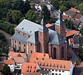
The elevation profile of the section is mainly characterized by the long ascent to Essingen with about 190 meters of altitude. The last six kilometers to Aalen then lead downhill. The route follows the Rems from Lorch to Schwäbisch Gmünd , passing the Rotenbachtal , where the provincial border between Upper Germany and Raetia ran, and the Schirenhof fort . In the course of the redesign of the fort area of Freimühle , the older palisade and the younger Rhaetian wall were reconstructed in the Rotenbachtal south of the historical border. The Schierenhof Fort is located south of the Rems. The fort square is largely built over, but the fort bath has been preserved, whereby the course of the foundation walls is visible. In the city of Schwäbisch Gmünd, six fortified towers are still preserved from the city wall from the 14th century. The numerous churches, monasteries and chapels gave the Catholic imperial city the reputation of a "Swabian Nazareth" early on. The largest church and the symbol of the city is the Heilig-Kreuz-Münster . The route continues along the Rems and reaches Böbingen an der Rems , where there was a fort , parts of which have been preserved and are visible. Still following the Rems, Essingen is reached via Mögglingen . There is the apex of the section and the route leads down to Aalen in the upper Kochertal with its fort and the Limes Museum . It is the largest museum on the Upper Germanic-Raetian Limes and is located on the site of what was once the largest cavalry fort north of the Alps. Also worth seeing in Aalen are the historic market square with the old town hall and the Protestant town church of St. Nicholas, which dominates the city center .
Section Aalen – Großlellenfeld
ADFC information:
72.2 km; uphill 590 m; downhill 500 m
Difficulty: approx. 46% easy, 54% medium
Route characteristics: Touring bike recommended; 55% also suitable for
road bikes Traffic load : no to low
The section mostly climbs the first 25 km to Stödtlen -Gerau, which is approx. 120 m above sea level. The descending or level stretch that then begins is only interrupted by a notable incline near Wittelshofen . The first seven kilometers of the route run flat in the Kocher valley to Hüttlingen , where the valley is left in a north-westerly direction. Before Rainau- Buch, where there is a partially preserved fort with display boards, there is a knoll with about 60 m. The next find on the way is the Limestor Dalkingen in front of the village of Dalkingen . The route then crosses the BAB 7 and via Röhlingen reaches the village of Pfahlheim and a little later Ellwangen-Halheim , where the contour of the fort there has been made visible through planting. The cycle route to Wilburgstetten an der Wörnitz leads through several small villages . This is followed by the cycle path via Weiltingen to the Ruffenhofen Roman Park on the site of the former fort . As far as Wittelshofen , the route follows the Wörnitz and then leaves the valley with the Sulzach in order to reach Ehingen via fields and meadows and shortly thereafter to reach the Dambach district , where the Dambach fort was located, of which nothing can be seen above ground today. The cycle path now runs on the edge of a forest area to Lake Dennenloher and shortly afterwards to the destination Großlellenfeld , a district of Arberg .
Section Großlellenfeld – Weißenburg
ADFC information:
40.6 km; uphill 374 m; downhill 281 m; Franconian Lake District Degree of
difficulty: approx. 43% easy, 63% medium,
route characteristics: touring bike recommended; 56% also suitable for
road bikes Traffic load : approx. 68% no to low, 32% moderate
The elevation profile of the section is characterized by a slight and a steeper ascent to Thannhausen . The route leads alternately through fields, meadows and forests, past the Altmühlsee to Gunzenhausen with its former fort , the partially preserved city fortifications and the historic market square, which is characterized by baroque buildings. The Roman fort is completely built over. A section between two former watchtowers was conserved and partially reconstructed by the Bavarian State Office for Monument Preservation . After the district of Frickenfelden , the route leaves the city and reaches Fort Theilenhofen , which is visible through replanting and whose bath has been partially reconstructed. The finds from the excavation are in the Museum of Prehistory and Early History in Gunzenhausen , in the Archaeological State Collection in Munich and in the Germanic National Museum in Nuremberg . Behind Theilenhofen , the cycle route continues through a varied landscape and several hamlets to the village of Gündersbach , near which there was another small fort on which no excavations have yet been carried out. Only a few kilometers later the town of Ellingen is reached, the townscape of which was largely shaped by the work of the Teutonic Order and has the stylistic unity of a small baroque residence . The highlights are the Ellingen residence , the town hall and the parish church of St. Georg . The route leaves the city in a southerly direction and shortly afterwards reaches the section destination Weißenburg in Bavaria . The former Biriciana fort was partially reconstructed, the associated thermal baths were discovered in 1988 and converted into a museum. The Roman Museum focuses on the prehistoric and early historical cultures of the region. The entire historic old town is listed. The cityscape is characterized by late medieval half-timbered houses and baroque town houses. Particularly noteworthy are the Ellinger Tor and St. Andrew's Church .
Weißenburg – Kipfenberg section
ADFC information:
40.7 km; uphill 407 m; downhill 442 m
Difficulty level: approx. 31% easy, 64% medium, 5% difficult
Route characteristics: Touring bike recommended; 33% also suitable for
road bikes Traffic load : approx. 98% no to low, 2% moderate
The section is characterized by a long ascent to Oberhochstatt with approx. 130 meters of altitude and then again by a shorter, steeper incline with approx. 60 meters of altitude in the last third of the section, before the route leads steeply down to the section destination Kipfenberg in Altmühltal . On the start of the ascent you look in a southerly direction to the Hohenzollern fortress Wülzburg and drive through the two Weißenburg districts Niederhofen and Oberhochstatt. In the local fort there were no excavations. The route then passes the two forts “In der Harlach” and Raitenbuch , and then follows the ancient course of the Limes between Petersbuch and Erkertshofen , where there is a reconstructed watchtower behind Erkertshofen. The cycle path now enters a large forest area, crosses a side valley of the Altmühl, and reaches the section destination Kipfenberg via the villages of Hirnstetten and Pfahldorf . The place is dominated by the medieval castle Kipfenberg . The Roman and Bavarian Museum Burg Kipfenberg with the Limes InfoPoint is housed in one of their farm buildings.
Section Kipfenberg – Eining
ADFC information:
39.3 km; uphill 294 m; downhill 326 m
Difficulty: approx. 35% easy, 54% medium, 11% difficult
Route characteristics: Touring bike recommended; 55% also suitable for
road bikes Traffic load : no to low
This section also has a more sporty character due to two larger climbs. From the Altmühltal about 150 meters of altitude have to be conquered and after Altmannstein another 50 meters. The route leads from the Altmühltal past the Kipfenberg castle, passes the Gelbelsee transmitter and a short time later turns in the village of Gelbelsee with the BAB 9 heading southwest to Denkendorf . There it turns back to the west, crosses the BAB 9 and reaches the municipality of Altmannstein with the two hamlets of Breitenhill and Megmannsdorf via the district of Zandt . The route then continues to the west with a southerly offset through a larger forest area. The two small forts Güßgraben and Hinterer Seeberg are located in this forest south of the route . The route then reaches Altmannstein-Schamhaupten in the Riedenburger Schambachtal . Following the valley, it reaches the Altmannstein market via the districts of Sandersdorf with its castle , Neuenhinzenhausen and Sollern . With the county road E130, the route leaves the main village and the valley and passes through the Altmann Steiner districts Hagen Hill and Laimerstadt after Hienheim on the Danube. The ferry connects with the section destination Eining , which belongs to the city of Neustadt an der Donau . The foundation walls of the former Roman fort are still there.
Section Eining – Oberndorf
ADFC information:
33.5 km; uphill 247 m; downhill 257 m; River Cycle Path Degree of
difficulty: approx. 89% easy, 6% medium, 5% difficult
Route characteristics: Touring bike recommended; 38% also suitable for racing bikes
Traffic load : approx. 94% no to low, 6% moderate
The section described by the ADFC leads between Weltenburg Abbey and Kelheim via the St2233 district road and has to overcome 130 meters in altitude there. This section is much less strenuous to cover by boat on the Danube. Then the section is largely flat. The route leads on the Danube Cycle Path to Weltenburg . Here you can decide whether to take the route over the ridge above the Danube or to go to Weltenburg Monastery , from where there is a boat connection to Kelheim. The ship travels through the scenic Danube breakthrough . The breakthrough valley is bordered by rock walls up to 80 meters high, in which there are smaller caves. The city of Kelheim is best known for the Liberation Hall on the Michelsberg and the Danube breakthrough with Weltenburg Abbey, Wipfelsfurt and Klösterl . The Danube is crossed in Kelheim and the route continues along the Danube Cycle Path via the Kelheim district of Kapfelberg to the spa town of Bad Abbach , where the Danube is crossed again. The section ends in the Oberndorf district downstream.
Section Oberndorf – Regensburg
ADFC information:
17.7 km; uphill 84 m; downhill 88 m
Difficulty: approx. 64% easy, 36% medium
Route characteristics: touring bike recommended
Traffic load : no to low
The rest of the route to the Regensburg tour destination is largely flat. It follows the right bank path along the Danube to the old town of Regensburg. Regensburg (from Latin Castra Regina , Italian Ratisbona : Camp on the Regen after the Roman legion camp founded by Emperor Marc Aurel in 179 AD ) is the capital of the Bavarian administrative district of Upper Palatinate . The old town of Regensburg with Stadtamhof has been a UNESCO World Heritage Site since 2006 . The former Free Imperial City was the seat of the Perpetual Reichstag from 1663 to 1803 and has a wide range of sights from the historically significant Stone Bridge , the Old Town Hall with the Reichstag Museum, the residential towers of the former merchants to many other historical buildings, churches and monasteries and Regensburg Dom .
Connecting cycle paths
- The Rhine Cycle Route , the EuroVelo 15 (also: EV15 ), runs through Bad Hönningen . It provides a connection to the north to the mouth of the Rhine in Rotterdam or to the south to the headwaters of the Rhine in the Swiss Alps at the Oberalp Pass .
- In Bad Ems, the Limes cycle path crosses the Lahntal cycle path . This leads over 245 kilometers from the source of the Lahn in Siegerland to the confluence with the Rhine near Koblenz .
- In Idstein-Dasbach in the Taunus the two Hessian Long distance routes cross R6 and R8 . Both cycle paths cross Hessen from north to south. The R6 runs over 404 kilometers from Waldecker Land into the Rhine Valley near Mainz. The R8 starts at the Edersee and leads 297 kilometers from the Edertal through the Westerwald and Taunus to the Bergstrasse.
- In Staden in der Wetterau the Hessian long-distance cycle route R4 crosses , also a north-south connection, which leads Bad Karlshafen on the Weser over 415 kilometers to Hirschhorn am Neckar .
- In Altenstadt in der Wetterau, the Hessen Railway Cycle Route crosses the Limes Cycle Route. The Hessen Railway Cycle Path leads from Hanau on former railway lines 250 kilometers through the Vogelsberg and Rhön rivers and ends in Bad Hersfeld .
- In Erlensee near Hanau , the Limes cycle path and the Hessian long -distance cycle path intersect . The R3 runs as the Rhein-Main-Kinzig cycle path from Rüdesheim am Rhein to Tann and ends at the Hessian-Thuringian border.
- The Limes cycle path accompanies the Main between Großkrotzenburg and Miltenberg . This is also where the Main Cycle Path runs , which connects the two Upper Franconian Main springs with the confluence with the Rhine near Mainz . The D-Route D5, Saar-Mosel-Main, also runs there .
- Connection to the Neckar cycle path can be found in Walldürn via the 3-country cycle path or in Jagsthausen or Sindringen via the Kocher-Jagst cycle path .
- The last section of the Limes cycle path runs along the Danube together with the Danube cycle path , a long-distance cycle path that leads from the source of the Danube to its mouth in the Black Sea .
Rail connection
Both endpoints of the German Limes Cycle Route can be easily reached by train. The station Bad Hönningen on the right bank railway line Cologne - Koblenz is approached at half hour intervals. The Hauptbahnhof Regensburg has connections to Munich Regensburg , Nuremberg-Regensburg and Regensburg and Ingolstadt .
Along the entire route, there are also connections to rail lines with passenger traffic, including bicycle transport, at regular intervals. So
- in Bad Ems to the Lahntalbahn with connection to long-distance traffic in Wetzlar , Gießen and Koblenz ;
- in Idstein to the Main-Lahn-Bahn with connection to the Rhine-Main area ;
- in Butzbach to the Main-Weser-Bahn in the area of the Rhein-Main-Verkehrsverbund , on the main route Frankfurt-Gießen-Kassel;
- in Hungen on the Lahn-Kinzig-Bahn in the area of the Rhein-Main-Verkehrsverbund;
- in Altenstadt an der Niddertalbahn in the area of the Rhein-Main-Verkehrsverbund, with a direct connection to Frankfurt am Main ;
- between Großkrotzenburg and Miltenberg along the Main there are stations of the Main-Spessart-Bahn and the Aschaffenburg – Miltenberg railway ;
- in Amorbach and Walldürn there are train stations on the Seckach – Miltenberg railway line, via which both the Neckar valley and the Main valley can be reached;
- In Osterburken, as a railway junction, there is a connection to the Frankenbahn Stuttgart – Würzburg and the Neckarelz – Osterburken railway , part of the Badische Odenwaldbahn , meet here. On the latter route, the city is the terminus of line S1 of the RheinNeckar S-Bahn ;
- In Öhringen, the main station is on the Crailsheim – Heilbronn railway with a connection to the Heilbronn railway junction ;
- in Murrhardt on the Waiblingen – Schwäbisch Hall railway line ;
- There are four Remstalbahn stations between Lorch and Aalen with a direct connection to Stuttgart Central Station ;
- in Schwäbisch Gmünd and Aalen to the IC Karlsruhe - Nuremberg
- in Aalen to the regional trains of the Riesbahn to Donauwörth , the Brenzbahn to Ulm and the Upper Jagstbahn to Crailsheim
- in Gunzenhausen on the Treuchtlingen – Würzburg railway lines ;
- in Weißenburg / Bavaria on the Treuchtlingen – Nuremberg railway line ;
- Behind Kelheim there are several stations on the Regensburg – Ingolstadt railway line .
- See also infobox
Landscape and culture
The German Limes Cycle Route follows the Upper German-Raetian Limes , which was declared a UNESCO World Heritage Site in 2005 . It was built in several construction periods in the first and second centuries AD and was started under Emperor Domitian (81–96 AD). The historical background is the occupation of areas on the right bank of the Rhine after the conquest of Gaul by the Roman Empire , which began with Caesar's first crossing of the Rhine near Neuwied in 55 and 53 BC. Began. After the Romans had penetrated to the Weser and Elbe, they also suffered defeats such as the so-called battle in the Teutoburg Forest . After further exhausting arguments with the Chatten in the Rhine-Taunus area, the Romans under Emperor Domitian began building a continuous border fortification between the Rhine and the Danube. They mainly served to secure the Roman provinces of Raetia and Germania superior with the provincial capital Mogontiacum, today's Mainz . In several expansion phases, a palisade wall with a height of two to three meters and a ditch behind it with embankment was built. In Raetia, the palisades were later replaced by a stone wall about one meter wide. This line was controlled by over 900 watchtowers. There were also 100 larger and other small forts (see list of forts on the Upper German-Raetian Limes ) directly at the border fortifications, where soldiers were stationed to defend and monitor the Limes. Civilian settlements, so-called Vici , developed at the forts , from which the troops were supplied. Further Roman troops were stationed in the large legionary cities in the hinterland, such as Mainz, Strasbourg and Regensburg. In the middle of the 3rd century the Limes was abandoned by the Romans as a result of internal difficulties and external encroachments by the Germanic tribes. (Details under Limesfall .)
Today the Limes cycle path offers numerous sights from Roman times, such as reconstructed trenches, palisades and Limes watchtowers, partially reconstructed forts and baths as well as museums with finds and detailed explanations about Roman times in Germany. In addition, the bike path also offers a lot of variety in terms of landscape. Starting on the Rhine in the spa town of Bad Hönningen, it leads through the Rhine-Westerwald nature park into the Lahn valley and the Nassauer Land. The Main Valley is reached through the Taunus Nature Park and the Wetterau. The route continues along the Main between the heights of the Spessart and the Odenwald. From Miltenberg the route leads through the building land, the Hohenlohe plain and further through the Swabian-Franconian Forest to Gunzenhausen in the Franconian Lake District. Through the Altmühltal nature park, the path then reaches the Danube and accompanies it to Regensburg.
Attractions
There are a number of sights to see along the route. The following is only an incomplete list. Most of the places related to the Limes and the Romans in Germany are also mentioned in the description of the route.
Westerwald, Taunus and Wetterau
Limes watchtower 1 near Rheinbrohl

Front view of the Sayner casting hall

Sayn Castle

The Medardus Church in Bendorf

Roman tower Idstein-Dasbach
Saalburg main entrance
Market square in Butzbach

Ruins of the Arnsburg monastery church

Hungen Castle

Reconstruction of Jupiter's column in the Echzell Museum


- Arenfels Castle is located above Bad Hönningen and the RömerWelt can be visited in the neighboring community of Rheinbrohl . It is the Limes information center of the state of Rhineland-Palatinate and was set up as an adventure museum on an area of around 6000 m².
- In Sayn , a district of Bendorf , there is the Sayner Hütte as an industrial monument. In 2010 the Federal Chamber of Engineers recognized the Sayner Hütte as a historical landmark of civil engineering in Germany . There is also Sayn Castle , which houses the Rheinische Eisenkunstguss Museum , and Sayn Abbey . In Bendorf itself, the double church Medardus and St. Medard is particularly interesting.
- Höhr-Grenzhausen is a center of the ceramic industry in the so-called Kannenbäckerland . The Westerwald Ceramics Museum is located here .
- In addition to the Kurhaus , the spa town of Bad Ems offers the city palace Karlsburg , the late classicist artist house Schloss Balmoral and the Quellenturm from 1907. In addition to the focus on the history of the spa and tourism, the exhibition Leben am Limes is shown in the city museum .
- A small fort was reconstructed in Pohl , a Taunus community in the Nassau Nature Park .
- In Holzhausen an der Haide , next to the ruins of the Roman fort, there is the Nicolaus-August-Otto-Museum , which commemorates the co-inventor of the four-stroke principle who was born here and to whom the Otto engine has been named in honor since 1940 .
- The Zugmantel fort was located in Taunusstein-Orlen . To the north of it, a piece of the Limes border wall was reconstructed with a watchtower, in which there is a small exhibition on the subject of "The Romans in the Taunus". Another Limes tower was reconstructed in Idstein-Dassbach .
- The Saalburg, which was reconstructed between 1897 and 1907, was a former cohort fort, in the final state of expansion in the middle of the 2nd century an approximately 500-strong, partially mounted infantry unit was stationed. The fortification was completely reconstructed in the fort, which is now a museum. Likewise the Principia (staff building) with the flag shrine ( Aedes ) and the roll call hall, the Horreum ( granary ) and two crew barracks. The commandant's residential building was only partially restored. In the former granary there is an exhibition that focuses on the presentation of cultural-historical as well as construction and military-technical aspects of Roman Germania.
- In Butzbach with its historic market square with medieval half-timbered houses and town hall there are also the following sights:
- The Gothic St. Mark's Church, which is well worth seeing, dates from the 15th century.
- The Landgrave's Castle emerged from a 12th century castle.
- In the area of the former castle is the Solms Castle , which was used as the official and widow's seat of the Counts of Solms .
- The Wendelinskapelle is the oldest half-timbered church in Hesse from around 1440.
- The museum of the city of Butzbach gives insights into Roman times and Butzbach's industrial history.
- The Arnsburg monastery is the ruin of a former Cistercian abbey near the city of Lich . It was founded in 1174 and abolished in 1803 during the course of secularization . After the monks left in 1810, the monastery property fell to the Lords of Solms-Laubach, who still use parts of the baroque buildings as a castle today, while the late Romanesque and early Gothic parts of the church have been preserved as imposing ruins.
- The city of Hungen is often referred to as the “shepherd town”. The Hungen Castle is particularly worth seeing . There is evidence of a castle in Hungen from 1383, which was owned by the Falkensteiners . In 1418 the Falkensteiners died out and parts of their property, including the castle in Hungen, fell to the Counts of Solms . The castle received its current form in the 16th and 17th centuries.
- One of the largest forts on the Upper German Limes was located in Echzell . The finds there are exhibited in the local history museum. A giant column of Jupiter has also been reconstructed in front of the museum and the foundation walls of the fort bath have been made visible at the church.
- The Löw Castle is located in Florstadt-Staden . There is also in the place called "Little Venice" because of the many bridges over the Mühlbach and the Nidda :
- the castle hotel Ysenburg from the 16th century,
- the historic town center with the so-called Bridge of Sighs. The condemned walked over them to the place of execution,
- a historical park with mineral fountain and
- the medieval city fortifications with preserved defense towers.
- Marköbel is located in the Ronneburg hill country and has a historic town center. The lower gate and the remains of the upper gate still stand from the former city fortifications.
- In Erlensee-Rückingen , the foundation walls of the fort bath of the former fort were exposed. In an information pavilion, information boards are provided about bathing and Roman life in the region.
Main, Odenwald and Swabian Forest

Einhard Basilica Seligenstadt

Wasserburg in Klein-Welzheim

Johannisburg Castle in Aschaffenburg

Pompejanum Aschaffenburg

Market in Miltenberg
Schnatterlochtor in Miltenberg

Gasthof '' Zum Riesen '' in Miltenberg

Amorbach Monastery
Pilgrimage church in Walldürn

Mithras relief from Osterburken

Götzenburg Jagsthausen

Welzheim, east fort

Schwäbisch Gmünd, Münster

Schwäbisch Gmünd, office building

Market fountain in Aalen
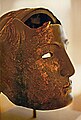
Masked helmet in Limesmuseum Aalen


- Parts of the former fort are still preserved or reconstructed in Großkrotzenburg . The local museum shows the history of the city with finds and information about Roman times. Among other things, about the Roman brickworks operated here , whose products were found along the Main and Rhine.
- Seligenstadt the city on the Main was already very important in the Carolingian era . It was founded by Einhard , the biographer of Charlemagne . The most important building in Seligenstadt is the Einhard Basilica of St. Marcellinus and Petrus . Although the building has changed a lot over the centuries, it is still one of the most impressive basilicas with Carolingian structures north of the Alps. The Benedictine monastery complex to the south, closed in 1803, with baroque wing buildings and large courtyards and gardens has been fully restored. The city has a large number of historic buildings and half-timbered houses from the 17th and 18th centuries. Most of these two to three-story half-timbered houses are on the market square and in the surrounding streets. In the district of Klein-Welzheim, near the historic monastery fish ponds, there is a moated castle in the style of a medieval castle, but with baroque additions, which the Seligenstadt abbot designed as a summer residence in 1707.
- The city of Aschaffenburg offers a variety of attractions. Pompejanum and Johannisburg Castle are right on the bike path (see also Aschaffenburg # Culture and Sights ).
- In Obernburg am Main there is a Roman museum , which mainly contains finds from the Obernburg fort and the associated settlement. There is a replica of a giant Jupiter column on the museum grounds . In the city are the remains of the city fortifications, the upper gate, the Almosenturm and the round tower, the town hall and the Anna chapel and the baroque church in Eisenbach.
- In Wörth am Main there is the shipping and shipbuilding museum , which documents the historical development of inland shipping and shipbuilding on the Main, as well as the medieval old town. In addition to many half-timbered houses, there is the old town hall, the upper gate of the former land-side city entrance, the fir tower from the 15th century, which forms the northern end of the city wall on the river side. This has meanwhile been expanded as a flood protection wall at the same time.
- The old town of Miltenberg is about a kilometer off the Limes cycle path, but is worth a detour on the Main cycle path. In the historic old town there are among others the following sights:
- The Mildenburg lies above the old town.
- The Museum Stadt Miltenberg shows the historical and cultural development of the city and received the Bavarian Museum Prize in 1999 for its conception and presentation .
- The "Schnatterloch" is located on the historic market square. The Schnatterlochturm offers a passage from the market square directly into the forest. Under this passage is the actual Schnatterloch: This is a hole that opens into a drainage channel that leads to the market square. The name Schnatter is derived from the old word Snade , which was used to designate a border, because the rainwater ditch was originally the city limit.
- The Hotel Zum Riesen is one of the oldest or possibly the oldest inns in Germany.
- The old town hall dates from 1379.
- The Würzburg and Mainz gates are well preserved as city gates .
- The Laurentius Chapel with the adjoining Laurentius Cemetery (approx. 14th century) is located in the immediate vicinity of the Mainzer Tor .
- Amorbach developed from the former Benedictine monastery Amorbach , whose baroque monastery church with rococo stucco still dominates the image of the old town today. Not far from the monastery church is the Fürstlich-Leiningen Palace , which is still the family seat of the Princes of Leiningen today.
- Walldürn is located in the so-called Madonnenländchen and is primarily known as a place of pilgrimage, in the center of which is the pilgrimage basilica of St. Georg . The pilgrimage developed around the blood miracle of Walldürn , which is said to have occurred around 1330. There are also numerous historical buildings in the old town area, including the town hall from 1448.
- In Osterburken is located archaeological excavation zone around the former fort Osterburken . The cohort fort, along with the annex fort, bathing buildings and consecration area, is one of the richest Roman provincial sites in southwest Germany. The fort bath was integrated into the Römermuseum Osterburken after its exposure . There is also a copy of the most important archaeological find from Osterburken, a Mithras relief depicting the mythological killing of the primal animal by the god Mithras.
- In Jagsthausen standing Jagsthausen , even Götzenburg called. It goes back to the historic castle from the 14th and 15th centuries, where Götz von Berlichingen spent a few years of his childhood and which later became known primarily through Goethe's drama Götz von Berlichingen . The Friedrich Krapf Museum, housed in the Old Town Hall, houses more than 2000 Roman finds. Another important collection of antiquities on local history is in the castle museum in the Götzenburg. A supposedly real Iron Hand by Götz von Berlichingen is also exhibited there. The archaeological monument and open-air museum Römerbad Jagsthausen is located in the center of the village .
- The medieval market square is the heart of the Öhringen . There is the former Hohenlohe castle , together with the collegiate church the landmark of the city. The renaissance castle was the residence of the Counts and Princes of Hohenlohe. A few towers have been preserved on the former city wall.
- There were two Roman forts in Welzheim . For the 800th anniversary of the city in 1980, the west gate with a section of the defensive wall at the smaller east fort was scientifically reconstructed and supplemented by an archaeological park in 1993 ; the remains of the west fort were built over in the 20th century.
- The main attraction of the town of Lorch in the Remstal is the Lorch Abbey on the Klosterberg. In the chapter house of the monastery, a 100 m² round picture shows the history of the Staufer family.
-
Schwäbisch Gmünd has a well-preserved old town with a lot of historical buildings. In addition to the secular buildings, the churches and monasteries in particular shape the image of the old town.
- One of the city's landmarks is the Heilig-Kreuz-Münster , which was designed in the 14th century in the Gothic style and is the largest hall church in southern Germany.
- Another landmark of the city is the Romanesque St. John's Church, first mentioned in 1225, with its Romanesque bell tower, one of the first representatives of this type of construction.
- The former Franciscan monastery is used as a Catholic administrative and community center. The associated monastery church, today's Catholic parish church of St. Franziskus , is known for its carpenter high altar and tub maker frescos.
- The pilgrimage complex St. Salvator am Nepperstein is located above the old town . It consists of the Way of the Cross, chapels and church and was built from 1616.
- In addition to the church buildings, many secular buildings also shape the old town. The historical market square is of particular interest. One of the oldest houses on the market square is the Grät . This large half-timbered house has already served as a town hall, mayor's seat and a department store.
- At the other end of the market square is the former Hospital of the Holy Spirit with its large medieval office building, which is now used as the city library.
- The historical center of Aalen is the market square. There you will find the historic town hall, today the paleontological museum and the old town hall . Until 1851, the Hotel Krone-Post was located in the building, which was also the Thurn-und-Taxis-Post station . The city center is dominated by the Protestant town church St. Nicholas in the heart of the pedestrian zone. The church, built in its present form from 1765 to 1767, is the only larger late baroque building in Aalen. There are two museums in the Aalen city center.
- The Limes Museum stands at the point where the largest Roman equestrian fort north of the Alps was. It shows numerous finds from the time of the Roman occupation. The ruins of the Reiterkastell next to the museum can be visited.
- In the geological - paleontological museum (called Urweltmuseum ) in the historic town hall, more than 1500 fossils from the Swabian Alb such as ammonites , ichthyosaurs and silicified corals can be seen.
Swabian Alb, Franconian Alb and Danube

Ellingen residence
Pleinfelder Tor in Ellingen

Town hall in Ellingen
Einhorn pharmacy in Weissenburg

Fort reconstruction in Weißenburg

Ellingertor in Weissenburg

Weltenburg Abbey
Danube breakthrough
Liberation Hall over the Danube

Danube author Kelheim

Porta Praetoria in Regensburg

Bay window of the Regensburg Reichstag hall

St. Peter's Cathedral, Regensburg

St. Emmeram Monastery, Regensburg


.jpg)
.jpg)
.JPG)


- In Hüttlingen an der Kocher there are replicas of various stages of the Limes in palisade and wall construction.
- The Römerpark Ruffenhofen is an archaeological park . On a total area of around 40 hectares, the Ruffenhofen fort and large parts of the associated civilian settlement have been preserved underground and unsupervised. On October 13, 2012, a dedicated museum, the Limeseum , was opened. The exhibition primarily provides information about the three world heritage components: the Limes line, the fort and the civilian settlement of Ruffenhofen.
- In the city of Gunzenhausen , part of the battlements and three towers have been preserved from the medieval city fortifications. The historic market square is characterized by important baroque buildings that either came into being during the reign of the “ Wild Margrave ” or were given their current appearance. A section of the Limes between two former watchtowers was conserved and partially reconstructed by the Bavarian State Office for Monument Preservation.
- The townscape of Ellingen is largely shaped by the work of the Teutonic Order and shows the stylistic unity of a small baroque residence . In the Ellingen Baroque circular path, important buildings from the past are brought together, including the Ellingen Residence and the associated castle park , the town hall , the Pleinfelder Tor , the former Franciscan monastery , the Catholic parish church of St. George , the Maximilian Church , the orangeries in the Hofgarten, the Heiligenbrücke and the Johannes Bridge.
- In Weißenburg in Bavaria the Roman thermal baths , an old Roman village complex and the remains of the Roman fort Biriciana are reminiscent of Roman times. The thermal baths were discovered in 1977 and have been expanded into a museum since 1983. In the Roman fort, the north gate has been fully reconstructed on the basis of scientific excavations and the Roman Museum in Weißenburg shows important archaeological finds , the center of which is the Roman treasure of Weißenburg , which was found in 1979 . It consists of 114 top-quality antique handicrafts , a large part of which are metal artifacts. Further finds from the former Roman fort Biriciana and finds from almost all epochs from the Stone Age to the late Middle Ages round off the exhibition.
- The well-preserved Renaissance fortress of Wülzburg on a nearby mountain above the city has been owned by Weißenburg since 1882 . It was originally a Benedictine monastery that was converted into a fortress in 1588. Since 1968 it has had the status of a National Monument.
- In the old town are:
- The Ellinger Tor , which was the last of three gates to be preserved in the city fortifications.
- The cityscape is characterized by late medieval half-timbered houses and baroque town houses, including the Old Latin School , the Scheibleinsturm , the former Wildbad , the Old District Court , the Blue House , the Lebküchnerhaus , the Rosenbad , the Fünfeckturm , the New and the Old Town Hall and Rosenstrasse .
- Today's Gothic , Protestant parish church of St. Andreas was consecrated in 1327, expanded by 1400, raised in 1891 and converted to its original Gothic shape in 1958. The hall choir of the listed church is relatively high and is considered an outstanding work of the southern German late Gothic .
- Kipfenberg is a market town in the Altmühltal . The place is dominated by the medieval castle Kipfenberg . The Roman and Bavarian Museum Burg Kipfenberg with the integrated Limes InfoPoint is housed in one of their farm buildings.
- Weltenburg Abbey is located in the Weltenburg district of Kelheim . The Benedictine abbey , located directly on the Danube, is best known for its popular monastery brewery and the nearby Danube breakthrough , which can be crossed by excursion boat from here. As early as 45 AD, Weltenburg on the south bank of the Danube was the starting point of a Roman border and military road that followed the Danube upstream to the Hüfingen fort near Donaueschingen. This southern Danube road has long been one of the two most important east-west connections north of the Alps . The monastery, founded around the year 617 by the Iro - Scottish monks Eustachius and Agilus from Luxeuil according to the rules of Saint Columban , is considered the oldest monastery in Bavaria . The brewery, which has existed since 1050, is probably the oldest existing monastery brewery in the world.
-
Kelheim is located in the triangle where the Danube and Altmühl meet, below the Michelsberg , on which the Liberation Hall , built in the 19th century, stands. There are also:
- the historic old town with parts of the city fortifications from the 13th and 14th centuries with the Donautor, Mittertor and Altmühltor;
- the city pharmacy with bay window and Hebrew tombstone from 1249;
- Ludwigsplatz with the Old Town Hall, built in 1598, the former town clerk's office;
- the New Town Hall from 1912 in a redesigned Renaissance building with a curved gable;
- the old canal port, which was part of the historic Ludwig-Danube-Main Canal , which opened in 1846 ;
- the grinding tower (1474–1486), also incorrectly called the “Roman tower”, since ashlars were used in the construction, which are similar to ancient stones, but come from the keep of the Wittelsbacher castle, which was otherwise razed.
- Today's bishopric and district capital of the Upper Palatinate , Regensburg is located on the site of the Roman legionary camp founded by Emperor Marc Aurel in 179 AD . The Porta praetoria in the former bishop's court bears witness to this time. Regensburg, as one of the oldest German cities, looks back on an eventful history. Probably the best-known historical function of the formerly free imperial city is the Perpetual Diet of the Holy Roman Empire of the German Nation , which met in the Imperial Hall of the Regensburg City Hall from 1663 to 1803 , which dissolved itself with the Imperial Deputation in 1803 as a result of the wars with revolutionary France . The list of sights in Regensburg with the old town ensemble "Altstadt mit Stadtamhof", which has been part of the cultural heritage since 2006, is long. Here is a small excerpt:
- The Stone Bridge , probably built between 1135 and 1146, was the only Danube bridge in Regensburg for more than 800 years.
- The Regensburg Cathedral is the most striking building in the old town that dominates the old town. The also Cathedral of St. Peter Church called is the cathedral of the Diocese of Regensburg and the main work of Gothic architecture in southern Germany.
- In the west of the Neupfarrplatz was the former merchant town, here are numerous former patrician palaces. In the middle of the 13th century, the Regensburg merchant families competed for the greatest reputation by building family towers. They had amassed great fortunes through long-distance trade as far as Paris, Venice and Kiev.
- The Old Town Hall with the Reichstag Museum , formerly the seat of the “Perpetual Reichstag”, is located on Rathausplatz .
- The important St. Emmeram monastery church is located on Emmeramsplatz . The monastery itself was transformed into today's St. Emmeram Castle, which contains several museums. From 1792 to 1812 the palace housed the court of the Princes of Thurn and Taxis , who represented the emperor as principal commissioner at the “Perpetual Reichstag”. The castle is inhabited by members of the von Thurn und Taxis family. The state rooms of the palace with tapestries from the Brussels period and interior furnishings from the Palais Thurn und Taxis in Frankfurt am Main can be visited .

literature
- German Limes cycle path. Part 1: From Bad Hönningen to Miltenberg. Bikeline bike tour book, 1: 75,000. 1st edition. Verlag Esterbauer, 2003, ISBN 3-85000-088-5 .
- German Limes Cycle Path Part 2: From Miltenberg to Regensburg. Bikeline bike tour book, 1: 75,000. 1st edition. Verlag Esterbauer, 2000, ISBN 3-85000-046-X .
- Limes cycle path on the UNESCO World Heritage Site Upper German-Rhaetian Limes from the Rhine to the Danube; Bikeline bike tour book , 1: 75,000. 1st edition. Verlag Esterbauer, 2015, ISBN 978-3-85000-655-2 .
- Walter E. Keller (ed.): German Limes Road from the Rhine to the Main. Verlag WE Keller, 1999, ISBN 3-924828-99-7 .
- Walter E. Keller (ed.): German Limes Road from the Main to the Danube. 2nd Edition. Verlag WE Keller, 2000, ISBN 3-934145-03-5 .
Web links
- Route on Openstreetmap
- German Limes Cycle Route on radreise-wiki.de
- German Limes Cycle Path on limesstrasse.de.Retrieved June 5, 2016
- Detailed description of the Limes cycle path with numerous pictures, elevation profiles and a detailed route description
Individual evidence
- ↑ Bike Tour Wiki , accessed December 2012.
- ↑ German Limes Cycle Path (on adfc-tourenportal.de) ( Memento from March 26, 2018 in the Internet Archive )
- ↑ Schnatterloch Miltenberg on Frankenwiki Accessed in Nov. 2012.
Coordinates: 50 ° 30 ′ 13 ″ N , 7 ° 19 ′ 6 ″ E