Wesel
| coat of arms | Germany map | |
|---|---|---|
|
Coordinates: 51 ° 40 ′ N , 6 ° 37 ′ E |
|
| Basic data | ||
| State : | North Rhine-Westphalia | |
| Administrative region : | Dusseldorf | |
| Circle : | Wesel | |
| Height : | 24 m above sea level NHN | |
| Area : | 122.56 km 2 | |
| Residents: | 60,230 (Dec. 31, 2019) | |
| Population density : | 491 inhabitants per km 2 | |
| Postcodes : | 46483, 46485, 46487 | |
| Primaries : | 0281, 02803 , 02859 | |
| License plate : | WES, DIN, MO | |
| Community key : | 05 1 70 048 | |
| LOCODE : | DE WES | |
| City structure: | 5 districts | |
City administration address : |
Klever-Tor-Platz 1 46483 Wesel |
|
| Website : | ||
| Mayoress : | Ulrike Westkamp ( SPD ) | |
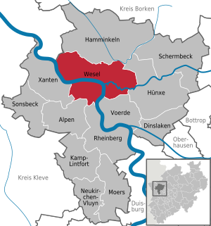
| Location of the city of Wesel in the Wesel district | ||
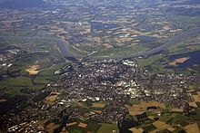
The Hanseatic city of Wesel is located on the Lower Rhine and is the county seat of the Wesel district . It belongs to the administrative district of Düsseldorf of the state of North Rhine-Westphalia and has the status of a large district city with around 60,000 inhabitants . Wesel lies on the rivers Rhine and Lippe and has several large cities in the wider area. In Wesel the Lippe flows into the Rhine.
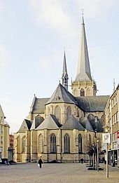
In the late Middle Ages Wesel developed into an important trading town and in 1407 it was accepted into the Hanseatic League . The historic town hall dates from the Hanseatic era, the facade of which was destroyed in the Second World War and was reconstructed by 2011. The Protestant Willibrordi Cathedral also has the appearance of the 16th century again after various construction phases.
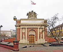
Under Prussian rule, the expansion of the city into a fortress of Wesel began in 1681 . The city remained dominated by the military until the 20th century and, due to its strategic importance, was severely damaged in the Second World War. Several buildings have been preserved from the fortress, including the Wesel Citadel and the Berlin Gate . The citadel is used today as a cultural center with various facilities. The former glacis of the fortress Wesel was converted into green areas.
Wesel has been the district town since 1842. With the regional reforms of 1969 and 1975, the urban area has expanded significantly. Since then, it has encompassed a larger rural area, which is characterized by the Rhine, Lippe, the dredged Auesee and larger forest areas such as the Diersfordter Wald. The city is considered to be one of the most bicycle-friendly in Germany, and the nearby A3 and several federal highways are important connections for car traffic .
geography
Position and extent
Wesel is located on the Lower Rhine and is surrounded by various landscape and cultural areas. On the one hand, the city is located on the outskirts of the Ruhr area , is a member of the Ruhr Regional Association and around 25 kilometers as the crow flies from the city centers of the major cities of Duisburg and Oberhausen to the south . Düsseldorf is around 50 kilometers, Cologne around 85 kilometers south. In the north and west across the Rhine, on the other hand, lies the comparatively sparsely populated landscape of the lower Lower Rhine and to the north the border with the Netherlands is around 25 kilometers as the crow flies. To the east and north-east of the city is the Hohe Mark-Westmünsterland Nature Park , which is also the border with the Westphalia region . The river Lippe flows into the city of Wesel and flows into the Rhine, as does the Issel .
The urban area covers an area of 122.56 square kilometers, making Wesel the second largest city in the district after Hamminkeln . The maximum north-south extension is 12.0 and the maximum east-west extension 17.3 kilometers. Since the regional reform, Wesel includes the Büderich district in addition to its core area on the right bank of the Rhine, as well as an area on the left bank of the Rhine with an area of 24 square kilometers. This makes Wesel the city furthest down the Rhine, encompassing areas on both sides of the river. The population density is almost 500 inhabitants per square kilometer, but it is distributed very differently. The most densely populated district of Wesel has almost 1,500 inhabitants per square kilometer, while the Bislich district only has around 70 inhabitants per square kilometer.
In the northwest, Wesel, with its district of Bislich, borders the area of the city of Rees , which is also located on the Rhine and is the only neighboring municipality that does not belong to the Wesel district but to the Kleve district . To the north, the urban area borders on the city of Hamminkeln and to the north and east on the municipality of Hünxe . They are each comparatively sparsely populated communities with fewer than 200 inhabitants per square kilometer. In the south, the Wesel-Datteln Canal forms the border with the city of Voerde . In this direction Wesel is connected to the agglomeration of the Ruhr area. In the southwest there is a border with the city of Rheinberg on the left bank of the Rhine . There is a land border to the west of the city of Xanten on the left bank of the Rhine (Büderich district) and a border marked by the Rhine (Bislich district on the right bank of the Rhine). The total length of the city limits is 61.8 kilometers.
Land use
In 2016, almost half of the urban area was taken up by agricultural land, making it by far the largest share of the various forms of land use. The proportion of building and open space in the urban area almost corresponds to the national average, whereas operational, recreational and traffic areas are each slightly above the national average. Overall, the total share of settlement and traffic areas in the urban area is 24.6% and thus slightly above the national average of 22.9%. It is the sum of the previously mentioned types of area, which is calculated slightly differently. The proportion of forest area in 2016 was significantly lower than the national average. At 14.6%, however, the proportion of forests was only slightly below the average for the Düsseldorf administrative district (15.6%). At the beginning of 2016, Wesel was the one with the largest share of water surface of all municipalities in the state of North Rhine-Westphalia. This was 13.3%, compared to only 1.9% in the national average. In addition to the several hundred meters wide Rhine and the rivers Lippe and Issel, there are also several quarry ponds, including the Auesee and the Diersfordter Waldsee . With the exception of the Auesee, which is very close to the city, all of the larger quarry ponds are located in the Bislich district and, to a lesser extent, in the Büderich district . The neighboring cities of Rees (12.4%) and Xanten (11.4%) also had more than 10% water areas in 2016.
City structure
| Surname | Area in km² | Population (December 31, 2019) |
Inhabitants per km² | coat of arms |
|---|---|---|---|---|
| Wesel | 26.08 | 38,300 | 1,469 |
|
| Hallways | 9.15 | 4,792 | 524 |
|
| Obrighoven-Lackhausen | 26.79 | 11,026 | 412 |
|
| Up to now | 36.53 | 2,560 | 70 |
|
| Buderich | 24.00 | 5,823 | 243 |
|
| total | 122.55 | 62.501 | 510 |
Spatially, the city is divided into the following five districts , which in turn consist of further districts:
- Bislich : Bergerfurth , Bislich and Diersfordt
- Büderich : Büderich, Ginderich and Werrich / Perrich
- Corridors : Corridors
- Obrighoven-Lackhausen : Lackhausen , Obrighoven and Wittenberg
- Wesel: Altstadt, Blumenkamp , Feldmark , Fusternberg and Schepersfeld
For data on the individual districts, see the list of districts of Wesel .
The subdivision into urban and districts serves primarily statistical purposes, but reflects certain historical circumstances. With the exception of Blumenkamp in the north and Lippedorf in the south, the Wesel district includes areas that were part of the city in the Middle Ages. The development of the Feldmark, Fusternberg and Schepersfelds into urban districts did not begin until around 1890. The districts of Obrighoven-Lackhausen and Flüren were each incorporated in 1969, but their historical development was already closely linked to Wesel and have a population density close to the average entire urban area. In contrast, Bislich and Büderich were only incorporated into the municipality in 1975, have a lower population density and more rural structures.
history
Antiquity
Finds in the gravel pits near Bislich indicate a settlement in the Wesel area as early as the Bronze and Iron Ages . However, due to the frequent shifts in the river bed of the Rhine and the Lippe and the associated flooding, the early history of Wesel can only be reconstructed incompletely. Presumably a guard post was set up in the area on the right bank of the Rhine, later Wesel, when the Roman Empire expanded in the first century BC. BC to the Lower Rhine and the military area of Vetera (also Vetera Castra) was founded in the left-bank area of the later Xanten ; however, this has not yet been proven.
middle Ages

The first demonstrable settlement in today's Wesel urban area was the Lippeham base after the migration of peoples in the area where the Lippe flows into the Rhine. From here, Emperor Charlemagne undertook several campaigns against Saxons and Danes . The further development of this settlement is largely unknown, but it was probably inundated by the Rhine and Lippe floods and subsequently abandoned.
The origin of today's city is believed to be a Franconian manor, which was located in the area of today's grain market. At the beginning of the 8th century, a copy of a document in the Echternach monastery first mentioned the name " Wesele ". During excavations in the ruins of Willibrordi Cathedral after the Second World War , the existence of a half-timbered church in the 8th century has been proven. In a document dated May 1, 1065, King Henry IV confirmed the return of the church and the property of the " villa Wisele " to the Echternach monastery .
At the beginning of the 12th century, Wesel, which in the meantime had developed into a trading center thanks to its location on the Rhine and Lippe, fell as a dowry to the Counts of Kleve . In September 1241 Wesel was granted city rights by the young count Dietrich primogenitus from Kleve and received them even before Kleve , which was elevated to the status of city in 1242. As a result, the citizens of Wesel received a number of privileges , including free inheritance and duty-free at all sovereign customs posts. Up to 1603 the sovereigns granted a total of 122 privileges for the townspeople, making Wesel the most privileged town in the state of Kleve.
While trade in the 13th century was limited to the buying and selling of food and handicrafts, there was an economic boom in the 14th century, when more imported raw materials were processed and finished goods were exported. In particular, cloth production contributed to the city's prosperity. In 1407 she became a member of the Hanseatic League . As a result, Wesel became the most important stacking and transshipment point to Cologne for goods imported from the Netherlands and Westphalia. Already at the Lübeck Hanseatic Day in 1447 Wesel was considered one of the five suburbs of the Cologne Hanseviertel.
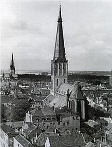
The economic boom is particularly evident in the buildings of this time, such as the Wesel town hall , which was built from 1456 to 1457 and is one of the most famous Rhenish secular buildings of the Gothic style . After being destroyed in the war, the facade of the Great Market was reconstructed in 2011 . From 1498 to 1540, the Willibrordi Cathedral was expanded as a late Gothic basilica to five naves . The tower, built in 1478, was taken over from the three-aisled previous building from 1424 to 1480.
The Mathena suburb , which grew on the damp meadow area ( Matena ) east of the old town, was walled in 1434 . In 1440 construction began on the late Gothic parish church of St. Nicholas and Antonius , which was completed around 1500.
Since 1342 there has also been a grammar school that still exists today , then called a Latin school . Since 1984 it has been named after one of his most famous high school graduates, Konrad-Duden-Gymnasium .
Reformation and modern times

Unlike in many cities in the area, the Reformation had an early influence on Wesel. At Easter 1540, the Lord's Supper was distributed to the ducal judge, most of the council members and 1,500 citizens, according to the wishes of the citizens "in both forms". From that day on, Wesel was considered a city of Protestantism , which attracted many religious refugees, especially from the Netherlands. In 1568 the Dutch refugee communities organized themselves in the Wesel Convention , which exerted considerable influence on the constitution of the Dutch and German Protestant churches. In 1578 the city received two magnificent goblets known as the Geusenbecher as recognition from the religious refugees . The honorary name "Vesalia hospitalis" (about hospitable Wesel ) is engraved on them.
In 1609 Wesel and the Duchy of Kleve fell to the Electors of Brandenburg . During the Eighty Years' War Wesel was initially occupied by the Spaniards until the city was conquered by Dutch troops in 1629 . During the Dutch War , Wesel was conquered by French troops in 1672, who occupied and plundered the city until 1680.
Under Elector Friedrich Wilhelm, Wesel was eventually expanded into a fortress and a system of moats and bastions was built around the city. The urban expansion was limited to the old town and Mathena suburb, a development beyond this limitation was prohibited by the rayon laws. Of the former thirteen city gates from the Hanseatic era, only four have been preserved. A number of fortress structures date from the 16th to 19th centuries, on which Prussia and France primarily worked.
On August 12, 1730, one week after his failed attempt to escape, Crown Prince Friedrich of Prussia , who later became Frederick the Great, met his father, the soldier king, at Wesel Fortress , who wanted to kill him as a result of a violent exchange of words. Only the intervention of the commandant, Major General von der Mosel , prevented a tragedy.
19th century
In December 1805 Prussia ceded Wesel to Napoléon Bonaparte . In January 1808, the city was incorporated into the French Empire as a bridgehead on the right bank of the Rhine and was assigned to the Arrondissement de Clèves in the Département de la Roer as the 9th canton . On September 16, 1809, the eleven Schill officers were fusiled here. In 1813/1814, 148 students from the Ghent seminary were imprisoned in the citadel by the French occupying forces , 35 of whom were killed.
Prussia regained its former possession in 1815. Wesel was then expanded into a garrison town, including the Wesel Citadel , in which infantry, artillery and sometimes cavalry and pioneers were stationed until the First World War . Due to this role as a fortress city, Wesel could not compete economically with the cities of the Ruhr area despite its favorable location and infrastructure. Even after the city was decongested in 1886, no economic connection to the Ruhr area could be found. The green belt that surrounds the city center was created on the former ramparts of the fortress ( glacis systems ).
On April 23, 1816, Wesel became a district town of the newly formed Rees district in the later Rhine province as part of the Prussian administrative organization . The seat of the district was relocated from Rees to Wesel on May 20, 1842 , whereby the district name was retained ("District Rees, seat in Wesel"). The then district administrator wanted a decent education for his son and there was no boys' high school in Rees.
In 1886 it was decided to de-strengthen Wesel and the process of razing it was initiated. In 1889 the city of Wesel acquired large parts of the fortress grounds. In the development plan of the Cologne builder Josef Stübben , the city gained 62 hectares of building land, which more than doubled the civil usable area. But the existing barracks also gained building land. In the following years the three city gates Brüner Tor, Rheintor and Klever Tor were removed and only the Berliner Tor was retained. The Jöckern house was also demolished. In the area of the former ramparts, ring roads were built around the city. However, the citadel and esplanade in the south were preserved.
Time of world wars
During the First World War Wesel became a military assembly point from which troops moved to the western front . With the demilitarization of the Rhineland as a result of the Versailles Treaty , Wesel was abandoned as a military base after the war.
Parts of the urban area were occupied as part of the Allied occupation of the Rhineland . This affected the bridgeheads and the port area. The occupation was lifted again in October 1924 - before the first zone of the Allied occupation of the Rhineland in 1926 was cleared .
With the start of the rearmament of the Wehrmacht in the Nazi era troops were stationed in Wesel again.
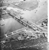
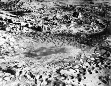
During the Second World War, Wesel was targeted by the Allies , particularly because of its strategic location . From February 7, 1945 to February 22, 1945 there was the battle in the Reichswald in the Kleve area . Advancing British troops believed at the beginning of the battle that they would be able to advance to the Xanten-Geldern line within three to four days; they were surprised at how strong and bitter the resistance was. Only after this battle could the Allies build a bridgehead over the Rhine near Wesel and start conquering the Ruhr area (see Ruhrkessel ). In the course of this advance Wesel was almost completely destroyed by Allied bombing and shell fire on February 16, 17 and 19, 1945. The Rhine and Lippe bridges were blown up by members of the Wehrmacht , including the 1950 m long railway bridge on March 10 , which at that time was the last bridge over the Rhine still in German hands . On March 23, Wesel was bombed again in preparation for Operation Plunder , and over 3,000 guns caught fire. 97 percent of the urban area was destroyed, the remnants were eventually taken by Allied troops.
reconstruction
In mid-1946, the scheduled clearing of rubble and the subsequent reconstruction began, which was carried out with the help of the newly founded emergency company "Wesel helps itself". The construction of public buildings was also pushed ahead, with particular emphasis on the reconstruction of the Willibrordi Cathedral by the Willibrordi Dombauverein.
dialect
Weseler Platt and the dialects of the districts, as well as the dialects of the neighboring communities, are based on the Lower Franconian languages that were spoken at the time of the early medieval expansion of the Franks on the Lower Rhine. The dialects between Emmerich and Duisburg / Mülheim-Ruhr are assigned to the North Lower Franconian spoken north of the Uerdinger line (also called Kleverländisch ). It is characterized by the use of “ek” for the personal pronoun “I”. South of this line, in South Lower Franconian (also called East Limburgish ), “isch” or “esch” is spoken instead of “I”. The Benrath line (maake-maache distinction) runs even further south, dividing the southern Lower Franconian from the Middle Franconian (with the Ripuarian dialects , including Kölsch ). The unit plural line runs east of Wesel in the Bocholt area towards Westphalian . Although Weseler Platt is cultivated in clubs and dialect circles, the number of dialect speakers is constantly falling. Younger people are increasingly using a colloquial language called Lower Rhine German - called Regiolekt by scientists .
Territorial reform
On July 1, 1969, as part of the first municipal reorganization program, the previously independent municipalities of Flüren ( Ringenberg Office ) and Obrighoven-Lackhausen were merged with the city of Wesel.
On January 1, 1975, as part of the second reorganization program, the previously independent communities Bislich and Diersfordt and the Blumenkamp district of the Hamminkeln community (all from the former Ringenberg district in the Rees district ), the Büderich with Ginderich in the Moers district , the Lippedorf district the municipality of Voerde in the district of Dinslaken and a small area of the municipality of Hünxe of the former office of Gahlen in the district of Dinslaken incorporated into the city of Wesel.
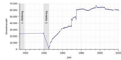
As a result, the urban area grew from 19.63 km² on June 30, 1969 to 122.46 km² on January 1, 1975. The population rose from 36,046 to 60,488.
On May 8, 1974, the President of the North Rhine-Westphalia state parliament announced the result of the vote, according to which Wesel was designated as the district town of the new Wesel district from January 1, 1975 as part of the municipal reorganization .
Population development
|
|
|
swell
- 1914-30. June 1999: City Archives of the Hanseatic City of Wesel (main and secondary residence)
- December 31, 1999–31. December 2004: Nicole Ruthert, isolated statistical office of the Hanseatic City of Wesel (main and secondary residence)
- from 2005: State Office for Data Processing and Statistics (only main residence)
politics
City council
The 50 seats in the city council were distributed among the individual parties according to the results of the local elections on May 25, 2014 (number of seats in 2009 for comparison):
| Party / list | Election 2009 | Election 2014 |
| Christian Democratic Union of Germany (CDU) | 20th | 21st |
| Social Democratic Party of Germany (SPD) | 19th | 19th |
| Alliance 90 / The Greens (GREENS) | 4th | 4th |
| Free Democratic Party (FDP) | 4th | 2 |
| The Left (DIE LINKE) | 2 | 2 |
| WWW - the young alternative (WWW) | n / A | 1 |
| Pirate party | n / A | 1 |
Four members of the CDU parliamentary group left this in September 2015 and formed their own parliamentary group WfW (We for Wesel).
After the election, the Pirates and WWW formed a joint parliamentary group that was dissolved on December 1, 2016 after the WWW member joined the SPD. This made the member of the Pirate Party non-attached again.
After these resignations and the formation of new parliamentary groups, the 50 seats in the city council are divided between the following groups :
| fraction | Election 2014 | current |
| Social Democratic Party of Germany (SPD) | 19th | 20th |
| Christian Democratic Union of Germany (CDU) | 21st | 17th |
| Alliance 90 / The Greens (GREENS) | 4th | 4th |
| We for Wesel (WfW) | 0 | 4th |
| Free Democratic Party (FDP) | 2 | 2 |
| The Left (DIE LINKE) | 2 | 2 |
| Non-attached | 2 | 1 |
In addition, the mayor is a member of the city council.
mayor
The first female mayor in the history of the city of Wesel is Ulrike Westkamp ( SPD ). In the local elections in 2009 she was elected to this office with 52.5% of the valid votes; In 2014 she was confirmed in office with 52.3%.
|
The mayors of the city of Wesel 1808–1945:
|
The mayors of the city of Wesel since 1945:
|
Coat of arms, flag, seal and logo
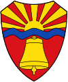
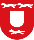
Blazon : "The coat of arms of the city of Wesel shows a silver heart shield in a red field , which is accompanied by three silver weasels jumping to the left ."
Meaning: The heart shield refers to the rider's seal of the Duke of Kleve . The weasel has been handed down as a coat of arms of the city since the 13th century and translates the name of the city figuratively. In its current form, the coat of arms is used after a change in the main statute in 1984.
Flag: The city of Wesel uses the colors red-white-red (horizontal stripes in a ratio of 1: 3: 1). In the middle of the white line is the city's coat of arms.
Seal: The city of Wesel has an official seal with the city coat of arms.
City partnerships, sponsorships and friendships
The city of Wesel maintains several city partnerships, mostly built over years through private, school and club contacts :
- In 1952 a partnership was established with Hagerstown in Maryland / USA , one of the oldest German-American town twinning ever.
- 1972 followed Felixstowe in the county of Suffolk in Great Britain .
- In 1990 the city of Wesel became a sister after reunification with Salzwedel in Saxony-Anhalt .
- The most recent partnership was concluded in 2002 with the city of Kętrzyn (formerly Rastenburg in East Prussia ) in Poland .
In addition, Wesel is the sponsor city of the supply ship “Rhein” of the German Navy and the telecommunications battalion 284 of the German Armed Forces stationed in Wesel (since 2003) and, since 2014, an Airbus 320 of Lufthansa .
There have been contacts with Lisieux ( France ) for many years through a lively student exchange.
Culture, religion and sights

Theater and concerts
The Niederrheinhalle on the Fusternberg is the venue for large events such as trade fairs and conferences. In the municipal stage area Wesel find theater guest performances , symphony - and chamber concerts take place. The Wesel Cathedral concerts in the Willibrordi Cathedral and the concerts in the auditorium of the Wesel Music and Art School in the Citadel Complex complete the offer. On Wilhelmstrasse between the train station and Berliner Tor, the Scala Kulturspielhaus has established itself in a former cinema as a venue for cabaret. There is also a lively artistic offering in the outskirts. These include the concerts in both Bislicher churches of the Pro Musica association and the cultural series Kleinod of the Evangelical parish of Büderich as well as the culture salon in the Waldhotel Tannenhäuschen.
Recurring events

Once a year since 2008 there has been an open-air festival called EselRock with free entry in Wesel , organized by a volunteer team in cooperation with the city of Wesel. According to the organizers, over ten thousand visitors were counted in 2010 and 2011.
The Wesel Culture Night has been held every September since 2002 . This includes various program items throughout the city center and focuses on the Citadel cultural center. The most important city festivals include the PPP days in summer, the main events of which are a fair and large fireworks on the Rhine. The historic Hanseatic Festival, which takes place every year in October, takes up Wesel's history as a Hanseatic city and includes a medieval market. The two city festivals mentioned are events lasting several days. In the run-up to Christmas, there is an Advent market on the Great Market in front of the cathedral and a Nicholas market around the Berliner Tor .
The Erna Suhrborg Art Prize was awarded for the first time in 2017. Hans Dieter Suhrborg, son of Erna Suhrborg , and his wife Gabriele (also an artist) came up with the idea of the prize to promote women artists without academic training. The city of Wesel gladly accepted this suggestion and launched a competition. The prize is to be awarded every three years.
Donkey from Wesel
Going back to the famous Echoruf “What is the name of the mayor of Wesel? Donkey. ”, Which spread in the 19th century, the donkey has become the symbol of the city. It has multiple uses in local art and culture. On the one hand, he is the namesake of events such as the EselRock Festival and the donkey medals awarded by carnivalists . When it comes to the use of art, there are primarily several hundred life-size painted donkey figures made of plastic that have been made since 2007 and can sometimes be found in public places throughout the city.
City library, city archive
The Wesel City Library is located on two floors in the city hall complex. The children's and youth area is on the first floor and adult literature and specialist literature on different areas is on the second floor. The Wesel City Library has around 100,000 media units in total. It is located in the same building as the local community college.
The Wesel city archive in the citadel complex offers an extensive archive inventory (documents and documents since 1241). A restoration workshop is attached to it.
Museums
The Municipal Museum has three departments:
- the gallery in the "Centrum" with changing exhibitions and the permanent exhibition "Weseler Silber" and "Oath"
- in the citadel complex above
- the Schill Casemate Department and
- the fortress history department.
The gallery regularly offers four to five changing exhibitions with works by predominantly regional artists and (art) historical themes. The Niederrheinischer Kunstverein Wesel e. V. represented. A separate room contains panel paintings by Weselers and artists from the Lower Rhine region from the late Middle Ages. Among other things, the Wesel court picture from 1493/94 by Derik Baegert can be seen, smaller panels by his son Jan Baegert and works by Joos van Cleves , Bartholomäus Bruyn the Elder. Ä. and his son Bartholomäus Bruyn the Elder. J. In addition, the inventory of historical Wesel silver from the 16th to the 20th century is shown.
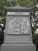
In the Schill Casemate , the two casemate rooms of the main citadel gate, is the place where the eleven Schill officers were brought and sentenced after their capture in Stralsund . A documentary shows the background and relationships of those events to the uprising against Napoleon Bonaparte in 1809. In memory of the eleven Schill officers was on March 31, 1835 Memorial to plans by Karl Friedrich Schinkel at their Hinrichtungs- and burial in the lip reported set up.
The fortress history section of the City Museum in the Citadel Complex shows historical documents, objects of daily use, weapons and images, giving a brief overview of the development of Wesel from the fortified city of the Middle Ages up to and including the First World War.
In the LVR Lower Rhine Museum Wesel in the citadel complex, the history of the Lower Rhine is presented as a cross-border region in Europe today. Another focus of the permanent exhibition is the role of Brandenburg for the region and the city of Wesel as a later Prussian fortress and garrison town.
The old waterworks is a technical monument and gives an impression of the water supply of the city of Wesel from 1886 to 1956. The pumps of the waterworks were operated with steam power and then with electrical energy until 1924 ; They were in operation until 1956. The 40 m high water tower in the city center was also put into operation in 1886 and was connected to the old waterworks on the Lippe by pipes. It served as a water reservoir and at the same time provided the necessary pressure in the pipe network. In 1923 a second tank was created below the existing one. In the tower, which is now cylindrical, there are still large pieces of masonry from the originally conical tower from 1886.
The Bislich museum consists of a local history museum, the Rhein-Deich-Museum and the Ziegeleimuseum, which are housed in a building complex and are each based on local history. The local history museum also includes a natural history exhibition. In 2014, a former forge in Bislich-Marwick was set up as a branch of the museum.
Architectural monuments

The historic town hall was built in 1456 and expanded in 1698/1700 to become the town hall on the Great Market , which was totally destroyed in the Second World War. The facade of the town hall was reconstructed from 2010 to 2011 .
The Wesel Citadel (1688–1722, 1809) was once the largest fortress in the Rhineland . However, there is only one well-preserved remnant of the fortress, facing the city.
The Klever-Tor frieze from 1700 originally comes from the Klever Tor and has been at its current location at the town hall on Klever-Tor-Platz since 1975.
The Berliner Tor is the eastern gate of the former city fortifications. It was built by Jean de Bodt in the Prussian Baroque from 1718 to 1722 . The city side of the gate only exists today as a roofed cube wall. Figures, reliefs and the final trophy 1974 in a damaged and weathered condition have only been preserved on the outside.
"Mourning Vesalia", designed by Eva Brinkman in 1953, is a memorial on the bomb casualty field (honorary cemetery) of the old cemetery in Caspar-Baur-Strasse.
The Peter Minuit monument, created by Hermann Kunkler in 1963, stands on the traffic island at the intersection of Augusta, Bismarck and Moltkestrasse. Peter Minuit was born in Wesel in 1585, was a deacon at Willibrordi Cathedral and founded Nieuw Amsterdam , now New York , in 1626 .
The memorial to the memory of the destruction of Wesel in World War II (1964) by Hans Breeker stands on the edge of the old cemetery at the intersection of Caspar-Baur- and Lipperheystraße.
The under protection of monuments icehouse of the castle Diersfordt dates from the second half of the 18th century and served initially as an oil mill. After a thorough restoration from 1995 by the Diersfordt local history association, the building is now used as a museum and home.
The Herzogschloss am Kornmarkt, built in the 15th century, was completely destroyed in 1945.
Churches
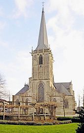
The Protestant Willibrordi Cathedral (1498–1540) on the Great Market is a late Gothic basilica with five naves. The tower was built in 1478.
The Catholic St. John's Church in Bislicher Dorfstraße is a three-aisled Romanesque pillar basilica from the 12th century, which was Gothicized at the end of the 14th century .
The Catholic Church of St. Mary of the Assumption in the Ginderich district was built between 1280 and 1330 as a Romanesque-Gothic basilica.
The Lutherhaus , built in 1729, is the former church of the Lutheran congregation. Today it serves as an evangelical advice center and is used for church and cultural events.
In 1949 the Catholic St. Martini Church at Martinistraße 10 was built on the foundations of a barracks. Altar parts and figures of saints date from the 15th century. In the modern Catholic Church St. Assumption from 1952 is the crypt of the former Dominican church of 1293. Also on the modern religious buildings include the Church of Peace "to the holy angels" (1956-1958) by the architect Hans Schilling in Fusternberger road am Fusternberg , which was built on the foundations of an old fort.
Other church buildings are the Protestant castle church Diersfordt (1775-1780) and the Protestant church Büderich (1835) based on a design by Karl Friedrich Schinkel .
There are two mosques: the Al-Rahman Mosque on Pastor-Bölitz-Straße and the Vatan Mosque on Caspar-Baur-Straße.
Denomination statistics
According to the 2011 census , 40.7% of the population in 2011 were predominantly Roman Catholic , 32.5% Protestant, and 26.8% were non-denominational , belonged to another religious community or did not provide any information. According to a statistical report by the city of Wesel at the end of 2019, 36.2% of the population are Roman Catholic, 28.2% are Protestant and 35.6% belong to another or no religious community.
Kornmarkt
The Kornmarkt is located in the middle of the city a little north of the Willibrordidom . A Franconian estate, which presumably stood on the site of the Kornmarkt in the 8th century, is considered the origin of today's city. In the Middle Ages, the paved square was next to the "large market" one of the largest markets, where mainly grain was traded. In the middle of the square there is a small fountain with the bronze sculptures "Langer Heinrich" and "Bienenkönig", two people from Wesel town history who are reminiscent of this time.
Today the Kornmarkt is mainly known as the pub district of Wesel. The market square is surrounded by bars and restaurants.
Leisure facilities and nature reserves
There are several green spaces in the inner city center, including the Heubergpark and Mölderplatz. At the edge of the city center is the Weseler Glacis , which is a green belt that partially surrounds the city center on former areas of the Wesel Fortress . There are also wooded green strips in the districts of Feldmark and Schepersfeld, which are sometimes referred to as "glacis" based on this.
The Rheinaue Park with a total area of 8.10 km² and 1.559 km² of water includes the Römerwardt glider and motorized airfield, a marina, tennis halls and courts, a mini golf course, a mobile home park, the Auestadion, the heated “RheinBad” and the Auesee lido . The Rheinaue Park is largely a landscape protection area and is made accessible by circular hiking trails.
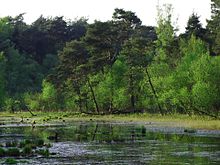
There are two areas with extensive forest areas in the Wesel urban area. It is about the Diersfordter Wald, which extends to the outskirts of Flüren. Its core area is the Diersfordter Wald nature reserve with an area of 9.27 km². The Heideweiher Schwarzes Wasser lies in the middle of a dune landscape . There is also a large game fence in the Diersfordt Forest. In the east of Wesel near the Wittenberg district are the so-called Aaper Busch and the Aaper Vennekes heathland . They are part of the Drevenacker Dunes nature reserve (1.99 km²), whose protected areas extend into the neighboring municipality of Hünxe.
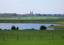
The Bislicher Insel nature reserve (10.53 km² protected area) located on the left bank of the Rhine and partly in the urban area is an important resting place for geese. Further nature reserves located at least partially in the urban area are the areas Bislicher Meer and Wat Ley , Droste Woy, Rheinaue between Wesel and Bislich , Lippeaue , Lipperandsee , renaturation area Büdericher Ziegelei , Rheinaue Bislich-Vahnum , Rheinaue between Büderich and Perrich , Rhine foreland east of Wallach and Weseler Aue and Leygraben near Flüren . These areas are each characterized by their location along the rivers Rhine and Lippe.
Grav island campsite
According to the operator, Germany's largest campsite with 35 kilometers of gravel paths, around 130 employees and an area of more than 2.1 million square meters is located on the Grav Island , located between the Rhine and an oxbow lake . It has two thousand parking spaces for permanent campers and five hundred for day campers.
Cycle tourism
The long- distance cycle routes NiederRheinroute , Rheinradweg , Römerroute , Rundkurs Ruhrgebiet and the “Kulturroute” on Lippe and Issel can be ridden from Wesel. For the city of Wesel there are cycle touring maps with a total of ten thematic routes with explanations of historical and natural history features.
Infrastructure and economy
traffic
Rail and bus transport
The Wesel railway station is located approximately 700 meters southeast of the city center at the Holland route , in Wesel by the Bocholt railway branches.
In rail transport which operate here regional Expresse " Rhein-Express " ( RE 5 ), " Rhein-IJssel-Express " ( RE 19 ), and " Wupperfeld-lip-Express " ( RE 49 ) and the regional trains " Emscher Lower Rhine-Bahn "( RB 35 ) and" Der Bocholter "( RB 32 ) with connections to Emmerich , Arnheim , Duisburg , Mönchengladbach , Krefeld , Oberhausen , Düsseldorf , Wuppertal , Bocholt , Cologne , Bonn and Koblenz .
In addition, Wesel has two further stations, the “Wesel-Feldmark” stop on the line towards Emmerich, which is served by the RE 19, and the “Blumenkamp” stop on the route to Bocholt, which the RB 32 serves.
In local road transport , the express bus lines run from Wesel train station to connect with the communities
- SB 3 Wesel - Hünxe - Dinslaken
- SB 6 Wesel - Xanten
- SB 7 Wesel - Alps - Issum - Geldern
- SB 21 Wesel - Schermbeck - Dorsten
as well as twelve other regional and three city bus routes for spatial and inner-city development, which are operated by NIAG , which is part of the Rhenus-Veniro Group .
The tariff of the Verkehrsverbund Rhein-Ruhr applies to all local public transport and the NRW tariff applies to all tariff areas .
Between November 6, 1914 and December 31, 1966, the Wesel – Rees – Emmerich railway operated .
Streets
Wesel is via the junction 5 Hamminkeln, 6 Wesel and 7 Hünxe of the federal highway 3 ( E 35 ) as well as the junction 6 Alpen of the federal highway 57 ( E 31 ) and the federal roads 8 , 58 (with the only Rhine bridge in the Wesel district at Rheinstrom-km 814), 70 and 473 are connected to the trunk road network. In addition, the urban area is opened up by four state roads.
As part of Bundesstraße 58 , Niederrheinbrücke Wesel crosses the Rhine west of the city center. It was opened to traffic in 2009 and replaced a bridge from the 1950s. The Niederrhein Bridge is a modern cable-stayed bridge with a 130 meter high pylon.
Wesel - since 1995 member of the working group for bicycle-friendly cities and municipalities in North Rhine-Westphalia - offers optimal conditions for non-motorized, individual mobility in close proximity, preferably by bike, on foot, but also with other means of transport (e.g. inline skates, kickboards , Skateboards etc.). In the Germany-wide ADFC bicycle climate test from 2014, which evaluated the bicycle friendliness of cities, Wesel took third place in the category of large medium-sized cities out of 100 cities recorded.
Two ferries operate for pedestrians and cyclists from Easter to October :
- the Rhine ferry "Keer Tröch II" from Wesel- Bislich to Xanten near Rheinstrom-km 823 and
- the Lippe ferry "Quertreiber", a yaw ferry at the level of the RWE Rhein-Ruhr substation .
Waterways and ports
In Wesel, the Wesel-Datteln Canal (length in the city area: 6.7 km) flows into the Rheinstrom (length in the city area: 17 km), which forms the basis for the ports operated, the Rhein-Lippe-Hafen Wesel (Rheinstrom-km 813), the municipal Rhine port of Wesel and the state protective port of Wesel (both Rheinstrom km 815). The Lippe also flows into the Rhine in Wesel, where the Lippe Port of Wesel was operated until the beginning of the 20th century .
air traffic
Wesel has an airfield classified as a special airfield with a grass runway, which is located between the Rhine and the city. The airfield is open regularly on weekends and can be approached by gliders and powered aircraft up to a take-off weight of 2 t.
Companies
The famous Gerhard Adam piano factory was located here until the Second World War .
- The chemical industry is strongly represented in Wesel with Altana Chemie , BYK Chemie , LGC Standards (formerly Promochem) and Oxoid.
- Geberit is a well-known manufacturer of sanitary ceramics.
- The RWE Rhein-Ruhr , where it maintains the Regional Center Niederrhein.
- The two hospitals with their affiliated facilities, the Evangelical Hospital in Wesel and the Marien Hospital in Wesel, are among the largest employers.
media
Print media
The daily newspapers Neue Rhein Zeitung and Rheinische Post as well as the weekly advertising newspaper Der Weseler are each represented by local editorial offices in Wesel. Furthermore, the newspaper mein Wesel appears once a month and the magazine Wir in Wesel once a quarter.
The Christian Kawohl Verlag has been based in Wesel since 1977; also the affiliated music publisher Felsenfest and Edition Hintermann .
Tele and media services
The local radio station Radio KW (Radio Kreis Wesel) broadcasts its program from the Wesel radio studios in the Berlin Tor Center. It can be received in the entire district via the Wesel transmitter on the frequency 107.6 MHz with 200 W ERP and via the Moers telecommunications tower on the frequency 91.7 MHz with 100 W ERP. At the Volkshochschule Wesel there is one of six radio workshops run by Radio KW. Most of the broadcasts of the community radio are produced in these studios . Radio Tele Wesel 1 e. V. is the oldest "new media" association that also publishes community radio and other articles.
Since January 8, 2003, the private youth channel L: S. It offers young people in the Wesel district the opportunity to realize their own television programs. The programs are produced in Haus Lilienveen on Fusternberg. The two studios produce their own formats such as “Sportlive”, the “L: S Box” and numerous entertaining programs. The program is distributed exclusively on the Internet and on digital television by Unity Media NRW. The main focus is on reporting on the Wesel district. The program is mainly aimed at the age group from 12 to 29 years old.
The Wesel transmitter is a transmission system built by the Deutsche Bundespost in 1968 to broadcast VHF, digital radio (DAB) and television programs (DVBT) on Perricher Weg in the Ginderich district. A 320.80 meter high, guyed steel framework mast, which is the tallest structure in North Rhine-Westphalia , serves as the antenna carrier . Today the transmission system belongs to the Telekom subsidiary DFMG Deutsche Funkturm GmbH .
The telecommunications tower "Langer Heinrich" was built in 1983 by the Deutsche Bundespost on Berliner-Tor-Platz. The lower platform is 99.95 m high, the upper platform 108.20 m high. It has a total height of 158 m above level ( 184 m above sea level ) and is the tallest structure in the city center.
The broadcaster KW-Loakl.TV opened a TV studio in the Kolping House in Wesel in 2014 . He can only be reached via the Internet.
telecommunications
In addition to Deutsche Telekom AG, the largest alternative full- line access provider Arcor has also been offering 0281 landline connections ( ISDN / DSL ) in the Wesel area code since the 2nd quarter of 2007 . Arcor is one of the telephone providers who have their own landline network down to the level of the local exchange, but from there use the Deutsche Telekom connection lines.
Public facilities
Authorities and a.
Wesel is home to the Wesel district building, the seat of the Wesel district , and Wesel is also the seat of the Wesel district police authority . Furthermore, who Employment Agency , the job center Wesel, the District Court of Wesel and the Labor Court Wesel based in Wesel, as well as the German Red Cross , the Johanniter accident assistance , the Malteser the Kreishandwerkerschaft , the tax office and the State Forestry Office . The construction and real estate company NRW, the Rhineland Chamber of Agriculture , the State Office for Road Construction North Rhine-Westphalia , the Technical Monitoring Association , the Lower Rhine Chamber of Commerce and Industry , the Water Police and the Federal Agency for Technical Relief (THW) are represented with a district office, branch or branch in Wesel .
Wesel is a NATO and Bundeswehr location . In the Schill barracks , among others, is German share of the 1st NATO Signal Battalion stationed. The 284 telecommunications battalion previously stationed in Wesel was disbanded and transferred to the 1st NATO Signal Battalion as a German component.
Hospitals, old people's homes
There are two hospitals in Wesel : the Evangelical Hospital with 305 beds and the Marien Hospital with 422 beds. There are also two rehabilitation centers and five retirement homes .
Advice centers
In Wesel there are various advice centers for AIDS help , the Arbeiterwohlfahrt , the Caritas Association , the German Child Protection Association , the DGB , the Diakonisches Werk , the International Association , the Social Service of Catholic Women , the VdK , the NRW consumer center and the White Ring , the Multi-generation house Wesel and the telephone pastoral care .
Sports
There are various sports facilities in Wesel, including the Auestadion as an athletics base and the Lippe Stadium, which is mostly used for soccer games, an ice rink, several sports halls as well as swimming pools and leisure pools. There is also the Wesel-Römerwardt sports airfield and the Wesel yacht harbor . The Auestadion, the airfield and the marina are all located in the Rhine-Aue area, where the Auesee , which is suitable for water sports, and the RheinBad outdoor pool are additional sports facilities. The river Lippe, which also runs along the town, is suitable for canoeing.
In February 2017 there were 90 different sports clubs in the city. The sports offered included badminton, basketball, billiards, boxing, fitness, football, futsal handball, various martial arts, canoeing, running, athletics, air sports (e.g. gliding), equestrian sports, rowing, chess, shooting sports, swimming, sailing, Surfing, dancing, tennis, table tennis, gymnastics, volleyball, yachting and a number of other sports.
The currently most successful soccer club in the city is PSV Wesel-Lackhausen , other well-known soccer clubs are Weseler SV and BSV Viktoria Wesel. The city of Wesel played a particularly important role in the expansion of the football-based sport futsal. In 2005, the first game in the history of the WFLV Futsal League took place in Wesel when the Inter Futsal Wesel match against UFC Münster . This is the top division of this sport. The club Inter Futsal Wesel, which was later integrated into PSV Wesel-Lackhausen, took second place in their first season .
In addition to the Weseler SV football club, the Auestadion is occupied by the athletes from Weseler TV . In addition to its well-known athletics department, from which Ludwig Müller and Michael Möllenbeck emerged , among others , the WTV has eight other departments. As a pure badminton club, BV Wesel Rot-Weiss currently plays in the Regionalliga West and was a member of the 1st Bundesliga in the 2001/02 season. The rowing and tennis company Wesel , which was founded in 1907, includes several sports on the water and a tennis department and is located in the Rhine-Aue area. In the district of Flüren there is an association called BSV Grün-Weiß Flüren whose athletics department has achieved significant successes with Heinz-Ulrich Schulze and Manfred Brucks, among others . The TC Blau-Weiß Wesel-Flüren tennis club, which is based in the same district , had a men's 30 team playing in the 1st Bundesliga at times. In the equestrian sport there are several clubs in the Wesel city area, including the RV Obrighoven as the organizer of important tournaments.
education
Wesel has a Protestant elementary school, three Catholic elementary schools and ten community elementary schools as well as one special school each for the mentally handicapped, the learning handicapped, the speech handicapped and the hard of hearing. Since the beginning of the 2006/07 school year, the school offer has been supplemented by a Montessori school as a private substitute school .
In the secondary level there is the vocational college Wesel, a comprehensive school, two high schools (the Andreas-Vesalius-Gymnasium and the Konrad-Duden-Gymnasium ), a secondary school and two secondary schools.
In the further education area, the offer is rounded off by an evening grammar school, the music and art school, the study center of the Hagen Open University and the adult education center. The FOM University of Economics & Management has also had a university study center in Wesel since 2012 . In addition, there are three family education centers sponsored by the Arbeiterwohlfahrt, the Diakonisches Werk and the Catholic Church.
Personalities
Honorary citizen
- 1895: Prince Otto von Bismarck (* 1815; † 1898), Prussian Prime Minister and first Chancellor of the German Empire
- 1914: Georg Freiherr von Rheinbaben (* 1855; † 1921), District President in Düsseldorf, Prussian Interior Minister and Finance Minister, Upper President of the Rhine Province, friend and sponsor of the city of Wesel
- 1917: Paul von Hindenburg (* 1847, † 1934), Field Marshal General and President of the Reich from 1925 until his death
- 1926: Moritz Schneemann (* 1836; † 1930), long-time city councilor and alderman of the city of Wesel
- 1929: Karl Neuhaus (* 1838; † 1931), alderman and councilor of the city of Wesel
- 1931: Ludwig Poppelbaum (* 1866; † 1940), mayor of the city of Wesel from 1903 to 1931
- 1951: Josef Janßen (* 1881; † 1966), pastor at St. Mary's Assumption in Wesel, dean, papal house prelate, cathedral chapter and episcopal commissioner for the Lower Rhine
- 1952: Johannes Boelitz , (* 1868, † 1959), pastor at Willibrordi Cathedral from 1918 to 1933 and author of writings on local history
- 1966: Franz Etzel (* 1902, † 1970), Federal Minister of Finance and Vice President of the Montan Union
- 1976: Karl-Heinz Reuber (* 1906, † 1982), City Director of Wesel from April 1, 1950 to November 30, 1970, "the main engine and the greatest pacemaker of reconstruction"
- 1995: Hans Tienes (* 1906; † 2004), entrepreneur and cultural promoter
- 2006: Wilhelm Schneider (* 1926; † 2007), politician, including former mayor of Wesel
- 2012: Krzysztof Hećman (* 1960), Mayor of Wesel's twin town Kętrzyn , sponsor of the town twinning and youth exchange between the two towns
- 2016: Ernest Kolman (* 1926), former Jewish citizen of Wesel (fled to England in 1938) with merits for the work of remembrance and reconciliation
On April 4, 1933, Adolf Hitler was also granted honorary citizenship of Wesel "for his services to the people and fatherland", which was formally revoked on September 13, 1983 by a unanimous resolution of the city council. At the same time, Ludwig Poppelbaum's revocation of honorary citizenship during the Nazi era was formally declared null and void.
Often as a preliminary stage to honorary citizenship, the city of Wesel has also been awarding a ring of honor for special services to the common good since 1970, which was last awarded in September 2000 for the 25th time.
sons and daughters of the town
- Derick Baegert (* around 1440; † after 1502), important painter from the Lower Rhine region of the late Middle Ages
- Jan Joest (* around 1455, † after 1519), Wesel painter
- Arnoldus Vesaliensis (around 1484; † 1534), humanist
- Bartholomäus Bruyn the Elder (* 1493; † 1555), important portraitist
- Friedrich Knebel († 1574), Lübeck councilor and admiral of the fleet in the three-crown war
- Reiner Solenander (* 1524 in Büderich ; † 1601), balneologist and personal physician to Wilhelm the Rich
- Tilemann Hesshus (* 1527; † 1588), Lutheran theologian
- Laurenz of Brachum (* first half of the 16th century as Lauren (t) z Steynhower; † 1586), builder , architect and founder of the lip Renaissance
- Hans Lipperhey (* around 1550 - † 1619), inventor of the telescope
- Gottfried Schlüter the Elder (* 1567, † 1637), Lutheran theologian, Superintendent of Oldenburg
- Peter Minuit (around 1580/85; † 1641), alleged founder of New Amsterdam ( New York )
- Theodor Roos (* 1638; † 1698), history and portrait painter
- Philipp Karl von Wylich and Lottum (1650–1719), Prussian field marshal
- Johann Arnold Nering (* 1659; † 1695), architect of the Electorate of Brandenburg
- Isaak Jacob von Petri (* 1705; † 1776), architect, builder of the Berlin Invalidenhaus
- Friedrich Georg Christoph von Hellermann (* 1723; † 1794), District Administrator of the Fürstenthum district in Western Pomerania
- Matthias Jorissen (* 1739; † 1823), reformed pastor and hymn poet
- Johann Heinrich Achterfeld (* 1788; † 1877), Catholic theologian, professor and editor
- Friedrich Christian Eugen Baron von Vaerst (* 1792; † 1855), officer, later writer and gastrosoph
- Friedrich Wilhelm Bilefeldt (* 1794; † 1848), officer, later district administrator of the Lechenich / Euskirchen district
- Johann Jakob Ewich (* 1788; † 1863), Protestant educator
- Friedrich Bird (* 1791; † 1851), psychiatrist and medical writer
- Johann Friedrich Welsch (* 1796; † 1871), important painter of the 19th century
- Adolf Brix (* 1798; † 1870) was a Prussian mathematician and engineer
- Heinrich von Rosenthal (* 1808; † 1865), politician
- Karl Friedrich Hering (* 1818; † 1896), Consistorial President of the Westphalian part of the Evangelical Church of Prussia
- Josef Schex (* 1819; † 1894), history and genre painter from the Düsseldorf School of Painting
- Heinrich von Knapp (* 1827; † 1904), soap manufacturer and member of the Prussian House of Representatives
- Hugo Lent (* 1827; † 1915), architect and railroad builder
- Gerhard Schneemann (* 1829; † 1885), theologian and church historian
- Konrad Duden (* 1829; † 1911), promoter of uniform German spelling
- Karl Hermann Peter von Thielen (* 1832; † 1906), politician
- Ludwig Hugo Becker (* 1833; † 1868), painter, draftsman and etcher
- Friedrich Geselschap (* 1835; † 1898), history painter of the late 19th century
- August Bagel (* 1838; † 1916), entrepreneur in the publishing and printing business
- Heinrich Hart (* 1855; † 1906), author and naturalistic literary and theater critic
- Arnold Meyer (* 1861; † 1934), theologian and university professor
- Wilhelm Schreuer (* 1866; † 1933), painter
- Curt Liebich (* 1868; † 1937), sculptor, professor, honorary citizen of the city of Gutach (Black Forest Railway)
- Martin Boelitz (* 1874; † 1918), writer
- Hans Adam (* 1883; † 1948), naval officer and submarine commander
- August Asmuth (* 1884; † 1935), politician (center), member of the Reichstag
- Max Otto Luyken (* 1885 - † 1945), farmer and politician (NSDAP)
- Friedrich Wilhelm Janssen (* 1887; † 1956), manager of Friedrich Krupp AG
- Hugo ten Hövel (* 1890; † 1953), politician
- Maria Kahle (* 1891; † 1975), writer
- Bernhard Schweitzer (* 1892; † 1966), classical archaeologist
- Joachim von Ribbentrop (* 1893; † 1946), German Foreign Minister from 1938 to 1945
- Heinrich Nickel (* 1894; † 1979), officer, most recently lieutenant general
- Otto Bräutigam (* 1895; † 1992), lawyer and diplomat
- Artur Buschmann (* 1895 - † 1971), painter
- Ida Noddack-Tacke (* 1896; † 1978), discoverer of the chemical element rhenium
- Hilde Löhr (* 1897, † 1998), photographer
- Erich Schulte Mönting (* 1897, † 1976), naval officer, ship commander, most recently vice admiral in World War II
- Erich Leyens (* 1898; † 2001), businessman and author, who became known through resistance against the " Jewish boycott "
- Manfred Monjé (* 1901; † 1981), sensory physiologist
- Franz Etzel (* 1902; † 1970), Federal Minister of Finance and Vice President of the Montan Union
- Ernst-Alfred Jauch (* 1920; † 1991), Catholic journalist, father of the TV presenter Günther Jauch
- Walter Schmithals (* 1923; † 2009), theologian
- Erich Klinge (* 1925; † 1998), lawyer and association official
- Friedrich Carl Trapp (* 1930; † 2020), building contractor
- Otti Pfeiffer (* 1931; † 2001), writer
- Heinz Robert Schlette (* 1931), philosopher and theologian
- Ludwig Müller (* 1932), athlete
- Franz Müller-Heuser (* 1932; † 2010), concert singer
- Heribert Beissel (* 1933), conductor
- Dieter Schaub (* 1937), entrepreneur and publisher
- Alfred Post (* 1942; † 2005), legal scholar
- Lilo Friedrich (* 1949), politician
- Rainer Neu (* 1950), theologian, religious scholar and sociologist
- Michael Karas (* 1952), German scientist
- Jan Hofer (* 1952 in today's Büderich district ), daily news announcer
- Burkhard Ducoffre (* 1954), diplomat
- Sabine Boeddinghaus (* 1957), politician (Die Linke)
- Uwe Ecker (* 1960), jazz drummer
- Dieter Nuhr (* 1960), cabaret artist and comedian
- Thomas Terstegen (* 1960), ambassador
- Uwe Vengels (* 1960), soccer player
- Christoph Gerwers (* 1963), Mayor of Rees
- Hermann-Josef Tenhagen (* 1963), journalist
- Thomas Möllenbeck (* 1966), priest and theologian
- Andre Klump (* 1968), Professor of Romance Linguistics at the University of Trier
- Michael Möllenbeck (* 1969), track and field athlete and Olympic participant
- Martin Bambauer (* 1970), church musician
- Bernd Reuther (* 1971), politician (FDP)
- Bodo Wißen (* 1974), politician (SPD)
- Ben Bernschneider (* 1976), author, director and photographer
- Oliver Uschmann (* 1977), writer
- Mareen Hufe (* 1978), triathlete
- Aljoscha Brell (* 1980), writer
- Elyasa Süme (* 1983), soccer player
- Tristan Angenendt (* 1985), classical guitarist
- Dennis Kempe (* 1986), soccer player
- Mirko Boland (* 1987), soccer player
- Frederike Koleiski (* 1987), track and field athlete
- Tobias Kempe (* 1989), soccer player
- Inka Wesely (* 1991), soccer player
Other personalities who worked or are working in Wesel
- Konrad Heresbach (* 1496; † 1576), humanist and prince tutor at the court of the Duke of Kleve
- Friedrich Spee von Langenfeld (* 1591; † 1635), from autumn 1627 Spee taught at the college in Wesel
- Wilhelm Hüls (* 1598; † 1659), Reformed theologian
- Johann Heinrich Schmucker (* 1684; † 1756), Reformed theologian
- Friedrich Wilhelm von Steuben (* 1730, † 1794) Prussian officer and American general, reorganized Continental Army, was stationed in Wesel
- Karl Georg Maaßen (* 1769; † 1834), Prussian politician, co-initiator of the German Customs Union , grew up in Wesel
- Gustav von Rauch (* 1774; † 1841), Prussian general of the infantry and general inspector of the Prussian fortresses, later Minister of War , had the Wesel fortress expanded
- Daniel Friedrich Eduard Wilsing (* 1809; † 1893), German Romantic composer, between 1829 and 1834 organist at the main Protestant and Mathena Church in Wesel
- August Willich (* 1810; † 1878), Prussian and American officer, one of the leaders of the Baden uprising, was stationed in Wesel
- Mathilde Franziska Anneke (* 1817; † 1884), German writer, journalist and women's rights activist, lived in Wesel
- Fritz Anneke (* 1818, † 1872), Prussian and American officer, founder of the Cologne workers' association (forerunner of the SPD), was stationed in Wesel
- Edward Millard (* 1822; † 1906) was director of the Austrian Bible Society in Vienna and a Baptist clergyman. He spent his old age in Wesel.
- August Kind (* 1824; † 1904), architect and building officer of the Reichspost , lived and worked in Wesel from 1853 to 1856 as a master builder
- Friedrich Ebert (* 1871; † 1925), Reich President, completed an apprenticeship in saddlery in Wesel
- Karl Straube (* 1873; † 1950), organist at Willibrordi Cathedral
- Hermann Ludwig Blankenburg (* 1876, † 1956), Germany's March King
- Hans Jauch (* 1883; † 1965), Colonel and Freikorpsführer, chairman of the church building association for the reconstruction of St. Martini zu Wesel
- Gerhard Storm (* 1888; † 1942), priest, martyr of the Catholic Church . From 1913 to 1920 he worked as a chaplain in the St. Martini parish in Wesel
- Heinrich Schmitz (* 1890; † 1968), Protestant pastor and member of the professing church
- Otto Pankok (* 1893; † 1966), painter, draftsman and sculptor
- August Oppenberg (* 1896; † 1971), painter of the Lower Rhine and its people, lived in Wesel
- Erna Suhrborg (* 1910; † 1995), painter, lived in Wesel until her death
- Heinz Bello (* 1920; † 1944), Catholic martyr, high school graduate at the state high school for boys in Wesel
- Wolfgang Deurer (* 1934), architect, monument conservator and master builder in Wesel
- Inge von Bönninghausen (* 1938), journalist and feminist, attended high school in Wesel
- Eckehardt Knöpfel (* 1946), publicist, author and educator; 1995 - 2003 Chairman of the Association of Pedagogy Teachers
- Egon Ramms (* 1948), Bundeswehr General, Abitur at the state high school for boys in Wesel
- Ludger Jochmann (* 1952), author mainly of children's books, lives in Wesel
- Gabriele Suhrborg b. Saigge (* 1959), artist, has lived in Wesel since she was born
- Angelique Damschen (* 1967), German singer
- Dolly Buster (* 1969), Czech producer, director, actress, ex-porn actress and author, lives in Wesel
literature
- Annegret Dahmen: Chronicle 1945 to 1999: 55 years of Wesel history (= studies and sources on the history of Wesel 22). Stadtarchiv, Wesel 1999, ISBN 3-924380-17-1 .
- Jutta Prieur (ed.): History of the city of Wesel: Contributions to the city history of the early modern period (= studies and sources on the history of Wesel 20). Stadtarchiv, Wesel 1998, ISBN 3-924380-15-5 .
- Jutta Prieur (Ed.): Home Front Wesel 1939–1945: Women and men remember the war in their city (= studies and sources on the history of Wesel 16). Stadtarchiv, Wesel 1994, ISBN 3-924380-11-2 .
- Martin W. Roelen (Ed.): Ecclesia Wesele: Contributions to place name research and church history (= studies and sources on the history of Wesel 28). Stadtarchiv, Wesel 2005, ISBN 3-924380-23-6 .
- Veit Veltzke: Prussian fortress Wesel: politics, war and art (= the historical place: fortresses 87). Kai Homilius Verlag , Berlin 2001, ISBN 3-931121-86-0 .
- Josef Voigt: fortress guide through the fortress remains of the city of Wesel . Self-published, Wesel 1996.
- Yearbook Wesel District 2013 . Mercator-Verlag, Duisburg 2012. ISBN 978-3-87463-514-1 .
Trivia
On May 25, 1982, the crew of a British phantom fighter accidentally shot down another Royal Air Force fighter aircraft over Wesel. The Phantom's pilot had forgotten he had live ammunition on board. The Jaguar hit by an air-to-air missile crashed into a field not far from the RWE substation. The pilot, Flt.Lt Griggs, was able to save himself with the ejection seat.
Web links
Individual evidence
- ↑ Population of the municipalities of North Rhine-Westphalia on December 31, 2019 - update of the population based on the census of May 9, 2011. State Office for Information and Technology North Rhine-Westphalia (IT.NRW), accessed on June 17, 2020 . ( Help on this )
- ↑ a b Geographical data (wesel.de)
- ↑ a b Cadastral area in North Rhine-Westphalia in 2006 and 2016 according to selected types of use (it-nrw.de)
- ↑ Agricultural area in NRW has decreased by 608 square kilometers in the last ten years (it-nrw.de)
- ↑ a b Population figures wesel.de, accessed on March 24, 2020.
- ↑ Christoph Reichmann: Where was Lippeham? Unser Bocholt 3-4, 1980, pp. 44-48.
- ^ Frank Siegmund: Merovingian time on the Lower Rhine. Rheinische Ausgrabungen 34. Rheinland-Verlag, Cologne 1998, p. 438, plate 219. ISBN 3-7927-1247-4
- ^ Camillus Wampach : Document and source book of the old Luxembourg territories up to the Burgundian period. Luxemburg 1935-55, I.2, p. 102 with no.41.
- ^ Hugo Borger: The excavations in the Willibrord Church in Wesl. Der Niederrhein 31, 1964, pp. 91-96. - W. Zimmermann, in: Bonner Jahrbücher 158, 1958, 451 No. 4.
- ^ Camillus Wampach: Document and source book of the old Luxembourg territories up to the Burgundian period. Luxemburg 1935-55, I.2, p. 102 with no.193.
- ↑ a b September 1241 - Granting of city rights , wesel.de, accessed on September 11, 2016.
- ^ Theodor Joseph Lacomblet, in: Document book for the history of the Lower Rhine or the Archbishopric of Cologne, documents 258 , 1846, volume 2, 1201 to 1300, p. [170] 132.
- ↑ kirchensite.de
- ↑ Cf. Theodor Fontane , Wanderings through the Mark Brandenburg. I, Munich / Vienna ³1987, p. 835.
- ↑ Josef Stübben : The city expansion of Wesel . In: Deutsche Bauzeitung , vol. 25, no. 3 (January 10, 1891), pp. 13–15 with illustration on p. 17. ( urn : nbn: de: kobv: co1-opus-24540 )
- ↑ Walks of a gable frieze (wesel.de)
- ↑ Volker Kocks: The Weseler Railway Bridge, in Jürgen Becks / Martin Wilhelm Roelen (eds.): Eisenbahnen am Niederrhein, Wesel 2005, ISBN 3-924380-75-9 .
- ↑ Internet portal of the LVR: Rhenish subjects and explanation of the dialect boundaries ( Memento of May 3, 2012 in the Internet Archive ) Website accessed on October 10, 2013
- ↑ Internet portal of the LVR: Explanations on the subject of Regiolect in the Rhineland ( Memento from June 20, 2012 in the Internet Archive ) Website accessed on October 10, 2013
- ↑ Martin Bünermann: The communities of the first reorganization program in North Rhine-Westphalia . Deutscher Gemeindeverlag, Cologne 1970, p. 104 .
- ^ Federal Statistical Office (ed.): Historical municipality directory for the Federal Republic of Germany. Name, border and key number changes in municipalities, counties and administrative districts from May 27, 1970 to December 31, 1982 . W. Kohlhammer, Stuttgart / Mainz 1983, ISBN 3-17-003263-1 , p. 297 .
- ↑ State Returning Officer NRW: Local elections 2014: Final result for Wesel
- ↑ Quartet turns its back on the CDU , on derwesten.de
- ↑ The WWW dissolves and changes to the SPD , Rheinische Post from November 5, 2016
- ↑ Wesel city flag on the Berliner Tor . Wikimedia Commons
- ↑ Main statute of the city of Wesel, §2 ( Memento of February 24, 2016 in the Internet Archive ). City of Wesel
- ↑ Highlight events (wesel-tourismus.de)
- ^ Hanne Buschmann: Wesel: First Erna Suhrborg Prize awarded. Retrieved March 21, 2017 .
- ^ City of Wesel Religion , 2011 census
- ↑ Hanseatic City of Wesel am Rhein Population figures as of December 31 , 2019 , accessed on January 14, 2020
- ↑ Stadt Wesel Opendata Religious affiliations in the districts , accessed on June 18, 2020
- ↑ Glacis facility in Weseler Feldmark (ratsinfo.wesel.de)
- ↑ Wesel: A glacis is the opposite of forest (rp-online.de)
- ↑ The largest family campsite is in Wesel derwesten.de, June 2, 2009, accessed on July 3, 2014
- ↑ Grav-Insel: Camping happiness on 2.1 million square meters Focus, June 6, 2009
- ↑ ADFC bike climate test 2014 city ranking (adfc.de)
- ↑ Hautnah 250, Reinhard Kawohl, 40 years of Kawohl ... , on de.cross.tv
- ↑ a b clubs , on wesel.de, accessed on June 25, 2020
- ↑ PSV Wesel Futsal represents the Wesel district at NRW level! (lokalkompass.de)
- ↑ RV Obrighoven: Dressage at the highest level (rp-online.de)
- ↑ 2004: Former of the KDG: Egon Ramms has the third general star Konrad-Duden-Gymnasium Wesel

