
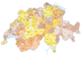
District (Switzerland)
In the federalist structure of Switzerland , the state is completely free in its internal organization. There is also a variety of organizational structures and terms for a level between canton and municipality , which can also be missing. It is often called a district , in certain cantons also an administrative region, administrative district, constituency, amtei or office, in the French-speaking part of the country district , in the Italian part of the country distretto , in the Rhaeto-Romanic part of the country districts . The head of a district office is called a district administrator, district administrator, governor or governor.
As a rule, the district only serves to decentralize the cantonal administration and court organization. In the canton of Schwyz , on the other hand, for historical reasons, the districts are separate legal entities with tax sovereignty and, in some cases, their own commune . A similar role was played earlier in the canton of Grisons , the circles (Romanesque circul , Mz. Circuls or Italian circolo , Mz. Circoli ). In the canton of Appenzell Innerrhoden , district is the name for the lowest administrative unit, i.e. the political municipality .
Overview
(Order of the cantons according to Art. 1 of the Federal Constitution of the Swiss Confederation )
As of January 1, 2018


| Canton | Administrative unit | number |
|---|---|---|
|
|
Districts | 12 |
|
|
Administrative districts Administrative regions |
10 5 |
|
|
- *) | - *) |
|
|
- | - |
|
|
Districts | 6th |
|
|
- | - |
|
|
- | - |
|
|
- | - |
|
|
- | - |
|
|
Districts | 7th |
|
|
Offices *) | 5 *) |
|
|
- | - |
|
|
Districts | 5 |
|
|
- *) | - *) |
|
|
- *) | - *) |
|
|
- | - |
|
|
- *) | - *) |
|
|
Regions | 11 |
|
|
Districts | 11 |
|
|
Districts | 5 |
|
|
Districts districts |
8 37 |
|
|
Districts | 10 |
|
|
Districts | 14th |
|
|
- | - |
|
|
- | - |
|
|
Districts | 3 |
*) The Federal Statistical Office (FSO) provides for additional units in these cantons, which as a rule continue formally earlier district structures; see the following canton chapters. However, these are not districts within the meaning of cantonal constitutional law.
Former districts of Switzerland

until December 31, 1960
January 1, 1961 -
December 31, 1975
January 1, 1976 -
December 31, 1978
January 1, 1979 -
December 31, 1985
January 1, 1986 -
December 31, 1989
January 1, 1990 -
December 31, 1990
January 1, 1991 -
December 31, 1991
January 1, 1992 -
December 31, 1993
January 1, 1994 -
December 31, 1994
January 1, 1995 -
December 31, 1995
January 1, 1996 -
June 30, 1996
July 1, 1996 -
December 31, 1996
January 1, 1997 -
December 31, 1997
January 1, 1998 -
December 31, 1999
January 1, 2000 -
December 31, 2000
January 1, 2001 -
December 31, 2002
January 1, 2003 -
December 31, 2004
January 1, 2005 -
December 31, 2007
April 20, 2008 -
December 31, 2008
January 1, 2009 -
December 31, 2009
January 1, 2010 -
November 20, 2013
November 21, 2010 -
December 31, 2013
January 1, 2011 -
December 31, 2013
January 1, 2013 -
December 31, 2015
January 1, 2016 -
June 30, 2016
July 1, 2016 -
December 31, 2016
January 1, 2017 -
April 1, 2017
April 2, 2017 -
December 31, 2017
January 1, 2018 -
December 31, 2018


Former districts and districts of Switzerland

until December 31, 1960

Jan. 1, 1961 -
April 22, 1972
April 23, 1972 -
December 31, 1975
January 1, 1976 -
December 31, 1978
January 1, 1979 -
December 31, 1985
January 1, 1986 -
December 31, 1989
January 1, 1990 -
December 31, 1990
January 1, 1991 -
December 31, 1993
January 1, 1994 -
December 31, 1994
January 1, 1995 -
December 31, 1995
January 1, 1996 -
June 30, 1996
July 1, 1996 -
December 31, 1996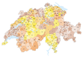
January 1, 1997 -
December 31, 1997
January 1, 1998 -
December 31, 1999
January 1, 2000 -
December 31, 2000
January 1, 2001 -
December 31, 2002
January 1, 2003 -
April 3, 2004
April 4, 2004 -
December 31, 2004
January 1, 2005 -
December 31, 2007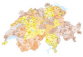
January 1, 2008 -
December 31, 2008
January 1, 2009 -
April 4, 2009
April 5, 2009 -
December 31, 2009
January 1, 2010 -
November 20, 2010
November 21, 2010 -
December 31, 2010
January 1, 2011 -
March 31, 2012
April 1, 2012 -
December 31, 2012
January 1, 2013 -
April 13, 2013
April 14, 2013 -
December 31, 2013
January 1, 2014 -
December 31, 2014
January 1, 2015 -
December 31, 2015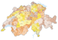
January 1, 2016 -
April 9, 2016
April 10, 2016 -
June 30, 2016
July 1, 2016 -
December 31, 2016
January 1, 2017 -
April 1, 2017
April 2, 2017 -
December 31, 2017
January 1, 2018 -
December 31, 2018


Elimination of districts in twelve cantons, reduction of the number of districts in other cantons
Twelve of the 26 cantons do without the district level (understood as an administrative unit between the canton and the communes):
- It has always been the eight cantons of Uri , Obwalden , Nidwalden , Glarus , Zug , Appenzell Innerrhoden , Basel-Stadt and Geneva , be it for historical reasons or for practical reasons, because the area is small enough.
- More recently have abolished the districts
- the canton of Appenzell Ausserrhoden 1995,
- the canton of Schaffhausen in mid-1999,
- the canton of St. Gallen at the beginning of 2003,
- the canton of Solothurn 2005; the previous offices, however, which each combine two districts, still exist,
- the canton of Lucerne with the new cantonal constitution of 2007,
- the canton of Neuchâtel on January 1, 2018.
The cantons of Appenzell Ausserrhoden, Schaffhausen, Solothurn and Lucerne, however, continue to run the former districts or the new constituencies as units for statistical purposes, as does the canton of Neuchâtel its four previously existing regions.
A reduction was made in the following cantons:
- In the canton of Graubünden , the former 14 districts were reduced to 11 on January 1, 2001 (these regions have been named since 2016 ). In addition, the previous districts were abolished at the beginning of 2016 (exceptionally at the beginning of 2018).
- In the canton of Vaud , the reduction from 19 to ten districts took place on January 1, 2008.
- In the canton of Bern , the 26 administrative districts were replaced on January 1, 2010 by five administrative regions, which in turn are divided into ten administrative districts.
- In the canton of Thurgau , the eight previous districts were replaced on January 1, 2011 by five newly defined districts.
The abolition or reduction failed in the following cantons:
- In May 2006, the abolition of the districts was discussed in Canton Schwyz . The so-called G reform failed, however, because the people ultimately decided in favor of the continued existence of the districts.
- In the canton of Friborg , a reduction in the number of districts in 2010 was declared a failure by the State Council as a result of regional resistance.
- In the canton of Valais , a new canton constitution is also considering reducing the number of districts.
List of districts in Switzerland by cantons
(Order of the cantons according to the federal constitution , areas according to the Federal Statistical Office)

Canton Zurich
The canton of Zurich is divided into twelve districts :

| district | Population (December 31, 2018) |
Area in km² |
main place | Number of municipalities |
|---|---|---|---|---|
| Affoltern | 54,619 | 113.03 | Affoltern am Albis | 14th |
| Andelfingen | 31,372 | 166.54 | Andelfingen | 22nd |
| Bulach | 151,486 | 184.88 | Bulach | 22nd |
| Dielsdorf | 90,455 | 152.85 | Dielsdorf | 22nd |
| Dietikon | 91,091 | 60.11 | Dietikon | 11 |
| Hinwil | 95,711 | 179.50 | Hinwil | 11 |
| Horgen | 124,801 | 104.24 | Horgen | 9 |
| miles | 104,412 | 84.62 | miles | 11 |
| Pfaffikon | 60'439 | 163.15 | Pfaffikon | 10 |
| Uster | 131,702 | 112.23 | Uster | 10 |
| Winterthur | 169,513 | 251.75 | Winterthur | 19th |
| Zurich | 415,367 | 87.93 | Zurich | 1 |
| Total (12) * | 1,520,968 | 1728.94 | Zurich | 162 |
- The land area of the Canton of Zurich is 1660.83 km², plus a lake area of 68.11 km², so the total area is 1728.94 km² (Greifensee 8.30 km², Zurich Lake 59.81 km²). The Pfäffikersee measures 3.30 km², seven other bodies of water together measure 1.22 km².

Districts of the canton of Zurich until December 31, 1985

Districts of the Canton of Zurich until June 30, 1989


- Until December 31, 1985, the Zollikon community was assigned to the Zurich district.
- Until June 30, 1989, the eleven municipalities of today's Dietikon district were assigned to the Zurich district.
- Due to the exchange of land on January 1, 2013 of the hamlet “Obere Hueb” in the municipality of Buch am Irchel in Neftenbach , the area of 0.05 km² changes from the Andelfingen district to the Winterthur district.

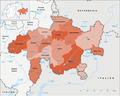
Canton Bern
The canton of Bern is organized since 1 January 2010 in five administrative regions and ten administrative districts. In Art. 39a of the Act on the Organization of the Government Council and Administration (Organization Act), these are referred to as the "ordinary decentralized administrative units of the canton". With the reform of the decentralized administration, which was approved in a referendum on September 24, 2006 with a majority of 58.3%, the administrative districts established around 200 years ago lost their practical function.


| Administrative region | Administrative district | Population (December 31, 2018) |
Area in km² |
main place | Number of municipalities January 1, 2015 |
|---|---|---|---|---|---|
| Bernese Jura | Bernese Jura | 53,721 | 541.73 | Courtelary | 40 |
| Bern-Mittelland | Bern-Mittelland | 414,658 | 943.46 | Ostermundigen | 77 |
| Emmental-Oberaargau | Emmental | 97'218 | 690.41 | Langnau in the Emmental | 40 |
| Emmental-Oberaargau | Oberaargau | 81,759 | 690.41 | Cheeks on the Aare | 45 |
| Oberland | Frutigen-Niedersimmental | 40,375 | 773.63 | Frutigen | 13 |
| Oberland | Interlaken-Oberhasli | 47,387 | 1229.31 | Interlaken | 28 |
| Oberland | Obersimmental-Saanen | 16,588 | 574.88 | Saanen | 7th |
| Oberland | Tuna | 107'491 | 321.97 | Tuna | 31 |
| Zealand | Biel / Bienne | 101,313 | 97.57 | Biel / Bienne | 19th |
| Zealand | Zealand | 74,467 | 336.76 | Aarberg | 42 |
| Total (5) | Total (10) | 1,034,977 | 5,959.51 | Bern | 342 |
The land area of the Canton of Bern is 5,840.54 km². In addition, there is a lake area of 118.98 km² (Thunersee 47.85 km², Brienzersee 29.77 km², proportion: Bielersee 39.17 km² and Neuchâtel lake 2.19 km²). The total area of the canton of Bern is 5,959.52 km².
Until December 31, 2009, the 26 administrative districts (French: district ) formed the canton's decentralized administrative units. According to the Organization Act , they still exist today, but only the law on the special statute of the Bernese Jura and the French-speaking minority of the bilingual district of Biel (special statute law) assigns them a practical function , as the Bernese districts continue to have the electoral districts for the election of the Form the Bern Jurassic Council (BJR).

| district | Area in km² |
main place | Number of municipalities |
|---|---|---|---|
| Aarberg | 152.68 | Aarberg | 12 |
| Aarwangen | 154.02 | Aarwangen | 24 |
| Bern | 233.27 | Bern | 13 |
| Biel | 24.89 | Biel / Bienne | 2 |
| Büren | 87.66 | Büren on the Aare | 14th |
| Burgdorf | 197.30 | Burgdorf BE | 24 |
| Courtelary | 266.08 | Courtelary | 18th |
| Erlach | 84.37 | Erlach | 12 |
| Fraubrunnen | 123.72 | Fraubrunnen | 27 |
| Frutigen | 489.07 | Frutigen | 7th |
| Interlaken | 677.92 | Interlaken | 23 |
| Konolfingen | 213.55 | Schlosswil | 30th |
| Laupen | 87.70 | Laupen | 11 |
| Moutier | 216.47 | Moutier | 26th |
| La Neuveville | 58.91 | La Neuveville | 5 |
| Nidau | 87.95 | Nidau | 25th |
| Lower Simmental | 305.46 | Wimmis | 9 |
| Oberhasli | 551.37 | Meiringen | 6th |
| Obersimmental | 333.92 | Blankenburg | 4th |
| Saanen | 240.96 | Saanen | 3 |
| Schwarzenburg | 157.11 | Schwarzenburg | 4th |
| Juicy | 190.27 | Belp | 25th |
| Signau | 320.11 | Langnau in the Emmental | 9 |
| Tuna | 266.78 | Tuna | 26th |
| Trachselwald | 191.04 | Trachselwald | 10 |
| Cheeks | 152.05 | Cheeks on the Aare | 23 |
| Total (26) | 5,840.54 | Bern | 392 |

Official districts of the canton of Bern until December 31, 1919

Official districts of the canton of Bern until December 31, 1975

Official districts of the canton of Bern until December 31, 1978

Official districts of the canton of Bern until December 31, 1993

Official districts of the canton of Bern until June 30, 2006

Official districts of the canton of Bern until December 31, 2009
Administrative districts of the canton of Bern until December 31, 2018


- January 1, 1920: Due to the merger of the two Nidau municipalities Madretsch and Mett with the municipality of Biel BE , the area of the two municipalities changes from the district of Nidau to the district of Biel .
- January 1, 1976: The two communities Lajoux and Les Genevez switch from District Moutier for District Franches-Montagnes .
- January 1, 1976: Rebévelier commune changes from Delémont county to Moutier county .
- January 1, 1976: The municipalities Châtillon , Corban , Courchapoix , Courrendlin , Mervelier and Rossemaison switch from District Moutier for District Delémont .
- January 1, 1979: The districts of Delsberg , Pruntrut and Freiberge move from the canton of Bern to the newly founded canton of Jura .
- January 1, 1994: The district of Laufen changes from the canton of Bern to the canton of Basel-Landschaft .
- July 1, 1996: The municipality of Vellerat changes from the canton of Bern to the canton of Jura .
- January 1, 2019: Due to the merger of the two communities Golaten and Kallnach , the area of Golaten changes from the administrative district of Bern-Mittelland to the administrative district of Seeland .

Canton lucerne
Since January 1, 2013, the canton of Lucerne has been divided into six constituencies. Although these no longer serve to decentralize the cantonal administration, they are managed by the Federal Statistical Office in the sense of districts.
As of January 1, 2013

| Constituency | Population (December 31, 2018) |
Area in km² |
Number of municipalities |
|---|---|---|---|
| Entlebuch | 23,460 | 424.59 | 9 |
| Hochdorf | 73,398 | 177.37 | 14th |
| Lucerne Country | 101,972 | 187.58 | 17th |
| Lucerne city | 81,691 | 29.11 | 1 |
| Sursee | 74,817 | 273.07 | 19th |
| Willisau | 54'219 | 337.43 | 22nd |
| Total (6) | 409,557 | 1493.52 | 82 |
The land area of the Canton of Lucerne is 1,429.16 km². The lake area is 64.36 km² ( Sempachersee 14.39 km², Baldeggersee 5.22 km², shares: Vierwaldstättersee 40.80 km², Zugersee 2.43 km² and Hallwilersee 1.52 km²). The total area of the canton is thus 1493.52 km².
The new Court Organization Act of 2010 also created four judicial districts that do not correspond to the old offices or the constituencies.

Until December 31, 2011, the canton of Lucerne was divided into five offices. They were no longer mentioned in the 2007 cantonal constitution.
As of March 8, 2011
| Office | Population (December 31, 2012) |
Area in km² |
main place | Number of municipalities |
|---|---|---|---|---|
| Entlebuch | 18,749 | 424.59 | Schüpfheim | 9 |
| Hochdorf | 67,818 | 177.40 | Hochdorf | 14th |
| Lucerne | 176,710 | 216.68 | Lucerne | 18th |
| Sursee | 72,373 | 273.06 | Sursee | 22nd |
| Willisau | 50,432 | 337.43 | Willisau | 24 |
| Total (5) | 386,082 | 1429.16 | Lucerne | 87 |

Canton of Uri
The canton of Uri has no (political) districts, it is divided directly into 20 municipalities. According to the Court Organization Act, however, he knows two judicial districts at the first instance level, the judicial district Uri and the judicial district Urseren.
The total land area of the Canton of Uri is 1,057.32 km². In addition, there is the lake area of 19.22 km² on Lake Lucerne. Thus the total area of the canton Uri is 1,076.54 km².

Canton of Schwyz
The canton of Schwyz is divided into six districts, with the districts of Einsiedeln , Küssnacht and Gersau each consisting only of the municipality of the same name:

| district | Population (December 31, 2018) |
Area in km² |
main place | Number of municipalities |
|---|---|---|---|---|
| Einsiedeln | 15,870 | 98.93 | Einsiedeln | 1 |
| Gersau | 2319 | 14.36 | Gersau | 1 |
| Yards | 28,909 | 37.60 | Wollerau , Pfäffikon SZ | 3 |
| Küssnacht | 13,087 | 29.39 | Küssnacht SZ | 1 |
| March | 43,598 | 176.74 | Laugh | 9 |
| Schwyz | 55,382 | 494.32 | Schwyz | 15th |
| Total (6) | 159'165 | 907.88 | Schwyz | 30th |
The land area in the canton of Schwyz is 851.31 km². The share of the lake area is 56.57 km² (Sihlsee 10.81 km², shares: Lake Zurich 17.30 km², Lake Lucerne 16.75 km² and Lake Zug 11.71 km²). The total area of the canton Schwyz is 907.88 km².

Canton of Obwalden
The canton of Obwalden has no districts, it is divided directly into seven municipalities. Its land area is 480.62 km². The lake area is 9.96 km² (Sarnersee 7.39 km², Lake Lucerne area 2.57 km²). The total area of the canton of Obwalden is 490.58 km².

Canton of Nidwalden
The canton of Nidwalden has no districts, it is divided directly into eleven municipalities. The land area is 241.34 km². The proportion of the lake area on Lake Lucerne is 34.51 km². The total area of the canton of Nidwalden is 275.85 km².

Canton of Glarus
The canton of Glarus has no districts, it is divided directly into three municipalities. The land area is 680.68 km². The share of the lake area at the Walensee is 4.63 km². The total area of the Canton of Glarus is 685.31 km².

Canton of Zug
The canton of Zug has no districts, it is divided directly into eleven municipalities. The land area is 207.15 km². The lake area is 31.58 km² (Ägerisee 7.28 km², Zugersee 24.30 km²). The total area of the canton of Zug is 238.73 km².

Canton of Friborg
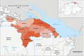
The canton of Friborg is divided into seven districts. Their reduction in numbers and their reorganization were declared failed by the State Council in 2010 due to regional resistance.
As of January 1, 2017

| district | Population (December 31, 2018) |
Area in km² |
Administrative headquarters | Number of municipalities |
language |
|---|---|---|---|---|---|
| Broye | 32,894 | 172.59 | Estavayer | 19th | French |
| Glane (French Glâne ) | 24,337 | 168.66 | Romont | 168.67 | French |
| Gruyere (fr. Gruyère ) | 55,726 | 489.84 | Cop | 25th | French¹ |
| Saane (French Sarine ) | 106,136 | 217.75 | Freiburg | 28 | French German |
| Lake (French Lac ) | 36,800 | 144.83 | Murten | 17th | French German |
| Sense (fr. Singine ) | 43,990 | 265.26 | Tafers | 17th | German |
| Vivisbach (French: Veveyse ) | 18,831 | 134.30 | Châtel-Saint-Denis | 9 | French |
| Total (7) | 318,714 | 1671.42 | Freiburg | 133 | French German |
The share of the lake area in the canton of Friborg is 78.14 km² (Lac de la Gruyère / Lake Gruyère 8.56 km², shares: Lake Neuchâtel / Lac de Neuchâtel 55.19 km² and Lake Murten / Lac de Morat 14.39 km²). Thus, the total area of the canton of Friborg is 1,671.42 km².
¹ (French-speaking with the only German-speaking municipality Jaun )

Districts of the canton of Friborg until 1999

- As a result of the merger of the municipalities of Corsalettes with Grolley on January 1, 2000, the area of the former municipality of Corsalettes changes from the district of See to the district of Saane.

Canton of Solothurn

The canton of Solothurn is divided into ten districts, which are grouped into five offices . Since 2005, only the offices have been relevant from an administrative point of view; the districts only have a statistical function. As of January 1, 2014
| district | Population (December 31, 2018) |
Area in km² |
main place | Number of municipalities |
Office |
|---|---|---|---|---|---|
| Bucheggberg | 7921 | 62.68 | Buchegg | 8th | Bucheggberg water authority |
| Dorneck | 20,521 | 74.70 | Dornach | 11 | Dorneck-Thierstein |
| Gäu | 21,403 | 62.05 | Oensingen | 8th | Thal-Gäu |
| Gösgen | 24,441 | 68.67 | Niedergösgen | 11 | Olten-Gösgen |
| Livers | 45,870 | 117.17 | Grenchen | 15th | Solothurn livers |
| Olten | 55,372 | 80.57 | Olten | 15th | Olten-Gösgen |
| Solothurn | 16,777 | 6.28 | Solothurn | 1 | Solothurn livers |
| Thal | 14,712 | 139.39 | Balsthal | 9 | Thal-Gäu |
| Thierstein | 14,640 | 102.27 | Breitenbach | 12 | Dorneck-Thierstein |
| Water authority | 51,537 | 76.67 | Kriegstetten | 19th | Bucheggberg water authority |
| Total (10) | 273,194 | 790.45 | Solothurn | 109 | - |

Districts of the canton of Solothurn until 1990

Offices of the Canton of Solothurn


Canton of Basel-Stadt
The canton of Basel-Stadt is not divided into districts, but into three municipalities. The total area of the canton of Basel-Stadt is 36.95 km².

Until 1889, however, there were two districts in Basel-Stadt: the urban district with the municipality of Basel and the rural district with the municipalities of Kleinhüningen , Riehen and Bettingen .

Canton of Basel-Country
The canton of Basel-Landschaft is divided into five districts:

| district | Population (December 31, 2018) |
Area in km² |
main place | Number of municipalities |
|---|---|---|---|---|
| Arlesheim | 155,854 | 96.22 | Arlesheim | 15th |
| To run | 19,912 | 89.56 | To run | 13 |
| Liestal | 60,618 | 85.86 | Liestal | 14th |
| Sissach | 35,783 | 141.04 | Sissach | 29 |
| Waldenburg | 15,965 | 104.99 | Waldenburg | 15th |
| Total (5) | 288,132 | 517.67 | Liestal | 86 |

Districts of the canton of Basel-Landschaft until December 31, 1993

- Before the change of the Laufental to the canton of Basel-Landschaft on January 1, 1994, the district of Laufen belonged to the canton of Bern.
- The division of the Arlesheim district into a Birstal district and a Birsigtal district was discussed in the 1990s; it is by far the most populous district. However, in order not to give the lower part of the canton greater weight, the matter was no longer pursued.

Canton of Schaffhausen
The canton of Schaffhausen was divided into six districts.

In July 1999, the district administrations were abolished in the canton. The territories of the districts themselves remained as statistical units. The electoral districts of the Cantonal Council , which have been in force since 2003, are mostly not congruent with these : Schaffhausen, Klettgau, Neuhausen, Reiat, Stein and Buchberg-Rüdlingen.
As of January 1, 2013
| district | Population (December 31, 2018) |
Area in km² |
Number of municipalities |
|---|---|---|---|
| Oberklettgau | 4597 | 31.88 | 3 |
| Reiat | 9006 | 39.33 | 5 |
| Schaffhausen | 54,691 | 105.73 | 7th |
| Schleitheim | 3043 | 43.63 | 3 |
| stone | 5668 | 30.97 | 4th |
| Unterlettgau | 4986 | 46.61 | 4th |
| Total (6) | 81,991 | 298.42 | 26th |
The land area in the canton of Schaffhausen is 298.16 km², the lake area is 0.26 km² (= part of Lake Constance). The total area of the canton of Schaffhausen is 298.42 km².

Districts of the canton of Schaffhausen until 2004

Districts of the canton of Schaffhausen until 2012


- As a result of the merger of the municipalities of Osterfingen with Wilchingen on January 1, 2005, the area of the former municipality of Osterfingen changes from the Oberklettgau district to the Unterklettgau district.
- As a result of the merger of the communities of Guntmadingen with Beringen on January 1, 2013, the area of the former community of Guntmadingen changes from the Oberklettgau district to the Schaffhausen district.
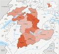
One also speaks of the upper part of the canton (Stein district) and the lower part of the canton (municipalities of Rüdlingen and Buchberg) in relation to their location on the Rhine and their geographical separation from most of the canton of Schaffhausen (see map).

Canton of Appenzell Ausserrhoden
The canton of Appenzell Ausserrhoden was divided into three districts.

In 1995, the district administrations were abolished in the canton. The districts themselves remained as statistical units.
| district | Population (December 31, 2018) |
Area in km² |
Number of municipalities |
|---|---|---|---|
| Backland | 24,393 | 136.16 | 7th |
| Mittelland | 17'272 | 60.27 | 5 |
| Foreland | 13,569 | 46.41 | 8th |
| Total (3) | 55'234 | 242.84 | 20th |

Canton of Appenzell Innerrhoden
In the canton of Appenzell Innerrhoden , the districts are the lowest administrative unit. They correspond to the political communities of other cantons. Innerrhoden is divided into 6 districts:

| district | Population (December 31, 2018) |
Area in km² |
|---|---|---|
| Appenzell | 5795 | 16.88 |
| Gonten | 1462 | 24.73 |
| Oberegg | 3648 | 40.82 |
| Rute | 1128 | 17.93 |
| Schlatt-Haslen | 2196 | 57.51 |
| Schwende | 1916 | 14.61 |
| Total (6) | 16'145 | 172.48 |

Districts of the canton of Appenzell Innerrhoden until 1996

In addition to the districts, Appenzell Innerrhoden knows two parts of the country, the interior (includes the main part of the canton) and the exterior (identical to the Oberegg district ). These perform tasks that in other cantons are partly assigned to the communes and partly to the districts; they are, for example, the bearers of community citizenship.

Canton of St. Gallen
The canton of St. Gallen has been divided into eight constituencies since 2003. Although these do not serve to decentralize the cantonal administration, they are managed by the Federal Statistical Office in the sense of districts.

| Constituency | Population (December 31, 2018) |
Area in km² |
Number of municipalities |
|---|---|---|---|
| Rhine Valley | 73,094 | 138.94 | 13 |
| Rorschach | 43,142 | 50.45 | 9 |
| Sarganserland | 40,714 | 517.74 | 8th |
| Sea gaster | 67,089 | 245.86 | 10 |
| St. Gallen | 122,419 | 157.67 | 9 |
| Toggenburg | 46,452 | 488.59 | 12 |
| Werdenberg | 39,193 | 206.51 | 6th |
| Wil | 75,594 | 145.24 | 10 |
| Total (8) | 507,697 | 2028.20 | 77 |
The land area of the canton of St. Gallen is 1,951.09 km², the lake area is 79.67 km² (parts of Lake Constance 49.25 km², Walensee 19.48 km², Lake Zurich 10.94 km²). The total area of the canton of St. Gallen is therefore 2,030.76 km².

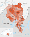
canton of Grisons
The canton of Graubünden has been divided into eleven regions since January 1, 2016. They essentially correspond to the natural landscape areas. By December 31, 2017 there will be 4 additional circles.
As of January 1, 2017

| region | Population (December 31, 2018) |
Area in km² |
Inhabitant per km² |
Number of municipalities |
|---|---|---|---|---|
| Albula | 8120 | 683.51 | 12 | 6th |
| Bernina | 4629 | 237.31 | 20th | 2 |
| Engiadina Bassa / Val Müstair | 9200 | 1196.53 | 8th | 5 |
| In the ground | 20,970 | 203.80 | 103 | 7th |
| Landquart | 25'157 | 174.67 | 144 | 8th |
| Maloja | 18,259 | 973.57 | 19th | 12 |
| Moesa | 8566 | 496.06 | 17th | 12 |
| Plessure | 42,315 | 285.30 | 148 | 5 |
| Prättigau / Davos | 26,083 | 853.40 | 31 | 11 |
| Surselva | 21,483 | 1373.56 | 16 | 15th |
| Viamala | 13,597 | 627.59 | 22nd | 22nd |
| Total (11) | 198,379 | 7105.30 | 28 | 105 |
The canton of Graubünden was divided into eleven districts until December 31, 2015. They essentially corresponded to the natural landscape areas. The districts were again divided into 39 districts.
As of January 1, 2014


| district | Population (December 31, 2015) |
Area in km² |
Number of municipalities |
Circles |
|---|---|---|---|---|
| Albula | 8210 | 723.13 | 16 | Alvaschein , Belfort , Bergün , Surses |
| Bernina | 4619 | 237.31 | 2 | Brusio , Poschiavo |
| Hinterrhein | 13,179 | 617.67 | 24 | Avers , Domleschg , Rheinwald , Schams , Thusis |
| In the ground | 20,158 | 203.81 | 7th | Rhäzüns , Trins |
| Inn | 9476 | 1,196.55 | 5 | Sur Tasna , Ramosch , Suot Tasna , Val Müstair |
| Landquart | 25,555 | 193.19 | 9 | Five villages , Maienfeld |
| Maloja | 18,698 | 973.65 | 12 | Bergell , Upper Engadin |
| Moesa | 8426 | 496.05 | 14th | District of Calanca , Misox , Roveredo |
| Plessure | 40,707 | 266.73 | 5 | Chur , Churwalden , Schanfigg |
| Prättigau-Davos | 26'257 | 823.74 | 13 | Davos , Jenaz , Klosters , Küblis , Luzein , Schiers , Seewis |
| Surselva | 21,325 | 1,373.56 | 18th | Cadi / Disentis , Ilanz , Lumnezia / Lugnez , Ruis , Safien |
| Total (11) | 196,610 | 7,105.39 | 125 | (39) |
- As a result of the merger of the municipalities of Davos and Wiesen on January 1, 2009, the area of the former municipality of Wiesen (29.58 km²) changes from the Albula district to the Prättigau / Davos district.

Districts of the canton of Graubünden until 2008

By the end of 2000, the canton of Graubünden was divided into 14 districts.
On January 1, 2001, the Glenner and Vorderrhein districts and the Safien district of the Heinzenberg district merged to form the Surselva district. The remaining two districts of the Heinzenberg district were incorporated into the Hinterrhein district, and the Val Müstair district became part of the Inn district.

| district | Area in km² |
Number of municipalities |
Circles |
|---|---|---|---|
| Albula | 723.05 | 23 | Alvaschein , Belfort , Bergün , Surses |
| Bernina | 237.30 | 2 | Brusio , Poschiavo |
| Glenner | 696.14 | 37 | Ilanz , Lumnezia / Lugnez , Ruis |
| Heinzenberg | 263.07 | 24 | Domleschg , Safien , Thusis |
| Hinterrhein | 466.41 | 16 | Obverse , Rheinwald , Schams |
| In the ground | 203.81 | 7th | Rhäzüns , Trins |
| Inn | 997.91 | 12 | Ramosch , Sur Tasna , Suot Tasna |
| Maloja | 973.65 | 16 | Bergell , Upper Engadin |
| Moesa | 496.05 | 17th | District of Calanca , Misox , Roveredo |
| Oberlandquart | 669.25 | 11 | Davos , Jenaz , Klosters , Küblis , Luzein |
| Plessure | 266.75 | 16 | Chur , Churwalden , Schanfigg |
| Unterlandquart | 347.82 | 16 | Five villages , Maienfeld , Schiers , Seewis |
| Val Müstair | 198.65 | 6th | Munster Valley |
| Vorderrhein | 565.53 | 7th | Cadi / Disentis |
| Total (14) | 7,105.39 | 210 | (39) |
Districts of the Canton of Graubünden until 1991

- Renaming of the Münstertal district to Val Müstair .

Kanton Aargau
The Aargau is divided into eleven districts:
as of January 1, 2013

| district | Population (December 31, 2019) |
Area in km² |
main place | Number of municipalities |
|---|---|---|---|---|
| Aarau | 79,185 | 104.49 | Aarau | 12 |
| to bathe | 145,198 | 153.09 | to bathe | 26th |
| Bremgarten | 78,080 | 117.47 | Bremgarten AG | 22nd |
| Brugg | 51'416 | 145.11 | Brugg | 23 |
| Kulm | 42,145 | 97.27 | Unterulm | 17th |
| Laufenburg | 32,854 | 156.74 | Laufenburg | 18th |
| Lenzburg | 64,356 | 98.10 | Lenzburg | 20th |
| Muri | 36,858 | 138.95 | Muri AG | 19th |
| Rheinfelden | 47,983 | 111.86 | Rheinfelden | 14th |
| Zofingen | 72,680 | 142.01 | Zofingen | 17th |
| Zurzach | 34,669 | 130.01 | Bad Zurzach | 22nd |
| Total (11) | 685,424 | 1403.80 | Aarau | 210 |
The land area of the canton of Aargau is 1,395.11 km², the lake area is 8.69 km² ( Hallwilersee ). The total area of the canton is 1,403.80 km².

Districts of the Canton of Aargau until 2009

- As a result of the merger of the municipalities of Hottwil, Etzgen, Mettau, Oberhofen (AG) and Wil (AG) on January 1, 2010, the area of the former municipality of Hottwil (4.16 km²) changes from the Brugg district to the Laufenburg district.

Canton of Thurgau
Since January 1, 2011, the canton of Thurgau has only been divided into five districts:

| district | Population (December 31, 2018) |
Area in km² |
main place | Number of municipalities |
|---|---|---|---|---|
| Arbon | 56,638 | 89.07 | Arbon | 12 |
| Frauenfeld | 68,334 | 279.61 | Frauenfeld | 23 |
| Kreuzlingen | 48,345 | 129.17 | Kreuzlingen | 14th |
| Münchwilen | 47,325 | 138.19 | Münchwilen | 13 |
| Weinfelden | 55,830 | 227.08 | Weinfelden | 18th |
| Total (5) | 276,472 | 994.33 | Frauenfeld | 80 |
The land area of the canton of Thurgau is 863.11 km², the proportion of lake area on Lake Constance is 128.66 km². The total area of the canton of Thurgau is 991.77 km².
The canton of Thurgau was divided into eight districts until December 31, 2010:

| district | Residents (December 31, 2010) |
Area in km² |
main place | Number of municipalities |
|---|---|---|---|---|
| Arbon | 39,177 | 69.85 | Arbon | 11 |
| Bischofszell | 31,773 | 92.73 | Bischofszell | 8th |
| Diessenhofen | 6,621 | 41.25 | Diessenhofen | 3 |
| Frauenfeld | 45,737 | 133.12 | Frauenfeld | 11 |
| Kreuzlingen | 39,947 | 106.75 | Kreuzlingen | 12 |
| Münchwilen | 37,599 | 157.11 | Münchwilen | 15th |
| Steckborn | 18'215 | 138.15 | Steckborn | 12 |
| Weinfelden | 25,736 | 123.95 | Weinfelden | 8th |
| Total (8) | 244,805 | 863.11 | Frauenfeld | 80 |

Districts of the canton of Thurgau until December 31, 1924

Districts of the canton of Thurgau until December 31, 1935
Districts of the canton of Thurgau until December 31, 1994

Districts of the canton of Thurgau until December 31, 1995


- December 31, 1924: Due to the merger of the municipality of Hemmerswil with Amriswil , the area of Hemmerswil changes from the Arbon district to the Bischofszell district.
- December 31, 1935: The area of Niederaach changes from the Arbon district to the Bischofszell district as a result of the land exchange of the village of Niederaach from the municipality of Hefenhofen to the municipality of Oberaach .
- December 31, 1994: Due to the merger of the municipality of Weiningen with the municipality of Warth , the area of Weiningen changes from the Steckborn district to the Frauenfeld district.
- December 31, 1994: Due to the merger of the municipality of Wetzikon with the municipality of Thundorf , the area of Wetzikon changes from the Münchwilen district to the Frauenfeld district.
- December 31, 1995: As a result of the merger of the localities of Heiterschen and Jakobstal from the municipality of Wittenwil to the municipality of Wängi , the area of these two localities changes from the Frauenfeld district to the Münchwilen district.
- December 31, 1995: Due to the merger of the communities Dotnacht and Hugelshofen to the community Kemmental , the area of these two communities changes from the district of Weinfelden to the district of Kreuzlingen.
- December 31, 1995: As a result of the merger of the communities Donzhausen and Hessenreuti to form the community Sulgen , the area of these two communities changes from the Weinfelden district to the Bischofzell district.

Canton of Ticino
The canton of Ticino (Repubblica e Cantone Ticino) is divided into eight districts (distretti), these in turn into 38 districts (circoli; today only justice of the peace district):
As of April 10, 2016


| District / Distretto | Population (December 31, 2018) |
Area in km² |
main place | Number of municipalities |
Circles |
|---|---|---|---|---|---|
| Bellinzona | 55,711 | 226.33 | Bellinzona | 6th | Arbedo-Castione , Bellinzona , Sant'Antonino |
| Blenio | 5682 | 360.58 | Acquarossa | 3 | Acquarossa , Malvaglia , Olivone |
| Leventina | 9113 | 479.55 | Faido | 10 | Giornico , Faido , Quinto , Airolo |
| Locarno | 64,075 | 550.57 | Locarno | 23 | Gambarogno , Isole , Locarno , Melezza , Navegna district , Onsernone , Verzasca |
| Lugano | 151,592 | 307.94 | Lugano | 52 | Agno , Breno , Capriasca , Ceresio , Lugano North , Lugano East , Lugano West , Magliasina , Paradiso , Sessa , Taverne , Vezia |
| Mendrisio | 50,865 | 100.75 | Mendrisio | 11 | Balerna , Caneggio , Mendrisio , Riva San Vitale , Stabio |
| Riviera | 10,335 | 145.60 | Riviera | 2 | Riviera |
| Vallemaggia | 5970 | 569.37 | Cevio | 8th | Lavizzara , Maggia , Rovana |
| Total (8) | 353,343 | 2812.16 | Bellinzona | 115 | (38) |
The land area in the canton of Ticino is 2741.03 km², the lake area is 71.17 km² (Lago di Lugano / Luganersee 29.80 km², Lago Maggiore / Langensee 41.37 km²). The total area of the canton of Ticino is thus 2,812.20 km².

Districts of the canton of Ticino until 11.2010
Districts of the canton of Ticino until 04.2013

Districts of the canton of Ticino until 04/2016

Districts of the canton of Ticino until 04.2017

Districts of the canton of Ticino until 04.2017


- As a result of the merger of the municipalities of Bironico, Camignolo, Medeglia, Rivera and Sigirino on November 21, 2010, the area of the former municipality of Medeglia (6.27 km²) changes from the Bellinzona district to the Lugano district.
- Due to the merger of the municipality of Carona with Lugano on April 14, 2013, the municipality of Carona in Paradiso was renamed.
- With the merger of the municipalities of Bogno, Cadro, Certara, Cimadera, Sonvico and Valcolla with Lugano on April 14, 2013, the Sonvico district was dissolved.
- As a result of the merger of the municipalities of Camorino, Claro, Giubiasco, Gnosca, Gorduno, Gudo, Moleno, Monte Carasso, Pianezzo, Preonzo, Sant'Antonio and Sementina with Bellinzona on April 2, 2017, the area of the former municipality of Claro (21.22 km² ) from the Riviera district to the Bellinzona district.
- As a result of the merger of the municipalities of Camorino, Claro, Giubiasco, Gnosca, Gorduno, Gudo, Moleno, Monte Carasso, Pianezzo, Preonzo, Sant'Antonio and Sementina with Bellinzona on April 2, 2017, the two districts of Giubiasco and Ticino were dissolved. The Arbedo-Castione and Sant'Antonino districts were newly formed.
Source: Decreto esecutivo concernente le Circoscrizioni dei Comuni, Circoli e Distretti del 25 giugno 1803

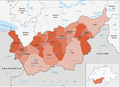
Canton of Vaud
With effect from September 1, 2006, the "Loi sur le découpage territorial (LDecTer) du 30 may 2006" (law on spatial structure of May 30, 2006) came into force. It is valid for the first time in 2007 for the elections to the Grand Conseil. Since January 1, 2008, there are only 10 districts ( French districts ) in the canton of Vaud , the district level has been abolished without replacement.

- Structure since 2008
As of January 1, 2017
| district | Population (December 31, 2018) |
Area in km² |
main place | Number of municipalities |
|---|---|---|---|---|
| Aigle | 45,589 | 434.99 | Aigle | 15th |
| Broye-Vully | 43,145 | 258.01 | Payerne | 31 |
| Gros-de-Vaud | 45'258 | 232.20 | Echallens | 37 |
| Jura north vaudois | 91,971 | 700.99 | Yverdon-les-Bains | 73 |
| Lausanne | 166,367 | 65.14 | Lausanne | 6th |
| Lavaux-Oron | 62,329 | 140.02 | Bourg-en-Lavaux | 17th |
| Morges | 82,609 | 373.07 | Morges | 62 |
| Nyon | 100,685 | 307.36 | Nyon | 47 |
| Ouest lausannois | 76'212 | 26.34 | Renens | 8th |
| Riviera-Pays-d'Enhaut | 84,980 | 282.92 | Vevey | 13 |
| Total (10) | 799,145 | 3212.02 | Lausanne | 309 |
The land area of the canton is 2,821.08 km². The share of the lake area in the canton of Vaud is 390.93 km² ( Lac de Joux 8.79 km², shares: Lake Geneva / Lac Léman 297.83 km², Lake Neuchâtel / Lac de Neuchâtel 75.99 km² and Lake Murten / Lac de Morat 8.32 km²) . Thus the total area of the canton of Vaud is 3212.01 km².

Districts of the canton of Vaud until 2012

Districts of the canton of Vaud until 2016


- As a result of the merger of the municipality of Chanéaz with other municipalities to form the municipality of Montanaire on December 31, 2012, the area of the former municipality of Chanéaz changes from the Jura-Nord vaudois district to the Gros-de-Vaud district.
- As a result of the merger of the municipality of Carrouge with other municipalities to form the municipality of Jorat-Mézières on June 30, 2016, the area of the former municipality of Carrouge changes from the district of Broye-Vully to the district of Lavaux-Oron.
- Outline 1803-2007
From 1803 to 2007, the canton of Vaud was divided into 19 districts. The districts were further subdivided into a total of 61 districts ( French cercles ):

Status: end of 2006

Districts of the canton of Vaud until December 31, 1959

- January 1, 1960: The Bercher municipality moves from the Moudon district to the Echallens district .
Source: Loi du 14 juin 1803 sur la division du canton en districts

Canton of Valais
The canton of Valais is divided into 13 districts, with the Raron district consisting of two semi- districts since 1987. Each district of Valais is headed by a prefect and a vice-prefect. As of January 1, 2017 .

| district | translated | Population (December 31, 2018) |
Area in km² |
main place | Number of municipalities |
|---|---|---|---|---|---|
| Brig | French Brigue | 26,911 | 434.19 | Brig-Glis | 7th |
| Conthey | German Gundis | 28,906 | 234.20 | Conthey | 5 |
| Entremont | 15,261 | 632.97 | Sembrancher | 6th | |
| Goms | French Conches | 4440 | 589.20 | Münster-Geschinen | 8th |
| Hérens | German Ering | 10,862 | 466.07 | Vex | 6th |
| Leuk | French Loèche | 12,355 | 335.27 | Leuk | 12 |
| Martigny | German Martinach | 47,983 | 263.37 | Martigny | 11 |
| Monthey | 47,039 | 256.78 | Monthey | 9 | |
|
West of Raron East of Raron |
French Rarogne (two semi-districts) |
10,940 | 398.16 |
Raron and Mörel fillet |
11 6 |
| Saint-Maurice | 13,821 | 190.59 | Saint-Maurice | 9 | |
| Sierre | French Sierre | 49'230 | 418.37 | Sierre | 12 |
| Manners | French Sion | 47,753 | 130.66 | Manners | 5 |
| Visp | French Viège | 28,454 | 864.20 | Visp | 19th |
| Total (13) | 343,955 | 5224.63 | Manners | 126 |
The land area of the canton of Valais covers 5,214.00 km², the lake area is 10.60 km² ( Lake Geneva / Lac Léman). Thus the total area is 5,224.60 km².
Districts of the canton of Valais until December 31, 2016

- January 1, 2017: As a result of the merger of the municipality of Les Agettes with Sion , the municipality of Les Agettes changes from the district of Hérens to the district of Sion .

Canton of Neuchâtel
The Canton of Neuchâtel was up on 31 December 2017 in six districts ( French Districts ) divided geographical to four regions included. From January 1, 2018, the latter will each form an electoral region, which are combined into a single constituency , and will also serve statistical purposes. They do not have any administrative tasks (as of January 1, 2018) .


| District until December 31, 2017 |
Population (December 31, 2017) |
Area in km² |
main place | Number of municipalities |
Region from January 1, 2018 |
|---|---|---|---|---|---|
| Boudry | 40,701 | 105.46 | Boudry | 7th | Littoral |
| La Chaux-de-Fonds | 39,796 | 92.99 | La Chaux-de-Fonds | 3 | Mondays |
| Le Locle | 14'414 | 143.74 | Le Locle | 7th | Mondays |
| Neuchâtel (French Neuchâtel ) | 53,744 | 80.02 | Neuchâtel | 9 | Littoral |
| Val-de-Ruz | 17,411 | 128.07 | Cernier | 2 | Val-de-Ruz |
| Val-de-Travers | 11,898 | 166.44 | Môtiers | 3 | Val-de-Travers |
| Total (6) | 177,964 | 716.72 | Neuchâtel | 31 | (4) |
The land area of the canton of Neuchâtel covers 716.72 km², the lake area is 85.44 km² ( Lake Neuchâtel / Lac de Neuchâtel 84.91 km², Lake Biel 0.53 km²). Thus the total area is 802.16 km².

Districts of the canton of Neuchâtel until December 31, 1850

- December 31, 1850: When the commune of Les Eplatures is spun off from Le Locle , the area of Les Eplatures changes from the Le Locle district to the La Chaux-de-Fonds district.

Canton of Geneva
The canton of Geneva is not divided into districts. The land area of the canton of Geneva covers 245.82 km², the lake area is 36.67 km² (Lake Geneva / Lac Léman). Thus the total area is 282.49 km².

Canton of Jura
The canton of Jura is divided into three districts: As of January 1, 2013

| district | Population (December 31, 2018) |
Area in km² |
main place | Number of municipalities |
|---|---|---|---|---|
| Delsberg (French: Delémont ) | 38,590 | 303.18 | Delémont | 19th |
| Freiberge (fr. Franches-Montagnes ) | 10,389 | 200.23 | Saignelégier | 13 |
| Pruntrut (French Porrentruy ) | 24'440 | 335.10 | Pruntrut | 21st |
| Total (3) | 73'419 | 838.51 | Delémont | (53) |

Districts of the canton of Jura until 2008

- Through the merger on January 1, 2009 of the municipalities of Epauvillers, Epiquerez, Montenol, Montmelon, Ocourt, Saint-Ursanne and Seleute to the municipality of Clos du Doubs , the area of the former municipalities of Epauvillers and Epiquerez was assigned to the Pruntrut district.
See also
Web links
- Anne-Marie Dubler : District. In: Historical Lexicon of Switzerland .
- Districts of the Canton of Zurich
- Constituencies of the Canton of Lucerne
- Districts of the Canton of Schwyz
- Districts of the canton of Friborg
- Districts of the canton of Solothurn
- Districts of the canton of Basel-Landschaft
- Districts of the canton of Appenzell Innerrhoden
- Districts of the canton of St. Gallen
- Districts of the canton of Graubünden
- Districts of the canton of Thurgau
- Districts of the canton of Vaud
- Districts of the canton of Neuchâtel
Individual evidence
- ↑ a b c d e f Federal Statistical Office Generalized Limits 2020.
- ^ Law on the organization of the government council and administration (BSG 152.01; online ).
- ↑ Law on the special statute of the Bernese Jura and on the French-speaking minority of the bilingual district of Biel (BSG 102.15), Art. 4 ( online ).
- ↑ Prefects and Vice-Prefects of the Canton of Valais , accessed on December 4, 2017.