Bundesstrasse 321
| Bundesstrasse 321 in Germany | |

|
|
| map | |
| Basic data | |
| Operator: |
|
| Overall length: | 98 km |
|
State : |
|
| Development condition: | 2 × 1 and 2 × 2 lanes in Schwerin |
| B 321 in Tessenow | |
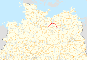
The federal highway 321 (abbreviation: B 321 ) is mainly in Mecklenburg-Western Pomerania and with a 270 meter long section in Brandenburg . It branches off in Pritzier on the B 5 and heads north-east to Schwerin . From Schwerin it turns to the southeast and ends shortly after the state border with Brandenburg on the A 24 at the Suckow junction . The B 321 has a total length of 98 kilometers.
Cities on federal highway 321:
history
The road between Schwerin and Parchim was built as a road between 1858 and 1859 . Ten years later (1868–1871) this street was extended to the Brandenburg town of Putlitz .
The national highway 321 was established around 1938 and led originally by Pritzier to Schwerin. Since the 1960s, the now called 321 road led from Schwerin to Pritzwalk, the section southwest of Schwerin had been downgraded. Only since reunification has the current federal highway 321 encompassed both sections.
The section between the Suckow junction on the A 24 via Putlitz to Pritzwalk was rededicated to the L 111 in 2005.

