Bundesstrasse 13

from Wikipedia, the free encyclopedia
Template: Infobox high-ranking street / Maintenance / DE-B
Bundesstrasse 13 in Germany
Bundesstrasse 13
map
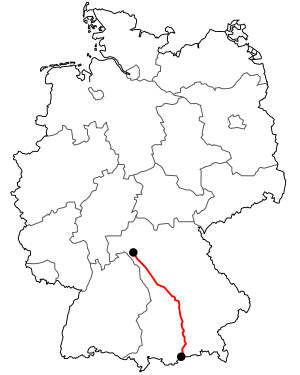
Course of the B 13
Basic data
Operator: GermanyGermany Federal Republic of Germany
Start of the street: Würzburg
( 49 ° 46 ′  N , 9 ° 57 ′  E )
End of street: Lenggries
( 47 ° 35 ′  N , 11 ° 33 ′  E )
Overall length: 342 km

State :

Development condition: two-lane
McGraw Trench.JPG
Bundesstrasse 13 in Munich ( McGraw-Graben )
Course of the road
Free State of Bavaria
Independent city of Würzburg
Locality Wurzburg B19
Würzburg district
Bypass Randersacker bypass 
Junction (71)  Würzburg / Randersacker A3 E43
Locality Eibelstadt
Locality Sommerhausen
Locality Ochsenfurt
flow Main ( New Main Bridge Ochsenfurt 238 m)
bridge Railway bridge ( Treuchtlingen – Würzburg line )
Kitzingen district
Locality Market wide
Neustadt an der Aisch-Bad Windsheim district
Locality Oberickelsheim
Junction (105)  Gollhofen A7 E43
Locality Gollhofen
Locality Uffenheim
flow Gollach
bridge Treuchtlingen – Würzburg railway line
Locality Uffenheim OT Rudolzhofen
Locality Ergersheim OT Neuherberg
Locality Burgbernheim OT Pfaffenhofen
flow Rannach
Locality Burgbernheim OT Buchheim
Locality Burgbernheim OT Schwebheim
crossing Bad Windsheim B470
Bypass Marktbergel OT Ottenhofen bypass
bridge Neustadt (Aisch) –Steinach near Rothenburg railway line
Bypass Marktbergel bypass 
bridge Railway bridge ( Treuchtlingen – Würzburg line )
Ansbach district
Motorway junction Oberdachstetten
Bypass Lehrberg OT Gräfenbuch bypass
bridge Treuchtlingen – Würzburg railway line
flow Franconian Rezat
Locality Lehrberg
Independent city of Ansbach
Locality Ansbach B14
flow Franconian Rezat
bridge Railway bridge ( Treuchtlingen – Würzburg
line and Nuremberg – Crailsheim line )
Motorway junction Ansbach Deßmannsdorf
node (52)  Ansbach A6 E50
Ansbach district
Bypass Burgoberbach bypass 
Bypass Weidenbach OT Triesdorf bypass 
bridge Treuchtlingen – Würzburg railway line
Bypass Merkendorf bypass 
Weissenburg-Gunzenhausen district
Bypass Muhr am See bypass 
bridge Treuchtlingen – Würzburg railway line
Locality Schlungenhof
flow Heidweihergraben
flow Altmühlüberleiter
Bypass Gunzenhausen bypass  B466
flow Altmuehl
bridge Railway bridge ( Treuchtlingen – Würzburg
railway and Nördlingen – Gunzenhausen railway )
flow Merzelfeldgraben
flow Altmuehl
Locality Gunzenhausen OT Unterasbach
Locality Theilenhofen OT Dornhausen
flow Dornhauser Mühlbach
Locality Theilenhofen
Locality Ellingen OT Stopfenheim
flow Knöpfelbach
Locality Ellingen OT Massenbach
Bypass Ellingen bypass  B2
bridge Railway bridge ( Treuchtlingen – Nuremberg line )
flow Swabian Rezat
flow Felchbach
flow Rohrbach
Bypass Weissenburg bypass  in Bavaria B2
Locality Weißenburg OT Rothenstein
District of Eichstätt
Locality Schernfeld OT Rupertsbuch
Locality Eichstatt
flow Altmuehl
Railroad Crossing Railway line Eichstätt Bahnhof – Eichstätt city
Bypass Adelschlag OT Pietenfeld bypass 
Bypass Eitensheim bypass 
bridge Railway bridge ( Ingolstadt – Treuchtlingen line )
District-free city of Ingolstadt
Locality beginning Entrance to  Ingolstadt
Locality District Friedrichshofen-Hollerstauden
Locality Mitte district B16a
flow Danube
Locality Munchener Strasse district
Locality District South
flow Sandrach
Village end End of Ingolstadt
Pfaffenhofen an der Ilm district
bridge Railway bridge ( Paartalbahn )
Bypass Manching OT Oberstimm bypass  B16
Bypass Baar-Ebenhausen bypass 
Bypass Reichertshofen bypass 
flow Pair
Motorway junction Reichertshofen-West B300
Motorway junction Pörnbach
Locality Pörnbach
Locality Pfaffenhofen an der Ilm OT Haimpertshofen
Locality Pfaffenhofen on the Ilm
flow Ilm
Locality Reichertshausen
bridge Railway bridge ( high-speed line Nuremberg – Ingolstadt – Munich )
District of Freising
Locality Hohenkammer OT Niernsdorf
flow Glonn
Locality Hohenkammer
Locality Fahrenzhausen
flow Amperes
Locality Fahrenzhausen OT Großnöbach
District of Dachau
Locality Haimhausen
District of Munich
Junction (3)  Unterschleissheim A92 E53
Bypass Unterschleißheim bypass 
bridge Munich – Regensburg railway line
Bypass Oberschleißheim bypass  B471
flow Schleissheim Canal
Junction (12a)  Munich-Neuherberg A99 E52
Independent city of Munich
Locality beginning Beginning of  Munich
Locality District Milbertshofen
Street than Ingolstädter Straße
Street as Leopoldstrasse
Locality District Schwabing-Freimann
crossing Petuelring / Schenkendorfstrasse B2 R
Template: AB / Maintenance / Empty replaced by B2 R E54
Locality Obergiesing
Template: AB / Maintenance / Empty Transition off B2 R E54
Start of expressway Beginning of the motor road
Template: AB / Maintenance / Empty Symbol: Down Stadelheimer Strasse
Street than McGraw ditch
Street as Tegernseer Landstrasse
Locality District Untergiesing-Harlaching
Village end End of Munich
Junction (1)  Munich- Giesing B13n E54
Expressway end Autobahn beginning replaced by B13n E54
Miesbach district
Locality Wooden churches B318
Locality Holzkirchen OT Großhartpenning
Bad Tölz-Wolfratshausen district
Bypass Sachsenkam bypass 
bridge Holzkirchen – Lenggries railway line
Locality Bad Tölz B472
bridge Railway bridge ( Holzkirchen – Lenggries railway line )
Locality Gaißach OT Obergries
Bypass Lenggries bypass 
flow Steinbach
flow Tratenbach
flow Hirschbach
flow Isar
Locality Sylvenstein Speicher B307

The federal highway 13 (abbreviation B 13 ) is a longer federal highway in Bavaria . It leads from the old episcopal residence city of Würzburg in Lower Franconia via the youngest Bavarian city of Ingolstadt and the metropolis of Munich to the shores of Lake Sylvenstein in the Alps , near the border with Austria .

history

The northern section between Ansbach and Ochsenfurt was expanded into a paved road between 1766 and 1773 . The southern section between Munich and Holzkirchen (Upper Bavaria) was also completed in 1790 as part of the highway from Munich to Miesbach .

In the financial period 1819–1823 the roads Ellingen - Gunzenhausen - Ansbach and Ochsenfurt - Würzburg were expanded to roads at the expense of the Bavarian state.

The Bavarian state roads were numbered according to their starting point:

  • State road No. 53: Ingolstadt - Weißenburg
  • State road No. 87: Munich - Tegernsee
  • State road No. 88: Munich - Pfaffenhofen - Ingolstadt
  • State road No. 145: Würzburg - Ansbach - Ellingen

The trunk road 13 (FVS 13) introduced in 1932 , renamed Reichsstrasse 13 (R 13) in 1934, did not lead from Munich to Bad Tölz, but via Bad Aibling and Rosenheim to Kiefersfelden am Inn . This Reichsstraße was replaced on January 6, 1936 by the newly opened Reichsautobahn Munich - Rosenheim and ended in Munich-Schwabing at the B 11 (intersection Leopold- / Ungererstraße). It was not until the 1970s that the road from Munich via Bad Tölz to Sylvensteinsee was elevated to a federal highway.

The B 13 used to be the connecting axis between Würzburg and Munich. With the construction of the Federal Motorway 3 , it has lost this large-scale connection function.

course

Bundesstrasse 13 begins on Bundesstrasse 19 on the edge of the city center of the Lower Franconian district capital Würzburg as Randersackerer Strasse. Along the Main it leads under the name Bocksbeutel - Ferienstraße to Ochsenfurt (at km 17), where it crosses the Main and leads away from it in a southerly direction. Behind Ochsenfurt there is the toll pyramid about 20 meters from the main road . After running through the Franconian heartland and the Frankenhöhe Nature Park , the B 13 reaches Ansbach , the capital of the Central Franconian administrative district, at km 81 .

In Gunzenhausen (at km 116) the road meets the Altmühl , not far from the Altmühltal it passes the town of Weißenburg in Bavaria (at km 136) and continues to the baroque cathedral city of Eichstätt . At km 187 it reaches the Bavarian city of Ingolstadt , runs through large parts of the urban area (including as Münchener Straße ) and crosses the Danube here .

Between mainly agricultural areas, the B 13 now leads to the metropolis of Munich (at km 267), where it merges into the well-known Leopoldstrasse via Ingolstädter Strasse . In the inner city area it is no longer used as a federal road after it has crossed the Mittlerer Ring . In the south, the road runs out of Munich as Tegernseer Landstrasse , but only as a separate federal road again after the Mittlerer Ring junction with Chiemgaustraße . After a short distance in the city area it changes to the federal highway 13 (signposted as A 995 ). The B 13 branched off again at the Sauerlach exit . Rededication to Holzkirchen (intersection St 2073) to St 2573 due to the parallel BAB 8. On an increasingly attractive route, it leads into the Alpine foothills up to Bad Tölz (at km 319).

From here it leads along the upper reaches of the Isar via Lenggries up to the banks of the Sylvenstein reservoir near the Austrian border, where it ends at the mountainous federal highway 307 .

The total length of the federal highway 13 is 342 kilometers, including the canceled section in the city traffic of Munich.

Crossed counties

See also

Web links

Commons : Bundesstrasse 13  - Collection of pictures, videos and audio files

Individual evidence

  1. north and in Munich with four lanes with lane separation
  2. ^ Kingdom of Bavaria (Ed.): Negotiations of the Second Chamber of the Estates Assembly of the Kingdom of Bavaria . First tape of additional layers. FA Fleischmann, Munich 1822, p. 81 ( Download from the Bayerische Staatsbibliothek [PDF; accessed December 8, 2011]).